Omg lol!I created life. And then I destroyed it.
View attachment 330720
You are using an out of date browser. It may not display this or other websites correctly.
You should upgrade or use an alternative browser.
You should upgrade or use an alternative browser.
A Map Shitpost Thread
- Thread starter FancyHat
- Start date


CannedTech
Banned
...
...what?
This is edited from the original I hope? Cause' that's fucking part of Ontario on the Western Sahara.
It's not.This is edited from the original I hope?
Thanks, I was searching for that thread but I didn't know the name.As hilarious as that is, I'd like to suggest putting that here instead. I made this thread for people to show off their own work.
EDIT: You were right; California and Texas each get 4.
I refuse to take credit for setting Texas at 4 the first time around.
More math!
If the House of Reps were expanded to the size of the National People's Congress in China, then Them would have 2850 seats in Congress, California 16, Texas 11, NY and FL 8; IL, PA, and OH get 5; GA, NC, MI, and NJ get 4; VA, WA, AZ, MA, TN, and IN get 3; MO, MD, WI, CO, MN, SC, AL, LA, KY, OR, OK, and CT each get
2; and the rest get 1 representative.
Uff, that's awful. It's so unfair for one state to dominate that much. I'm glad I live in the U. S. of A.

...
...what?
I'm really amazed. How can someone know so many little details about geography, like the fact that the US border is a straight line until it gets to a bump, or know the exact shape of Michigan, without knowing that the U.S. is a pretty big country.
Okay, now I'm looking at it more and I'm figuring out the source of the error. I'm sure I'm slower than a lot of people on this. It looks like they accidentally selected Canada and Alaska, and dragged them southwards in their image editor. The little Michigan/Ohio/Wisconsin country on Hudson Bay is not a country, it's what is not covered up by Canada when it slid down.
France, Spain, and Portugal slid over a little bit too.
Cause' that's fucking part of Ontario on the Western Sahara.
I'm not seeing it. Do you mean that extra bit jutting out with the ghost eyes? How can you tell it's part of Ontario?
CannedTech
Banned
Yeezus...
I'm not seeing it. Do you mean that extra bit jutting out with the ghost eyes? How can you tell it's part of Ontario?
It's got that lake dealie in the center and those two land doodads that jut out from the main thing. Plus the panhandle/peninsula thing is missing from Ontario.
...
...what?
"I like it, but that country on the top left, it's too high up."
"....Canada?"
"Yeah, whatever. It should be lower."
"....that's not how maps work."
"I don't pay you to tell me how to read maps, I pay you to fix them!"
Rosa Luxemburg
Banned
It's like one of those pictures that gets worse the more you look at it"I like it, but that country on the top left, it's too high up."
"....Canada?"
"Yeah, whatever. It should be lower."
"....that's not how maps work."
"I don't pay you to tell me how to read maps, I pay you to fix them!"
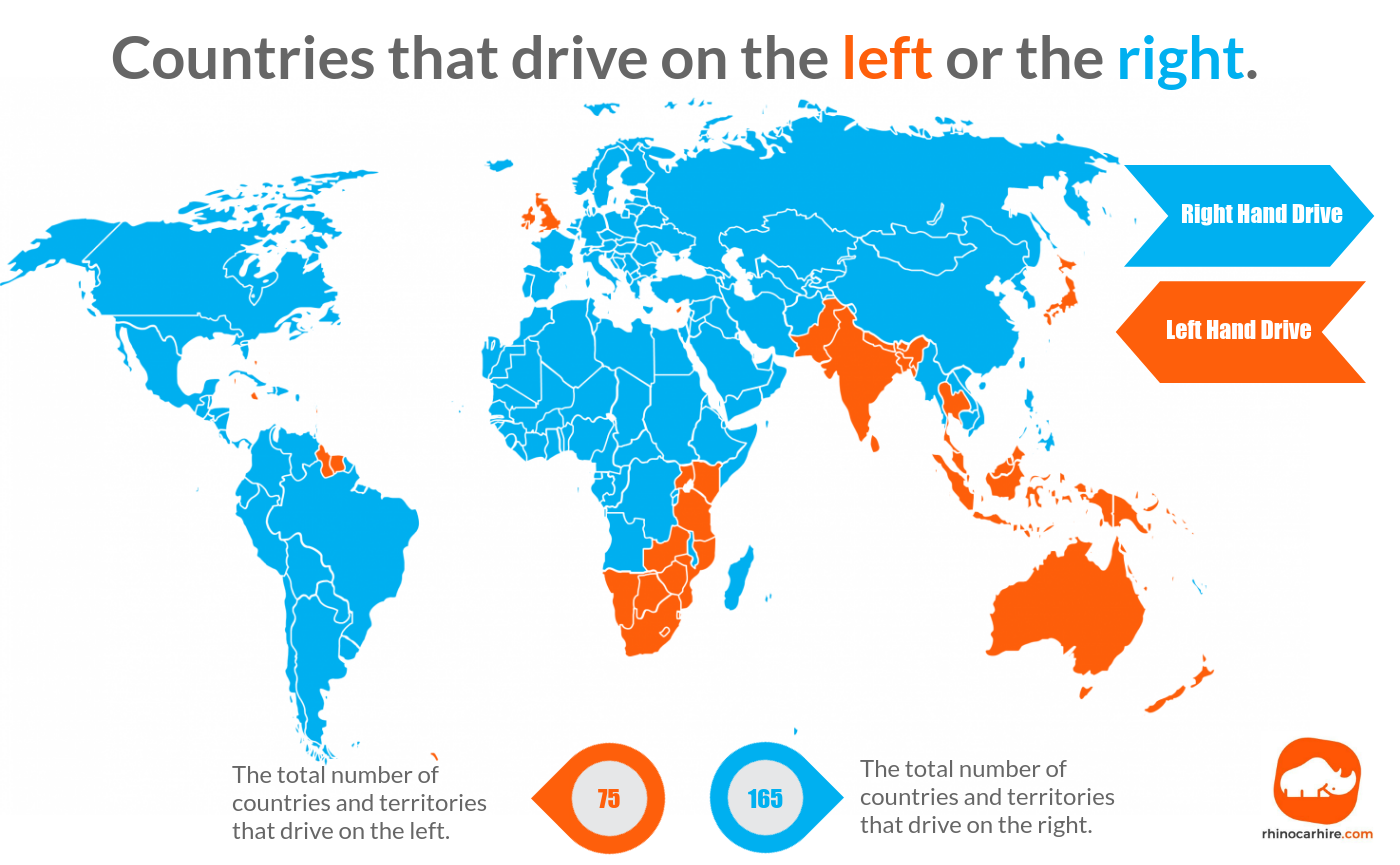
And do they have the numbers mixed?
Yes they do! Wikipedia says 76 countries drive on the left, and 163 on the right. This world standards website lists 91 on the left and 175 on the right.
(countries that drive on the left)
...
...what?
The moral of the story: If Americans keep driving on the right, Queen Elizabeth will put Canada on top of us.
This needs a WorldA"I like it, but that country on the top left, it's too high up."
"....Canada?"
"Yeah, whatever. It should be lower."
"....that's not how maps work."
"I don't pay you to tell me how to read maps, I pay you to fix them!"
This isn't a wip or a shitpost, i just have no other way of getting this image onto my phone.


NYC if it had the UK's stupid island rule.
What island rule?
Share: