Just had read through the last thread and realised that Amelia Roosevelt was actually the Columbian Labour-Welfare leader presumingly making her PM which is funny considering she is actually a Violinist IRL. But rather than Labor Welfare as the main Columbian Left party how about instead a Socialist Farmer-Labour party as a Merger between Socialist parties and possibly something similar to IRL Farmer-Labor, I also prefer the acronym SFL to LW.
You are using an out of date browser. It may not display this or other websites correctly.
You should upgrade or use an alternative browser.
You should upgrade or use an alternative browser.
A Loyal City on the Hill - The Commonwealth Wank
- Thread starter VT45
- Start date
Threadmarks
View all 25 threadmarks
Reader mode
Reader mode
Recent threadmarks
Population of all independent countries in North America, 2020 Flag of Mexico CBC Front page, 16 May 2020 Liberal Alliance target seats Liberal-Conservative target seats Columbian National People's Party target seats Labour-Welfare target seats Green target seats
Mexico Map
VT45
Banned
Sorry for the delay. I work full time and I'm in rehearsals for a play right now. So my time is rather limited right now so it can take several days to make a simple map. But here it is at last: a map of the Federated Captaincies of Mexico.

A world map would be nice. (I think something fun to experiment with would be an Australian commonwealth which was a possibility up until the 1900s)Currently working on the New England general election of 1859, and generating a large map of the provinces that I can use to make the election maps. In the meantime, is there anything you guys would like to see?
anything about Columbia, maybe a list of Prime MinistersCurrently working on the New England general election of 1859, and generating a large map of the provinces that I can use to make the election maps. In the meantime, is there anything you guys would like to see?
VT45
Banned
Okay. I’m currently cobbling together a provincial map that of New England to use for the election map, and then I’ll post some stuff on Columbia.
And @Riley Uhr, I’m not sure what you mean by an Australian Commonwealth in this context. Isn’t that what we have IOTL?
And @Riley Uhr, I’m not sure what you mean by an Australian Commonwealth in this context. Isn’t that what we have IOTL?
I meant Australasian Commonwealth which is Australia NZ and FijiOkay. I’m currently cobbling together a provincial map that of New England to use for the election map, and then I’ll post some stuff on Columbia.
And @Riley Uhr, I’m not sure what you mean by an Australian Commonwealth in this context. Isn’t that what we have IOTL?
Ah so the same as the last thread okayOh I see. Well, Australia’s not that big ITTL, but it does include all of New Guinea
VT45
Banned
Ah so the same as the last thread okay
Most things are the same but I’m changing some stuff
Worse than Subsaharan Africa?! How did that happen?! Also, with California being as well off as Europe, how could a country have that much of a disparity between regions?So rehearsal ran late tonight, so I got the chance to start the map of Mexico, but not finish it. So let’s talk about it instead.
Mexico is a bit smaller than it was in the old version, but it’s still by far the biggest and most populous country in North America. It stretches from OTL Panama to Oregon, and reaches Shreveport in the east. It is home to over 220 million people, and is the largest Spanish speaking country in the world as well as having the biggest economy in the Spanish Commonwealth (name tbd; open to suggestions). It’s basically considered to be one of the countries roughly equivalent to that of the BRICS nations IOTL developmentally and economically. It’s not as developed on average as its British neighbours to the north (it varies wildly; California for example is on par economically with Europe whereas places like Guatemala and Oaxaca are worse than Subsaharan Africa), but it’s still nothing to sneeze at. The new prime minister was swept into power on the pledge to lift the whole of Mexico out of poverty by the end of his term, using the wealth of the far north and centre to subsidise the desert and jungle provinces.
VT45
Banned
Subsaharan Africa ITTL. Which is much better off than IOTL. Like I said, South Africa is leading the way with a GDP per capita and a standard of living on par with OTL Southern Europe. Besides, IOTL Oaxaca has a GDP per capita on par with countries like Ghana, Sudan, and Mauretania. So it's not too far off. Whereas Guatemala is just a bit worse off than ITTL, which has it on par with Cape Verde. Meanwhile, again, California is on par with countries like Norway and Switzerland IOTL. So when you ask what happened, it's basically the same thing as what happened economically IOTL.
Anyway, a little something I've been thinking of to tide you over. I've been thinking about what New England's place is in the Commonwealth of Nations, and I think with how much it devotes to education and innovation, it'd probably be seen as the Tony Stark of the Commonwealth: brilliant, and flush with cash because of it (IOTL New England as its own independent country would have the highest standard of living in the world, and it's the same here). So that got me thinking some more, and so I quickly cobbled this together:

Anyway, a little something I've been thinking of to tide you over. I've been thinking about what New England's place is in the Commonwealth of Nations, and I think with how much it devotes to education and innovation, it'd probably be seen as the Tony Stark of the Commonwealth: brilliant, and flush with cash because of it (IOTL New England as its own independent country would have the highest standard of living in the world, and it's the same here). So that got me thinking some more, and so I quickly cobbled this together:
Last edited:
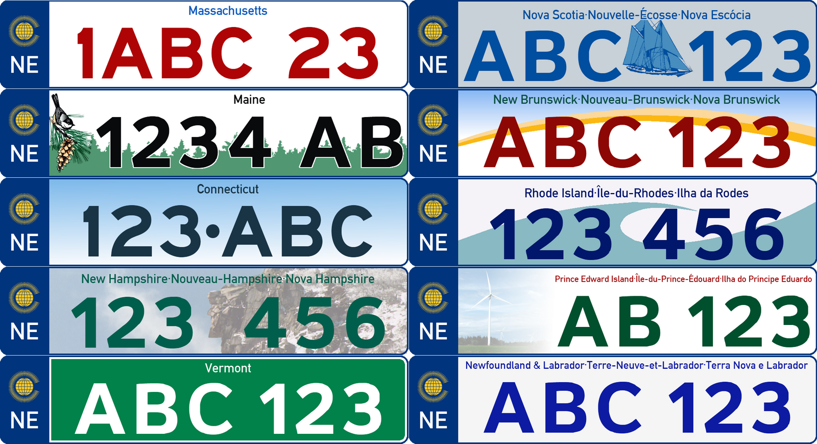
What's the second language on the New Hampshire license plate and what I think is the third on other license plates?I should have a Columbia map up sometime tonight. In the meantime someone bumped the car registration plates thread, so I thought I’d post the New England license plates here. I may end up changing the design but I don’t know yet.
Gian
Banned
What's the second language on the New Hampshire license plate and what I think is the third on other license plates?
It's French and Portuguese (French seems a natural fit, but why Portuguese?)
it's because of the large Portuguese populations in Rhode Island and southern MassachusettsIt's French and Portuguese (French seems a natural fit, but why Portuguese?)
VT45
Banned
Exactly. Unlike almost every other immigrant group to come to New England, the Portuguese held onto their language for well over a hundred years. French was given official status in the 1960s, and Portuguese in the 1990s. And because of the fact that New England is home to the largest lusophone community in North America, as well as the fact that it’s one of only two countries in the Americas that have Portuguese as an official language has drawn many immigrants from the Portuguese Commonwealth. Most notable is the Cape Verdean population which now outnumbers the population of Cape Verde itself.
Threadmarks
View all 25 threadmarks
Reader mode
Reader mode
Recent threadmarks
Population of all independent countries in North America, 2020 Flag of Mexico CBC Front page, 16 May 2020 Liberal Alliance target seats Liberal-Conservative target seats Columbian National People's Party target seats Labour-Welfare target seats Green target seats
Share: