We shouldn't overstate the German use of inundations though. To use inundations in a militarily effective way requires a LOT of knowledge of the terrain in question and inundations as a whole. Something that was frankly in short supply outside of the Netherlands. There is a reason the Germans only used them as retaliation (
https://en.wikipedia.org/wiki/Inundation_of_the_Wieringermeer) or followed the old Dutch lines (
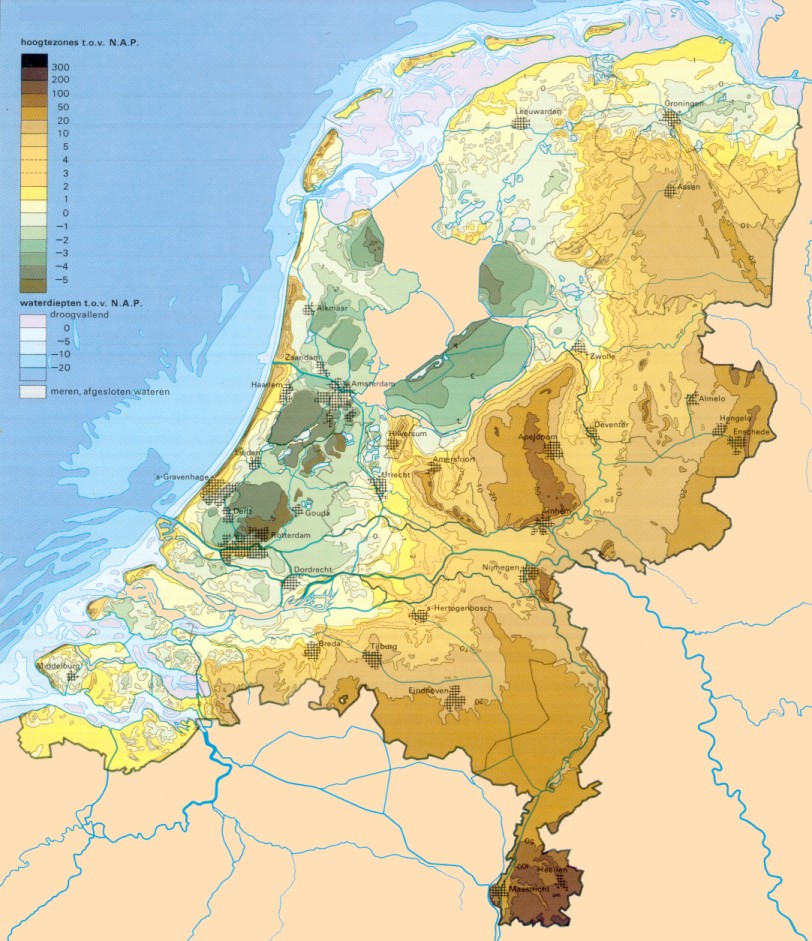
https://en.wikipedia.org/wiki/Grebbe_line#Pantherstellung). The whole system was build to defend the West from the East. From the West the Dutch army can empty the water bassins of the Waterline. After that the following obstacle would be the Grebbeline which the Germans can flood as well...while they are on the western side of it. Once they cross to the other side the faucet is closed and they are in the same position they were in when the Waterline was drained. After that their only option is to withdraw to the other side of the IJssel. The IJssel is a obstacle certainly but shouldn't be any trouble for a force that has probably spend the past year practicing to attack across canals and other waterobstacles. Any German inundation attempts are further hampered (if not made impossible) by the fact that they occupy the part of the Netherlands that is in fact above sealevel
Agree, mostly - they're less a defensive barrier and more a way of limiting the mobility of the Entente forces. The defensive lines were built to take advantage of the terrain though, and that often works both ways (swamps, rivers, etc.).
Well bang goes one particular conspiracy theory. Literally in this case.
")
Well, maybe the one about how he died in OTL. Doubtless ITTL there will be a whole pile of conspiracy theories about it however.
While the Union is connected by Rail to Narvik, my question is whether the colder weather increased the Nordic Snowfall as well, leading to possible blockages.
Unlikely - the reduced temperatures probably aren't going to lead to much more snow.
Another concern is that the Union is still dealing with the Break of Gauge between Sweden and Finland and even with some of the track changed to multiple gauge, until they rip up every rail system in Finland, you still have to deal with change of bogie, which with Coal Cars are going to be pretty stressful. (simply due to weight).
That isn't the reason for the dual tracking - it means you can cross-load between wagons at a large yard with lots of workers available, rather than being forced to change bogies or cross-load at a small town on the border. Given the way railway systems worked at the time, this isn't actually that big a problem, although in the longer run they'll want to go to a unified gauge.
Wait, which Conspiracy Theory?
The various ones to do with Rudolf Hess...
Could the Entente do the reverse of the flooding? Block the IJssel where it splits off from the Rhine Delta as a distributary? (Though the question is why didn't the *Germans* do it to make taking Amsterdam easier)
Realistically, no - it's a massive civil engineering job, and not one you'd want to do in a hurry and potentially under fire.
For the German troops its probably worse. 10km back from the lines it’s the beaten zone for entente arty, 4km say for mortars and MGs. Based on WW1 performance each german army will be losing a regiment a day just bringing up the rations. No AFV to run the last mile at speed. No air cover to keep the spotter planes away. Three rounds from you own guns and they know the CB fire is in the air. Worse for civilian populations if the entente deliberately interdict a particular zone.
Without transport all your ammunition has to come up by hand, and if you change positions it all has to be moved by hand. It take 10-12 hours to dig in a big gun so right now you are in the open during daylight or not moving. The Entente can read a map too they know where the AT guns should be.
I think you're a little pessimistic there - the Germans showed a remarkable ability in OTL to keep fighting under exceptionally difficult circumstances.
The British ( certainly maybe French) practice was to put together a series of divisional and corps level attacks in quick succession to drag german reserves in to a killing zone ( this is 1918 and ww2 btw) unless they are positively ordered to cease all offensive action – which aint going to happen, this is what they wlll do naturally. But its going to be a reinforced mechanised unit with tanks in the lead hitting what is mostly paper this defences with an army of fast powerful mechanised units behind travelling across the the densest road network in the world. Unless a mobile reserve can come up the attack will be 5=10km behind the MLR before Brooke much less OKH understands what’s happening. And the mobile reserve, if it moves within 400mile of the front it’s the target for Entente air forces. By the time it limps its way to its jump off point it will be facing a gunline dug in bore sighted and with the main logistics problem being replacing the barrels after they have been fired smooth ( aka the story of the panzerwaffe in the west 1942-45)
Problem is one of supplies - the road network may be good, but they're an awfully long way from their supply ports and their line of communications is over ground they've recently fought over. Much the same situation as the British and Americans were in late 1944 - they're really struggling to get the petrol and bullets up to the front line to keep attacking, so the orders
will go out to hold in place. This is why shifting the BEF to the Netherlands is so critical - it gives them the ability to move another 100 miles or so forwards, but at the same time they're going to want to make sure they've got the manpower in place to shatter the German line rather than have a series of slow, bloody and inconclusive battles before they do anything.
The Allies don’t need to make a deep penetration, just a series of short ones that shatter the linear front, if the germans move from their current positions they do so at walking pace with what they can pull or carry on their backs, and lose their communication for the most part. The only way they can feed themselves is to take it from the local civilian population. At this point the army becomes a mob moving east into the guns of the allied armour already behind them.
Agreed - but if you can't bring up enough petrol for the tanks to drive forward, or enough shells for the counterbattery you need then the Germans have a soluble problem. Sort the logistics and it becomes an insoluble one.