Map Thread IX

Status
Not open for further replies.
Just a little map showing an 1860 world following the Napoleonic Wars being in Napoleon's favour. It's more suited towards a nation game like setting, so if you would excuse some of the more unlikely things....

If the British lost against Napoleon, why are the borders in North America so much in their favor?
 
Again, did something kinda quick and dirty for the map contest. :( Next time I'm going do something which properly kicks ass...

Bruce

PennsDream.png
 
the world of Anglo-American Rivalry in 1828. butterflies are becoming a bit more apparent now: the borders of the US, Mexico, and Canada are virtually the same as before (the only notable difference being the cession of part of Mexico to become western Louisiana) and will be staying that way for a while. throughout the Americas, former colonial states are gaining independence: only Bolivia and Chile are still under de jure Spanish control, whereas Argentina, Gran Colombia, Brazil, and Peru have all gained independence from Europe, and Paraguay and Uruguay from Brazil/Argentina. colonial influence is growing in Africa and Asia, with the Ottomans exerting their influence in North Africa, the Portuguese in the central regions, and the British in South Africa; virtually the entire Indian Subcontinent is now British, and the Dutch are coming to power in Indonesia. bits and pieces of others states have been gained and lost, such as Qing China, which has lost a few unimportant regions along its southern borders to Indochinese states, and Japan has gained the Ryukyus. Oceania is also coming more under British control, with the official borders of the Swan River and New South Wales colonies in Australia being established, Van Dieman's Land coming under British administration as more than a penal colony, and New Zealand becoming part of New South Wales. non-colonial Africa has changed a bit, but not by much. Europe has been pretty much unchanged since 1816.
Revised Anglo-American Rivalry.png
 
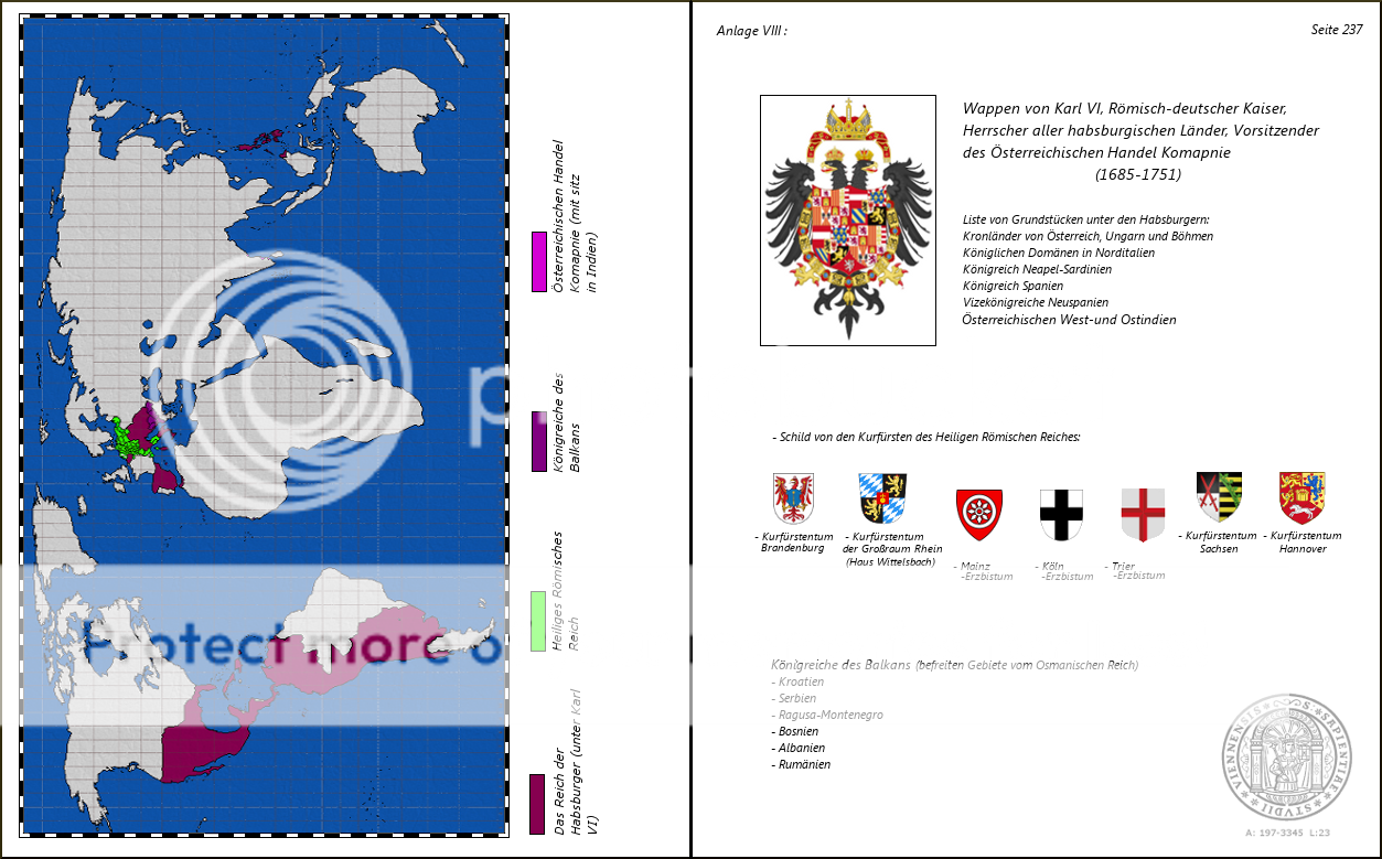
"A pair of appendix pages from a primary school booklet, created by the University of Vienna for outlying schools within the Habsburg Empire, founded when Charles VI won the War of the Crowns against France and Spain for control of the Iberian throne, unifying all Habsburg domains under his, and his descendents, guiding rule"


aus1720334242-2.png

After the latin numbering of kings and emperors there is always a point. So it has to be Karl VI. not Karl VI

Österreichischen Handel Komapnie (mit sitz in Indien) would be
Österreichische Handelskompanie (mit Sitz in Indien). Though it also could be Handelskompagnie oder Handelscompagnie or even Handelscompagny, but those would be really oldfashioned.

(befreiten Gebiete vom Osmanischen Reich) would be (vom Osmanischen Reich befreite Gebiete)

Vorsitzender der Österreichischen Handelskompanie

It should be Besitzungen instead of Grundstücken. "Besitzungen der Habsburger"

Than it is Königliche Domänen not Königlichen. Vizekönigreich instead of Vizekönigreiche (or are there more than one?). Österreichisch West- und Ostindien.

Instead of "Schild von den Kürfürsten..." it is "Wappen der Kurfürsten...".
Last but not least it ist Erzbistum Mainz etc. not the other way round.

Anyway I like your map and the imperial coat of arms looks just great. Did you make the CoA yourself?

Please don't quote maps.
 
I was going to wait and finish Africa and Central Asia and post all of it as one thing, however as those are taking to long I figure I'll just post this instead.

I've left out the borders of the states of the NGF, since it's more a Federation in name only, and what Berlin says goes basicaly.

I started writing a longer description, but by the time I'd finished I realized it was more fitting for a map of 1910, not 1901, so the below description is
pretty short, thus, if you have questions, ask.


In the year 1900 Europe had in many ways come to a sort of stability, the continent had not seen a war in 30 years, the general economic
situation was continually improving and many saw the Great Powers being busy with their overseas Empires or dealing with internal matters
as another safeguard against war, however while many hoped it would, this would not last.

Europe 1900.png
 
I was going to wait and finish Africa and Central Asia and post all of it as one thing, however as those are taking to long I figure I'll just post this instead.

I've left out the borders of the states of the NGF, since it's more a Federation in name only, and what Berlin says goes basicaly.

I started writing a longer description, but by the time I'd finished I realized it was more fitting for a map of 1910, not 1901, so the below description is
pretty short, thus, if you have questions, ask.


In the year 1900 Europe had in many ways come to a sort of stability, the continent had not seen a war in 30 years, the general economic
situation was continually improving and many saw the Great Powers being busy with their overseas Empires or dealing with internal matters
as another safeguard against war, however while many hoped it would, this would not last.

So basically no Franco-German War?
 
So basically no Franco-German War?

No, the PoD's earlier than that, though yes, as of the map France and Prussia (later NGF) never went to war directly, though France did provide aide to the South German states in Prussia's abortive 'Unification War'.
 
After the latin numbering of kings and emperors there is always a point. So it has to be Karl VI. not Karl VI

Österreichischen Handel Komapnie (mit sitz in Indien) would be
Österreichische Handelskompanie (mit Sitz in Indien). Though it also could be Handelskompagnie oder Handelscompagnie or even Handelscompagny, but those would be really oldfashioned.

(befreiten Gebiete vom Osmanischen Reich) would be (vom Osmanischen Reich befreite Gebiete)

Vorsitzender der Österreichischen Handelskompanie

It should be Besitzungen instead of Grundstücken. "Besitzungen der Habsburger"

Than it is Königliche Domänen not Königlichen. Vizekönigreich instead of Vizekönigreiche (or are there more than one?). Österreichisch West- und Ostindien.

Instead of "Schild von den Kürfürsten..." it is "Wappen der Kurfürsten...".
Last but not least it ist Erzbistum Mainz etc. not the other way round.

Anyway I like your map and the imperial coat of arms looks just great. Did you make the CoA yourself?

ill try and change em when i wake up if ive got time..thanks for it though

and the coat of arms is based on charles V, hre., who as you know was the ruler of both branches of the habsburg family so his coat fo arms was the last time all terriotires were joined, although ive changed it subtly to remvoe the old aragonese coat of arms and naples, plus added the bohemian coat of arms in lue of the pommegrante symbol

also combine the austrian and spainish crowns, underneath the austrian version of the hre crown
 
the world of Anglo-American Rivalry in 1828. butterflies are becoming a bit more apparent now: the borders of the US, Mexico, and Canada are virtually the same as before (the only notable difference being the cession of part of Mexico to become western Louisiana) and will be staying that way for a while. throughout the Americas, former colonial states are gaining independence: only Bolivia and Chile are still under de jure Spanish control, whereas Argentina, Gran Colombia, Brazil, and Peru have all gained independence from Europe, and Paraguay and Uruguay from Brazil/Argentina. colonial influence is growing in Africa and Asia, with the Ottomans exerting their influence in North Africa, the Portuguese in the central regions, and the British in South Africa; virtually the entire Indian Subcontinent is now British, and the Dutch are coming to power in Indonesia. bits and pieces of others states have been gained and lost, such as Qing China, which has lost a few unimportant regions along its southern borders to Indochinese states, and Japan has gained the Ryukyus. Oceania is also coming more under British control, with the official borders of the Swan River and New South Wales colonies in Australia being established, Van Dieman's Land coming under British administration as more than a penal colony, and New Zealand becoming part of New South Wales. non-colonial Africa has changed a bit, but not by much. Europe has been pretty much unchanged since 1816.

Just one thing. Please. Give. America. The. Oregon Country! :D
 
I started writing a longer description, but by the time I'd finished I realized it was more fitting for a map of 1910, not 1901, so the below description is pretty short, thus, if you have questions, ask.

How come Galizia is a separate part of the Monarchy while Czechs and Croats are still part of Asutria/Hungary?
 
A simple, somewhat ASB map which is currently a work in progress. The basic gist of it is that the POD is during the Napoleonic Wars (around the time of the creation of the Grand Duchy of Finland), with the nice side effects that the British advocate White immigration to South Africa as soon as the beginning of the Congress of Vienna. Furthermore Prussia gets all the fun stuff, namely Warsaw and Saxony (in exchange for giving up Rhineland-Westphalia). Austria looses Galicia during an earlier 1848-revolution (now the Revolutions of 1841) and later is "partioned" between Prussia, Bavaria and Italy during the 1860s. Russia gets a for me usual wank (followed by a future collapse). In 1827 the southern states secede rather peacefully from the Union.

The Federation of Southern Republics, the Empire of Brazil and the since 1882 independent South Africa are the world's major bad guys (and Russia as well, but at least they abolished serfdom and aren't ultra-racist).

WiP Insasium.png
 
A simple, somewhat ASB map which is currently a work in progress. The basic gist of it is that the POD is during the Napoleonic Wars (around the time of the creation of the Grand Duchy of Finland), with the nice side effects that the British advocate White immigration to South Africa as soon as the beginning of the Congress of Vienna. Furthermore Prussia gets all the fun stuff, namely Warsaw and Saxony (in exchange for giving up Rhineland-Westphalia). Austria looses Galicia during an earlier 1848-revolution (now the Revolutions of 1841) and later is "partioned" between Prussia, Bavaria and Italy during the 1860s. Russia gets a for me usual wank (followed by a future collapse). In 1827 the southern states secede rather peacefully from the Union.

The Federation of Southern Republics, the Empire of Brazil and the since 1882 independent South Africa are the world's major bad guys (and Russia as well, but at least they abolished serfdom and aren't ultra-racist).


I take it the border in the NW USA is suppose to be the Columbia.
 
there were fewer changes from 1828 to 1848 than i thought, so here's the next Anglo-American Rivalry map. this is set immediately after the Treaty of Guadulupe Hidalgo is signed, and therefore immediately after the end of the Mexican-American War. the US has annexed most of Texas, New Mexico, and California as a result; the British were unofficially involved in the war on the side of Mexico, and the butterflies that come from this mean that the US-Mexico border is slightly different now, with the Nueces region and southern California remaining in Mexican hands, and a butterfly of this is that the Gadsden Purchase won't be taking place. the small regions of New Mexico and Alta California that Mexico keeps are transferred into Sonora and Baja California, respectively.

elsewhere, the United Provinces of Central America dissolve into five different states, and British influence in the area via the Mosquito Coast expands a bit. Bolivia and Chile become independent, and Venezuela and Ecuador break off from Colombia. you'll also notice that the borders of some other states in South America are significantly different, namely that Paraguay has those comparatively weird borders and Argentina has more northern territory, as well as a maintaining of Spanish control on the Falklands/Malvinas due to butterflies. British Guyana doesn't exist ITTL, and OTL Guyana/Suriname is instead entirely Dutch.

colonial control is also expanding in Africa, Asia, and Oceania: Australasia is being more properly colonized by the British, and North Borneo has come under British control as well. Portugal's staked a claim in the southern Philippines and northernmost Indonesia, which may lead to some conflict later if and when the US enters the region (since Portugal is closely allied to Britain). Denmark has entered the colonial game and made a claim in West Africa, and--of all countries--Oman is expanding its influence in East Africa. Russia has also fully claimed and explored its borders, getting to more recognizable borders. perhaps most notably, France has invaded and begun to colonize Algeria; the Ottoman Empire is slowly on its way out. Somalia has as-yet maintained its independence, though that could change...or not. Italy is also on the way to unification.

the next map will be set immediately after the Battle of Fort Sumter

Revised Anglo-American Rivalry.png
 
Im working on a Axis wank map, and I want advice on how to make it as realalistic as possible


What changes do I need to make? POD is early Operation Barbarossa and no Italian North African incompetence.

Untitled2.png
 
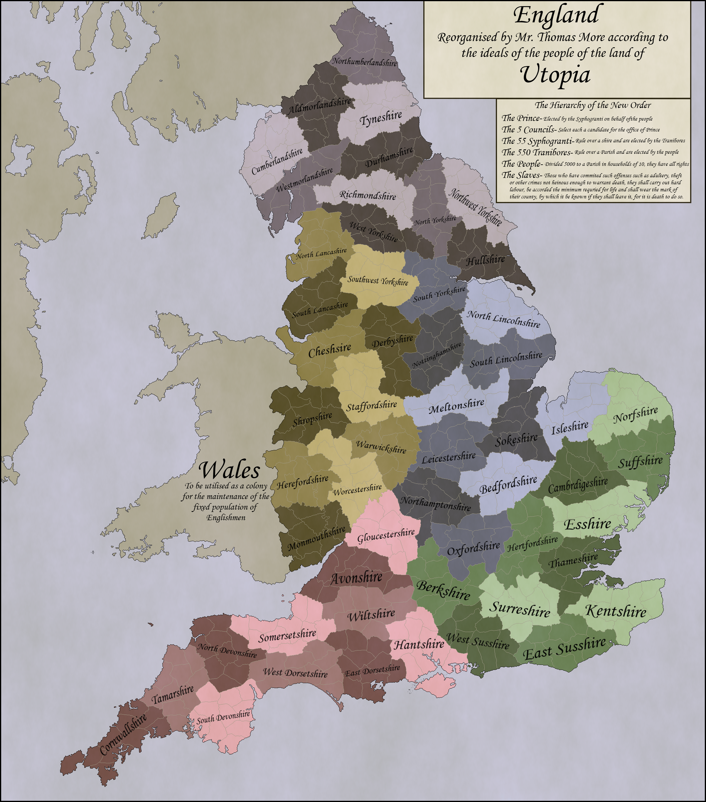
Sir Thomas More's theoretical reorganisation of England along Utopic ideals, much like
the original volume itself, is something of a political caprice, and clearly was not thought of
as the ideal expression of said principles within the land of Britain.

Nonetheless, it is still clear that much of More's opinions on politics can be found within the detail of the idea,
particularly in what appears to modern eyes to be the curiously opposing principles of state supplied healthcare and
education at the Parish level, state supplied higher education and open, well stocked libraries at the shire level
and a current of democracy in the form of elected officials and an elected monarchy throughout the realm,
but with many offenses punishable by a form of slavery in which the individual was not only marked from
his peers in a manner similar to that employed in the Third Reich, but banned from migration
beyond the county of his servitude or from the removal or exchange of said symbols on pain of death.

Women, of course, do not appear to have been given much thought by More, and so we cannot tell
much of their role in this society, asides from the fact that each household of 10 people had an elder woman
who was seen as the equivelent head of the females of the family
as the oldest man was to the males.

motf_54__if_i_ran_the_zoo_by_imperatordeelysium-d4sfmx2.png

Cross posting my MotF entry: Moresian Britian, based entirely on the principles expoused in Utopia!
 
In the year 1715, James III Stuart, after being expelled by Louis XV's court, politely declines the Pope's invitation to go to Rome, and sets for his mother's homeland, the Duchy of Modena.
On the road from Paris to Modena he stops in Valdossola, near the Swiss border. There he discovers a small community of Scotsmen living in the village of Gurro and the nearby valley, that settled there after the Battle of Pavia in 1525.
When the War of Austrian Succession breaks out in 1740, James runs to help the Duchy of Milan, and he is able to expel the Austrians from there.
Later, the Duchies of Modena and Milan get personally united into a new kingdom, that takes the name of Insubria.
The Jackobite kingdom of Insubria is later recognized by George III in exchange for the renounce to any claim to the British throne.
Being now 75 and tired of wars, James accepts.
In the year 1767 Charles Stuart, now called "el bel Carlett'" (Bonny Charley in the local speech) is crowned King Charles I of Insubria.

The Kingdom of Charles I of Insubria, circa 1770:

jackobiteinsubria.png
 
Top
Status
Not open for further replies.
Top