It's a nicely done map.......but one problem. Denmark cannot into Japan.
That meme is really, really annoying and isn't even a legitimate criticism.
It's a nicely done map.......but one problem. Denmark cannot into Japan.
Someone have a good concept for a map? I just can't find one now.
Someone have a good concept for a map? I just can't find one now.

A "Germany wins ww1, loses ww2 scenario?"
Eigenwelt said:Superb thing
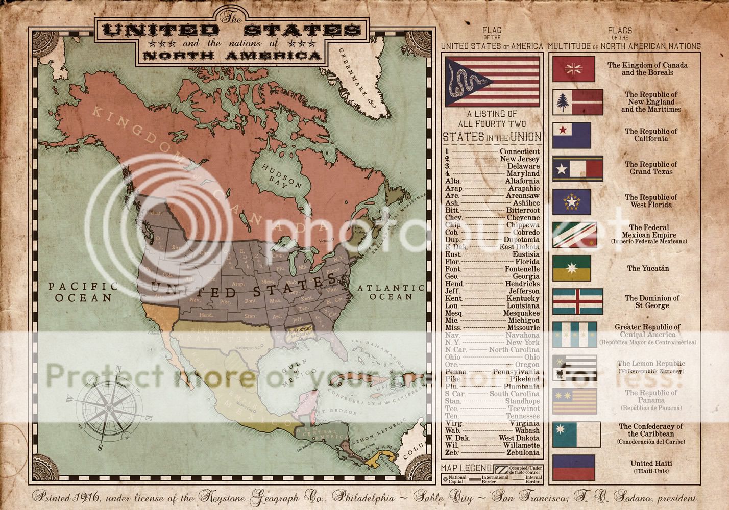
Most of my efforts so far have been with alt timeline flags. This is my first serious attempt at an alt timeline map. The map itself spawned from the US and CAN flags, and grew to include some ideas that have been floating around in my head regarding different western states. The rest of the map developed from a rough brainstorm of the resulting butterflies. Plausibility is not claimed, in fact I wouldn't be surprised if many elements are branded ASB. Only the US internal borders are shown, as in the ATL, this map was produced by and for an American audience.
The POD has not been specifically pin-pointed, ~1812, give or take a few years. The map depicts North America approximately a century later.
The rather bloodless loss of New England in the years following the W.o.1812 left the US somewhat paranoid about further secessions. Instead of the balance of power shifting pro-south, it went anti-slavery much sooner, resulting in a low grade civil war which progressed more as an armed governmental persecution of those who resisted the steady progression of anti-slavery legislation. Die hard slave holders fled to West Florida, as the US government became more militant and paranoid of European intervention in the western hemisphere. During the philosophical and political turmoil following the loss of New England, the new flag was adopted. Weakened in regards to OTL in the first half of the century, it set up Texas and California as aligned buffer states to protect it from an increasingly strong Mexico aligned with Imperial France. By the end of the century the US had turned N.E. from neutral-British aligned to neutral-American aligned, secured the pacific northwest, settled and industrialized the west slightly faster than OTL.
The Kingdom of Canada and the Boreals (the Boreals are the combined name for the NW territories, and the lands west of the continental divide, including OTL Alaska). The royal Canadian family is a cadet branch of the British throne.
Mexico is a Federal Empire, which acts much like an OTL constitutional monarchy. The Emperor is a hereditary title, constitutionally responsible for safeguarding the freedoms of his citizens, and facilitating the cooperation of the federal states. The area under occupation in the north east is controlled by separatist rebels who still consider themselves subjects of the emperor, but not of the federal government. The conflict is currently at a temporary cease fire.
The Yucatan was a republic, but is currently under a progressive military junta.
...and I've run out of time to type before I have to leave for the day. If anyone is curious, just ask and I'll explain what I can given the very sketchy outline I came up with.
And now the map: (this is a small low rez version. the original is 2.5x this size)
We are in the presence of greatness...Most of my efforts so far have been with alt timeline flags. This is my first serious attempt at an alt timeline map. The map itself spawned from the US and CAN flags, and grew to include some ideas that have been floating around in my head regarding different western states. The rest of the map developed from a rough brainstorm of the resulting butterflies. Plausibility is not claimed, in fact I wouldn't be surprised if many elements are branded ASB. Only the US internal borders are shown, as in the ATL, this map was produced by and for an American audience.
The POD has not been specifically pin-pointed, ~1812, give or take a few years. The map depicts North America approximately a century later.
The rather bloodless loss of New England in the years following the W.o.1812 left the US somewhat paranoid about further secessions. Instead of the balance of power shifting pro-south, it went anti-slavery much sooner, resulting in a low grade civil war which progressed more as an armed governmental persecution of those who resisted the steady progression of anti-slavery legislation. Die hard slave holders fled to West Florida, as the US government became more militant and paranoid of European intervention in the western hemisphere. During the philosophical and political turmoil following the loss of New England, the new flag was adopted. Weakened in regards to OTL in the first half of the century, it set up Texas and California as aligned buffer states to protect it from an increasingly strong Mexico aligned with Imperial France. By the end of the century the US had turned N.E. from neutral-British aligned to neutral-American aligned, secured the pacific northwest, settled and industrialized the west slightly faster than OTL.
The Kingdom of Canada and the Boreals (the Boreals are the combined name for the NW territories, and the lands west of the continental divide, including OTL Alaska). The royal Canadian family is a cadet branch of the British throne.
Mexico is a Federal Empire, which acts much like an OTL constitutional monarchy. The Emperor is a hereditary title, constitutionally responsible for safeguarding the freedoms of his citizens, and facilitating the cooperation of the federal states. The area under occupation in the north east is controlled by separatist rebels who still consider themselves subjects of the emperor, but not of the federal government. The conflict is currently at a temporary cease fire.
The Yucatan was a republic, but is currently under a progressive military junta.
...and I've run out of time to type before I have to leave for the day. If anyone is curious, just ask and I'll explain what I can given the very sketchy outline I came up with.
And now the map: (this is a small low rez version. the original is 2.5x this size)]
Most of my efforts so far have been with alt timeline flags. This is my first serious attempt at an alt timeline map. The map itself spawned from the US and CAN flags, and grew to include some ideas that have been floating around in my head regarding different western states. The rest of the map developed from a rough brainstorm of the resulting butterflies. Plausibility is not claimed, in fact I wouldn't be surprised if many elements are branded ASB. Only the US internal borders are shown, as in the ATL, this map was produced by and for an American audience.
The POD has not been specifically pin-pointed, ~1812, give or take a few years. The map depicts North America approximately a century later.
The rather bloodless loss of New England in the years following the W.o.1812 left the US somewhat paranoid about further secessions. Instead of the balance of power shifting pro-south, it went anti-slavery much sooner, resulting in a low grade civil war which progressed more as an armed governmental persecution of those who resisted the steady progression of anti-slavery legislation. Die hard slave holders fled to West Florida, as the US government became more militant and paranoid of European intervention in the western hemisphere. During the philosophical and political turmoil following the loss of New England, the new flag was adopted. Weakened in regards to OTL in the first half of the century, it set up Texas and California as aligned buffer states to protect it from an increasingly strong Mexico aligned with Imperial France. By the end of the century the US had turned N.E. from neutral-British aligned to neutral-American aligned, secured the pacific northwest, settled and industrialized the west slightly faster than OTL.
The Kingdom of Canada and the Boreals (the Boreals are the combined name for the NW territories, and the lands west of the continental divide, including OTL Alaska). The royal Canadian family is a cadet branch of the British throne.
Mexico is a Federal Empire, which acts much like an OTL constitutional monarchy. The Emperor is a hereditary title, constitutionally responsible for safeguarding the freedoms of his citizens, and facilitating the cooperation of the federal states. The area under occupation in the north east is controlled by separatist rebels who still consider themselves subjects of the emperor, but not of the federal government. The conflict is currently at a temporary cease fire.
The Yucatan was a republic, but is currently under a progressive military junta.
...and I've run out of time to type before I have to leave for the day. If anyone is curious, just ask and I'll explain what I can given the very sketchy outline I came up with.
And now the map: (this is a small low rez version. the original is 2.5x this size)
Most of my efforts so far have been with alt timeline flags. This is my first serious attempt at an alt timeline map.
Can someone here point me to a blank map of today where only the borders are drawn, ie. something without colors?
Or even better, can I make a map request?
A fine and beautiful thing
For a first attempt, this is seriously AWESOME. Re Texas, I suggest as a fix that the earlier anti-slavery movement prevents the US from annexing Texas, (it pretty automatically went slave state OTL), which like West Florida would then become a refuge for slave-holders...
Bruce
Most of my efforts so far have been with alt timeline flags. This is my first serious attempt at an alt timeline map.
Most of my efforts so far have been with alt timeline flags. This is my first serious attempt at an alt timeline map. The map itself spawned from the US and CAN flags, and grew to include some ideas that have been floating around in my head regarding different western states. The rest of the map developed from a rough brainstorm of the resulting butterflies. Plausibility is not claimed, in fact I wouldn't be surprised if many elements are branded ASB. Only the US internal borders are shown, as in the ATL, this map was produced by and for an American audience.
The POD has not been specifically pin-pointed, ~1812, give or take a few years. The map depicts North America approximately a century later.
The rather bloodless loss of New England in the years following the W.o.1812 left the US somewhat paranoid about further secessions. Instead of the balance of power shifting pro-south, it went anti-slavery much sooner, resulting in a low grade civil war which progressed more as an armed governmental persecution of those who resisted the steady progression of anti-slavery legislation. Die hard slave holders fled to West Florida, as the US government became more militant and paranoid of European intervention in the western hemisphere. During the philosophical and political turmoil following the loss of New England, the new flag was adopted. Weakened in regards to OTL in the first half of the century, it set up Texas and California as aligned buffer states to protect it from an increasingly strong Mexico aligned with Imperial France. By the end of the century the US had turned N.E. from neutral-British aligned to neutral-American aligned, secured the pacific northwest, settled and industrialized the west slightly faster than OTL.
The Kingdom of Canada and the Boreals (the Boreals are the combined name for the NW territories, and the lands west of the continental divide, including OTL Alaska). The royal Canadian family is a cadet branch of the British throne.
Mexico is a Federal Empire, which acts much like an OTL constitutional monarchy. The Emperor is a hereditary title, constitutionally responsible for safeguarding the freedoms of his citizens, and facilitating the cooperation of the federal states. The area under occupation in the north east is controlled by separatist rebels who still consider themselves subjects of the emperor, but not of the federal government. The conflict is currently at a temporary cease fire.
The Yucatan was a republic, but is currently under a progressive military junta.
...and I've run out of time to type before I have to leave for the day. If anyone is curious, just ask and I'll explain what I can given the very sketchy outline I came up with.
And now the map: (this is a small low rez version. the original is 2.5x this size)
Is Greenmark Scottish or is (Sc) something else? by the way great map.
Well rather rough it is better than many first maps.A map. . .
for any one interested.
A map. . .
for any one interested.