MoF 13: ALL ABOARD! Entries thread

Krall

Banned
Greetings, map-makers! Your Map of the Fortnight challenge this time is:

ALL ABOARD!

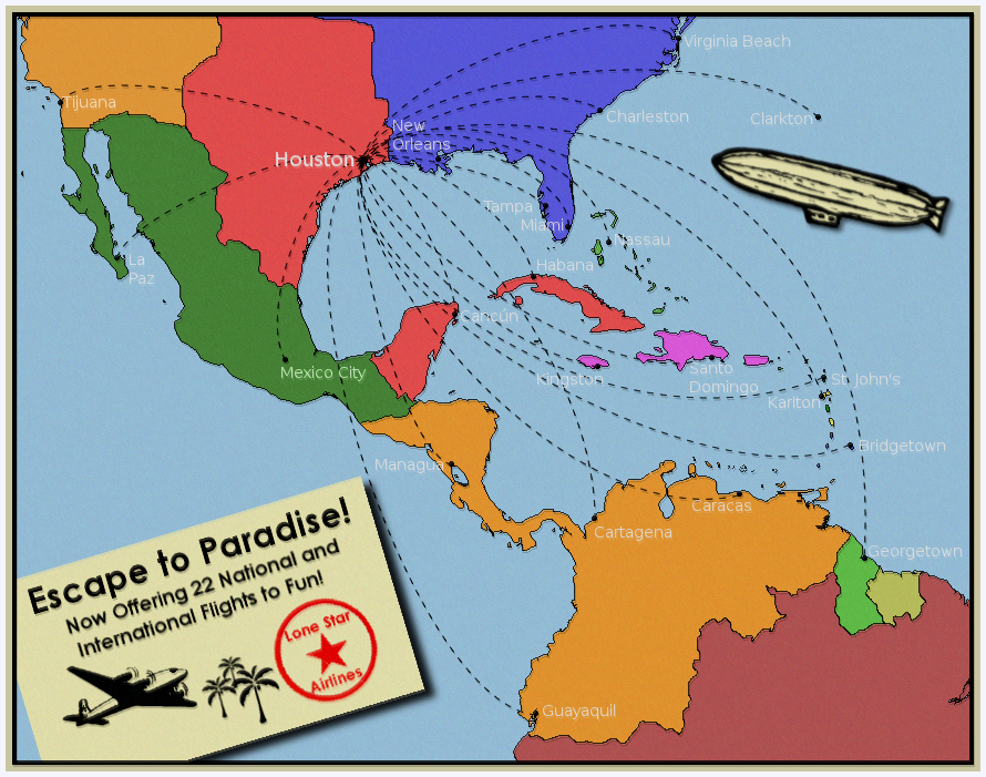
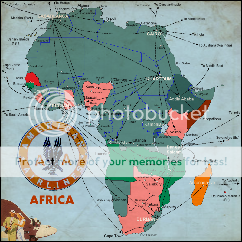
Create a map of an ATL transport network.


This round shall finish on Sunday, 16th of May.

!THIS THREAD IS FOR POSTING OF ENTRIES ONLY!

Any discussion must take place in the discussion thread. If you post anything other than an entry to the contest here you will be disqualified from competing in this round of the contest.


Let the map-making begin!
 
Last edited:
Woo, first post! So this is the North Korean highway system in 1977. The POD is that North Korean forces get advance warning about the landing at Inchon, and the allied surprise attack fails. The UN forces never break out of the Pusan Perimeter, and eventually sign a ceasefire with the North in 1952 after several more failed attempts to break out of the North Korean lines. The rump state, ruled from Pusan, is officially called the Republic of Korea, but in DPRK propaganda it is always referred to as Occupied Korea.

In the years after the war, the DPRK (still called North Korea by the Americans, although it now covers nearly the whole peninsula) builds a system of expressways with Chinese and Soviet assistance, in order to quickly move troops around the country. The Korean War is never officially ended with a peace treaty, only an indefinite ceasefire, and DPRK state media always portrays the ROK as constantly about to attack, so it is important for propaganda (if not military) reasons to be able to quickly move troops to the border. The border itself is a demilitarized zone with large troop concentrations and fortifications on either side. The ROK still has a sizable contingent of American soldiers stationed along the DMZ.

NK.png
 
Last edited:

Penelope

Banned
I decided to go as far-off and dystopic as I could with this one.

This TL which sees the election of George Rockwell, the American Nazi, and the lack of a Highway/Interstate system by the '70s, results in a massive road-bound protest being the basis for a highway system that is completed in the Late-Eighties.

Enjoy!

mof.png

mof.png
 
London Transport Unlimited

This is my first ever map contest entry , so be nice :D

With the election of the liberal government in the great Election of 1932 a new mandate for public transit began. Promising never to close any line anywhere , they pumped millions into the London Transport Executive with the intention of turning it into a showpeice project for the Empire.

Flash forward to the completion of the Javelin high-speed commuter lines in 2009 , and the famous london Transport map now looks like this...

altcu.jpg


(Ok , so that is the fiction , here is the fact. Using MS paint ,ive added every closed route , line and station back onto the LT map. Then ive added every proposed line , extension and station. After that I threw in some of the Light rail lines that were in vouge a few years ago. Finally ive thrown a few "jokers" into the pack , and a shiney penny to those that can find the "Secret" station.)
 
With the British refusing to allow major Jewish settlement in the Palestine Mandate the Territorialists became the dominant force in Zionism,
leading to the Jewish state of New Israel being created in what was East Prussia following the end of WWII.

With investment from the Marshall plan and the building of a diverse economy New Israel has, among other things, developed a robust,
developed and avanced transportation system.
.
.
.
.
.

Transit Map.png
 
When a conflict weary Barsoom finally hammered out what all hoped would be a lasting peace it was realised that some form of organisation would be required not only to maintain the peace but also to reconstruct and develop the planet. So was created the Barsoom Trepcafate (‘BT’), an all powerful council of 195 elected Trepcafs who in turn elected the Mepsunicrol as the chief executive.

One of the projects started in the 18th year of the BT was the creation of a planet-wide overground transport system based upon the Atmostube, a series of airtight tubes within which sealed carriages are propelled at high speed by an alternating vacuum/air system. The ageing Atmosphere Factory was in dire need of upgrading and this was undertaken with the projected needs of the Atmostube System (known as ‘BATS’ from Barsoom Atmostube Transport System). As can be seen from the attached map, by 45 BT the major traditional and new cities were connected by the BATS.

ah map barsoom 0p.png
 
The Commonwealth of Oceanica was formed in 1902, originally consisting out of the continent of Australia, the island of Van Diemen's Land, the two islands of New Zealand, as well as the south-eastern part of New Guinea, with the capital city being Sydney. In 1932 the Oceanica State Aeroplane Society (also known as OSAS) was founded to develop and test airplanes in the Australian Outback, which after World War II became the OSAS was bought by a private investor, who made renamed the company to Oceanican Airlines, which became the most important airline in the Southern Pacific. The shown poster, which was printed in 1996, shows the most prominent internal airports, centered around the Sydney hub, as well as the international designations.

oceanica.PNG
 
Last edited:
A little something inspired by some maps in this thread and a farsighted look at the Ameriwank universe in the late 50's early 60's...

Africa1950isha2.png
 
Top