You are using an out of date browser. It may not display this or other websites correctly.
You should upgrade or use an alternative browser.
You should upgrade or use an alternative browser.
Map Thread VI
- Thread starter Ian the Admin
- Start date
- Status
- Not open for further replies.
Well, we had an Irish-wank in celebration of St. Patrick's day, and I was inspired: being kinda busy and not Swifty McFast, I only finished today, alas.
This comes from a somewhat ASB alternate history, The Silent Stars Go By, by James White, better known to SF affictionadoes as the writer of the "Sector General" galactic hospital novels. In it, Hero's steam engines gets wider distribution, and ends up being turned into a practical invention by the early Medieval Irish, of all people. Meanwhile, St. Brendan succeeds in making friendly contact with native Americans...
Moving forward to the year 1492, we find a world in fact rather more technologically advanced than our own: indeed, the world's first (slower than light) starship has just been launched, an international effort. The Irish have colonized and Christianized much of the planet, but have generally taken a rather less brutal approach in dealing with native Americans than OTL Europeans (perhaps due to initial low numbers). The Federation of Redman Nations (yes, I know. Blame White) has considerable autonomy within the empire, as do the Saxons (Christianized here by the Irish: the Holy Roman Empire never really got off the ground here).
Ireland's long technological lead is finally coming to an end, as western Europe, East Asia, and the middle East catch up technologically. Its colonies, mandates, dependencies, etc. are getting restless and politically savvy, and it looks like the Empire will either have to let a lot go or find a way to bind Africans and Indians and Mesoamericans to the gaelic center the way they managed to do with the Amerindian tribes of the north American interior.
I assumed that Islam failed to rise in this world: there was a mention in the book of Muslims, but for all the difference it made to the story they could have been Unitarians. There was a great medieval Arab empire, but it did not bring a new religion, although it guaranteed that the Monophysite position prevailed in the Middle East rather than the Chalcedonian creed. Nestorianism is confined to Persia, while the Turks follow a form of Manicheanism. Most of the Irish Empire (outside still mostly Hindu India) and the major states of Western Europe follow a tolerant form of Catholicism, the states from Avaria (mostly Slavic nowadays) to Armenia look to the Patriarch in Constantinople, while the 'Teuton' (Germans) states, the Pomeranians, the Polesians, and Littorn-Rus follow a more conservative breakaway form of Catholicism). Buddhism did better in south Asia, and the important mid-sized states of Kediri 'Indonesia' and the Punjab are both Buddhist states.
South america, neglected for some time after the initial Irish colonization of North America, is a bit backwards. Native American states survive in the Andes, and the more successfully modernizing Chimu empire has expanded at the expense of the Tihuanaco Empire to it's south.
Mesopotamia, the world's largest producer of petroleum products, is rich, easygoing, and has never produced a suicide bomber.
North America is complex: there is a lot of Native American blood in the parts which are core Imperial territories, but the "Redman" states have a lot of European blood, and use Irish as a common language which increasingly displaces the various local tongues. And then there are the Scandinavians in the northeast...
St. Brendan's Isle (OTL Manhattan) where according to legend he first met to confab and preach with the local chieftans, is a self-governing "free city" of Empire, a great center of devotion and pilgrimage, and in-season choked with tourists.
The Empire and its associated states (Gaul and Iberia, although not part of the Empire proper, have been for a long time economically symbiotic with it) form the largest economic zone in the world and the center of its most advanced technology, but it is deeply worried about the Cathayans. Defeated in a war with Nippon and its Turkish ally thanks to the unforgiveable rudeness of the Japanese in duplicating Irish nuclear weapons first, forced to give independence to rebellious Viet and Hugoguryeo, for six decades the Cathayans have prepared for a rematch, until the atomic arsenals of the rivals has reached OTL 1980's "wipe out the northern hemisphere" levels. The ship now launched to the stars is more than a Triumph of the Human Spirit: it also may be a lifeboat.
Bruce
Nice alt-borders in North America, although I'm not sure about the Canadian-Mexican border. When's the PoD meant to be? as some things like Moldova and Transnistria seem unlikely with such an early PoD as the rest of the map seems to require.
For the Canadian-Mexican Border, the POD is 1846-1847 after the Mexican-American War. The Western British Empire, with its primary goal of keeping a check on American expansionism supported Mexico in the war. Also around this time, there were still territorial disputes between the Western British Empire(specifically Canada) and America due to a far more aggressive Canada/WBE that was expanding in the 1830's. With several major forts and canals built and with Britain and many other colonies backing them up, the WBE took a chance and went to war with America on the side of Mexico.
The aftermath of the war finally settled the Canadian/American territorial disputes which is what Canada wanted. America was repayed for some damages and had all prisoners returned and was given time and resources to resettle those in the disputed areas who did not wish to be under the Western British Empire. Mexico did lose a large chunk of Texas but not nearly as much in OTL. To ensure something like that never happened again, they attempted to rapidly settle the remaining northern territories. The Western British Empire, along with financial help from the Eastern British Empire, offered to buy a large swath of the Alta California territory from Mexico which would help Mexico pay off its war debt and not have so much ground to cover. The plus side for the British Empires was more land to settle with Empire Loyalists, valuable resources and a very good port city.
As for Moldova/Transnistria, well, I dunno yet. I just have a soft spot for Transnistria.

I'll come up with something soon enough.
I'll bite. The beauty of using a large base map is that you can put a lot of information in. However here you have not used labels, capital cities, etc. The same map could have been done using the smaller world base map.
The idea has merit, but as it is the map is bland. Look at Alex Richards map. It uses a portion of the same base map as yours, but contains plenty of information.
To be honest, I'm not very good at making info blocks like that. I've slowly gotten a BIT better, but it's still embarassing.
Thande
Donor
And here's der map.
Bruce
Now, that - that is a Hibernowank
I am slightly familiar with the book in question, and regard it as crazy-awesome rather than silly. Especially since I'm a sucker for the St Brendan legend (Tolkien wrote a long poem about it which I believe Scarecrow referenced in one of his timelines).
Alright, this took longer to do than I thought it would, but anyways.
From my current TL;
In the last years of the 19th century, with the world having been 'thoroughly explored' groups in Britain and the Ottoman Empire looked
South towards the great unexplored Southern Pole.
In 1895 the British and Ottoman governments, having close relations at the time outfitted and funded one expedition each, with the two
expeditions in a friendly race to see who could reach Antarctica first.
After a long and sometimes harrowing trip* the expeditions crossed the arctic circle at roughly the same time.
In the end it would be the Ottoman expedition that would win the competition, reaching land a mere hour and a half before the
British expedition landed.
The British and Ottomans officially laid claim to parts of Antarctica in 1907, backing each others claims.
In 1914 France laid claim to a large part of Antarctica, part of which conflicted with the British claim.
In 1916 the United States, for varying reasons, laid claim to a part of Antarctica, establishing formal claim borders with Britain
(who ceded some of their claim) in return for supporting Britain over France in the 'claim war'**.
In 1923 the Expedición Península was undertaken by Chile leading to Chile making a claim to the Antarctic peninsula, quickly backed
by the United States.
In 1927, after sending an expedition of its own, and with the support and encouragement of Chile and the U.S. Argentina laid claim
to Antártida Argentina.
In 1938 France came to an agreement on formal claim borders.
Following full independence sovereignty over parts of British Antarctica closest to them were transferred to South Africa, Australia
and New Zealand, while the U.K. itself retained the 'Mid-Atlantic Antarctic'.
Notes:
1. The 'movie of the decade' of the 2000's was based on the expeditions.
2. Not an actual war, but the whole situation became a popular topic of discussion at the time.
In the Timeline that I am writing in the Future History section, The United States is substantially larger. There are a total of 65 states, with 8 of them being named after the Founding Fathers (Excluding Patrick Henry, who was not considered to be a one of these elites for unknown reasons). In addition, several State's names have been changed (New Mexico = Navajo, North Dakota = Lakota, etc.) while other locations are now full fledged States.
Earth still has hundreds of independent countries. However, the UN collapsed during the War of Armageddon (aka WWIII), which was the first time that combat occured outside the cradle that is Humanities home planet. Planetary Colonization soon followed. And then the Colonial Space Command became the new version of the UN. On Earth, countries have no governing body with which they must obey or face severe punishment. However, the world's most powerful nations (or those that are considered to be) Form the backbone of the Colonial Space Command, which itself, serves as an independent nation not confined to the boundaries of Earth.
Here is this timeline's United States. 65 states, some of the borders are exceptionally crude. In particular, the Purple mass in the Southwest. (Navajo, Apache, Comanche, one of the Founding Father states [Jay?]) all have unbeliveably horrid borders with one another (and Texas) But without good references, i couldn't make it look too much better.
Simple key:
Red - Republican States
Blue - Democratic States
Yellow - Independent states
Purple - Voting preference swaps nearly every decade.
Yes, some were. Most however came from all over the world, but the Chinese did give them most of the funding to launch their ship.Very creative! Where the Rememberers originally from China? - just 'cos some of the names sound Chinese.
@B_Munro: Excellent map again, but what's going on in Africa? It doesn't really get much mention.
Alex Richards
Donor
Interesting concept and great map. However, all of Canada is preserved in 1984 as a part of Oceania. Gotta love Britain.
Great job though.
As I said, it's about 2 years before the actual formation of Oceania. This is sort of a mid-way step between the puppetisation of the British Empire and its actual annexation.
Highlander
Banned
Steampunk inspired little timeline I have cooking.
Take note of the general lack of skyports in the South, except for Texas, which has a good bit of autonomy.
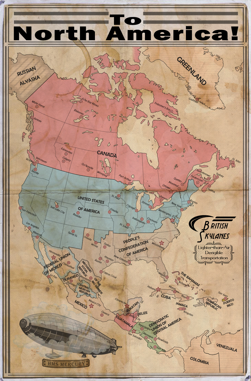
Take note of the general lack of skyports in the South, except for Texas, which has a good bit of autonomy.
There must be some winterizing on those balloons for them to fly that far north, either that or they are seasonal routes.
Excellent map as always.
Excellent map as always.
As I said, it's about 2 years before the actual formation of Oceania. This is sort of a mid-way step between the puppetisation of the British Empire and its actual annexation.
Ah, I see. That's why I was a bit confused. Still, great job.
Great map as aways Highlander and I love the idea of a communist CSA. One question why has Haiti puppeted Yukatan?Steampunk inspired little timeline I have cooking.
Take note of the general lack of skyports in the South, except for Texas, which has a good bit of autonomy.
Steampunk inspired little timeline I have cooking.
Take note of the general lack of skyports in the South, except for Texas, which has a good bit of autonomy.
You missed naming Haiti, unless it is part of the Confederation...hard to tell.
Highlander
Banned
Yes Haiti is a PCA "State" - actually a Mechanical Democratic Republic, like several others.
Okay, so, here's a sectional map of my Western British Empire in 1901 with some basic info and an incredibly brief history with major events. Similar maps will follow for the Eastern British Empire, Portuguese Empire, Dutch Empire, etc.


This map was painted for my friend's story - "Leader of the Yugoslav state". There was a Nicola Tesla as Yugoslav leader. This map is dating 1940-s. There is a war between Teslofaschist powers (Yugoslavia, Italy, Albania, England) and Ctulhists (China, Russia, Germany, France). And there is a civil war in Spain.

- Status
- Not open for further replies.
Share: