I'm sure at some point it will resurface by someone.
Shhhhh... don't give them any ideas.
 Maybe I'll give WWIII a try as a slideshow that was suggested earlier, but only using European maps.
I'm sure at some point it will resurface by someone.
Maybe I'll give WWIII a try as a slideshow that was suggested earlier, but only using European maps.This map is actually a heavily modified version of a 'Guess The Wank' game I found posted on here from ages ago. I was amazed to find that, when similar colours were assumed to indicate the same power, the end result actually looked fairly plausible (leaving aside odd elements like uninhabited coastline and landlocked colonies), and in fact had less ridiculous uberpowers than OTL!
However, it's a good idea to put your explanatory text in a separate post to the map itself, as otherwise it word wraps in such a way that people have to tediously scroll back and forth to read your text.
This map is actually a heavily modified version of a 'Guess The Wank' game I found posted on here from ages ago. I was amazed to find that, when similar colours were assumed to indicate the same power, the end result actually looked fairly plausible (leaving aside odd elements like uninhabited coastline and landlocked colonies), and in fact had less ridiculous uberpowers than OTL!
Accordingly, I decided to attempt a fully annotated map for the setting with a vaguely plausible invented P.O.D. (no War of the Spanish Succession due to a new and distinctly less inbred Charles II delivered in a warming pan). Italy is united under Venice, France holds onto western Louisiana (then splits into two metropolitan Frances in a delayed action super-Revolution), and Russian goes radical (TTL Communist) then gets a Czarist Restoration. Hopefully there's enough flavour text on the map itself to give a good idea of how things are shaping up between the monarchist and radical powers.
Very fine map and a good original use of a somewhat overused basemap which makes it look better. However, it's a good idea to put your explanatory text in a separate post to the map itself, as otherwise it word wraps in such a way that people have to tediously scroll back and forth to read your text.
I have'nt read every part of the map, but it is interesting, and as Thande said a good alteration to an overused basemap.
Thanks! Rather than try to remove the map and post it again after the comments people have posted, I've followed Iori's suggestion and manually wrapped the text in the post.
Lord Roem - Thanks! The font is actually Batang - I was going for something unobtrusive that looked reasonably modern and typewriterish, but I've just noticed it does look a LOT like TNR. I tried a more swirly font but coupled with the dusty colours it made it look too medieval. I was a little concerned I'd gone overboard with changing the borders - admittedly, no Treaty of Utrecht is going to mess things up, but still. There are a few borders that made me cringe a bit - namely Germany and the Royal Netherlands/Regal Belgium appear attracted by destiny to the same bits of Africa as OTL, but it was intended to be principally a tribute to the 'Find A Wank' map, so I shouldn't complain.
Seeing as I haven't posted a map in some time...
Nice!
I'm always a stickler for the "alternate textbook" look regarding maps. How did this analogy for the Ottoman Empire come about?
Awesome, although the treatment of Africa kind of has a space-filling-and-what-else feel to it, especially compared to the (I must say) quite detailed depiction of SE Asia and Australasia.MAP.
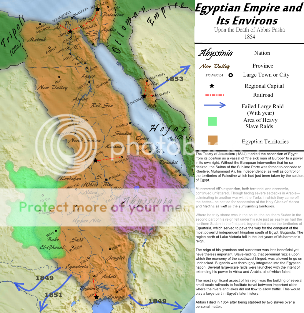
Awesome, but how useful could the Mengo-Gulu railroad be? I confess I don't know much about East Africa, but it looks like there's several lakes and rivers nearby which could serve decent transport purposes. How much freight would there be that far south and that far inland, too?MAP.
Interesting..but was the name of Pepperland just a set up for the Beatles pun?Just starting to experiment with GIMP-- blurs, textures, and fiddling around with paths. The map's hardly a serious TL, mind.
POD is a surviving Roanoke colony. With English manpower low and Indian support seeming spotty, Sir Walter Raleigh engages in an advertisement and public relations blitz in England proper in an attempt to lure in more voluntary colonists. As part of the ad campaign, Raleigh rechristens the Virginia colony with a more alluring name, evocative of the riches of the Orient.
Although Queen Elizabeth was personally displeased with the name change, "Pepperland" becomes a smashing success, drawing in many Englishmen (and -women) searching for riches, adventure, or just a decent spot of land for themselves.
Pepperland does not develop without its own troubles, though. After the French seizure of the New Netherlands in 1633, it became apparent that the Bourbon kings of France had designs on the whole of North America. Colonial wars flashed every few decades for centuries, culminating in the 1864-69 Colonial War (which coincided with British intervention in the Franco-Saxon War on the Continent), which very nearly marked the end of British Pepperland. Although Pepperlanders celebrated the defeat of the northern "Blue-coated meanies" of New France (and marked the occassion with the creation of their own military-themed national personification, Sgt. Pepper), it would not be the last time Frenchmen would despoil the territories of Pepperland...
This map is actually a heavily modified version of a 'Guess The Wank' game I found posted on here from ages ago. I was amazed to find that,
when similar colours were assumed to indicate the same power, the end result actually looked fairly plausible (leaving aside odd elements like
uninhabited coastline and landlocked colonies), and in fact had less ridiculous uberpowers than OTL!
Kind of. I wanted to do a Beatles-themed map, and I wanted to do another North America map just 'cos I've been on a roll working on a few other things, I've been reading up on the Dutch East Indies and the pursuit of the Spice Trade, and everything just seemed to roll together nicely.Interesting..but was the name of Pepperland just a set up for the Beatles pun?
Seeing as I haven't posted a map in some time...
,
The Pepperlanders are known for their great strawberry orchards that George Starkey would describe in the nationalist anthem as "Strawberry Fields forever"Stick another Beatles reference in there, I dare you.
Cool map though.
Awesome, although the treatment of Africa kind of has a space-filling-and-what-else feel to it, especially compared to the (I must say) quite detailed depiction of SE Asia and Australasia.
Awesome, but how useful could the Mengo-Gulu railroad be? I confess I don't know much about East Africa, but it looks like there's several lakes and rivers nearby which could serve decent transport purposes. How much freight would there be that far south and that far inland, too?
SReagan, Rex - very nice maps. Congrats!
I really like this one. Well done!
.. Maybe their disembodied souls had a philosophical debate ironically amongst the USSR?