My latest LTTW map:

Wait, is that a Portuguese Mataram?
Anyway - Dieselpunk fantasy map!!!

My latest LTTW map:
Excuse me, I have to write an epic saga of novels based on that epic map now.
Wait, is that a Portuguese Mataram?
Anyway - Dieselpunk fantasy map!!!
A second map using my fantasy base map? Wow, I guess I did a good job there.
Wait, is that a Portuguese Mataram?
Anyway - Dieselpunk fantasy map!!!
Wait, is that a Portuguese Mataram?
Anyway - Dieselpunk fantasy map!!!
)EDIT: Kingdom of Rhovanion?? I know Tolkien used Slavic words for a lot of the stuff pertaining to Wilderland but...
Anyway - Dieselpunk fantasy map!!!
Wait, is that a Portuguese Mataram?
Anyway - Dieselpunk fantasy map!!!
Very interesting map. I'm especially curious about the Georgia/Florida Situation. So, I hope you don't mind me guessing about it.
So I assume for Georgia that the Situation was very similar to 1992 Election were Ross Perot divided the Republican vote. Also, I would assume Mormonphobic voters would further divide the vote, thus winning Hillary the State that Bill won 16 years earlier. Is this what you had in mind, or was I dead wrong?
It looks like "Great Britain (Magnificently Isolated)" was added to the map on top of correction fluid.1848 goes better. Don't worry, Susano, the forces of reaction will lose in the end and Germany will be united eventually...
Bruce
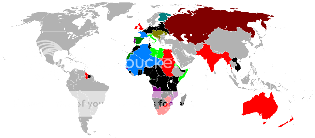
Here's something I did,a really basic map. Of what the New World might look like if European Empires still controled it.. to keep things easy..present day boarders are kept.
Purple-Russian Empire
Pink- British Empire
Yellow- Spanish Empire
Lime Green- Portugese Empire
Gray- French Empire
Red- Japanese Empire
Brown- Norwegian Empire
I based this on a game of President Forever 2008.
Gravel got around eight to ten percent or more (I didn't check) in Georgia. This screwed up the vote potentially, and although religion isn't taken into account in the game, I'd guess that there would be some Mormophobia.
Doesn't explain though, why the hell Romney won typically "blue" states like Washington, Oregon, and Pennsylvania. Maybe because he's left on a lot of issues.
I'm working on a 2012 scenario, with Ron Paul as the Libertarian candidate.
Dark Grey= initial territory & territory gained via conquest;
Light Grey= territory acquired via diplomatic annexations;
Dark Red= vassals;
Red= vassal conquered territory.
to keep things easy..present day boarders are kept.
Coloring the names still isn't as useful or attractive as putting the key in the image.Purple-Russian Empire
Pink- British Empire
Yellow- Spanish Empire
Lime Green- Portugese Empire
Gray- French Empire
Red- Japanese Empire
Brown- Norwegian Empire
He also gave Brazil French Guiana and France Suriname.Interesting, but you've drastically inflated Brazil. It reaches to the fringes of the Bolivian Plateau, which was decidedly Spanish and very hard to reach through the Amazon, abnd has for some reason taken over the equally Spanish Plata mouth, which makes the Spanish possesion of Patagonia logistically bizarre.
