X-posting my speed-cartography MotF entry:
Historically, wasn't Bolivia known as Upper Peru?
X-posting my speed-cartography MotF entry:
Historically, wasn't Bolivia known as Upper Peru?
Historically, wasn't Bolivia known as Upper Peru?

Inspired by Upvote's 20-minute speed cartography, I decided to do some speed cartography of my own. Of course, me being me and Upvote being Upvote means that mine took not 20 minutes, but 4-5 hours. (Also, I may or may not have made this map entirely for the Monty Python reference, which is certainly in keeping with the current contest.)
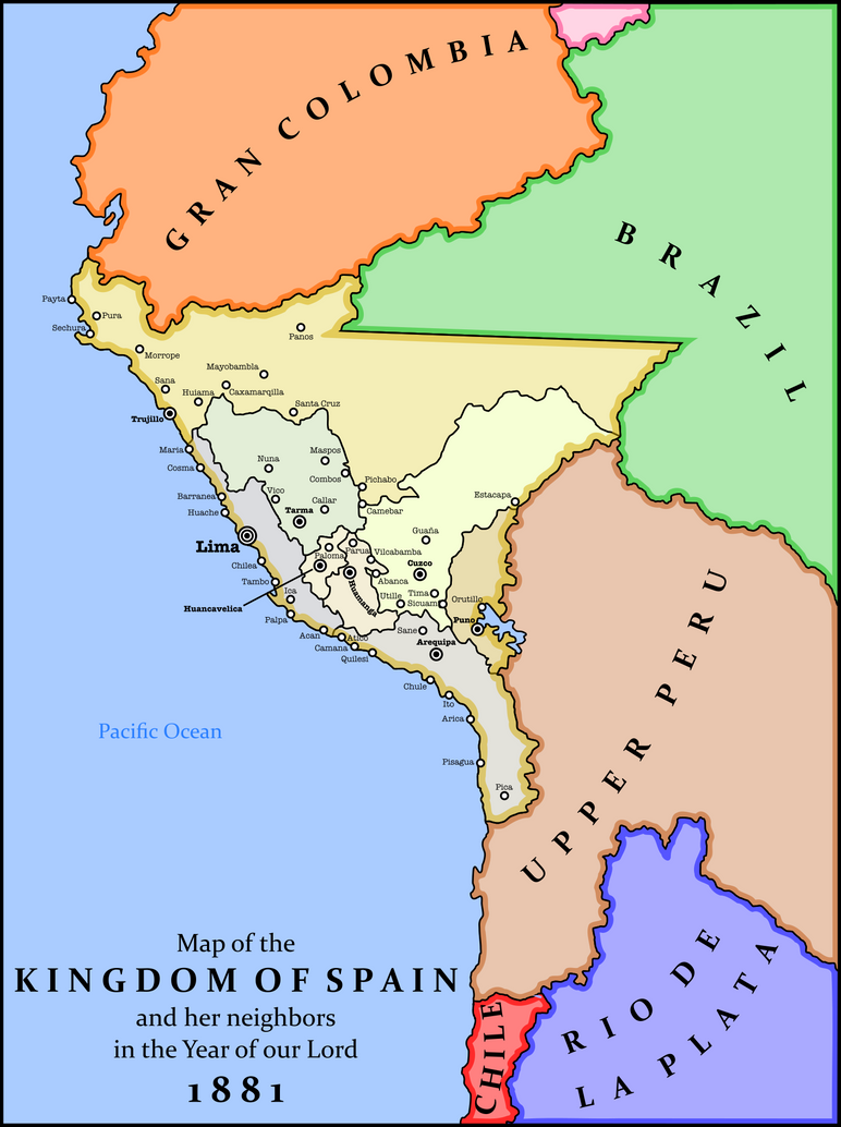
The basic premise is that the Spanish king is dethroned during a different, French Republic-centered, Napoleonic Wars, making Spain into a Republic (of sorts) and causing what was left of the Spanish royal family to flee to their American colonies. However, most of the rebellions go off on schedule, and the TTL Spanish overlords are even less equipped to fight them than the OTL ones. The Royal Family is slaughtered in their beds after the King refuses to flee Bogotá, seeing it as a sign of weakness. However, the Peruvian ruling class, searching for something, anything to unite the lower classes behind them in preserving the old systems and battling the rebel armies all around them, smuggles a precious treasure out of the burning city: the infant who would later become Carlos V of Spain. With this powerful symbol to rally behind, the Peruvians secured their borders and became officially the last piece of land held by the Kingdom of Spain. Today, the Kingdom is effectively ruled by an oligarchical upper class, with the King essentially powerless in the face of their resources.
Me too, should we do a Tuva-wank?
) I played over the summer as Silesia. This is very silly, obviously, and a lot of the provinces I made up or are utterly ahistorical. (Like, with a POD of 1444, New Silesia probably wouldn't exist. And Sudeten wouldn't be named that.) Also, I used German because 1). It's a fun language for fun people and 2). I didn't want to decide on whether to use English names, Polish names, or Czech names. 

Partition of British India
Is there a larger version? I can't make out what's written under Republic of Bengala or what's in the top left there. Also, it should be "Partition" rather than "Parition" in the title and "Republic of India" rather than "Republic of Inida" in the main text box.
Thank you
Updated it so that is larger.
The writing in the Kashmir area is just mentioning that region is disputed between Kashmir and Pakistan. I didn't want to make it even larger as it can be an annoyance some people when a large image pops up.


Can I steal that base map?
Can I steal that base map?
Crossposted from my timeline, Qilai, Qilai! This is as of mid-2003, shortly before the Islamic Caliphate invaded Jordan and began to pummel Israel.
.
Interesting. Chad, though, seems a bit iffy as a member of the Islamic block. I know that it's absence would break up the neat geographic contiguity you have there, but it's nearly 50% non-Muslim and its Muslim communities aren't really notably militant. Why not throw in an Islamicist north Nigeria instead? The British didn't have to let the place go as a single state, after all.
(And that color is more reddish-tan than orange).
Alright, fixed it: