some states are a tad convergent, but overall a very nice map. I see you're working with vectors. Pretty. Also, interesting that El Paso exists under the same name. I imagine it would still exist given the border, but maybe not by the same name? Nord Huarez or named after a person or family that funded its settlement might work?Here's a rough and quick look at Louisiana in the FNM-verse:

You are using an out of date browser. It may not display this or other websites correctly.
You should upgrade or use an alternative browser.
You should upgrade or use an alternative browser.
Map Thread XX
- Thread starter Balkanized U.S.A
- Start date
- Status
- Not open for further replies.

A tremendously ASB map from the TL of my NationStates region Pax Britannia (https://www.nationstates.net/region=pax_britannia). Broadly a mega Hungary (who avoided obliteration by the Ottomans thanks to a surviving Byzantinium) who now dominates the Carpathian Basin/Balkans and integrated them into the so-called Jagiellonian Union. Jagiellonia (Hungary) also picked up a few colonies over the years, most prominently Libya, but also a chunk of the Levant, a bit of OTL Gabon, Cabinda, and Walvis Bay in Namibia.
The nation is a unitary state dominated by the Hungarians in Buda, much to the chagrin of the union's lesser minorities. The government is a one-party state led by Palatine Laszlo Bardossy (https://en.wikipedia.org/wiki/László_Bárdossy), with a consitiutional monarchy. The royal dynasty is the house of Zapoyla, but they kept the heritage of the extinct-Jagiellonian Dynasty.
So yeah I guess a Hungary wank.
Real nice. However, I feel that you could've switched the first and third boxes on the right. That way the Levant colony would be 'framed' which would look cool.
I also feel like Cyprus is missing - I think it would poke out from behind the box, no?
Great map regardless.
Northstar
The town and the name El Paso del Norte, meaning "pass of the north" and signifying the fact that around there is where the Río Grande makes its way through a mountain pass, dates all the way back to 1659, and dropping the "del Norte" off the end (and then, in this case, translating it to French) is the logical thing to do after the border shifts and it's no longer in the north of its country.some states are a tad convergent, but overall a very nice map. I see you're working with vectors. Pretty. Also, interesting that El Paso exists under the same name. I imagine it would still exist given the border, but maybe not by the same name? Nord Huarez or named after a person or family that funded its settlement might work?
(Also, this isn't targeted against you specifically, but I'm always bewildered by the degree to which people are willing to cry convergence for things like river and drainage basin borders, which exist in the natural word and so could very rationally be reused by people in alternate timelines, because they're good, clear borders and all...)
Last edited:
tukaram bhakt
Banned
Mind blowing!
Sites and Settlements of Tsalaguwetiyi, the old Cherokee Country
~
Here is a recently completed map of Cherokee towns and place names; this one took longer for me to make because it took a while to figure out Cherokee, and finding reliable sources on the towns is a whole different can of worms. Please do keep in mind that I am not a Cherokee language expert, and some sites may be in the wrong place, but that's something one has to deal with when theres five maps with a town in different locations, I suppose. The ones that are on the map are ones who have a precise location in sources; there're many towns that sadly don't have any info next to their name other than something like what year they were razed.
Incidentally, this is also my first map with something created in QGIS, the topography layer in the background. Looking closely, you can see there are rivers that don't quite match the rivershed in the topography, and that's because I used a basemap with a bit of warping for the rivers layer. I'll have to get better at reprojection in QGIS and choosing more modern basemaps next time.
So hopefully this map sheds some light onto the extent of the Cherokee nation. I've always been interested in aboriginal names in any country, so expect maps with the same premise as this one in the future as well.
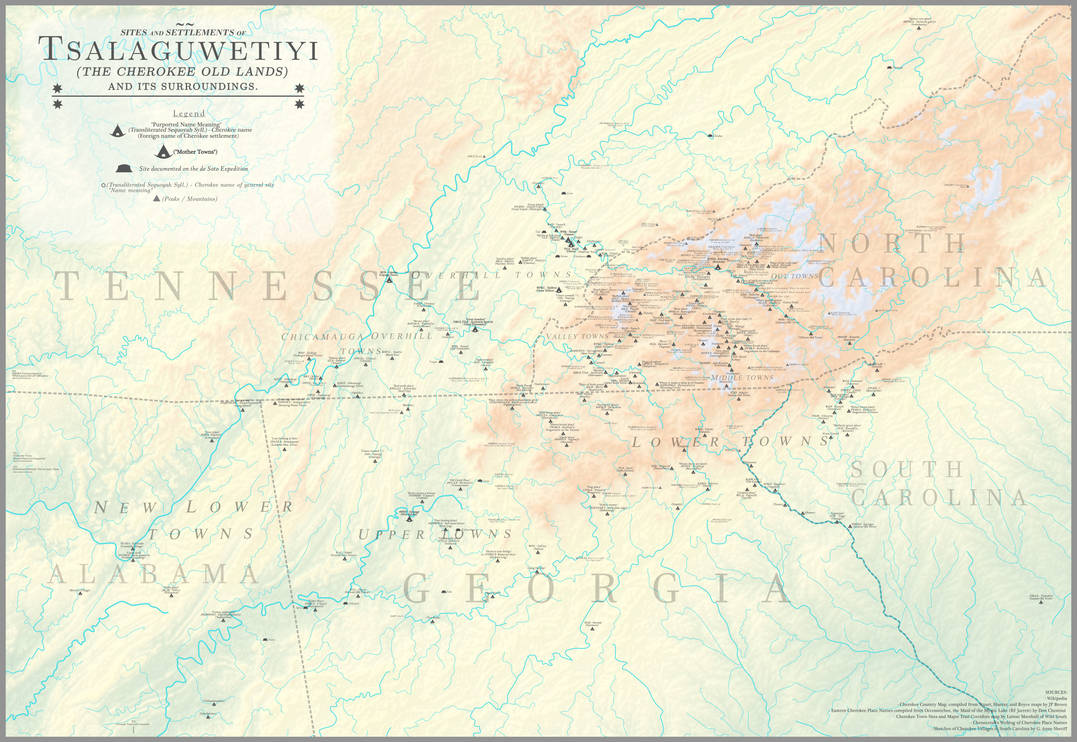
The Old Cherokee Country [OTL] by MarsandCadmium on DeviantArt
www.deviantart.com
I really like how you've put cities in spots that are city-less (or small cities) OTL, but make as much sense as anywhere.Here's a rough and quick look at Louisiana in the FNM-verse:
Also, I enjoy how New Switzerland is very flat (it does have the Sangre de Cristo, which are pretty impressive, but it's still mostly prairie). Still, I guess it does have the highest mountains of anywhere in Lousiana.
King? Bourgeois scum, 20 years in Butugychag!i accept the earth king's humble offer
The town and the name El Paso del Norte, meaning "pass of the north" and signifying the fact that around there is where the Río Grande makes its way through a mountain pass, dates all the way back to 1659, and dropping the "del Norte" off the end (and then, in this case, translating it to French) is the logical thing to do after the border shifts and it's no longer in the north of its country.
(Also, this isn't targeted against you specifically, but I'm always bewildered by the degree to which people are willing to cry convergence for things like river and drainage basin borders, which exist in the natural word and so could very rationally be reused by people in alternate timelines, because they're good, clear borders and all...)
As an aside, the general POD for the FNM-verse is around the American Revolution.
I really don't see what's notably convergent about those divisions. A chunk of the Texas-Oklahoma border is there ('cause it's a river) and a little bit of the Texas-Louisiana border ('cause it's a river), but all the arbitrary lines across the landscape are noticeably butterflied.some states are a tad convergent, but overall a very nice map. I see you're working with vectors. Pretty. Also, interesting that El Paso exists under the same name. I imagine it would still exist given the border, but maybe not by the same name? Nord Huarez or named after a person or family that funded its settlement might work?
I've been working on this since March of last year, with inspiration from Steel Panthers: Main Battle Tank, and of course just in time for the 30th anniversary of the Gulf War (the Desert Storm phase). Namely, a Fourth Reich rising up in Germany, yes a Fourth Reich, complete with Swastikas and goose-stepping and no, it has nothing to do with the EU, which threatens Europe and the world again for Neo-Nazi reasons; and yes it's not a realistic scenario nor does it need to be (it's just for fun). Description: Here

Here is my submission for the cover contest.. The write-up is a lot shorter than mine usually are but hopefully the detail in the map answers any questions you might have about the world. If not, questions and comments are always appreciated.
Very nice! I like those mini-worldAs for additional details: can you point me to the basemap for that?
Wonderful job!So hopefully this map sheds some light onto the extent of the Cherokee nation. I've always been interested in aboriginal names in any country, so expect maps with the same premise as this one in the future as well.
The nation is 56% Magyar, with the next largest being Romanians at 24%. These are the two “favoured” ethnicities of the Union (Croatians are also viewed fairly positively), whilst the various Slavic minorities are treated as lesser citizens (even if officially equal). The Slavic population is generally much lower however due to various wars/genocides in the 19th Century.
The Magyars might be a majority within the territories of the Crown of St. Stephen without the Ottoman invasion, but you're definitely not getting Magyars over 50% in that big an area without a lot of genocidin' and/or ethnic cleansing, something 19th century Europeans OTL generally didn't do much of when it came to other European Christians. (As enthusiastic as they may have been at it with Muslims or people on other continents).
The United Staits of America

The modern day U.S. in the Forgotten No More-verse, with the map itself being written in what is known in this TL as American Standard English (A.S.E.). The push for reformation and a strict departure from the spelling structure of British English was driven by significantly more hostile relations between the U.S. and Great Britain than OTL. The effects of the ASE can be seen not only in the writing of the map in places like the table of contents, but also in the names of most cities, which by 2021 have adopted official spelling changes to match ASE standards. This is not uniform, however, and some places have held on to their traditional spellings.
The ASE is the predominant spelling standard in most of the states in the present day, though there are exceptions. Though the state of Newfoundland & Labrador did adopt an official spelling change, as shown above, the State Constitution has always protected the Oxford Style (a standardized British English) and most Neufaunlanders (ASE) would spell it Newfoundland. In the state of Eustis, though the majority of the state is proficient in ASE, a large segment of the population on Alexandrea Island are also proficient in and prefer the Oxford Style.
The country is divided into 51 states and four territories. The most populous state is Eest Florida, while the least populous state is Glazeor. The ten largest cities are, in order:
1) Chicago, WA;
2) Neu York Citee, NY;
3) Brucklin, NY;
4) Lawentz, OH;
5) Greater Queens, NY;
6) Tempa, EF;
7) Si'al, JM;
8) Filadelfea, PA
9) Toronto, HU
10) Uneon Citee, D.C.
Some in this TL's US refer to the current federal government as the Third Republic, accounting for the first, under the Articles of Confederation, the second, the First Constitution; and the third, under the governing Second Constitution. After a civil conflict in the 1920s, the leading politicians of the time who emerged from this conflict organized a new Constitutional Convention as a means of righting the ship. Some of its major changes involved the restructuring of the Senate into a largely passive role, delegating a larger share of the legislative functions to the House of Representatives. The House also adopted a mixed-proportional districting scheme, where-in each state would have equal shares of FPTP and corrective seats. Another key change was the separation of the judicial branch into its own quasi-branch, almost entirely beholden to the Supreme Court, but with a degree of autonomy and executive functionality and duties.
The major sports watched by TTL Americans would be taunsbal, akin to what we would call baseball; barolbal, akin to basketball; stix, akin to hockey/ice hockey; and gridiron, akin to rugby and American tackle football.
Here's a rough and quick look at Louisiana in the FNM-verse:
Love them! I like how you changed up the grammar in the FNM-verse. The maps are stunning. What program did you use?
What of Uzbek assholes?I've been working on this since March of last year, with inspiration from Steel Panthers: Main Battle Tank, and of course just in time for the 30th anniversary of the Gulf War (the Desert Storm phase). Namely, a Fourth Reich rising up in Germany, yes a Fourth Reich, complete with Swastikas and goose-stepping and no, it has nothing to do with the EU, which threatens Europe and the world again for Neo-Nazi reasons; and yes it's not a realistic scenario nor does it need to be (it's just for fun). Description: Here
I remember coming into this map game after that name was given, and justifying it after the fact that it was basically making *New Mexico truly their own in terms of identity when the Neomexicanos revolted and joined the Louisianians in a Louisianian-Mexican War (no worse than British colonies using German names for provinces like New Brunswick or American states using Spanish names). As a fun divergence, I put *John Sutter there (surely the guy, familiar with the French language, who founded New Helvetia in OTL, would head to a province already with the name...) as a much happier local kingmaker. I remember I had him found "Sutterville" as a parallel to the OTL American-founded downtown that's modern Albuquerque, and the name actually stuck when "Sutterville"/OTL Newtown Albuquerque and the old colonial Albuquerque merged a la real life.I really like how you've put cities in spots that are city-less (or small cities) OTL, but make as much sense as anywhere.
Also, I enjoy how New Switzerland is very flat (it does have the Sangre de Cristo, which are pretty impressive, but it's still mostly prairie). Still, I guess it does have the highest mountains of anywhere in Lousiana.
@Osk
I was intending to tell you this in the main thread when the game truly wrapped up, but I've always remembered and have been exceptionally fond of FNM. Seeing these new maps, they're simply utterly gorgeous and I'm still pleased to see such alternate history "cliches" like a united Anglo-America, independent Francophone Louisiana and Quebec, and independent Hispanophone California actually get explored and detailed upon as they go through history. That's surprisingly rare for some of these "cliches", and so it was a pleasure to not just see it happen but take part in developing them. It's truly a good timeline. It's also nice seeing a heavy go at a more phonetic English spelling, I've been fiddling with something like that myself.
Nice map,Here's a rough and quick look at Louisiana in the FNM-verse:
A few things don't feel like standard French...
If you are aiming for non standard French, then its fine.
Else here is what I'd change :
Petite-Roche
Baton-Rouge
L'Oiseau
Saint-Augustin
NOUVELLE HELVETIE
CADILLAC
MISSISSIPPI
PS : Le Pas seems a really unlikely capital, either of the other tow seem historicaly more plausible.

Oh dear. Where is North Africa?
A tremendously ASB map from the TL of my NationStates region Pax Britannia (https://www.nationstates.net/region=pax_britannia). Broadly a mega Hungary (who avoided obliteration by the Ottomans thanks to a surviving Byzantinium) who now dominates the Carpathian Basin/Balkans and integrated them into the so-called Jagiellonian Union. Jagiellonia (Hungary) also picked up a few colonies over the years, most prominently Libya, but also a chunk of the Levant, a bit of OTL Gabon, Cabinda, and Walvis Bay in Namibia.
The nation is a unitary state dominated by the Hungarians in Buda, much to the chagrin of the union's lesser minorities. The government is a one-party state led by Palatine Laszlo Bardossy (https://en.wikipedia.org/wiki/László_Bárdossy), with a consitiutional monarchy. The royal dynasty is the house of Zapoyla, but they kept the heritage of the extinct-Jagiellonian Dynasty.
So yeah I guess a Hungary wank.
- Status
- Not open for further replies.
Share: