You forgot the #13View attachment 551582
The World of the Man in the High Gulag.
this might be an asb
In this alternate world, sometimes in 1967, The Soviet and American forces in berlin would fire back at each other sparking ww3. With it being a politically divided time, the Americans fuck up and send their military later than they should have. Thanks to this the soviets steamroll across Germany, soon they would capture Bonn, and capitulate West Germany. Eventually by the time the US arrive the rhine has fallen to the Germans. Meanwhile in Asia, NK and China (Sino-Soviet split never happen) would crush the south Korean military and occupied the south. Italy does what Italy dose and get coup by the communist party and join the warsaw pact. In the US, riots occur across the state with many learning of the US deals in dictatorships in many states. By 1973 Paris falls and Most of France falls under communist hands. Eventually the USSR would invade southern Spain where the rest of the nato alliance surrender. Soon the Russians and Chinese invade Alaska and the US surrender in 1975 after the fall of anchorage. In the treaty of berlin, Most of the European states fall under Soviet control. Spain, the UK, and Denmark remain. The Nordic Nations would unite into one nation in 1978. In 1978 the British revolution by republicans would cause the parliament, royal family and loyalist to flee to Canada and Hijack the government taking full control. The USA meanwhile collapses into many states.
You are using an out of date browser. It may not display this or other websites correctly.
You should upgrade or use an alternative browser.
You should upgrade or use an alternative browser.
Map Thread XIX
- Thread starter water123
- Start date
- Status
- Not open for further replies.
My bad. I forgot to add it.You forgot the #13
My submission for MOTF 216:
Absolutely brilliant.
I have no Idea why I made this, and Don't have any ideas on the details.
Perhaps Mexico has remained loyal to Spain because Spain is the only reason the *USA didn't eat _all_ of Mexico?
Earliest reports of KPV cases in northeast China and the Sino-Korean border. Dark red in the Sino-Korean border indicates possible areas of Ground Zero while red-orange indicates early cases in Manchuria which was initially covered up as "mass rioting of dissidents."
Further reading:
Chapter 52: Emergency State (Part 3 - International Crisis and Political turmoil)
Intermission #9 - Maps
I feel like "zombie virus starts in North Korea" is... not a very good look, maybe? To me it echoes the idea of the "communist horde", yknow? Zombie scenarios can be interesting, though.Earliest reports of KPV cases in northeast China and the Sino-Korean border. Dark red in the Sino-Korean border indicates possible areas of Ground Zero while red-orange indicates early cases in Manchuria which was initially covered up as "mass rioting of dissidents."
It's one of the possible theories in my timeline. It does not start in North Korea per-se but within the Sino-Korean border. However, just as with all zombie apocalypse story, my coauthor @Ukron and I decided to keep the cause a mystery.I feel like "zombie virus starts in North Korea" is... not a very good look, maybe? To me it echoes the idea of the "communist horde", yknow? Zombie scenarios can be interesting, though.
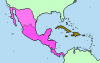
Evolution of Mexico in WorldA:
Mexico, Central America and Spanish Carribean. Right after independence.

Northern Communist Rebellions in Mexico, 1956.

American Occupation in 1957.

Treaty in 1958. Provisional Government of Mesoamerica

Northern Mexican states Break off.

Personal Union with Spain in 1969 and the Maya and Jalisco Autonomies.

 (everything else)
Mexico, Central America and Spanish Carribean. Right after independence.
Northern Communist Rebellions in Mexico, 1956.
American Occupation in 1957.
Treaty in 1958. Provisional Government of Mesoamerica
Northern Mexican states Break off.
Personal Union with Spain in 1969 and the Maya and Jalisco Autonomies.
Attachments

otl map
This map is a general map of the country of Northern Ireland, intended to be as politically neutral as possible. This map will show traditional counties, major roads, motorways, urban areas, physical features, and towns.
With this map, I aimed to fine-tune the style of physical cartography I have been developing. This can be seen in my maps of 1789 France, Scotland, and Ireland, and to a lesser extent, my maps of England and Wales (both modern and futuristic), and Domesday England. I aimed to improve readability, typography, visual balance, and colours.
Rivers and lakes from…
EU-Hydro Public Beta, © European Union, Copernicus Land Monitoring Service 2019, European Environment Agency (EEA), available from land.copernicus.eu/imagery-in-… [Accessed December 2019]
Major rivers are tapered using width profiles, while minor rivers are uniform.
Urban areas from…
Northern Ireland Statistics and Research Agency, 2017. Urban - Rural Classification. [Online], available from www.nisra.gov.uk/support/geogr…. [Accessed May 2020]
A locality’s urban area is shown only if the locality’s population exceeds 50,000.
Digital elevation model from…
EU-DEM v1.1, © European Union, Copernicus Land Monitoring Service 2019, European Environment Agency (EEA), available from land.copernicus.eu/imagery-in-… [Accessed December 2019]
Bathymetric data from…
The GEBCO Grid, GEBCO Compilation Group (2019) GEBCO 2019 Grid (doi:10.5285/836f016a-33be-6ddc-e053-6c86abc0788e), available from www.gebco.net/. [Accessed March 2020]
Northern Irish localities’ populations from…
Northern Ireland Statistics and Research Agency, 2011. Census 2011 Key Statistics: Usual Resident Population. [Online], available from www.ninis2.nisra.gov.uk/public…. [Accessed April 2020]
Irish localities’ populations from…
Central Statistics Office, 2016. E2016: Population and Actual and Percentage Change 2011 to 2016 by Alphabetical List of Towns, Census Year and Statistic. [Online], available from statbank.cso.ie/px/pxeirestat/…. [Accessed May 2020]
Scottish localities’ populations from…
National Records of Scotland, 2016. Population Estimates for Settlements and Localities in Scotland, Mid-2016. [Online], available from www.nrscotland.gov.uk/statisti…. [Accessed April 2020]
Manx localities’ populations from…
Isle of Man Government, 2017. 2016 Isle of Man Census Report. [Online], available from www.gov.im/media/1355784/2016-…. [Accessed April 2020]
Motorways and principal roads from…
DIVA-GIS: Lizard Tech, Inc., the University of California, 1995-1998, available from www.diva-gis.org/gdata [Accessed April 2020]
Ordnance Survey Ireland, 2019, Roads , available from data-osi.opendata.arcgis.com/d…. [Accessed April 2020]
Generally, I have attempted to label all localities with a population greater than 1,000. However, where labels overlap, I have liberally excluded localities with a lower population to prevent labels being so close to each other that the readability of more important localities’ labels is hindered.
Shaded relief created in Blender, merged with hypsometric tint in Photoshop, and cut out in Illustrator.
Where a boundary line overlaps with river or lake, it is offset by 5mm to improve readability.
All summit heights are rounded to the nearest multiple of 5.
Colours…
I designed the colour ramp to be natural to reflect the colours of the Northern Irish landscape, and bright enough that text can be read atop it.
Fonts…
· Serif (used on everything except city names): Georgia Pro
· Sans-serif (used exclusively on city names): Lato
Your'e right of course about Ravensberg, I must admit I thought it came to them much later.@Bob Hope you will want to add Ravensburg to Jülich-Berg in this map. And possibly the last one. I am also unsure if the borders colored for Denmark, Schleswig, and Holstein would be as clear here as I read that they were pretty cut up and spread about because the locals wanted them to be so entangled they couldn’t be separated for economic reasons. Perhaps adding a color for Imperial Cities would be a good idea? Something that stands out more than the standard yellow gold of the church lands of course. Bit hard to make out the borders within those. In your key you Have Cologne labeled as a Bishopric. They were an Archbishoprice for nearly five hundred years at the point in this map, though I assume you put it there mostly to differentiate from the city of Cologne. Going to add a border between Upper, Lower, and Near Austria?
As to Denmark, I'm basing them on a simplified version of @Milites Danish maps - .
I thought about adding in the Imperial Cities but decided to only put in what was relevant to the History I was covering.
The indistinct borders within the Empire are deliberate, I have tried to highlight only the states that are/were/would become important.
Cologne - Damn, your'e right again....... you've no idea how hard it is to admit I was wro....wr....wron... not correct!
Upper, Lower, and Near Austria - these will appear when Ferdinand I splits his lands.

Map of the eastern border of Germany following the Second Franco-German War of 1889-1890
Here are maps of the United States inspired by the "Revolution" series, a series inspired by a post-apocalyptic world where electricity has disappeared, and where the United States plunges into chaos and is thus divided into several states independent ....
Here in New Mexico we prefer to call it "The Land of Enchantment."

It had been two days that the police and frontier guards have closed the border with North Korea.
Could be a sequel to World War Z: those theorized 20 million or so underground North Korean zombies break loose.
My timeline uses a references from World War Z but is independent from it. It more follows a Highschool of the Dead type of outbreak.Could be a sequel to World War Z: those theorized 20 million or so underground North Korean zombies break loose.
you destroyed me mate, good map!snip
thanks! yours is pretty great too!you destroyed me mate, good map!
Based on my Huey long survives and become president timeline (Every man is a king)
Thanks to Huey's long extreme isolationism, The United States never sanctions Japan of its Oil, The US never enter the war. Britain was invaded twice first in 1941, Which failed in 1942. The second one was successful thanks to a german blockaded. In Russia a stalemate occurs between the USSR and Germany, the Germans were close to Moscow but were pushed back to berlin which the Germans next push back. By 1947 the war in the east ended with the Treaty of Washington. It is now in 1955. The world has been divided by the 3 dictators. With all sides having nuclear weapons, the world may face the war to surely end all wars.
An update to my Eastern Civilization TL... 500 years after the first map. Indonesia and the Huns are the major world empires, the former as a massive maritime empire and the latter being reminiscent of the Mongols OTL. I have a full writeup on my devoted thread for this TL here. I've been having fun with all the research for this one, but I'm realizing that because my POD was so far back, the butterflies here are going to be crazy by the time it's all said and done. I just realized that I forgot to include my updated Africa.... and I'm too tired to do it right now, so I'll do it another time.

The Germans build a fleet big enough to sweep aside the Royal Navy? How?blockaded
Uh, maybe the Nazis got to the moon and manipulated the moon's weight to cause tidal waves to hit the coast of Britain before attacking?The Germans build a fleet big enough to sweep aside the Royal Navy? How?
- Status
- Not open for further replies.
Share: