Ryukyu is doing pretty badly. Why, it should have just conquered everything!I'm not certain if anybody else has ever done a Kingdom of Ryukyu Wank before, so I decided to do one I'm probably wrong about that though.
You are using an out of date browser. It may not display this or other websites correctly.
You should upgrade or use an alternative browser.
You should upgrade or use an alternative browser.
Map Thread XVIII
- Thread starter FesteringSpore
- Start date
-
- Tags
- map thread maps
- Status
- Not open for further replies.
*Obligatory disclaimer that I thought of this before Florence was even supposed to hit land*
I decided it sounded fun to put together an election to put a particularly nasty person in power, to watch the world burn
Looking at the aftermath of Hurricane Eric, even the talking heads seemed at a loss for words-- except for some such as "shocking", "devastating", and "How? Cuba is the most prepared state in the nation!" Striking the southeastern coast of Cuba, the devastating storm led directly to a governor described by many as the most vile man in America, and by others as the start of something great.
By the end of it, Democratic candidate Evan Lagerfeld took the stage at his election night party to claim victory and reiterate his promises to take migration matters into the hands of "any level of government with a backbone", rebuild the East, and keep aid in the "right hands". More worryingly, Lagerfeld For President shirts are already for sale online... Cuba is headed in a whole new direction of leadership in the governor's mansion- but the rest of the political spectrum still holds out hope that the state legislature is out of the Democrats' hands at least until next year's legislative elections. Seen below is a county level map of Cuba's 2018 gubernatorial election.

I decided it sounded fun to put together an election to put a particularly nasty person in power, to watch the world burn
Looking at the aftermath of Hurricane Eric, even the talking heads seemed at a loss for words-- except for some such as "shocking", "devastating", and "How? Cuba is the most prepared state in the nation!" Striking the southeastern coast of Cuba, the devastating storm led directly to a governor described by many as the most vile man in America, and by others as the start of something great.
Instant-Runoff voting system for governor, voters rank choices and votes are tallied. Many other states use a two-round FPTP with a runoff- think French presidential elections.
4 Parties:
Republicans, Blue: Fiscally conservative, socially tolerant, party of the suburbs and yuppies.
Liberals, Red: Economically liberal, Socially liberal, party of bleeding hearts, intellectuals, and the secular part of the left.
Democrats, Orange: Economically conservative to populist, socially conservative, the Dixiecrat wing reigned supreme and made a home for the religious/nativist right
Progressives, Green: Economically left-wing and populist, socially conservative. Party of organized labor, AME churches, and rural anti-corporate populism
Governors and legislators serve 4 year terms, set one year off from one another. This election takes populace in march 2018, while the legislature will be up for election in 2019.
When Hurricane Eric slammed into the Southeastern coast of Cuba, bringing category 5 winds and storm surge that washed away full city blocks of Guantanamo and left some small towns as little more than locations on a map, portions of the US state of Cuba were left battered and destroyed. Aid flowed in from across the nation but struggled to reach those who did not evacuate as bridges has been swept away, power lines strewn out like toothpicks, and the Naval Base at the mouth of the bay needed quick repairs to fully unload ships of food, water, and shelter. Tent cities sprang up as the Federal Disaster Agency (The FDA) distributed desperately needed water and food to those who had not evacuated and were left cut off. Hundreds of thousands sat in shelters around the Havana metro area and on the mainland, wondering when they would get to go back to their homes if they even existed.
In this, a surprising number of people began arriving on the devastated coast. Before hitting Cuba head on, Erik delivered a blow across Haiti's southern peninsula and wreaked similar havoc but without the assistance of an economic superpower throwing it's weight behind relief efforts. The ensuing refugee crisis strained the rest of the impoverished nation and the neighboring Dominican Republic, and with hope rapidly fading at home, many struck out across the Cuban Straight for greener pastures in the US. Now, the United States IOTL has almost as much of a "complicated" relationship with immigrants as OTL, but the circumstances are a little rougher now. The coast guard turns back what boats they do catch, but with many boats taken up carrying building supplies to repair the base and trailers to house the homeless, they aren't patrolling as closely as normal. Leaders at the national and state level agree that they couldn't just let these people starve and sleep exposed to the elements, but on the ground locals seethe when they learn that newcomers are receiving aid that they believe should be theirs and in shelters across the state people grumble that they're waiting in line for food and cots when the powerful "ignore them for outsiders" .
In this environment, the 2017 election primaries kick off.
Evan Lagerfeld, a relatively unknown city council member from the coastal town of Baracoa, campaigns in the trailer camps and whips the residents into a politically expedient rage, organizing volunteers left with no job left to go to and telling people that their spite towards the Haitian refugees is not only valid but morally superior. Fliers circulate around regions without power, as the nation watches in horror while the most vulnerable are radicalized and his message takes hold among storm refugees outside of the directly affected area. By the time of the primaries, Lagerfeld wins the Democratic nomination in a wave of nativism and rage. Still, Cuba is a battleground between the Liberals and Republicans in statewide elections, Democrats tend to do little more than win rural interior areas.
2018 isn't a normal year though, numerous Cubans are still left rebuilding and so far the state and national government have treated the race-baited rage as a minor force worth ignoring until it passes as things improve. They don't realize the extent of their failure to address this growing cultural sentiment until it is too late. Maybe this would have worked, had the elections taken place more than 6 months after the storm and people weren't still living in trailers struggling to get insurance to cover their home rebuilding. All the while, Evan hones his message and points out every slow moving infrastructure repair to claim that all money dedicated to not deporting migrants should be used on that instead, that getting rid of the "interlopers" would speed up rebuilding, and generally blaming everything on the current government and the ever-hated outsider.
WhiteDragon25
Banned
I have yet another recent map I made, this time based on the Magitek alt-history world of the anime/manga "Youjo Senki/Saga of Tanya the Evil":

I tried to match the European borders as closely as possible to the source material in the anime and manga, though for the rest of the world I had to take creative liberties as the series' scope never went farther than the not!German Empire's borders and combat theaters.
On a related note, I also have a flag I made for a Spacebattler's fanfic based in the Youjo Senki universe - you can check it out here!
England, the Netherlands and Norway are all Germanic nations. Do you consider them to be all the same?
United Kingdom of England-Norway-Netherlands? I'd ship that.
KapiTod
Banned
United Kingdom of England-Norway-Netherlands? I'd ship that.
Well we almost had both those at different tines- Harold Hardrada and William of Orange respectively. This is less a ridiculous grouping of states together and more an example of a semi-plausible union.
United Kingdom of England-Norway-Netherlands? I'd ship that.
Well we almost had both those at different tines- Harold Hardrada and William of Orange respectively. This is less a ridiculous grouping of states together and more an example of a semi-plausible union.
Challenge accepted

Skallagrim
Banned
Here are some "_______ to a Virgin Earth" posts I made for fun.
I like the enthousiasm, but ultimately, these are "just" maps of the relevant regions, placed on an empty planet... with nothing else shown. The point of an ISOT is to show what happens next. How do these countries thrive, fail, change, develop etc. in this new and empty world? If you don't try to show that, it's a bit of a shallow scenario, isn't it? You did it right with your "vanished Russia" scenario-- more like that, please!
")
To give an example of what I mean, this is a take on your "Central Powers in 1914" ISOT:
As you can see, I imagine things changing. This is my take on the world, 50 years later. Things have moved on in that time. I imagine that with no external powers around, the Catholic southern states of germany will be less inclined to be bossed around by Prussia. I have them gravitating into a Habsburg-led union instead. Meanwhile, the Habsburgs lose control of their more eastern territories. They might be able to hold them by force, but moving into a lot of empty territory to the west (just there for the taking) is more attractive. As such, Italians from Trentino start building their own kingdom, Croats and Serbs spin off into independence, and the Hungarians go off on their own. The Romanian attempt at creating a country for themselves is rather hampered due to being in between Hungary and Bulgaria, but though small, they are at least free.
The Ottomans lose control over their Arabic hinterland in the confusion of the "event", but soon see a chance to expand their Turkic empire in various directions. The Arabs set up two competing caliphates (one shia, one sunni) and the Armenians and Kurds found independent kingdoms on the eastern fringes of the Ottoman domains.
In Africa, the Ottomans dominate the northern shores and some intrepid Arabs are settling the Horn, but the greater share is claimed by the Prussian Empire. Their colonies shrunk back to coastal settlements soon after the "event", but with Berlin commanding the most powerful fleet remaining on earth, contact was soon re-established. The acttal colonies slowly began expanding again, and Prussia claims vast swaths of Africa.
In America, both Prussia and the South German Empire have quickly set up colonies at strategic locations, mostly with an eye to the future-- none of these settlements is really thriving yet.
Over in the far east, Germany's colony in New Guinea failed spectacularly before any German ships reached it. It took even longer to re-establish contact with the German holdings in China. As it turns out, these had been doing very well on their own. The entire economic exclusive zone got ISOTed, so there were a lot of Chinese and relatively few Germans-- but the Germans had the ilitary-grade weapons. What has emerged is a bit like a Raj, with a German aristocracy presiding over a Chinese country. Some intermarriage was required almost at once to avoid revolts, and once Prussian ships re-established contact a decade later, the former colony was no longer interested in re-joining Imperial Prussia.
(I'd really like to see how you picture this scenario, or any of the others you posted, changing over the years and decades, @TheDetailer.)
I like the enthousiasm, but ultimately, these are "just" maps of the relevant regions, placed on an empty planet... with nothing else shown. The point of an ISOT is to show what happens next. How do these countries thrive, fail, change, develop etc. in this new and empty world? If you don't try to show that, it's a bit of a shallow scenario, isn't it? You did it right with your "vanished Russia" scenario-- more like that, please!
To give an example of what I mean, this is a take on your "Central Powers in 1914" ISOT:
View attachment 408384
(I'd really like to see how you picture this scenario, or any of the others you posted, changing over the years and decades, @TheDetailer.)
I actually am making a series of maps on my take on the Central Powers ISOT, which I hope will release today.
I have some different views on what will happen, such as both the Austrian-Hungarians and Ottomans fracturing before the 30s.
EDIT: Also, I will take your advice on expanding upon what happens afterward, I kinda just published them.
Skallagrim
Banned
I actually am making a series of maps on my take on the Central Powers ISOT, which I hope will release today.
I have some different views on what will happen, such as both the Austrian-Hungarians and Ottomans fracturing before the 30s.
EDIT: Also, I will take your advice on expanding upon what happens afterward, I kinda just published them.
Awesome, I'm looking forward to seeing it! Let the great fracturing of empires commence!
Rememeber to show internal divisions in all their glory. Heck, for agermany you can expand the various monarchies easily. The Bavarian King during WWI wanted Alsace and Antwerp added to his realm. I am sure others had similar desires. Also, you going to include Jabal Shammar, the Dervish State, the Senussi, and Darfur? Though they are more co-belligerents I suppose. Then again, I am sure there are plenty of maps that would include the US in the Entente despite them vocally stating their were not.I actually am making a series of maps on my take on the Central Powers ISOT, which I hope will release today.
I have some different views on what will happen, such as both the Austrian-Hungarians and Ottomans fracturing before the 30s.
EDIT: Also, I will take your advice on expanding upon what happens afterward, I kinda just published them.
What if ww3 ended in a stalemate? I know it's not realistic but whatever.
This one is very unrealistic, it's kind of a world war one switcheroo between France and Germany.
Mate, you've gotta change that text colour. I didn't even realise those were words at first.
Oof. That's unfortunate. Sorry about the difficulty of reading the text, guys. It looked good on my computer, but that might just be my tendency to have high brightness and/or the graphics settings of my computer.This is gorgeous, but perhaps a darker colour for the text, makes it a bit hard to read.
Unfortunately it might be a while before I can put up a more readable version; my graphics program is very "dumb" (it's Paintbrush for Mac) and so to change the text color I'll have to go in and basically write it all again, and also format it by hand. But I will try to have an updated version as soon as I can.
Oof. That's unfortunate. Sorry about the difficulty of reading the text, guys. It looked good on my computer, but that might just be my tendency to have high brightness and/or the graphics settings of my computer.
Unfortunately it might be a while before I can put up a more readable version; my graphics program is very "dumb" (it's Paintbrush for Mac) and so to change the text color I'll have to go in and basically write it all again, and also format it by hand. But I will try to have an updated version as soon as I can.
Wouldn't it be easier to make the background darker?
The issue that presents is it leaves all sorts of unpleasant looking artifacts around the text from the previous background color, and going in to change those by hand is more work than just doing the text over. It comes down again to the limitations of Paintbrush, but more advanced programs tend to be beyond me unfortunately.Wouldn't it be easier to make the background darker?
After I made a map of a continent-spanning New France back in July, I started to work on a *county map for the country in an 8K-BAM format. It took a good two months to finish because it got kind of tedious to work on and I ended up adding to it only intermittently. Considering the recent Francophilia in the map thread, I figured now would be a good time to finish it.

Like its mother country across the Atlantic, New France adopted the département system for carving out more localized administration. In terms of function, they are very similar to counties in the neighboring United States. More populous départements tend to have more powerful local town/city governments, while in more rural areas the département is the primary (and sometimes only) local government. They tend to have boundaries based more off of straight lines and arcs than natural boundaries like rivers, especially in the Grandes Plaines (where many of the départements' lines were drawn with a standardized system of diagonal lines). Départements' population vary wildly from just a couple hundred to millions. Départements have names of all sorts of origins such as place names, important people, and local features; the older areas of New France have département names that are mostly French in origin, while areas settled later have more varying names that tend to reflect the origin of its settlers.
Like its mother country across the Atlantic, New France adopted the département system for carving out more localized administration. In terms of function, they are very similar to counties in the neighboring United States. More populous départements tend to have more powerful local town/city governments, while in more rural areas the département is the primary (and sometimes only) local government. They tend to have boundaries based more off of straight lines and arcs than natural boundaries like rivers, especially in the Grandes Plaines (where many of the départements' lines were drawn with a standardized system of diagonal lines). Départements' population vary wildly from just a couple hundred to millions. Départements have names of all sorts of origins such as place names, important people, and local features; the older areas of New France have département names that are mostly French in origin, while areas settled later have more varying names that tend to reflect the origin of its settlers.
damein fisher
Banned
The State of the Yucatan
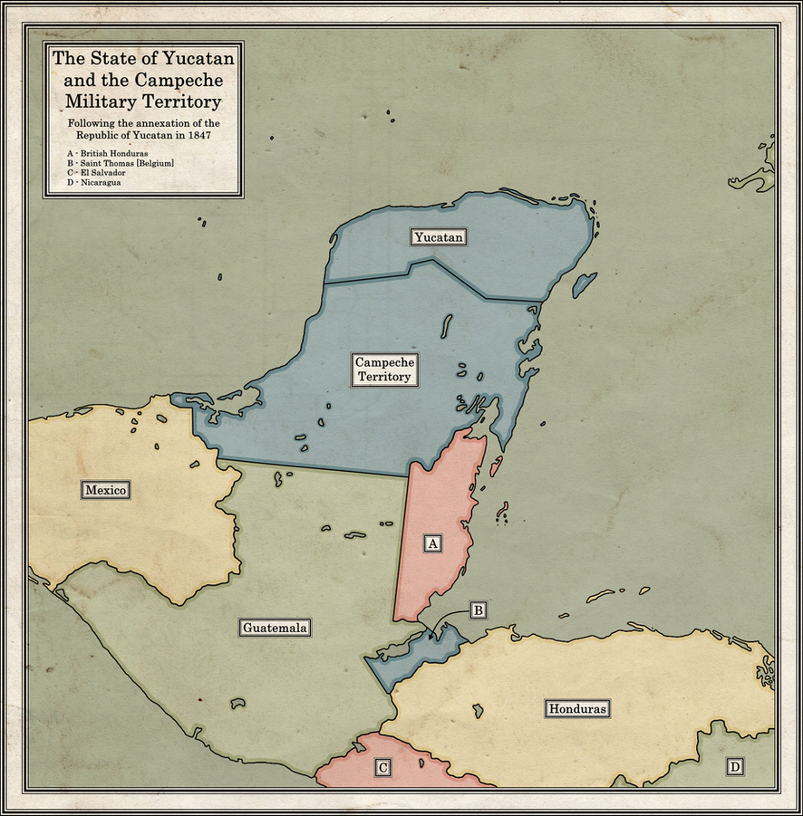
The Republic of Yucatan had been de facto independent since 1841, however in 1847, a large number of native Mayans revolted. Within only a few months, they were able to draw the Yucatan government to the coastal cities. Yucatan sent representatives to Jamaica, Cuba and Baltimore to try and receive foreign aid. However, the British and French interests in Mexico kept them from aiding the republic and the Spanish had long since abandoned claims to the North American mainland.
Fortunately for Yucatan, the United States had already occupied Tabasco in the Mexican-American War and with their history in the Seminole Wars, were confident in their abilities to fight the Maya. After a short debate in congress, the United States of America annexed the Republic of Yucatan. In short, the United States had highly overestimated their military might against Mayans, underestimated their true strength. Not only were the Mayans more organized, numerous, and well armed than any other Native group the United States had fought, but they were fighting in the jungles of the Yucatan peninsula.
Within a few months of their campaign, the United States knew their mistake. The state was divided into the State of Yucatan [Under full US control and only taking up the Northern Coast] and the military territory of Campeche, which was under almost full Mayan control. In the US, the creation of the territory was marked as the end of the Maya-American War. However, conflict in the territory would continue between the US military and Maya Guerrilla rebels until the Mayan Ceasefire in 1862, when the Union recalled the military to fight in the civil war.
This timeline is part of the larger timeline; The Lion, the Eagle, and the Rooster, more can be found here. A larger version of this map can be found here. As usual, any form of feedback would be greatly appreciated!
Philip
Donor
What if ww3 ended in a stalemate? I know it's not realistic but whatever.
That basemap is a crime against humanity.
- Status
- Not open for further replies.
Share: