Map Thread XV

Status
Not open for further replies.
I intended it to be that the Nigerian government managed to keep control of most of its territory, but not all of it, and that they released a small portion of the north as a compromise, rather than having to deal with an annoying ass war in harsh times.

Part of my (admittedly poorly formulated) point was that there was no such animal as a "Nigerian government" in 1905.
 
Were they capable of that sort of conquest? I wasn't aware. I'll keep that in mind should I ever fix the scenario.
I mean, look at the 2nd Boer war. It took around 500,000 British troops to conquer the two states who had a combined force of around 40,000. And that was only after the British put a large segment of the Boer population in concentration camps to drive out the guerrilla forces.
They don't have similar cultures to the Boers, and the Cape Colony was never powerful enough or united enough to take the Natal.
I was saying that the culture of English settlers in the Cape was similar to British settlers in Natal (the region where the British outnumbered Boers), and that the culture of Boers who remained in the Cape was similar to those who moved into the Boer states. Obviously the British and Boer cultures differ greatly, not to mention the native cultures as well.
 

Jcw3

Banned
I mean, look at the 2nd Boer war. It took around 500,000 British troops to conquer the two states who had a combined force of around 40,000. And that was only after the British put a large segment of the Boer population in concentration camps to drive out the guerrilla forces.

I was saying that the culture of English settlers in the Cape was similar to British settlers in Natal (the region where the British outnumbered Boers), and that the culture of Boers who remained in the Cape was similar to those who moved into the Boer states. Obviously the British and Boer cultures differ greatly, not to mention the native cultures as well.

I understand. I usually say that I'll take this into account for future updates, but I'm likely retiring from mapmaking after this one, so I guess all I can say is that I know that now.
 

Jcw3

Banned
Like map ideas? I'm sure you could get some suggestions if you run out of ideas.

I've had this signature for over a year now and have received no takers.

(This isn't the place for this conversation anyway. If you'd like to continue it, I have my own maps thread. Should still be on the front page of Maps and Graphics.
 
The Two Americas

Beautiful map!

Comment on boundaries.

National: The fact that The CSA got Indian territory, but not the Neutral strip is interesting, but Virginia is sort of odd to me. I'm surprised it was able to keep all of OTL West Virginia while losing the portion of Virginia on the Eastern Shore to Maryland.

State: Sort of surprised at the split the difference between Utah and Wyoming, but other than that doesn't look too bad, some of the states might change even more with an 1860's POD but not bad.

Surprised that all of the Contiguous US and all of Southern Canada have state/provincehood. This includes Oklahoma (which doesn't surprise me much), Arizona and New Mexico and Alberta and Assinobia.

In fact the name Alberta is IMO, the oddest thing here. The name of the Province of Alberta comes from the District of Alberta created in 1882 after Princess Louisa Caroline Alberta fourth daughter of Queen Victoria. While she was born before the expected POD 1848, the likelihood of her marrying (1871) a man who was then appointed Governor General of Canada in 1878. You can use Athabasca, I guess.

Some of the roads look a little odd. Going from Cleveland to Pittsburgh seems to have two choices, both odd, I'm surprised the road doesn't go all the way to Seattle. And am a little surprised that no Salt Lake to Arizona or Southern California. connection.
 
I thought that the Reichsbund included the Netherlands, Belgium and Northern France? Wasn't it such in some previous maps?
The reichsbund only includes the six nations shown there. What you're talking about is the German Possession Area :)
You could compare it like the USSR(Reichsbund), its puppet states such as the GDR (German Possessions) and the Warsaw Pact(Nordic Alliance)


It's complicated, and I really should finish VBAM so everyone gets the entire timeline... >.<
 
Well on the upside, they'll be putting the red in redneck very soon...
hith-blair-after-the-battle-2.jpg

I love how everyone has started using my little pun about that :D
 
Warning
Beautiful map!

Comment on boundaries.

National: The fact that The CSA got Indian territory, but not the Neutral strip is interesting, but Virginia is sort of odd to me. I'm surprised it was able to keep all of OTL West Virginia while losing the portion of Virginia on the Eastern Shore to Maryland.

State: Sort of surprised at the split the difference between Utah and Wyoming, but other than that doesn't look too bad, some of the states might change even more with an 1860's POD but not bad.

Surprised that all of the Contiguous US and all of Southern Canada have state/provincehood. This includes Oklahoma (which doesn't surprise me much), Arizona and New Mexico and Alberta and Assinobia.

In fact the name Alberta is IMO, the oddest thing here. The name of the Province of Alberta comes from the District of Alberta created in 1882 after Princess Louisa Caroline Alberta fourth daughter of Queen Victoria. While she was born before the expected POD 1848, the likelihood of her marrying (1871) a man who was then appointed Governor General of Canada in 1878. You can use Athabasca, I guess.

Some of the roads look a little odd. Going from Cleveland to Pittsburgh seems to have two choices, both odd, I'm surprised the road doesn't go all the way to Seattle. And am a little surprised that no Salt Lake to Arizona or Southern California. connection.
They're railroads are labeled as that on the map ffs and the ones you commented on are from OTL. Take it up with Cornelius Vanderbilt. Also to be honest I'm going to change literally nothing and listen to none of it out of spite because since I posted it I've had people trying to nitpick it to death and after a while

idgas.gif

I love how everyone has started using my little pun about that :D
No, I got it from the real life Communist group Redneck Revolt.
 
Nice stuff there. Although for some reason I suspect Yuwu was actually an avatar of Nyarlathotep. :p

Also, a suggested edit:

I mean, Yuwu's civilization is a type V civilization on the Kardashev scale, though I went with a "hard light limit" sort of thing that made interstellar travel impractical, thus the reason why they would develop inter-dimensional travel and dyson spheres as opposed to bothering to go to places like Alpha Centauri. Thus, from our perspective, they probably do seem pretty Lovecraftian :p

And touche, good idea.
 
Very cool. I have questions.
Thanks, I'll try to answer.
1) Where's Neunassau?
Decided against it.Thought it would be more interesting to have an Anglo-Quebec within Mexico instead.
2) Please tell the story behind the Watauga Republic!
The first American government Pitt had created proved incapable of governing the colonies properly. The colonies that were members of it refused to pay taxes which stifled Congress's ability to govern and more importantly, pay the army that was fighting a large Native American confederation in the west (a result of a prolonged Dunmore's war with backing from the Spanish). When the war with the confederacy was finally dying down, the colonies wanted to disband the army to avoid paying them. As many of the soldiers were deeply in debt and would surely be thrown in prison if they returned home, decided to revolt under the command of Benedict Arnold and force congress to pay them. The rebellion was eventually quelled by loyalist forces and British intervention but it did lead to a constitutional convention which gave America a more centralised government. Many of the defeated soldiers chose to flee towards the back country where they created several new republics, the most successful being Watauga.
3) What's the Piratani Republic?
It was a puppet state of Platinea before being annexed but I forgot to erase it from the map.
4) Also, how the heck did the 'Egyptian Empire' get so big?
Egypt gained independence from the Ottomans earlier ITTL and a figure like Muhammad Ali Pasha emerged and lead Egypt far more successfully than Ali did.
 
Louis XV died of a heart attack in 1770, Choiseul backed Spain during the Falkland Crisis and went to war against Britain that ended inconclusively after three long years.

Interesting - I like the colour scheme for what seems like a fairly gloomy, conservative world.

WIP update!!

Hmm. Uber-Mussolini? The Regno di Zeta is throwing me off.

---

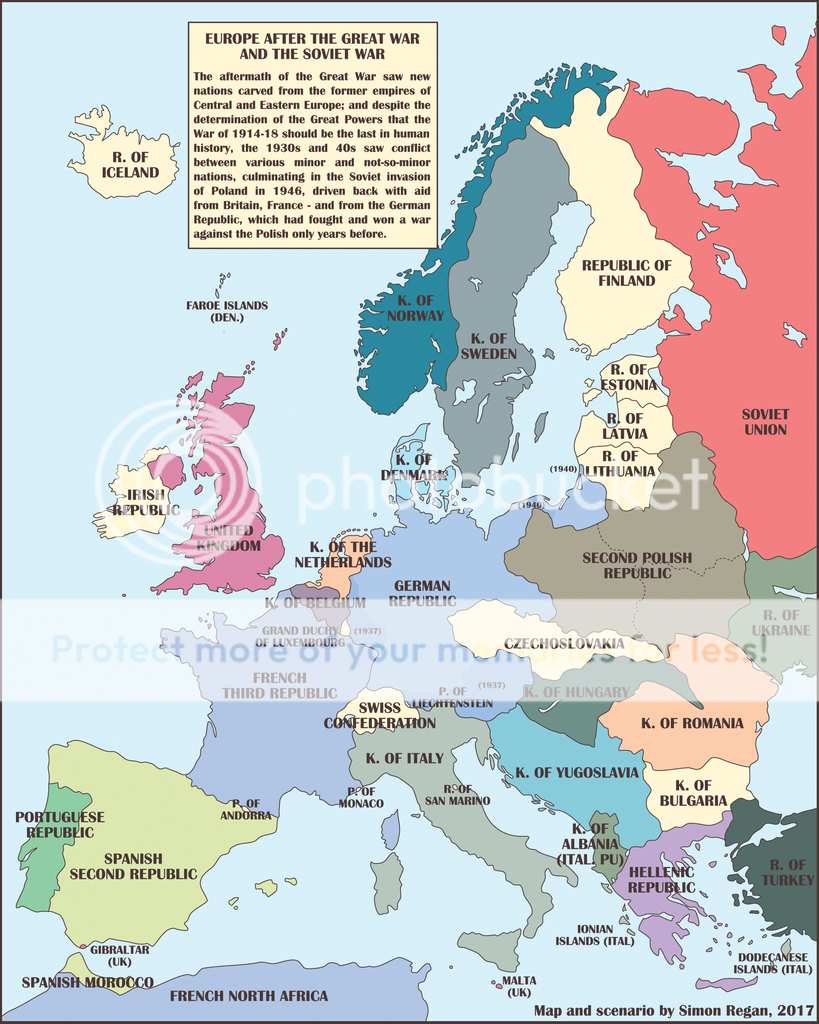
Just to get me back into practice, a pretty simple map of Europe in the world of Weimar Forever, which takes as its POD the election of DVP candidate Karl Jarres in the 1925 German Presidential Elections (IOTL he won the first round then stood aside in favour of Paul von Hindenberg). Credits got to SteveW, whose TL 'Jarres Goes For It' furnished a lot of historical background.

In the comments for my first map, I mentioned how I envisaged a limited war in Eastern Europe, leaving Poland with 1921-ish borders but large and restive Belarusian and Ukrainian populations who are pacified with more autonomy, but possibly break free later; this map depicts how I see that looking, together with a small East Ukrainian state largely dependant on Poland.

Hungary fought a regional war against a *Little Entente (minus Czechoslovakia) and won, reclaiming some of its Dual Monarchy territory, though not enough to satisfy the Greater Hungary advocates. Mussolini took advantage of the confusion to grab the Dalmatian islands and similarly seized the Ionian islands during the Greek civil war.

Spain, meanwhile, managed to avoid civil war, with Franco arrested in the Canary islands in 1936; albeit the republican/leftist consensus is fragile.

Britain and France are struggling with an uptick in civil unrest in their colonies for which they (not entirely accurately) blame the Soviets.

As described in the other map this is about as much territory as I see Germany as being able to take without another war with the Entente, and this requires a number of things to go Jarres' way - a German Sudeten Republic is declared in Czechoslovakia but collapses from lack of support from the population before Germany feels emboldened enough to send in troops; which means no Sudeten Crisis. Poland (after provocations from Germany) invades and occupies the Free City of Danzig, meaning Jarres can present his country as acting in self-defence by seizing it and a corridor to East Prussia.

Memelland is similarly seized after Lithuania's government is overthrown by Luxemburgist revolutionaries; Germany sends in troops to arrest the coup leaders and 'restore order', with support from Britain and France, but it becomes clear they intend to keep the Memelland.


Weimar%20Europe_2.png~original
 
Last edited:
Top
Status
Not open for further replies.
Top