You are using an out of date browser. It may not display this or other websites correctly.
You should upgrade or use an alternative browser.
You should upgrade or use an alternative browser.
Medieval America Tk II: Discussion Thread
- Thread starter jmberry
- Start date
How will the Great American Desert be taken into account?
If you mean the Great Plains, that was the one part of the original website that was fully devloped. Cowboy culture, horse archers, and New Israelite religion.
Far Southern and Baja California
As I put together the map and plan for the Free Zone, I keep going back and forth on the question of its borders and its neighbors. I had originally assumed that San Diego and Tijuana were a part of the FZ. As I worked with a physical map I came to see them more as a loosely affiliated vassal; and now, reading White's original description, I am starting to wonder if they should be attached to the FZ at all.
Either way, San Diego and Tijuana are certainly not great cities. A small successful irrigated-farming kingdom could establish itself there, but it would not be any kind of rival to the Free Zone. In between is the even-smaller basin around Escondido, which could be a vassal of the FZ or of San Diego.
Mexicali and the Colorado Delta make up what is potentially a very significant region. White seems to have ignored it because it lies only partly inside the US, but it is an important part of the overall picture in the southwest. We need to remember that those lines on the map are arbitrary and do not exist in this world. The Delta would probably be a hydraulic empire in its own right. Since these all seem to have their own ludicrous religions (maybe this is necessary when you have a god-emperor in charge of things), this one might be a breakaway form of Catholicism, embodying the unique traits of Mexican Catholicism, but distorted to an extreme degree.
The land around Ensenada a bit down the peninsula probably won't be much more than a chiefdom and occasional vassal of the Free Zone or the Delta. Beyond that, it's probable that the Baja peninsula is a desert full of small wandering clans, until you get to the southernmost tip, which may be either an independent maritime state, or part of an empire on the mainland.
Here is a reference map showing the likely settled parts of the region. Feedback and thoughts?
Last edited:
I didn't think of one or more of the Nuncios, being ambassadors more than anything, acting as de facto popes, but that would be a good solution, I think. I especially like the potential religious hotpoints in the Caribbean, which would keep things fluid between the various broad civilizations' regions. Beyond that I agree largely with your divisions, with one caveat that I'd like to discuss below.The official term, as far as I understand it, is Papal Nuncio.
How I see it is this:
-Quebec and (core) Mexico are loyal(ish) to the Nuncio and thus to Rome - this is what appears on the religion map of the original website, and should probably be kept. After that, though?
-The Caribbean and Central America are a mishmash due to competing influences from Mexico, the US, and Louisiana and the varied ethnicities of the inhabitants.
-The north coast of South America is likely the same way
-The Andes are Catholic, in the same way as those Armenian guys are
-Coastal Brazil is likely divided between Catholicism and Sairo ... Sairea ... Brazilian Voodoo
-Of all Latin America, the Platinean region is the most likely to go full fledged schism with Rome, and that church is likely expanding into Brazil as well
-The Amazon inhabitants have likely reverted to Animism
On the subject of Mexicali, and more broadly along the northern border of what we would call Mexico, I tend to agree that more esoteric/syncretic brands of Catholicism are going to be dominant as a result of the various hydraulic empires and smaller desert groups trying to maintain their own independence and the loyalty of their own citizens. The northern states in Mexico are already historically reluctant to always side with the core of Mexico, and a combination of closer ties with US Hispanics on the other side of the border and that political independence could strengthen diverse creeds to oppose Mexico in general. If we're being really stereotypical and ignoring a lot of effects of the collapse, the border regions are stronger regions of cartel control and have little to do with official Mexican authority, which could be a factor if you want to include that.Far Southern and Baja California
As I put together the map and plan for the Free Zone, I keep going back and forth on the question of its borders and its neighbors. I had originally assumed that San Diego and Tijuana were a part of the FZ. As I worked with a physical map I came to see them more as a loosely affiliated vassal; and now, reading White's original description, I am starting to wonder if they should be attached to the FZ at all.
Either way, San Diego and Tijuana are certainly not great cities. A small successful irrigated-farming kingdom could establish itself there, but it would not be any kind of rival to the Free Zone. In between is the even-smaller basin around Escondido, which could be a vassal of the FZ or of San Diego.
Mexicali and the Colorado Delta make up what is potentially a very significant region. White seems to have ignored it because it lies only partly inside the US, but it is an important part of the overall picture in the southwest. We need to remember that those lines on the map are arbitrary and do not exist in this world. The Delta would probably be a hydraulic empire in its own right. Since these all seem to have their own ludicrous religions (maybe this is necessary when you have a god-emperor in charge of things), this one might be a breakaway form of Catholicism, embodying the unique traits of Mexican Catholicism, but distorted to an extreme degree.
The land around Ensenada a bit down the peninsula probably won't be much more than a chiefdom and occasional vassal of the Free Zone or the Delta. Beyond that, it's probable that the Baja peninsula is a desert full of small wandering clans, until you get to the southernmost tip, which may be either an independent maritime state, or part of an empire on the mainland.
Here is a reference map showing the likely settled parts of the region. Feedback and thoughts?
It would be a good way to keep Latin American influence more limited in the west, if Mexico is concerned with dealing with their rebellious/*heretical
"northern marches" before moving beyond.
On the subject of Mexicali, and more broadly along the northern border of what we would call Mexico, I tend to agree that more esoteric/syncretic brands of Catholicism are going to be dominant as a result of the various hydraulic empires and smaller desert groups trying to maintain their own independence and the loyalty of their own citizens. The northern states in Mexico are already historically reluctant to always side with the core of Mexico, and a combination of closer ties with US Hispanics on the other side of the border and that political independence could strengthen diverse creeds to oppose Mexico in general.
"Hydraulic Empires" make sense for the lower Colorado, Sinaloa (together with BCS, maybe), the land around Chihuahua city, and Monterrey. The lower Rio Grande/Bravo valley would blend with the rest of the Gulf Coast region. And if they do indeed have distinct religions, Mexico has a lot to offer. Santa Muerte could be the basis for one of them (fitting the pattern elsewhere in the region).
If Bajo Colorado (Mexicali) has its own independent Catholic church, then the heretics who flee up the river to Las Vegas might just be conventional Catholics.

I understand that we're doing the US first before moving on to other countries, but I really feel that the north of Mexico would form a single region together with the western US, just with different languages and religions.
If we're being really stereotypical and ignoring a lot of effects of the collapse, the border regions are stronger regions of cartel control and have little to do with official Mexican authority, which could be a factor if you want to include that.
I don't think there's any reason to invoke the cartels specifically; the north is going to fragment either way.
It would be a good way to keep Latin American influence more limited in the west, if Mexico is concerned with dealing with their rebellious/*heretical "northern marches" before moving beyond.
What do you mean? Latin American influence is fairly substantial in the west, isn't it? I've certainly been assuming that as I've prepared material for the Californias. The southern forms of Californian English have Spanish influence in their vowel sounds and some of their grammar. And the Virgen de Guadalupe is worshipped in both the Free Zone and the Republic (under a different name). Beyond California, Bajo Colorado is going to interact a lot with New Mexico, and the Rio Grande/Bravo links communities on both sides of the former border.
I tend to agree. There's too many connections of geography, not even considering human connections and influence that's bound to spread based on demographics and proximity, that they should be very similar."Hydraulic Empires" make sense for the lower Colorado, Sinaloa (together with BCS, maybe), the land around Chihuahua city, and Monterrey. The lower Rio Grande/Bravo valley would blend with the rest of the Gulf Coast region. And if they do indeed have distinct religions, Mexico has a lot to offer. Santa Muerte could be the basis for one of them (fitting the pattern elsewhere in the region).
Heh. "City of Sin" by reputation, actually a bunch of stubbornly orthodox Catholics? That would definitely make them an interesting player in their own right, caught between Scientologists, Mormons, New Agers, and other heretical sects as they are.If Bajo Colorado (Mexicali) has its own independent Catholic church, then the heretics who flee up the river to Las Vegas might just be conventional Catholics.
I generally agree. Northern Mexico has many areas that fit well with the hydraulic empires, and should be considered as strongly connected to that area, especially considering how much of the Southwest is going to be Mexican-influenced/descended in areas.I understand that we're doing the US first before moving on to other countries, but I really feel that the north of Mexico would form a single region together with the western US, just with different languages and religions.
Good, we're in agreement then. That would be a little too tongue-in-cheek IMHO.I don't think there's any reason to invoke the cartels specifically; the north is going to fragment either way.
Sorry, my bad. I meant influence as in outright political contact or a history of military conflict post-Collapse. Mexico would be one of the few areas that could actually threaten California militarily to some extent, by sea if not by land, and so something must be more important to them than opening that can of worms for so long. I'm just suggesting the northern Mexico+Southwest region would be one of those major concerns, especially if, say, heretical movements are fleeing north and gathering strength to come back and cause havoc every now and then, mixed with interests to the South and Caribbean trade focus.What do you mean? Latin American influence is fairly substantial in the west, isn't it? I've certainly been assuming that as I've prepared material for the Californias. The southern forms of Californian English have Spanish influence in their vowel sounds and some of their grammar. And the Virgen de Guadalupe is worshipped in both the Free Zone and the Republic (under a different name). Beyond California, Bajo Colorado is going to interact a lot with New Mexico, and the Rio Grande/Bravo links communities on both sides of the former border.
Linguistically, there should be extensive influence, if not outright descent from Spanish in certain areas. Culturally, I agree that the Virgin could be absorbed not just in California, but in the New Age Hydraulic Empires especially. In fact, a lot of the trappings of Mexican folk Christianity might be a good template for how Scientology and New Age religions adapt to fulfill the average peasant's spiritual needs.
Well, here's an idea, anyway. I know we are trying to stay within US/Canada before moving on; so I tried to show only those areas that directly impact North America.
I still ought to write my Free Zone description, but I was having a lot of fun with this.

I still ought to write my Free Zone description, but I was having a lot of fun with this.
Last edited:
So, just to be clear on your map key, the gold is hydrualic empires, the green are horse nomads and the red is Mexico's primary state with the yellow as Lousiana and related gulf states?Well, here's an idea, anyway. I know we are trying to stay within US/Canada before moving on; so I tried to show only those areas that directly impact North America.
I still ought to write my Free Zone description, but I was having a lot of fun with this.
If that's right, Monterrey could act as a strange middle point between New Isrealite culture and Mexican borderlands. That definitely could have influence on the Gulf coast of Texas.
On that note, IIRC, in the original version the gulf coast of Texas retained some separate identity from the plains-centered New Isrealite cultures that dominate most of the state. If that still seems reasonable, I would guess that the Gulf Coast would be equally full of city states in tributary relationships to defend against predations of the nomads and hostile territories. Mexican and Texan enclaves on the coast would be odd outposts of Non-denominational or Catholic Christianity in the face of New Isrealite raids and Voudou-based conquests. In this case, Galveston and Corpus Christi are vital Gulf-trading cities, while San Antonio, Dallas, and Austin have long since fallen to New Isrealite influence. OTOH, Austin and San Antonio are more in hilly slightly more agriculturally sound areas, and could act as fringe cities for both New Isrealite civilization and whatever civilization dominates the gulf coast.
Of course, I know much less about Texas than the Great Lakes, so this is all speculation. Feel free to correct me if I'm wrong.
Cowboys and Trade
Counter to the popular misconception held by both the Hydraulic Empires and The Eastern Feudal States the Nomadic New Israelite people of the Great Plains are not in fact simple barbaric raiders. In fact the Cowboy Tribes have a distinct and complicated material culture. While the great wealth of the Cowboy peoples has always been in their livestock a common secondary source of wealth and prestige has developed over the past several hundred years: trade.
It is a well known fact that even the most fearless Deserati missionary or Wisconsinite trader cannot cross the plains, the distances are too far and the natives too fearsome. So how is it that fine Californian Wine turns up regularly at feasts in Quebecoise courts? Well it is because the Cowboys of the Great Plains are an industrious and intelligent people.

The major trading pattern on the northern plains begins along the Yellowstone River where Horses, Cows and other goods are traded to the Deserati merchants for wine, silk, hemp/marijuana, dried chilies and other goods that are rare in the east. The trade route then follows the path of pilgrims to Rushmore where goods are exchanged with eastern tribes for horses, cattle, eastern goods but also given as gifts or as dowries as during the annual Festival of the Faces marriage is quite common. From there the goods are taken most usually to the Iowans where they are traded for tobacco, whisky, maple syrup and other eastern goods unavailable in the west. For the northern tribes this trade has increasingly replaced raiding as the most common form of interaction with the settled peoples.

Counter to the popular misconception held by both the Hydraulic Empires and The Eastern Feudal States the Nomadic New Israelite people of the Great Plains are not in fact simple barbaric raiders. In fact the Cowboy Tribes have a distinct and complicated material culture. While the great wealth of the Cowboy peoples has always been in their livestock a common secondary source of wealth and prestige has developed over the past several hundred years: trade.
It is a well known fact that even the most fearless Deserati missionary or Wisconsinite trader cannot cross the plains, the distances are too far and the natives too fearsome. So how is it that fine Californian Wine turns up regularly at feasts in Quebecoise courts? Well it is because the Cowboys of the Great Plains are an industrious and intelligent people.
The major trading pattern on the northern plains begins along the Yellowstone River where Horses, Cows and other goods are traded to the Deserati merchants for wine, silk, hemp/marijuana, dried chilies and other goods that are rare in the east. The trade route then follows the path of pilgrims to Rushmore where goods are exchanged with eastern tribes for horses, cattle, eastern goods but also given as gifts or as dowries as during the annual Festival of the Faces marriage is quite common. From there the goods are taken most usually to the Iowans where they are traded for tobacco, whisky, maple syrup and other eastern goods unavailable in the west. For the northern tribes this trade has increasingly replaced raiding as the most common form of interaction with the settled peoples.
Well, here's an idea, anyway. I know we are trying to stay within US/Canada before moving on; so I tried to show only those areas that directly impact North America.
I still ought to write my Free Zone description, but I was having a lot of fun with this.
and the different shading is zones of influence?
So, just to be clear on your map key, the gold is hydrualic empires, the green are horse nomads and the red is Mexico's primary state with the yellow as Lousiana and related gulf states?
and the different shading is zones of influence?
I based it on this map:
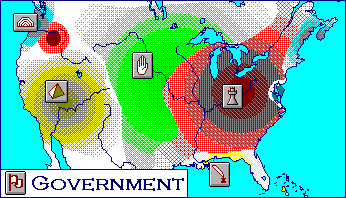
Gold = Hydraulic empires
Red = Feudal states
Green = Nomadic tribes
Yellow = Secretarial states
AFAICT the levels of shading show, broadly, how closely the indicated system is followed in each region. So coastal Texas is sort-of feudal, whatever that means... Jord's idea of Texas as a transitional zone makes sense.
For the empires, I used the shading to indicate more-or-less the zones of influence, yes; so solid gold is a pure imperial system with peasants bound to the land, forced to contribute crops and labor to their landowner and/or to the state. Shaded areas are the border regions where the state's control is less absolute. There are more freeholders and nomads living around, but they are still considered within the borders of the empire. Light gold shading indicates more indirect zones of influence, where there are tributary chiefs and vassals and so on.
I assumed that central Mexico would have a feudal structure. That may not be the case but it's a placeholder.
Looking at White's population map, I really do think that the Lower Colorado River would have a concentration of farmers and this is just an oversight caused by the original page's focus on the US borders.
Last edited:
What does blue represent? Thalassocracy?
Basically, yes. The site calls it "The Republic." The only one it describes in depth is the US remnant government. They all seem to be maritime city-states. And IMO there should be some in the upper Great Lakes as well.
I think I should not have put the green nomads coming so far south in Mexico. That northern part is more desert than I thought. Probably only desert scrubland type nomads, though it's not quite as bare-bones as in the Sonora. Probably small clans with a few animals, nothing more. Monterrey is probably still just a tiny point of trade.
Last edited:

The Free Zone's Government
Southern California is a religious state that has survived for centuries with basically no external threats. In this environment, its political system has had plenty of opportunity to go to seed. Its institutions have grown and spread theit tendrils into some odd places. The governing bodies, in a general sense, are called "the Church," but the term implies a certain streamlined unity that is not to be found in Southern California, where the Church is divided among a labyrinthian network of holy orders, temple cults, monastic communities and interlocking bureaucracies, each of them having an assortment of administrative responsibilities that have accumulated over time.
For example, the Keepers of the Shrine of the Pacific have as their primary responsibility the care of the great temple at Palos Verdes and its associated holy sites. Since time imemorial they have also supervised all the lighthouses north of their temple site, a fairly logical extension of their main job. But for generations they have also maintained the roads of the Los Angeles basin - the reasoning being that the roads' highest purpose is as tracks for pilgrims. In addition, the Shrine oversees all corvee labor in the Lands of San Bernardino and San Fernando, the reasoning being... well, at this point there is no real reasoning. The Keepers were given that responsibility a long time ago, and today they guard it jealously because it gives them prestige and access to resources. The golden spires of Palos Verdes sparkle above the hills, testifying to the importance and wealth of the Keepers of the Shrine. And the other religious orders of the nation are no different. Their duties are similar to those of the California Republic's departments of irrigation, collection, public works, etc., but these duties are divided in myriad ways among the different religious bodies.
Local administrators must manage the contact between these religious bodies and the land and people. The main unit of local government is the township, which consists of a central town and the surrounding fields. Southern California was once blanketed with towns, one crowding against the other, and most the modern townships take their names from these ancient suburbs, many claiming a direct line of continuity with them: Burbank, Pasadena, Anaheim, Irvine, and so forth. But most are now sleepy market villages, their only public buildings being a storehouse, mayoral hall, and a few shrines on the central square.
The aristocratic landowning families have plenty of opportunities to build bases of power. Great families have control of many religious posts and mayorships, making them essentially hereditary. But the corporate structures of the church bodies, and the division of power among them, prevents the aristocrats from challenging the power of the President. The President and his palace staff are the only institution that can coordinate and organize the Free Zone's confusing government. The system is not efficient, but it keeps the canals full and the fields planted, and the President rich and in command, so as long as attacks from over the mountains don't get too serious, efficiency is not necessarily that important. The highest governing body, called The Orgo, is a conclave of leaders of all major religious organizations in the country. This body is large enough that it does not meet very often.

The army and navy are the only aspect of administration whose control is centered entirely in the Presidency (with the exception of the forts at Santa Clarita, see below). These are entirely defensive in nature. Southern California's culture is not militaristic, and the life of the scribe and priest is praised more than that of the soldier. There are troops stationed at Ventura and the entrance to the Coachella valley, and a central army to protect the capital and put down insurrection. The navy is somewhat more able to project its power over a distance, but it too tends to stay in the Free Zone's waters, patrolling the spaces between the mainland and the Channel Islands.
Another word on the navy: as in the California Republic, the navy, or Shore, is used for training the highest-level priests and officials. But the Shore of the Free Zone has a much greater separation between its religious and defensive branches than you see in the Republic's Great Western Shore.
Geographic divisions
Mountain chains divide the empire into four "lands:" the Lands of Los Angeles, San Fernando, San Bernardino, and Ventura. The lands are important to administration in that most church bodies have different responsibilities in different lands, while others have their activities restricted to only one or two. The lands are also the basis for the judicial system: there are four Presidential Courts, one for each.
The District of Santa Clarita is an anomalous part of the Free Zone. It is a high basin in the mountains above the Lands of San Fernando and Ventura. It consists of a single township, and its land all belongs to a single family, which nowadays take their name from their estate. Located at the entrance to the main overland route into the California Republic, it is also a strategic spot; so the Clarita family also maintains a private military force and several fortresses to guard the pass. This makes Santa Clarita the only part of the empire that is essentially a feudal territory.
The Channel Islands are considered naval property, managed by different monastic orders that are couched within the navy's administrative structure. The islands, located out in the holy waters of the Pacific, are considered crucial to the health of the empire. The President makes an annual circuit to each one to perform the purification rituals that renew the whole country.
Finally, there are three vassal city-states to the south of the Free Zone's territory. All three look to the President as a spiritual and temporal sovereign while staying basically independent. They are Escondido, San Diego, and Ensenada. Escondido and Ensenada are small, hardscrabble agricultural towns of no particular value other than as a source of prestige for the President. San Diego's magnificent harbor makes it an important base for the navy to guard the Free Zone's southern flank. But the land around San Diego (and its neighbor, Tijuana) is rather poor, and it is not the great urban area that it was in former times.
Surrounding these regions are the forbidding deserts of Mojave and Baja California. These deserts supply certain minerals to the Free Zone but are otherwise uninhabitable. They, along with the mountains, insulate the country from the outside world and allow its people (and its aristocrats in particular) to continue to enjoy their way of life.
This map shows most of the townships of the Free Zone.
Last edited:
Bajo Colorado

The end of industrial civilization brought healing to the Colorado River delta, whose waters and wetlands are more-or-less back to their natural state after having been badly attenuated by dams, irrigation, and urban water needs. Today the delta supports a thriving community of farmers. The country's boundaries take in the Y-shaped fertile zone of the lower Colorado and the Imperial Valley as far as the Salton Sink, the Salton Sea having disappeared. The Gila River tributary supports farming communities that sometimes fall under Bajo Coloradan rule, sometimes under the rule of Phoenix (part of the New Mexican empire).
In terms of climate, Bajo Colorado is a full-blown desert; the people are absolutely dependent on the river for their water. So life there is always somewhat precarious; a few years of low waters can topple a dynasty.
Indeed, the regime of the last President Diaz collapsed some 40 years ago and since then the rulers of three separate cities have contended to replace him. The old capital of Guadalupe Victoria, located right in the crook of the Y, these days controls little beyond the wetlands of the delta. Rival powers in Mexicali and Yuma wage an on-and-off war to dominate the capital and thereby reunite the empire. Nomadic mercenaries brought in to fight in the war have settled down in the upper parts of the valleys, displacing many of the local farmers. At the moment, the country is in a state of peace, but without a President to rule over the valleys, everyone knows the land cannot be truly prosperous.
Bajo Coloradans daily see the interplay between fertility and barrenness, life and death. They know that life can bloom in the desert just as death can come unexpectedly in rich land. Their religion centers not on avoiding or appeasing the goddess of Holy Death, but on accepting, welcoming, and using her power. The most impressive feats of Bajo Coloradan architecture are the magnificent rock-cut tombs in the desert beyond the cultivated lands. The three petty dynasties that currently rule the country have maintained the tradition, and their tombs are no less grand than those of their predecessors.
Neighbors
Bajo Colorado lies between the Southern California Free Zone and the sprawling empire of New Mexico. Through the centuries, these three regions have tended to remain distinct, but there is also much interaction between them in the form of trade and warfare.
Trade with Los Angeles goes northwest through the San Gregonio Pass, a route that is fine for small merchant caravans and Biker convoys, but which is a forbidding obstacle to armies on the move. Attacks along this route have been rare but not unheard-of. Even campaigns of conquest have been recorded in the annals. In the years before the Free Zone separated from the Republic, a grand Californian army came down the pass, conquered the delta, and imposed Scientology on the people. Needless to say, it didn't take. Other instances of conquest - or armed diplomacy - have caused the formation of a two-headed kingdom in Los Angeles and the Delta; but this arrangement has rarely outlived its founders. Southern California and Bajo California have been separate and distinct for a very long time.
Other passes lead due west to the Free Zone's three vassal cities. The previous Dias dynasty frequently raided these three cities and sometimes imposed their rule overthem; nowadays attacks are smaller and infrequent, launched by the Mexicali clan. Many bands of Geeks come over the mountains. They are tremendously popular entertainers, even if the people do not fully understand the religious messages in the stories.
Up the Gila River are the New Mexican borderlands. Barges and raiding parties move in both directions. New Mexico could probably conquer the whole region if its President set out to do so, but then again, that might be just the thing to unite the feuding Bajo Coloradans.
The Gulf of California / Sea of Cortes is another great highway. Guadalupe Victoria is one of the main ports of entry for Mexican luxuries bound for the north.
Republic of Bajo Colorado:
Baja California

South of the Free Zone and Bajo Colorado stretches the rugged peninsula of Baja California, a harsh land of mountains and deserts that supports no human habitation larger than a temporary camp or seasonal rock shelter. The land is one of the most isolated in all of the Americas.
Its people, who number rather less than 100,000, speak a range of dialects descended from Spanish with significant English influence, and quite a lot of random evolution caused by isolation and cultural separation from those on the "mainland". They catch fish, hunt, gather, and keep small herds of cattle. They pray to natural spirits, but in their religious vocabulary and legends can clearly be seen memories of their Catholic ancestors. Very common is a 3-part cosmology emphasizing God (identified with the sea and sky), the Virgin (identified with the land and desert) and the Devil (identified with the volcanoes in the center of the peninsula, and with the harsh mountain terrain more generally). Some brave missionaries from California and Mexico can be found in the country at most times, living out in the wild among their converts. Catholic priests have made some headway, but scientology does very poorly out here.
At the southern extreme of the peninsula, the climate is wetter and the land is not so isolated. The city of La Paz is the capital of the small Free and Sovereign State of Baja California Sur, a cluster of settlements that support a lively commercial fishing industry. Sudcalifornian fishing fleets sail the entire gulf, supplying coastal Mexico with a substantial part of its protein needs. BCS is a vassal of the larger empire of Sinaloa.
Free and Sovereign State of Baja California Sur:
... With that, I think I am done with the Californias.
The end of industrial civilization brought healing to the Colorado River delta, whose waters and wetlands are more-or-less back to their natural state after having been badly attenuated by dams, irrigation, and urban water needs. Today the delta supports a thriving community of farmers. The country's boundaries take in the Y-shaped fertile zone of the lower Colorado and the Imperial Valley as far as the Salton Sink, the Salton Sea having disappeared. The Gila River tributary supports farming communities that sometimes fall under Bajo Coloradan rule, sometimes under the rule of Phoenix (part of the New Mexican empire).
In terms of climate, Bajo Colorado is a full-blown desert; the people are absolutely dependent on the river for their water. So life there is always somewhat precarious; a few years of low waters can topple a dynasty.
Indeed, the regime of the last President Diaz collapsed some 40 years ago and since then the rulers of three separate cities have contended to replace him. The old capital of Guadalupe Victoria, located right in the crook of the Y, these days controls little beyond the wetlands of the delta. Rival powers in Mexicali and Yuma wage an on-and-off war to dominate the capital and thereby reunite the empire. Nomadic mercenaries brought in to fight in the war have settled down in the upper parts of the valleys, displacing many of the local farmers. At the moment, the country is in a state of peace, but without a President to rule over the valleys, everyone knows the land cannot be truly prosperous.
Bajo Coloradans daily see the interplay between fertility and barrenness, life and death. They know that life can bloom in the desert just as death can come unexpectedly in rich land. Their religion centers not on avoiding or appeasing the goddess of Holy Death, but on accepting, welcoming, and using her power. The most impressive feats of Bajo Coloradan architecture are the magnificent rock-cut tombs in the desert beyond the cultivated lands. The three petty dynasties that currently rule the country have maintained the tradition, and their tombs are no less grand than those of their predecessors.
Neighbors
Bajo Colorado lies between the Southern California Free Zone and the sprawling empire of New Mexico. Through the centuries, these three regions have tended to remain distinct, but there is also much interaction between them in the form of trade and warfare.
Trade with Los Angeles goes northwest through the San Gregonio Pass, a route that is fine for small merchant caravans and Biker convoys, but which is a forbidding obstacle to armies on the move. Attacks along this route have been rare but not unheard-of. Even campaigns of conquest have been recorded in the annals. In the years before the Free Zone separated from the Republic, a grand Californian army came down the pass, conquered the delta, and imposed Scientology on the people. Needless to say, it didn't take. Other instances of conquest - or armed diplomacy - have caused the formation of a two-headed kingdom in Los Angeles and the Delta; but this arrangement has rarely outlived its founders. Southern California and Bajo California have been separate and distinct for a very long time.
Other passes lead due west to the Free Zone's three vassal cities. The previous Dias dynasty frequently raided these three cities and sometimes imposed their rule overthem; nowadays attacks are smaller and infrequent, launched by the Mexicali clan. Many bands of Geeks come over the mountains. They are tremendously popular entertainers, even if the people do not fully understand the religious messages in the stories.
Up the Gila River are the New Mexican borderlands. Barges and raiding parties move in both directions. New Mexico could probably conquer the whole region if its President set out to do so, but then again, that might be just the thing to unite the feuding Bajo Coloradans.
The Gulf of California / Sea of Cortes is another great highway. Guadalupe Victoria is one of the main ports of entry for Mexican luxuries bound for the north.
Republic of Bajo Colorado:
- System of Government: Hydraulic Empire
- Head of State: President, currently a vacant throne
- Population: 500,000
- Religion: Catholic Church of Holy Death
- Totemic Symbol: crowned skull and bones
Baja California
South of the Free Zone and Bajo Colorado stretches the rugged peninsula of Baja California, a harsh land of mountains and deserts that supports no human habitation larger than a temporary camp or seasonal rock shelter. The land is one of the most isolated in all of the Americas.
Its people, who number rather less than 100,000, speak a range of dialects descended from Spanish with significant English influence, and quite a lot of random evolution caused by isolation and cultural separation from those on the "mainland". They catch fish, hunt, gather, and keep small herds of cattle. They pray to natural spirits, but in their religious vocabulary and legends can clearly be seen memories of their Catholic ancestors. Very common is a 3-part cosmology emphasizing God (identified with the sea and sky), the Virgin (identified with the land and desert) and the Devil (identified with the volcanoes in the center of the peninsula, and with the harsh mountain terrain more generally). Some brave missionaries from California and Mexico can be found in the country at most times, living out in the wild among their converts. Catholic priests have made some headway, but scientology does very poorly out here.
At the southern extreme of the peninsula, the climate is wetter and the land is not so isolated. The city of La Paz is the capital of the small Free and Sovereign State of Baja California Sur, a cluster of settlements that support a lively commercial fishing industry. Sudcalifornian fishing fleets sail the entire gulf, supplying coastal Mexico with a substantial part of its protein needs. BCS is a vassal of the larger empire of Sinaloa.
Free and Sovereign State of Baja California Sur:
- System of Government: Hybrid of hydraulic empire and maritime republic
- Head of State: Governor, selected by lot from among the heads of 5 leading clans, and subject to veto from Sinaloa
- Population: 75,000
- Religion: Catholic Church (Sinaloan tradition)
- Totemic Symbol: Scallop shell
... With that, I think I am done with the Californias.
Last edited:
Was anything said about the remnant government of the United States
At this point, there is only the original source material: http://users.erols.com/mwhite28/medvam/usa.htm
Since jmberry wanted to basically move "left to right" through the US and Canada, then do the rest of the world, we had not gotten that far yet. But he also said we're ready to do the rest of the continent at this point.
Last edited:
Village priests and the Holy Letters
In great matters of religion, the Californian elite manages everything; they keep the land healthy and fertile and ward off disasters, and they keep the souls of the people on the path toward enlightenment. Ordinary people just need to keep working for their superiors, and they can rest easy knowing that their own souls are Clear.
However, in the small matters of day-to-day life, the people still have spiritual needs. Every peasant village has a holy man or woman who can intercede with the spiritual world seeking healing and good fortune. These peasant-priests are all licensed by the state. In the Republic they must receive confirmation by the Dianetician, the member of the lower priesthood who mainly is concerned with Clearing people at the beginning and end of life, and for generally regulating religious practice within his district. In the Free Zone, village healers may be certified by any number of priestly orders that are active throughout the country.
Both the Dianeticians and the healers make use of ritual objects of various kinds. Some resemble paddles that are passed over a person to ward off evil. Others must be worn as amulets or placed in the patient's hand. All of these items are richly decorated and make use of copper and bronze inlay, metals believed to have properties that can sense and conduct the body's energy.
Holy men and women also learn the rudiments of writing, mostly for inscribing set incantations on the ritual objects or on items like plows and craftsmen's tools, for which their owners want a blessing. These incantations are in the old English language of the scriptures. For writing and inscribing it, Californians have developed an angular runic alphabet. The runes can be easily carved into wood without carving along the grain; thus, they consist only of straight vertical and diagonal lines. Most begin with one or two vertical stems to which are added diagonal branches. Four letters (C, O, V, and X) consist only of diagonals.
Last edited:
The runes can be easily carved into wood without carving along the grain; thus, they consist only of straight vertical and horizontal lines. Most begin with one or two vertical stems to which are added diagonal branches. Four letters (C, O, V, and X) consist only of diagonals.
Should that not be "straight vertical and diagonal lines" instead?
Should that not be "straight vertical and diagonal lines" instead?
Yes, that's right.
Share: