Base Maps from 550 BC to Modern Day, all in UCS!

Status
Not open for further replies.
Nope. Sorry pal. They seem to be on hiatus at the moment :eek:
ALrighty, no big deal. I see Helios is working on the 1885 one, so I'll just lurk until he gets it done lol.

Is anybody ever planning on putting together a giant list of the maps done, like what was done in the first few pages of this thread?
 
Adding my offhand knowledge about Madagascar to the 1885 map:

pRNAR.png


(Someone might have to double-check the Kerguelens, though.)
 
I tried to help, too. Gave Morocco independence, put South Sakhalin back under Russian control and I changed the Korean situation (though I'm not sure what the actual situation was regarding China and Korea, so I just gave it independence while keeping a Chinese claim on the area). I hope it'll help.

Oh, and though I didn't fix it, the German-French border in Cameroon and French Congo is certainly wrong. The region called 'Neukamerun' should be French on this map, as it wasn't given to Germany until 1911. I also gave Helgoland to Britain since there was a trade involving it and Zanzibar (although I wasn't sure of the exact specifics, so I gave Zanzibar the German protectorate colour but someone more knowledgeable should probably confirm whether it's right). Iran should probably be different as the current settlement was, as far as I know, agreed upon in 1907 when the Anglo-Russian Entente was formed. I also gave Guam and Puerto Rico to Spain, colored Wake island non-claimed green and coloured Hawaii white.

Also, when in 1885 is this map supposed to be? If it is at the start, then the Congo Free State (which I outlined in white for you) and probably a lot of other African colonies shouldn't exist, but if it's near the end, then Bulgaria and Eastern Rumelia should probably be unified.

Finally... what is up with those Norwegian and Finnish colours?

1885.PNG
 
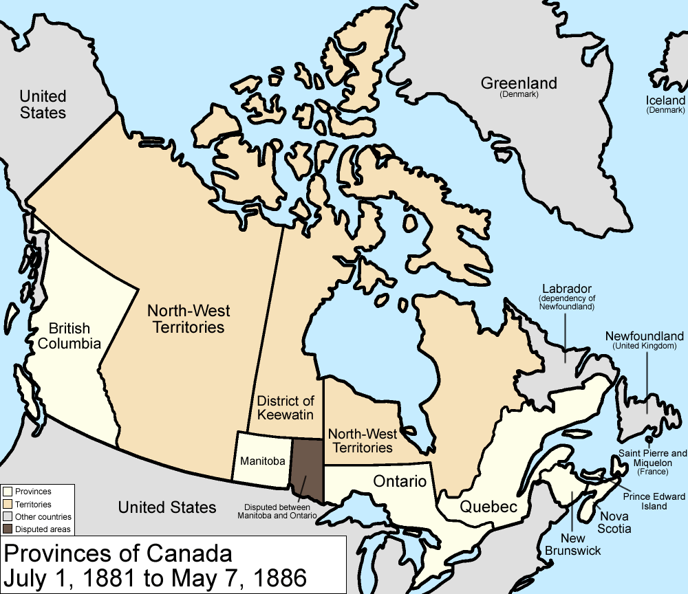
The borders of the Canadian Provences are not right
Canada_provinces_1881-1886.png

Their is also a provisional government of Saskatchewan that is in rebellion.

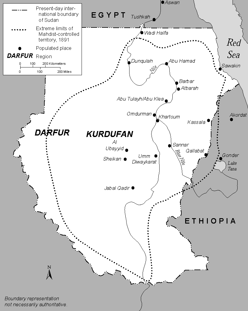
Also the Maddest rebellion is occurring in the Soudan
The_Mahdist_State%2C_1881-98%2C_modern_Sudan.png
 
Adding my offhand knowledge about Madagascar to the 1885 map:

(Someone might have to double-check the Kerguelens, though.)

I tried to help, too. Gave Morocco independence, put South Sakhalin back under Russian control and I changed the Korean situation (though I'm not sure what the actual situation was regarding China and Korea, so I just gave it independence while keeping a Chinese claim on the area). I hope it'll help.

Oh, and though I didn't fix it, the German-French border in Cameroon and French Congo is certainly wrong. The region called 'Neukamerun' should be French on this map, as it wasn't given to Germany until 1911. I also gave Helgoland to Britain since there was a trade involving it and Zanzibar (although I wasn't sure of the exact specifics, so I gave Zanzibar the German protectorate colour but someone more knowledgeable should probably confirm whether it's right). Iran should probably be different as the current settlement was, as far as I know, agreed upon in 1907 when the Anglo-Russian Entente was formed. I also gave Guam and Puerto Rico to Spain, colored Wake island non-claimed green and coloured Hawaii white.

Also, when in 1885 is this map supposed to be? If it is at the start, then the Congo Free State (which I outlined in white for you) and probably a lot of other African colonies shouldn't exist, but if it's near the end, then Bulgaria and Eastern Rumelia should probably be unified.

Most of Africa was still uncolonised in 1885. That was when the Berlin Conference was held. Norway should be a part of Sweden, too. There's more wrong with it, but I just got out of bed :eek:
 
Using a 20th century map as a starting point for a 19th century map is not a good idea.

You're better off starting with the last 1860's map.

Actually, give me awhile and I'll do an 1885 one.
 
Last edited:
Ok, so I've finished Canada (among other places), but I'm not happy with the borders of the District of Kivalliq (I know they're off, but the map projections are screwing up my interpretation) and, while I've done som corrections to Quebecs Northern border I'm still not realy happy with it either (I was using the original series border for it previously), so if anyone wants to have a go at correcting them, do feel free to.

1885 Canada.png
 
As people have said, Africa is way off. The general terribleness of the map is why I put WIP in the filename and wrote Work In Progress on the ocean. Just to make it clear that it isn't quite right to anyone who finds it and thinks its accurate.

ALrighty, no big deal. I see Helios is working on the 1885 one, so I'll just lurk until he gets it done lol.

Is anybody ever planning on putting together a giant list of the maps done, like what was done in the first few pages of this thread?

I like to think I launched a collaboration for 1885. :p
That would be an excellent idea.

Also, when in 1885 is this map supposed to be? If it is at the start, then the Congo Free State (which I outlined in white for you) and probably a lot of other African colonies shouldn't exist, but if it's near the end, then Bulgaria and Eastern Rumelia should probably be unified.

Finally... what is up with those Norwegian and Finnish colours?

I believe all unspecified maps are supposed to be January 1 of that year. Though I think an different date should be specified given events in Africa and Indochina. (France finished up a war there, right?)
As I recall Bulgaria and Eastern Rumelia unified in... 1908?
Norway is in personal union with Sweden, and to quote my copy of the Richardean Colour Scheme, "If one partner is dominant, use vassal coloration on the other." I believe that would reference Sweden's protectorate color.
As for Finland, for some reason I changed it to Russia's protectorate color. Dominion seems more appropriate, though I'm not sure.

Using a 20th century map as a starting point for a 19th century map is not a good idea.

You're better off starting with the last 1860's map.

Actually, give me awhile and I'll do an 1885 one.

I couldn't find the 1860s one. I made due with what I had.

Ok, so I've finished Canada (among other places), but I'm not happy with the borders of the District of Kivalliq (I know they're off, but the map projections are screwing up my interpretation) and, while I've done som corrections to Quebecs Northern border I'm still not realy happy with it either (I was using the original series border for it previously), so if anyone wants to have a go at correcting them, do feel free to.
Patched in.
1885 WIP.png

1885 WIP.png
 
I did some updates to 1925 and 1950.

Note that there are some improvements to the basemap. Courland is actually much larger than the new version showed it, and I also modified Lake Ladoga and Onega, one of which was too small and the other somewhat off, as well as Denmark. I didn't add some of the new lakes including the Russian reservoirs yet, mostly because I'm still going over them. The Volgograd reservoir in particular doesn't seem to be nearly as wide/large as it is shown here, nor is Lake Balaton (something which I think has been brought up before).

1950:
- Showed the International Authority for the Ruhr:
http://en.wikipedia.org/wiki/International_Authority_for_the_Ruhr

195020globe20latest.png
 
1925:
- Australian New Guinea consisted of two territories.
- the Libya-Egypt border was further west at the time
- added the districts of French Syria, which included Hatay.
- the Memel territory was autonomously governed by Lithuania since 1923.
- The Rhineland was still occupied (until 1930) and demilitarized (until 1936).
- The Soviet SSRs are shown in their 1925 borders.
- The Saud dynasty was still in the process of consolidating their control of the Arabian peninsula.

I added black borders for the different colonies because it was impossible to identify what are actually single administrative entities, such as the client kingdoms in Uganda, and the coastal (French metropolitan) and Saharan sectors of French Algeria.

Depending on the time of the year, Albania could be either a de facto Italian protectorate (as the Republic of Albania, established in 1925) or virtually autonomous (as the Principality of Albania). I’m also a bit unsure about Germany’s claims to Upper Silesia. I know that Germany renounced all its territorial claims stipulated at Versailles (although revisionist ambitions still ran high) and while the Silesian plebiscites weren’t part of it I don’t think they ever reactivated their claims.

sregan20enhanced20map20.png
 
As people have said, Africa is way off. The general terribleness of the map is why I put WIP in the filename and wrote Work In Progress on the ocean. Just to make it clear that it isn't quite right to anyone who finds it and thinks its accurate. I like to think I launched a collaboration for 1885. :p
That would be an excellent idea. I believe all unspecified maps are supposed to be January 1 of that year. Though I think an different date should be specified given events in Africa and Indochina. (France finished up a war there, right?)
As I recall Bulgaria and Eastern Rumelia unified in... 1908?
Norway is in personal union with Sweden, and to quote my copy of the Richardean Colour Scheme, "If one partner is dominant, use vassal coloration on the other." I believe that would reference Sweden's protectorate color.
As for Finland, for some reason I changed it to Russia's protectorate color. Dominion seems more appropriate, though I'm not sure.


I couldn't find the 1860s one. I made due with what I had.


Patched in.

It's still not right. Vassal colouration is not protectorateship, as that is a completely different form of governance (I find it maddening that people can't make the distinction). Finland vs. Russia (in 1914 maps, not yours) is more like vassalage in the sense described according to the key.

And as you said, Africa is wrong wrong wrong considering they hadn't even defined where the borders would be if they had any until that year.
 
I believe all unspecified maps are supposed to be January 1 of that year. Though I think an different date should be specified given events in Africa and Indochina. (France finished up a war there, right?)
December 31 would make more sense, really. Unless noted or implied otherwise (like maps of major events - 1914 is pre-wwi so set in July of that year, 1815 is after Vienna, etc.), people are usually going to assume that a map of a specific year will represent the historical events and changes which occured in those twelve months. Setting them at January 1 effectively makes them maps of the previous year.
 
Last edited:
Ok, so I've finished Canada (among other places), but I'm not happy with the borders of the District of Kivalliq (I know they're off, but the map projections are screwing up my interpretation) and, while I've done som corrections to Quebecs Northern border I'm still not realy happy with it either (I was using the original series border for it previously), so if anyone wants to have a go at correcting them, do feel free to.
Judging by that map 1930sman posted Keewatin's border seems to touch the Arctic Ocean in between Victoria and King William island. Here's a more meridional version:

188520canadameridionalb.png
 
Judging by that map 1930sman posted Keewatin's border seems to touch the Arctic Ocean in between Victoria and King William island. Here's a more meridional version:

188520canadameridionalb.png

Yeah, the projections are really hard to translate.

Looking at it I think the Northern border is actualy further East though, like the below;

Keewatin.png
 
Africa sort of improved in that i wiped out most colonies. I took a crack at the Mahdist Rebellion and included the Pink Map claims. I think I have the mentioned bits of the Pacific right. Reintroduced Hong Kong and Macau. Gave Morocco Rio de Oro, though that's probably wrong. I left French color on Senegal because they definitely had a presence on some of the coast.
Africais still a mess though.

It's still not right. Vassal colouration is not protectorateship, as that is a completely different form of governance (I find it maddening that people can't make the distinction). Finland vs. Russia (in 1914 maps, not yours) is more like vassalage in the sense described according to the key.

And as you said, Africa is wrong wrong wrong considering they hadn't even defined where the borders would be if they had any until that year.

Fixed, maybe.

December 31 would make more sense, really. Unless noted or implied otherwise (like maps of major events - 1914 is pre-wwi so set in July of that year, 1815 is after Vienna, etc.), people are usually going to assume that a map of a specific year will represent the historical events and changes which occured in those twelve months. Setting them at January 1 effectively makes them maps of the previous year.
That makes a lot of sense to me.

1885 WIP.png

1885 WIP.png
 
This is what Sweden and Finland should look like, as they always have been:

Edit: For anyone wondering, Finland is not but an autonomous region within the Russian Empire, while Sweden-Norway was a union of crowns, much like England and Scotland (but I think less integrated).

1885 Europe.png
 
I'm working on Africa in 1885 right now, but i need some informations about english colonies statutes, in South Africa, in Arabia and Egypt (Nubia, English Sudan, Darfour)

For the Congo Free State, someone have a good map?

EDIT : Here's North Africa. The yellow line is apparently or egyptian territory, or influenced one.

EDIT : Abyssinia is an absolute hell.

dddd.png
 
Last edited:
EDIT : Here's North Africa. The yellow line is apparently or egyptian territory, or influenced one.

I think that may have been an attempt to show the British influence around the entrance to the Suez Canal, either that or it's just an error in the map.


EDIT : Abyssinia is an absolute hell.

At that time it was just the blue-grey triangle, Ethiopias modern borders are essentially near the largest it's ever been throughout its entire history.
 
Top
Status
Not open for further replies.
Top