New Netherlands remains Netherlands

  • Thread starter Deleted member 2186
  • Start date

Deleted member 2186

What if New Netherlands which remained part of the Dutch Republic due the English invasion fleet in 1664 was sunk in a storm before they could invade the Netherlands colony,wich resulted in this map and some other things I have so far created related to it.

I now that many borders look like OTl but this is my first real map I have ever made.

North_america_blank_range_map-2.png


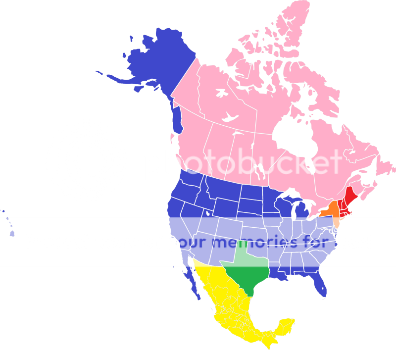
The nations are shown by color

Orange

Kingdom of New Netherlands

Official language(s): Netherlands (de facto) English and French regionally.
Capital: New Amsterdam
Largest city: New Amsterdam, 7,457,995
Government: Parliamentary democracy under a constitutional monarch.
Currency:Nieuw Nederlandse gulden
Current Population :17,639,307
Establishment: province status in 1624, Independence from the Batavian Republic in 1795, became a country within the United Kingdom of the Netherlands in 1815.

Green

Republic of Texas

Official language(s): English (de facto), Spanish and French regionally.
Capital: Houston
Largest city: Houston, 384,514
Government: Republic.
Currency:Texas Dollar
Current Population :6,714,824
Independence from Mexico: 1836 recognized in 1837 by the United States of America.


Red

Commonwealth of New England

Official language(s): English (de facto) with Netherlands and French regionally.
Capital:Boston
Largest city: Boston, 770,816
Government: Federal parliamentary democracy.
Currency:New England Dollar
Current Population :8,437,290
Independence from the United States of America: 1805 recognized in 1810.

Blue

The United States of America consist of 38 states and three territories.

United States of America

Official language(s): English (de facto)
Capital: Washington, DC.
Largest city: Chicago 3,396,808,
Government: Federal presidential constitutional republic.
Currency:United States Dollar
Current Population : 91,371,203
Independence from the Kingdom of Great Britain: 1776 recognized in 1785.

Yellow

United Mexican States

United Mexican States was formed in 1810 and has fought two wars whit the United States of America and several wars ranging from full scale to border wars with its main rival the Republic of Texas.

Official language(s): Spanish
Capital: Mexico City
Largest city: Mexico City
Government: Federal presidential constitutional republic.
Currency:Mexican peso
Current Population :18,000,000
Independence from Spain: 1810 recognized in 1821.

Pink

Canada

Official language(s): English and French
Capital: Ottawa
Largest city: Toronto
Currency: Canadian dollar
Current Population :11,382,000
Government: Federal parliamentary democracy and constitutional monarchy.
 
Last edited by a moderator:

Deleted member 2186

Director-Generals and Prime Ministers of New Netherlands

Director General

Cornelis Jacobszoon, 1624 to 1625.

Willem Verhulst, 1625 to 1626.

Peter Minuit, 1626 to 1632.

Sebastiaen Jansen Krol , 1632 to 1633.

Wouter van Twiller, 1633 to 1638.

Willem Kieft, 1638 to 1647.

Petrus Stuyvesant, 1647 to 1672, died in office.

Cornelis Jacobsz Steenwijck, 1672 to 1680.

Albert Janse Ryckman, 1680 to 1690, first person born in the colony of New Netherland to be made Director-General of New Netherland.

Abraham van Vredenburg 1690 to 1705, served first as Governor of Netherlands-Suriname.

Paul van der Veen Doens, 1705 to 1715.

Pieter Van Brugh, 1723 to 1728.

Francis Anthonie de Rayneval, 1728 to 1738, served first as Governor of Netherlands-Suriname.

Cortlandt Skinner, 1754 to 1771, was twenty-seven when he became Director-General of New Netherland.

Peter Van Brugh Livingston, 1771 to 1777.

Pierre Van Cortlandt, 1777 to 1795 was the last Director General, offices replaced by that of Prime Minster.

Prime Ministers

When Napoleon Bonaparte seized the Netherlands in 1795, Director-General Pierre Van Cortlandt assumed administrative control of the colonies of New Netherlands and when the Kingdom of New Netherland was proclaimed the office of Director General was replaced by that of Prime minster.

Stephen Van Rensselaer, 1795 to 1803, first Prime minster of the Kingdom of New Netherlands, serving two terms.

Jeremiah Van Rensselaer, 1803 to 1810, died in office during his third term.

DeWitt Clinton, 1810 to 1818, was elected into office in a special election.

Herman Knickerbocker, 1818 to 1826, served two terms in office.

Martin Van Buren, 1837 to 1857, first Prime minster to serve five terms in office.

Robert Campbell, 1857 to 1861, first Prime Minster to serve only one term in office.

Charles Benedict Calvert, 1861 to 1865, second Prime Minster to serve only one term in office.

Schuyler Colfax, 1865 to 1877, served three terms in office.

Theodore Fitz Randolph, 1877 to 1885, served two terms in office.

Leon Abbett, 1885 to 1889, third Prime Minster to serve only one term in office.

George Craig Ludlow, 1889 to 1897, served two terms in office.

Theodore Roosevelt, 1897 to 1918, second Prime minster to serve five terms in office.

M. William Bray, 1918 to 1922, fourth Prime Minster to serve only one term in office.

Robert F. Wagner, 1922 to 1930, served two terms in office.

Franklin D. Roosevelt, 1930 to 1940, the current Prime minster of New Netherlands, now in his third term in office.
 

Deleted member 2186

List of Presidents of the United States of America

George Washington, 1789 to 1797.

John Adams, 1797 to 1801.

Thomas Jefferson, 1801 to 1809.

James Madison , 1809 to 1817.

James Monroe, 1817 to 1825.

Andrew Jackson, 1825 to 1837, first president to serve three terms in office.

Richard Mentor Johnson, 1837 to 1841.

William Henry Harrison , 1841, died in office.

John Tyler, 1841 to 1845.

James Knox Polk, 1845 to 1849.

Zachary Taylor, 1849 to 1850, died in office.

James Buchanan, Jr, 1850 to 1853.

Lewis Cass, 1853 to 1857.

James Buchanan, 1857 to 1861.

Abraham Lincoln, 1861 to 1865, was assassinated while in office.

Andrew Johnson, 1865 to 1869.

Ulysses Simpson Grant, 1869 to 1877.

Rutherford Birchard Hayes, 1877 to 1881.

Winfield Hancock, 1881 to 1885.

James G. Blaine, 1885 to 1889.

Benjamin Harrison, 1889 to 1897.

William Jennings Bryan, 1897 to 1901.

William McKinley, Jr., 1901 to 1909.

William Howard Taft, 1909 to 1913.

Woodrow Wilson, 1913 to 1921.

Calvin Coolidge 1921 to 1929, second president to serve three terms in office.

Herbert Clark Hoover, 1929 to 1937.

Alf Landon, 1937 to 1940, current president of the United States of America.
 

Deleted member 2186

List of Presidents of the Republic of Texas

Constitution of the Republic of Texas of 1836 specifies a term of two years for the first elected President (Sam Houston) and terms of three years thereafter; while the President cannot succeed himself, there are otherwise no term limits in place.

1st David G. Burnet, March 16th 1836 to October 22nd 1836.

2nd Sam Houston, 1836 to 1838, constitution specified a term of two years for the first elected President.

3rd Mirabeau B. Lamar, 1838 to 1841.

4th Sam Houston, 1841 to 1844, second term as president.

5th Anson Jones, 1844 to 1846.

6th Sam Houston, 1846 to 1849, third term as president.

7th John Alexander Greer, 1849 to 1851.

8th James Wilson Henderson, 1851 to 1854.

9th Elisha Marshall Pease, 1854 to 1857.

10th Sam Houston, 1857 to 1860, fourth term as president.

11th Edward Clark 1860 to 1863.

12th Francis Richard Lubbock, 1863 to 1866.

13th Elisha Marshall Pease, 1866 to 1869, second term as president.

14th Richard Coke, 1872 to 1875.

15th Richard B. Hubbard, 1875 to 1878.

16th Oran Milo Roberts, 1878 to 1881.

17th Richard Coke, 1881 to 1884, second term as president.

18th John Ireland, 1884 to 1887.

19th Lawrence Sullivan Ross, 1887 to 1890.

20th James Stephen Hogg, 1890 to 1893.

21st George Cassety Pendleton, 1893 to 1896.

22nd Joseph D. Sayers, 1896 to 1899.

23rd James Nathan Browning, 1899 to 1902.

24th Thomas Mitchell Campbell, 1902 to 1905.

25th Oscar Branch Colquitt, 1905 to 1908.

26th Thomas Mitchell Campbell, 1908 to 1911, second term as president.

27th Oscar Branch Colquitt, 1911 to 1914, second term as president.

28th James E. Ferguson, 1914 to 1917.

29th William P. Hobby Sr, 1917 to 1920.

30th Pat Morris Neff, 1920 to 1923.

31st Thomas Whitfield Davidson, 1923 to 1926.

32nd Dan Moody, 1926 to 1929.

33rd Ross S. Sterling, 1929 to 1932.

34th Edgar E. Witt, 1932 to 1935.

35th James V. Allred, 1935 to 1938.

36th Coke R. Stevenson, 1939 to 1940, current President of the Republic of Texas.
 
What if New Netherlands which remained part of the Dutch Republic due the English invasion fleet in 1664 was sunk in a storm before they could invade the Netherlands colony,wich resulted in this map and some other things I have so far created related to it.

I now that many borders look like OTl but this is my first real map I have ever made.

I really love the idea of a Dutch New Netherlands and I am one its greatest defenders on the board. The thing is, a surviving New Netherlands would change a lot of the balance of power in Northern America. For example, with a foreign country dividing the English colonies, would mean a lot of difference during the Anglo-French wars of the 17th and 18th century. Certainly the 7 year war would play out differently, as the Dutch weren't involved in it (this is asuming it won't be butterflied away, which is certainly possible). This could lead to a surviving French Quebec and so possibly butterfly away the American revolution. I can't see New England revolting with the French army in their backs. Also, if the British do capture Canada, being divided by a foreing colony, means that New England and the southern colonies will develop differently. Maybe one of them revolts, while the other doesn't. If both do, it will be easier for the British to defeat, (devide and conquer).

In my opinion, a surviving new Netherlands (but a surviving French Quebec would have the same result) would change north American history almost unrecognisable.
 

Deleted member 2186

Thanks for liking the idea so far.


13coloniesbw-1.gif


The Twelve British colonies in North America 1607 to 1776

The Twelve Colonies were established by Great Britain on the Atlantic coast of North America between 1607 and 1733.

In 1776 they declared their independence and formed the United States of America.

New England Colonies

Province of New Hampshire, later New Hampshire
Province of Massachusetts Bay, later Massachusetts and Maine
Colony of Rhode Island and Providence Plantations, later Rhode Island
Connecticut Colony, later Connecticut

Middle Colonies

Province of Vermont, later Vermont
Province of Pennsylvania, later Pennsylvania
Delaware Colony, later Delaware.

Southern Colonies

Province of Maryland, later Maryland
Colony and Dominion of Virginia, later Virginia, Kentucky and West Virginia
Province of North Carolina, later North Carolina and Tennessee
Province of South Carolina, later South Carolina
Province of Georgia, later Georgia, Alabama and Mississippi
 
Province of Vermont, later Vermont
Province of Pennsylvania, later Pennsylvania
Delaware Colony, later Delaware.

First of all wasn't Delaware also part of the New Netherlands, at least partially? Secondly I believe that Vermont basicly grew out of border between New York and other colonies. If New York remains Dutch, I don't think a new state will be made out of it. Thirdly I really doubt that without New York and New Jersey there will be middle colonies, certainly not split in the middle by a foreign colony. I think Vermont (if it exists) will be added to New England and Delaware (if it is British) and Pensylvania will be part of the southern colony.
 
In my opinion, a surviving new Netherlands (but a surviving French Quebec would have the same result) would change north American history almost unrecognisable.


This. A differing colonial pattern for North America should result in fascinating changes, yet nothing really changes ITTL.

The idea suggested by the OP's "map" that a New Netherlands which remains in the hands of the Dutch would result in many nations, states, and provinces of North America having the same borders as they do in the OTL is complete nonsense. The idea that well after the POD the same people would be born and come to prominence ITTL as were born and came to prominence in the OTL is complete nonsense too.

This time line just isn't bad, this time line betrays an incomprehension of the basic tenet of alternate history: Changes beget changes.
 
Nice idea, but i guess if Texas didn't join USA probably it will occupied at least New Mexico and Arizona...:confused:
 

Deleted member 2186

Nice idea

Thanks but I begin to think if I should post the other stuff I have created here, if the map I have made is already considered to OTL, then the stuff related is also not that good.
 

Deleted member 2186

Ok despite the map being too much like OTL I have decided to keep it this way but I want to publish a list of cities in New Netherlands in the year 1940.

Cities in New Netherlands 1940

New Amsterdam (OTL New York), 7,457,995, founded in 1625.

Buffalo, 575,901.

Newark 429,760 was founded in 1666 by English colonist who left New Haven Colony in the English Colony of Connecticut.

Pavonia (OTL Jersey City), 301,173.

Colen Donck (OTL Yonkers city), 142,598.

Cornelis (OTL Paterson), 139,656, named after the first Director-General of New Netherland.

Elizabeth, 109,912, founded by the English in 1665 and captured by the Dutch during the third Anglo–Dutch War in 1672 and transferred to the Dutch Republic with the Treaty of Westminster of 1674 where the borders of most of New Netherlands where put down by both the Dutch Republic and the kingdom of England.

Beverwijck (OTL Albany City) 130,577.

Trenton, 124,697, settled by Quakers in 1679 who were being persecuted in England and New Netherlands providing the perfect opportunity to exercise their religious freedom.

New Amstel (OTL Camden City), 117,536.

Utica, 100,518, settled by New Netherlands Dutch and English colonist in 1773, on the site of Fort Schuyler named after Colonel Philip Schuyler, a hero of the French and Indian War.

Schenectady, 87,549, first settled in 1661.

Chenango-Binghamton (OTL Binghamton), 78,309.

Niagara Falls, 78,020.

Rensselaerswyck (OTL Troy), 70,304.

Mount Vernon, 67,362.

Atlantic Stad (OTL Atlantic City), 64,094.

New Rochelle, 58,408, was founded in 1688 by French Protestants who fled persecution in France.

Wiltwijck (OTL Kingston, New york)

The city Wiltwijck was settled in 1651, it was one of the three large North River (OTL Hudson River) settlements in New Netherlands at that time together with Beverwyck and New Amsterdam.

Schuyler (OTL Kearny, New Jersey)

The town of Schuyler is named after Captain Arent Schuyler, a former Dutch trader and Indian Agent.

As by 1940 the population of the town of Schuyler is 39,467.
 

Deleted member 2186

Civil Airports in the Kingdom of New Netherlands

Newark Airport

Newark Airport was the first major airport in the Kingdom of New Netherlands , opening on October 1, 1928.

In 1935 the Newark Airport Administration Building, which was North America's first commercial airline terminal opened.

Newark was the busiest airport in the world until New Amsterdam Municipal Airport opened in 1939, dividing New Amsterdam air traffic.

In end of May 1940, Newark Airport was closed to passenger traffic and taken over by the Royal New Netherlands Army for logistics operations in the support of the war in Europe.

New Amsterdam Municipal Airport

New Amsterdam Municipal Airport was dedicated on October 15, 1939, and opened for business on December 2, 1939. It cost the city of New Amsterdam City, 23,000,000 Nieuw Nederlandse guldens to turn a tiny airport into a 550-acre (2.2 km2) modern facility.

From its opening on December 2, 1939 onwards the citizens of the city of New Amsterdam have become fascinated by the very idea of air travel, and thousands have travel so far to the airport, paying dime fee, and watching airliners take off and land. A year sins its opening these fees and their associated parking have already provided 142,500 Nieuw Nederlandse guldens, while another non-travel related incomes (food, etc.) have provided an additional 325,000 Nieuw Nederlandse guldens.

New Amsterdam Municipal Airport has become the busiest civilian airfield in the Kingdom of New Netherlands, sins the closing of Newark Airport by the Royal New Netherlands Army for passenger traffic.

Theodore Roosevelt Airport

Originally named the Heemstede Plains Aerodrome, it was renamed in honor of former Prime Minster Theodore Roosevelt after his death in 1924.

The Heemstede Plains Aerodrome, originally encompassed 900 to 1,000 acres (405 ha) ,When in 1914 the New Netherlands military began using the Heemstede Plains field as a training center for military pilots it was renamed Hazelhurst Field. From 1918 onwards the New Netherlands Air Service authorized some companies to operate from Hazelhurst Field until July 1, 1920, at which time the government sold its buildings and improvements and relinquished control of the field. On September 24, 1924, the airfield name was changed to Roosevelt Field.

At its peak in the 1930s, it was New Netherlands busiest civilian airfield until the opening of Newark Airport and later on New Amsterdam Municipal Airport.

While one part of Theodore Roosevelt Airport is used as a civilian airfield another part is used by the Royal New Netherlands Army Air Force and the Royal New Netherlands Naval Aviation Service.

Flushing Airport

Flushing Airport is an airfield located in Flushing, a neighborhood in the north central part of the city of New Amsterdam, The airfield began operating in 1927. It was one of the busiest airports in the city of New Amsterdam before the emergence of the larger New Amsterdam Municipal Airport.

Beverwijck International Airport

Beverwijck International (OTL Albany International Airport) was the first, and remains the oldest, municipal airport in the Kingdom of New Netherlands and has been operating sins 1908.

Buffalo Municipal Airport

Built in 1926, Buffalo Municipal Airport is one of the oldest public airports in the Kingdom of New Netherlands.

Civil ports in the Kingdom of New Netherlands

New Amsterdam harbor

In 1624 the first permanent European settlement was started on Noten Eylandt (OTL Governors Island), and eight years later in Breuckelen (OTL Brooklyn); soon these were connected by ferry operation. The Director-General of New Netherland, Peter Stuyvesant, ordered construction of the first wharf on the Manhattan bank of the lower East River sheltered from winds and ice, which was completed late in 1648 and called Schreyers Hook Dock. This prepared New Amsterdam as the main port in the colony New Netherland of colonies and then within the newly independent Kingdom of New Netherlands. In 1686 the Dutch Director-General of New Netherland gave the city of New Amsterdam control over the waterfront.

Canals

In 1824 the first New Netherland drydock was completed on the East River. Because of its location and depth, the Port grew rapidly with the introduction of steamships; and then with the completion in 1825 of the Erie Canal, New Netherlands became the most important transshipping port between the American interior and Europe as well as coastwise destinations. By about 1840, more passengers and a greater tonnage of cargo came through the port of New Amsterdam than all other major harbors in the North American continent combined and by 1900 it was one of the great international ports. The Morris Canal, carrying anthracite and freight from the U.S state of Pennsylvania through New Netherlands to its terminus at the mouth of the North River (OTL Hudson) in Pavonia (OTL Jersey City).

Railroad terminals

By the beginning of the 1900s numerous railroad terminals lined the western banks of the North River, transporting passengers as well as freight from all over the North American continent. The freight was ferried across by the competing railroads with small fleets of towboats, barges, and car floats, specially designed barges with rails so cars could be rolled on. The city of New Amsterdam subsidies this service which is undercutting rival ports, from New Netherlands to as far as the Republic of Texas.

Port of Beverwijck–Rensselaer

Since the founding of Beverwijck (OTL Albany City) in 1624 as a trading post, shipping has been important to its growth and prosperity. Furs (especially beaver), timber, and farm produce were important exports while European people and goods were shipped in. From its beginning, the port consisted of hastily built docks built every spring and destroyed every winter by erosion, flooding, ice, and tidal action. Three city-owned docks were established in 1766, the northern and southern ones later being expanded into wharves.

In 1825 a 1,300 m long and 24 m wide pier was constructed 76 m from, and perpendicular to, Beverwijck shoreline. Along with two bridges the pier enclosed roughly 13 ha of the North River as the Beverwijck Basin. The construction of the pier and bridges cost 119,980 Nieuw Nederlandse guldens.The basin was located where the Erie Canal, constructed between 1818 and 1825, met the North River. The basin could accommodate 1,000 canal boats and 50 steamboat moorings. Along the Erie Canal within the city's North Beverwijck neighborhood private wharves and slips were constructed for use in the lumber trade, this soon became the large and prosperous Beverwijck Lumber District. In 1860 Beverwijck, along with nearby Watervliet and Rensselaerswyck (OTL Troy) where considered the largest lumber markets in the Kingdom of New Netherlands .The Noord Brug/North Bridge ( OTL Maiden Lane Bridge ) was constructed in 1871 over the basin to connect Beverwijck with the east side of the river, it was open to railroad traffic only.

In 1932 New Netherlands Prime Minster Robert F. Wagner unveiled a modern port to replace the aging infrastructure of the Beverwijck Basin and the lumber district along the Erie Canal in the North Beverwijck neighborhood. The port was constructed on around 0.81 km2 on Westerlo Island in the southern end of Beverwijck along with approximately 140,000 m2 across the river in the city of Rensselaer. The grain elevator at the port, built during the original construction in 1932, is eight years later still considered the largest in the world.
 
I had my own New Amsterdam's borders similar to the south as these, but with the northern border along the same parallel as Mass, and the eastern border the Conneticut (or maybe it was that other one) River. Further North became the State of Iriqouis. New Amsterdam eventually asked for admission to the Union, since it had far more important commercial ties with the U.S. than with the U.P. or Brazil.
 

Deleted member 2186

I had my own New Amsterdam's borders similar to the south as these, but with the northern border along the same parallel as Mass, and the eastern border the Conneticut (or maybe it was that other one) River. Further North became the State of Iriqouis. New Amsterdam eventually asked for admission to the Union, since it had far more important commercial ties with the U.S. than with the U.P. or Brazil.

Here in this timeline the Kingdom of New Netherlands’ follows the same path as Canada, having the Netherlands’ king or queen as it head of state but its government operating independent from the Netherlands.
 

Faeelin

Banned
You know, I wonder how plausible it is for the colony to remain Dutch. Even in OTL, by the 1660s the population was trending Egypt. There's a brief time where it will end up under the same monarch as England (assuming butterflies don't abort the Glorious Revolution), but otherwise...
 
You know, I wonder how plausible it is for the colony to remain Dutch. Even in OTL, by the 1660s the population was trending Egypt. There's a brief time where it will end up under the same monarch as England (assuming butterflies don't abort the Glorious Revolution), but otherwise...

Not to mention that, unlike Canada and the UK, under the figures listed above, New Netherlands is twice as populous as the mother nation and probably far more important and wealthy.
 

Cook

Banned
I’d have to question how Canada ends up English instead of French and how the United States still manages to steal so much Spanish territory but doesn’t consider grabbing the Dutch territory?

A United States presumably founded by the seven southern states.
 
My apologies for reviving this old thread. :eek:

I wonder if the "American Dutch" accent of the New Netherlands could have evolved into a language of its own like the "Cape Dutch" in South Africa who bacame Afrikaans?
 

ingemann

Banned
My apologies for reviving this old thread. :eek:

I wonder if the "American Dutch" accent of the New Netherlands could have evolved into a language of its own like the "Cape Dutch" in South Africa who bacame Afrikaans?

Afrikaans evolved into a separate language, because Cape came under English control and as such became somewhat isolated from the homeland.An independent Cape in 1800 ruled by a Dutch elite, would have seen Afrikaans standardised back into the Dutch language. As such unless the English or French take over New Netherland (after 1700to keep their language viable), we will not see Amerikaans become a radical different from Dutch.
 
If the dutch kept New Netherlands wouldn't the French have jept Louisiana and Quebec too? And Spain Florida, Texas, and California? And Russia Alaska
 
Top