To cut a long story short, its own separate one.I know this may had been asked here before, but what projection is exactly the WorldA?
You are using an out of date browser. It may not display this or other websites correctly.
You should upgrade or use an alternative browser.
You should upgrade or use an alternative browser.
The NextGen OTL Worlda Series
- Thread starter hadaril
- Start date
Here's a map of the United States in 1850 largely based off of this. I don't think the dots signifying trails is the worst - snaking pixels looked a lot worse when I tried it. Leaving it empty was an option too, but that just felt misleading and looked kind of odd. Territory borders are in grey because they blended in with the trails if they were state colored. I also whipped up the borders for the territories at this time including Minnesota Territory, Utah Territory, and New Mexico Territory. Was not able to find them on previous maps, so this might be the first map to depict those. Utah is striped because of the semi-independent status of the Mormon settlers there. I'm hoping to make a series of maps from 1850 to 1875 or so which depict the Civil War, but we'll see how that goes. The little scattered pluses you see are forts for the most part.
Very cool.View attachment 806903
Here's a map of the United States in 1850 largely based off of this. I don't think the dots signifying trails is the worst - snaking pixels looked a lot worse when I tried it. Leaving it empty was an option too, but that just felt misleading and looked kind of odd. Territory borders are in grey because they blended in with the trails if they were state colored. I also whipped up the borders for the territories at this time including Minnesota Territory, Utah Territory, and New Mexico Territory. Was not able to find them on previous maps, so this might be the first map to depict those. Utah is striped because of the semi-independent status of the Mormon settlers there. I'm hoping to make a series of maps from 1850 to 1875 or so which depict the Civil War, but we'll see how that goes. The little scattered pluses you see are forts for the most part.
Those among with you with OCD will hopefully forgive the shoddy and uneven placement of the dates, but I managed to do 1850 up to John Brown's Raid on Harpers Ferry in October, 1859. Here's a rousing little march to match the map! The next one will feature the secession of South Carolina in 1860 and then obviously the Civil War. In this set we get to see the statehood of Oregon and Minnesota, westward expansion and gold rushes, federal power established over the Mormons, the end of the Seminole Wars, the retreat of many native groups (most notably the Comanche in Texas), the Gadsen Purchase, and the organization of Kansas, Nebraska, and Washington Territories.
EDIT: Noticing I forgot to get rid of Oregon Territory once Oregon became a state. Will fix as soon as I can
Last edited:
Probably the last update I'll do until the thing is finished since I don't want to clog the thread, but I realized it felt pretty damned empty without the other nations and just felt a little bizarre looking. Made it a scrolling map so its less awkward to view changes over time. Also fixed a couple of the errors of the previous ones such as the Minnesota border post-statehood not following the map rules and Oregon's state borders remaining the same as that of Oregon Territory. But yeah, hoping to do finish the thing soon, and I will post a nice and cleaned up final copy within a week probably.
Last edited:
Looks very nice, thank you, I can learn from this.Probably the last update I'll do until the thing is finished since I don't want to clog the thread, but I realized it felt pretty damned empty without the other nations and just felt a little bizarre looking. Made it a scrolling map so its less awkward to view changes over time. Also fixed a couple of the errors of the previous ones such as the Minnesota border post-statehood not following the map rules and Oregon's state borders remaining the same as that of Oregon Territory. But yeah, hoping to do finish the thing soon, and I will post a nice and cleaned up final copy within a week probably.
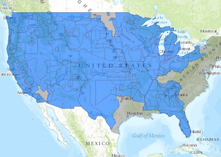
Thank you - I think it’s a more interesting way of showing the frontier and the difficulties of actually holding it over just showing de jure control. My only regret is that I haven’t found a way to accurately depict native polities without also making the map look cluttered. The data is really hard to come by too.Looks very nice, thank you, I can learn from this.
Would EmperorTigerstar's "Loss of Native Lands" work? That's what I used, in combination with OmniAtlas, to create the below:Thank you - I think it’s a more interesting way of showing the frontier and the difficulties of actually holding it over just showing de jure control. My only regret is that I haven’t found a way to accurately depict native polities without also making the map look cluttered. The data is really hard to come by too.
And where is that band who so vauntingly swore
That the havoc of war and the battle's confusion
A home and a country should leave us no more!
Their blood has washed out their foul footsteps' pollutionView attachment 678330Reworked an earlier map of 1790s Canada to create the Hudson Bay drainage basin, hence potential inaccuracies in the Ontario/Manitoba area.
North America on 12 April 1861.
You may check out this map by FancyHat (only if you haven't seen it). I like how he depicted America.Thank you - I think it’s a more interesting way of showing the frontier and the difficulties of actually holding it over just showing de jure control. My only regret is that I haven’t found a way to accurately depict native polities without also making the map look cluttered. The data is really hard to come by too.
Last edited:
Thank you - I think it’s a more interesting way of showing the frontier and the difficulties of actually holding it over just showing de jure control. My only regret is that I haven’t found a way to accurately depict native polities without also making the map look cluttered. The data is really hard to come by too.

Research Guides: Native American Spaces: Cartographic Resources at the Library of Congress: Treaty Boundaries and Cessions
This guide provides access to digitized primary sources, print bibliographies, and related online resources for the study of Indian and Alaska native people of the United States.
Interactive Time-Lapse Map Shows How the U.S. Took More Than 1.5 Billion Acres From Native Americans
This interactive map, produced by University of Georgia historian Claudio Saunt to accompany his new book West of the Revolution: An Uncommon History o ...
www.slate.com
List of American Indian Wars - Wikipedia
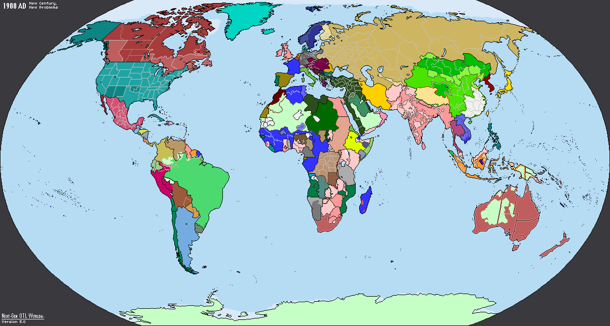
Does anyone has a pre-WW1 world map that includes the maximum number of administrative divisions possible?
In 1900 the Russian Empire, German Empire, etc. contain administrative divisions, whereas in 1914 they do not.
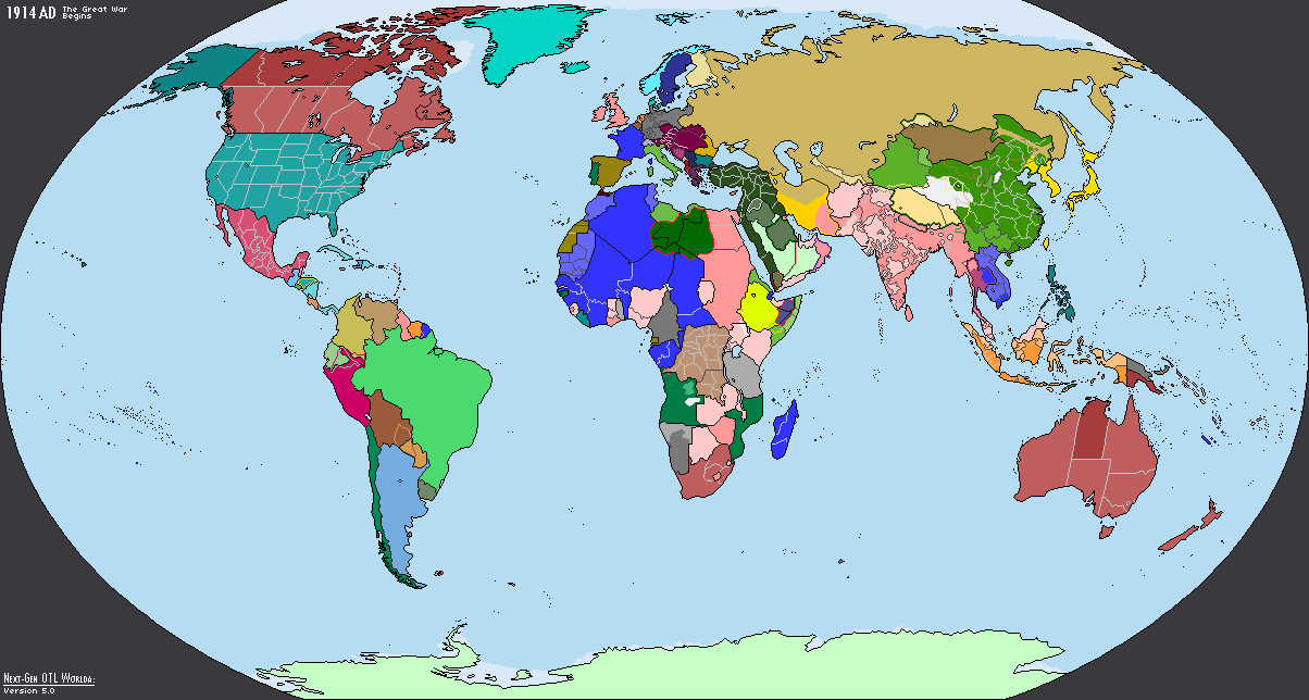
In 1900 the Russian Empire, German Empire, etc. contain administrative divisions, whereas in 1914 they do not.
Well, you can probably just copy the 1900 administrative borders into the 1914 map.Does anyone has a pre-WW1 world map that includes the maximum number of administrative divisions possible?
In 1900 the Russian Empire, German Empire, etc. contain administrative divisions, whereas in 1914 they do not.
This is what I am going to inevitably do, I was just asking to see if there were any pre-existing ones before I start it.Well, you can probably just copy the 1900 administrative borders into the 1914 map.
Not to my knowledge at least, unfortunately.This is what I am going to inevitably do, I was just asking to see if there were any pre-existing ones before I start it.
the last thing this project needs is another redrawing of borders, because what usually ends up happening is that the patch is only applied to some of the maps, thus creating an inconsistency among the maps (which this series was made to prevent from happening)Redid India's states based on the R-QBAM
View attachment 812822
Two things I wanna note:the last thing this project needs is another redrawing of borders, because what usually ends up happening is that the patch is only applied to some of the maps, thus creating an inconsistency among the maps (which this series was made to prevent from happening)
- The 1960-2000 maps have different subdivision borders than the more "recent" ones
- The original borders on the 2010s and 2020s maps were made at least 7-8 years ago, and just like China's internals, they were long-overdue for a redraw
Sacer Bubonicus
Banned
Bit of a weird request: a map of Siberian coal reserves, and/or a map of world coal reserves.
examples:
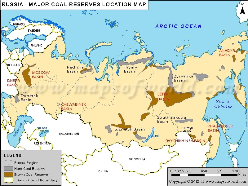
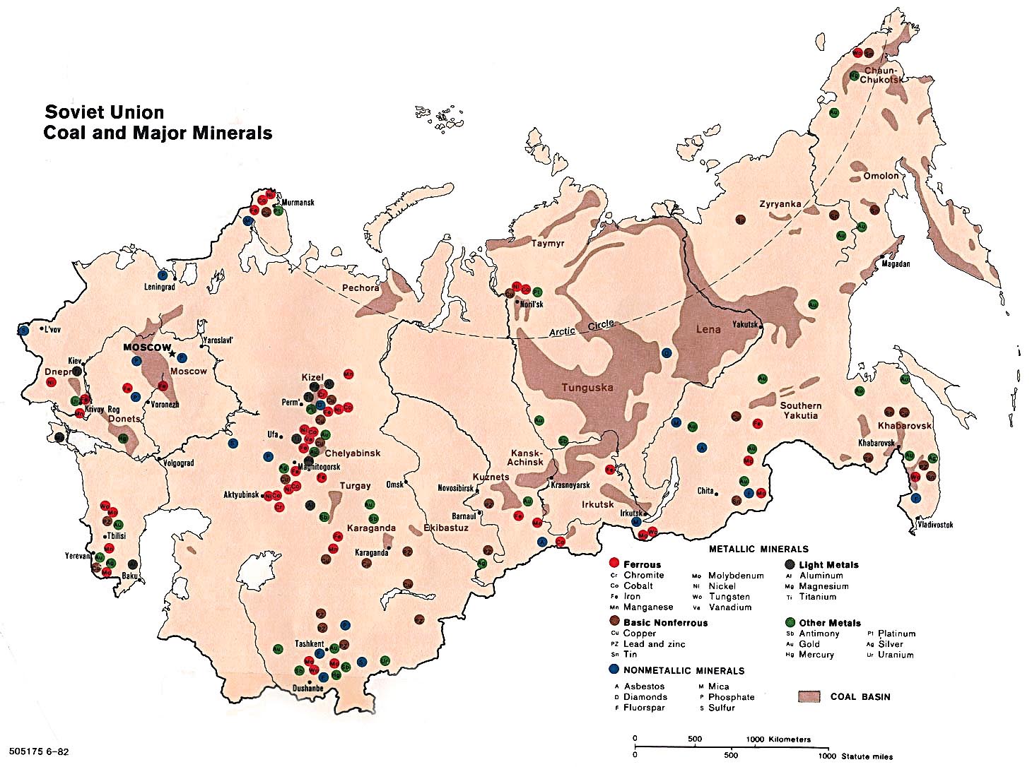
(1) https://images.mapsofworld.com/russia/russia-coal-reserves-map.jpg
(2) https://www.marxists.org/glossary/media/places/u/ussr/1982/coal-minerals.jpg
I think it would be good to add global resource maps to the Worlda series.
examples:
(1) https://images.mapsofworld.com/russia/russia-coal-reserves-map.jpg
(2) https://www.marxists.org/glossary/media/places/u/ussr/1982/coal-minerals.jpg
I think it would be good to add global resource maps to the Worlda series.
After weeks of ceaseless toil, I am pleased to present:
The "Great Overhaul of China*" (Part 1 of 2)
*also Russia, Kazakhstan, Tibet, Mongolia, Korea, etc.
credit for some of this goes to various people who posted useful patches in this thread, particularly Library of Alexandria
Postmodern Era
World Wars
19th Century
Early Modern Era
Late Medieval Era


The "Great Overhaul of China*" (Part 1 of 2)
*also Russia, Kazakhstan, Tibet, Mongolia, Korea, etc.
credit for some of this goes to various people who posted useful patches in this thread, particularly Library of Alexandria
Postmodern Era
World Wars
19th Century
Early Modern Era
Late Medieval Era
Last edited:
Share: