YesLastly, is that icy island up there Iceland or Greenland?
You are using an out of date browser. It may not display this or other websites correctly.
You should upgrade or use an alternative browser.
You should upgrade or use an alternative browser.
Return of Horrible Educational Maps
- Thread starter Westphalian
- Start date
Good things about this globe? Well, they got Africa comparatively accurate depicted.

Accurate compared with what, you ask? Well, compared with the rest of that globe.

(Enlarge thumbnail at your own risk. You have been warned.)
Accurate compared with what, you ask? Well, compared with the rest of that globe.
(Enlarge thumbnail at your own risk. You have been warned.)
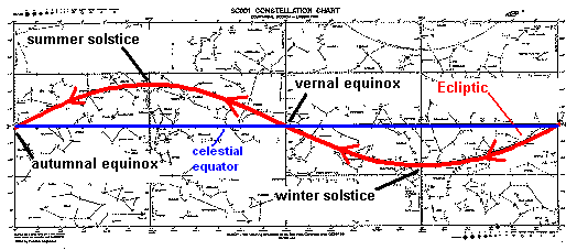
What is that one black-white striped line running over the entire world?Good things about this globe? Well, they got Africa comparatively accurate depicted.
The ecliptic.What is that one black-white striped line running over the entire world?

Ecliptic - Wikipedia
TIL that PNG is part of Australia and NZ is in AntarcticaGood things about this globe? Well, they got Africa comparatively accurate depicted.
View attachment 771467
Accurate compared with what, you ask? Well, compared with the rest of that globe.
View attachment 771468
(Enlarge thumbnail at your own risk. You have been warned.)
This globe is an abomination. I almost think it deserves an award.Good things about this globe? Well, they got Africa comparatively accurate depicted.
View attachment 771467
Accurate compared with what, you ask? Well, compared with the rest of that globe.
View attachment 771468
(Enlarge thumbnail at your own risk. You have been warned.)
I had considered something involving astronomy. However, I rejected it as the rotation of the Earth meant that such things as the Celestial equator would change their position relative to Earth geography. Or am I wrong about that?The ecliptic.
The ecliptic doesn't lie neatly on the celestial equator:I had considered something involving astronomy. However, I rejected it as the rotation of the Earth meant that such things as the Celestial equator would change their position relative to Earth geography. Or am I wrong about that?
But that's in the sky, where the sun is compared to the fixed stars, you can't really make a sensible equivalent on earth.The ecliptic doesn't lie neatly on the celestial equator:
True. What some globes do, rather than plot the ecliptic with an arbitrary longitudinal alignment, is draw what's known as an "analemma" in an otherwise boring area of ocean. That way you can trace the Sun's latitude over the course of the year just as well as on the globe we've been looking at, while the east-west dimension is freed up to clearly show the oscillation in the timing of solar noon due to the ellipticality of the Earth's orbit.But that's in the sky, where the sun is compared to the fixed stars, you can't really make a sensible equivalent on earth.
That was VERY common practice on older globes.... I have one from like 1953 that has the analemma....True. What some globes do, rather than plot the ecliptic with an arbitrary longitudinal alignment, is draw what's known as an "analemma" in an otherwise boring area of ocean. That way you can trace the Sun's latitude over the course of the year just as well as on the globe we've been looking at, while the east-west dimension is freed up to clearly show the oscillation in the timing of solar noon due to the ellipticality of the Earth's orbit.
I don't know what's worse; the Great Missouri Sea, the random breakaway state in Colombia, the dented state of Africa, the lack of Ukraine, the UAR, Doggerland, Big Mexico. In the words of Emperor Tiggerstraw: "Nope/10"View attachment 769714
Originally from r/vexillology.
Here's a Worlda I made of it...
View attachment 769722
This is getting sent back to Hell where it came from.
I'd say even a -1/10.I don't know what's worse; the Great Missouri Sea, the random breakaway state in Colombia, the dented state of Africa, the lack of Ukraine, the UAR, Doggerland, Big Mexico. In the words of Emperor Tiggerstraw: "Nope/10"
This is getting sent back to Hell where it came from.
There are lots of map projections. Mercator, Robinson, Gall-Peters and so on.
But Ishihara was new to me.
View attachment 772078
(looking through the red side of an old 3D spectacle might help)
Some politician in London: "We're concerned about the links which there seem to be between some Catholic families in Glasgow and Irish Nationalists. We call upon the Scots to put some distance between them."
A series of earthquakes happen. Half of Scotland moves off to the north-east, incidentally causing part of Norway to move the same way, raising the mountains there to higher than the Alps.
"No, that's not what I meant!"
Whilst people are distracted with this, Belgium takes the opportunity to steal part of northern France.
Share: