yeah the rivers map definitely needs an updateI'm seeing a discrepancy between the 1848 map and the rivers map
View attachment 752569
You are using an out of date browser. It may not display this or other websites correctly.
You should upgrade or use an alternative browser.
You should upgrade or use an alternative browser.
The NextGen OTL Worlda Series
- Thread starter hadaril
- Start date
It's 4b01So i am using Paint.net for a map i am making, and what font do most of the maps (like this one) use?View attachment 754011
I mean text font. "4b01" doesn't seem to be an option.It's 4b01
It doesn't come preinstalled, you have to download it yourself. I found it here: https://www.dafont.com/04b-03.fontI mean text font. "4b01" doesn't seem to be an option.

The Vatican has the color of the Papal State, so here it's just an additionhi, I've been using Worlda for a long time and noticed that some countries don't have their own colors in NCS. Here is my attempt at making colors for some of these countries:
Jan Mayen wasn't discovered until the next decade, and it was by the Dutch, not the Danes.Europe, in 1600.
Fixed!Jan Mayen wasn't discovered until the next decade, and it was by the Dutch, not the Danes.
Full patches for Russia in 1600, 1700, and 1800 please?Europe, in 1600.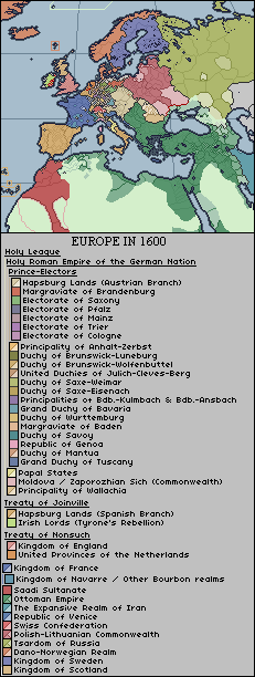
hm, I'm not really sure I could do any of these other than 1800. Before Peter the Great's reforms just barely after 1700, Russian province maps are few and far between, and the ones that do exist are virtually all from the time period and therefore inaccurate.Full patches for Russia in 1600, 1700, and 1800 please?
I mean, you can show the limits of Russia's control in Siberia without any subdivisions.hm, I'm not really sure I could do any of these other than 1800. Before Peter the Great's reforms just barely after 1700, Russian province maps are few and far between, and the ones that do exist are virtually all from the time period and therefore inaccurate.
Would've loved to see subdivisions in this but sources are scarce so eh, nice one
Grand Duchy of Lithuania at its peak, early 15th century:
View attachment 757567
Would've loved to see subdivisions in this but sources are scarce so eh, nice one
... and I made said map in worlda, because of course I did.
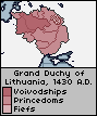
Just for my curiosity, could you superimpose that map of Lithuania with the current borders of Ukraine and Belarus, for comparison?... and I made said map in worlda, because of course I did.
why not do it yourself lol, the modern day maps are available in the first post of the threadJust for my curiosity, could you superimpose that map of Lithuania with the current borders of Ukraine and Belarus, for comparison?
Just for my curiosity, could you superimpose that map of Lithuania with the current borders of Ukraine and Belarus, for comparison?
")
... don't be like that, Entre.why not do it yourself lol, the modern day maps are available in the first post of the thread
Share: