You are using an out of date browser. It may not display this or other websites correctly.
You should upgrade or use an alternative browser.
You should upgrade or use an alternative browser.
The NextGen OTL Worlda Series
- Thread starter hadaril
- Start date
Ironic that a thread about obscure maps would be obscureI found this on an obscure thread, can someone make it into an WorldA?
Oh thank GodView attachment 737605 Here you go.
Are we sure this is actually accurate, though? I ask because there's been several versions of it, some of which were very obviously and visibly inaccurate to the given key. This looks good, but I don't have my atlases handy to check it.
I chose the palette because it was a quick and dirty approximation of the palette of the atlas I was basing the first sections of the map on; it was useful and had good contrast to make it easy to spot where I might have made mistakes. Functional rather than pretty. This looks much better.It was posted on the map thread many moons ago, though I did change the colour palette to something that didn't burn my eyes out. We do need a new one, I should get to work on that sometime after I finish the Europe maps.
Still planning to finish the 1749 map, but really close to the limit of what I can do there without a LOT more research.
Have put it on hold for now, to work on another project instead: I'm creating an improved version of a map -- based on a published AH -- that I originally posted in these forums back in 2014. You can see that earlier version @ https://www.alternatehistory.com/forum/threads/map-thread-xi.275161/page-474#post-8702468 .
Have put it on hold for now, to work on another project instead: I'm creating an improved version of a map -- based on a published AH -- that I originally posted in these forums back in 2014. You can see that earlier version @ https://www.alternatehistory.com/forum/threads/map-thread-xi.275161/page-474#post-8702468 .
Not too sure where this goes but for now this is where I'm posting the sea level rise map. The rise here is 70m, the theoretical maximum - though I did get lazy and copied the sea rise base map for Greenland, Antarctica, and Siberia from Krasnoyarsk Krai and east. Yes, I included Ecuador's 1967 Antarctic claim, though in a different pattern to the others.
Coasts may be inaccurate at places.
EDIT: Fixed the border colour in Georgia and Azerbaijan.
.png")
Also, a blank version of this map:
.png")
Coasts may be inaccurate at places.
EDIT: Fixed the border colour in Georgia and Azerbaijan.
Also, a blank version of this map:
Last edited:
FINALLY!!!Not too sure where this goes but for now this is where I'm posting the sea level rise map. The rise here is 70m, the theoretical maximum - though I did get lazy and copied the sea rise base map for Greenland, Antarctica, and Siberia from Krasnoyarsk Krai and east. Yes, I included Ecuador's 1967 Antarctic claim, though in a different pattern to the others.
Coasts may be inaccurate at places.
View attachment 739627
Also, a blank version of this map:
View attachment 739626
I think you did an amazing job on this, but I could do some small edits to make it more flush.
Thanks. Any improvement to the map is good.FINALLY!!!
I think you did an amazing job on this, but I could do some small edits to make it more flush.
So far I've gotten the MediterraneanThanks. Any improvement to the map is good.
ooh, i'm lovin' this!Not too sure where this goes but for now this is where I'm posting the sea level rise map. The rise here is 70m, the theoretical maximum - though I did get lazy and copied the sea rise base map for Greenland, Antarctica, and Siberia from Krasnoyarsk Krai and east. Yes, I included Ecuador's 1967 Antarctic claim, though in a different pattern to the others.
Coasts may be inaccurate at places.
EDIT: Fixed the border colour in Georgia and Azerbaijan.
View attachment 739636
Also, a blank version of this map:
View attachment 739637
 the Antarctica part in particular would be great for Green Antarctica world maps or for visualizing alternate claims to the continent even when it's still frozen over (as in the respective powers understand that there's land under it and are claiming that and everything above it, so the still-frozen sea is no man's land)
Did you just praise the "lazy" part?the Antarctica part in particular would be great
Last edited:
i may have missed that particular word in my quick read from beforeDid you just praise the "lazy" part?
point is that it's still usefulNuclear Alchemist
Banned
About time. Now I don't have to settle with 100+ meters of polar meltwater.Not too sure where this goes but for now this is where I'm posting the sea level rise map. The rise here is 70m, the theoretical maximum - though I did get lazy and copied the sea rise base map for Greenland, Antarctica, and Siberia from Krasnoyarsk Krai and east. Yes, I included Ecuador's 1967 Antarctic claim, though in a different pattern to the others.
Coasts may be inaccurate at places.
EDIT: Fixed the border colour in Georgia and Azerbaijan.
View attachment 739636
Also, a blank version of this map:
View attachment 739637
it's already called the Champlain SeaUpdated the Gulf Coast, Eastern Seaboard, and what I call "Lake Montreal"
View attachment 741460
Redid this one, last version of this i did was based on a qbam.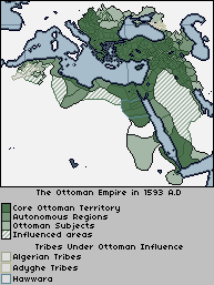
Sorry it's been a while, folks, been busy.
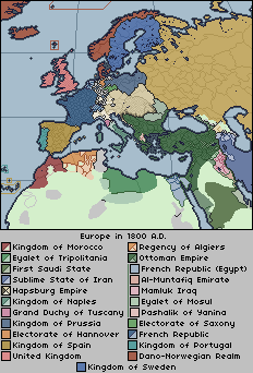
>Blue Iran >Blue Iran >Blue Iran >Blue IranAnd here's the reason I remade this: Europe in 1800.
Bluran Bluran Bluran>Blue Iran >Blue Iran >Blue Iran >Blue Iran
Just a blurBluran Bluran Bluran
Nuclear Alchemist
Banned
Is it possible to do a ~50 meter SLR map? I want to make a map of the worlding the upcoming Beyond Earth mod for HOI4.Not too sure where this goes but for now this is where I'm posting the sea level rise map. The rise here is 70m, the theoretical maximum - though I did get lazy and copied the sea rise base map for Greenland, Antarctica, and Siberia from Krasnoyarsk Krai and east. Yes, I included Ecuador's 1967 Antarctic claim, though in a different pattern to the others.
Coasts may be inaccurate at places.
EDIT: Fixed the border colour in Georgia and Azerbaijan.
View attachment 739636
Also, a blank version of this map:
View attachment 739637
Share: