Aside from all the sticky political considerations, I'm perplexed and intrigued by the internal state borders of TTL's USA. Based on your later post about there being states with high Native American populations, I can make assumptions about some of the more obvious ones, but I can't really tell why a lot of the states are shaped the way they are. I'm assuming a lot of it is due to the use of watershed borders rather than straight lines?
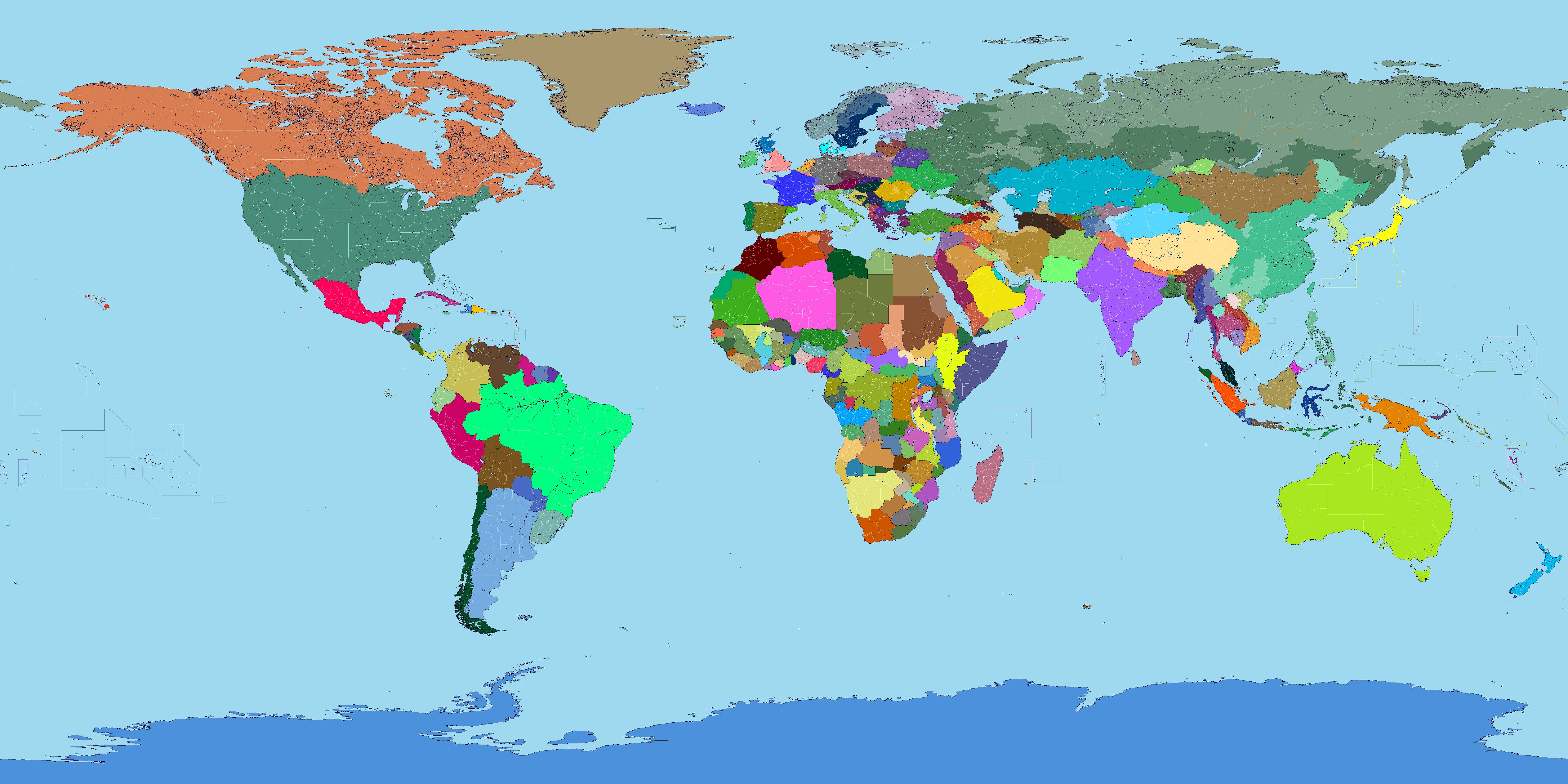
A map of a more perfect world. A labelled version is coming soon. Thoughts? Questions? Feedback?
You are using an out of date browser. It may not display this or other websites correctly.
You should upgrade or use an alternative browser.
You should upgrade or use an alternative browser.
Map Thread XXI
- Thread starter fluttersky
- Start date
-
- Tags
- map map thread
- Status
- Not open for further replies.
Threadmarks
View all 131 threadmarks
Reader mode
Reader mode
Recent threadmarks
[50+ Likes] Sultanate of England, by Sārthākā Big Nations series, by Alex0505 A re-projection of Jean Lattre's 1762 world map, by Ashtagon [50+ Likes] The Russo-Ukrainian conflict in context, by NeonHydroxide Rose, Tulips, and Liberty, by Unkown00 Caliphate of Albion 1450, by Sārthākā 1932 Centauri-Human War, by Alex0505 Bharata is the World (part 3) by wildviper121Emperor-of-New-Zealand
Kicked
I'm aware. I didn't think any of my points warranted going to PolChat considering I was being deliberately vague about things that everyone knows about offhand. If the rule is "don't mention anything bad about America in any forum except Chat" then it should say that.Chat is down at the bottom of the active Forum list.
Political rants go in Chat.I'm aware. I didn't think any of my points warranted going to PolChat considering I was being deliberately vague about things that everyone knows about offhand. If the rule is "don't mention anything bad about America in any forum except Chat" then it should say that.
Pretty much!Aside from all the sticky political considerations, I'm perplexed and intrigued by the internal state borders of TTL's USA. Based on your later post about there being states with high Native American populations, I can make assumptions about some of the more obvious ones, but I can't really tell why a lot of the states are shaped the way they are. I'm assuming a lot of it is due to the use of watershed borders rather than straight lines?
Emperor-of-New-Zealand
Kicked
I don't think the US is fundamentally bad, but I won't say anymore for fear of getting dragged into the bear cave.What does annoy me is the imputation that our current troubles somehow demonstrate the US is inherently bad.
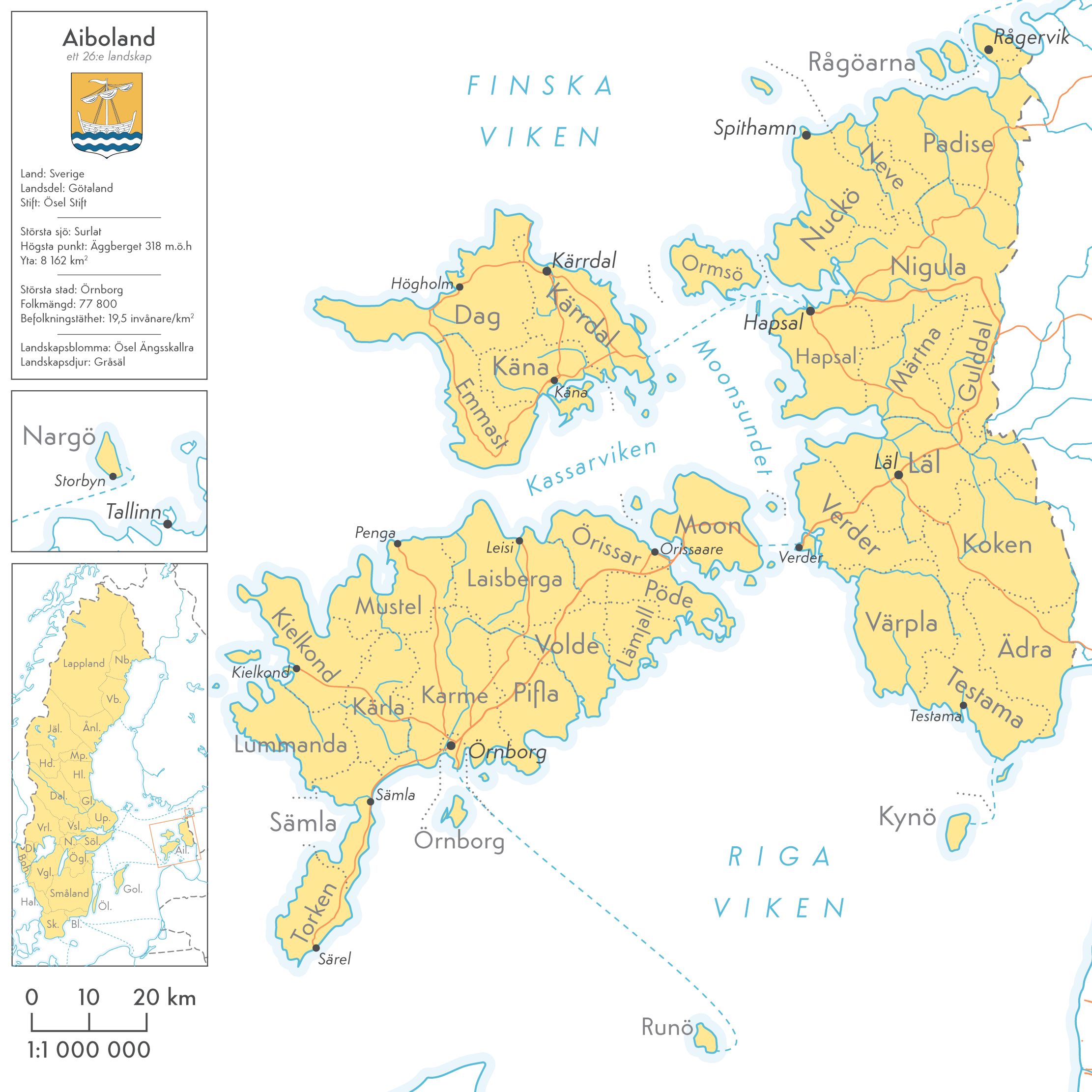
Aiboland (Swedish Estonia), by Cattette

Aiboland - A alternate history Swedish province/landskap based on the historical Swedish settlement of the area.
Historically the Swedish-speaking population of Estonia was rather limited to the Nuckö area, the island of Nargö and the West Estonian archipelago. Most of the Swedish speaking population left for Sweden with the Soviet invasion in 1944. Some regions of Estonia have been largely abandoned and unsettled since the Swedish exodus. Ormsö for instance used to have a pre-war population of 3 000 people. Today 400 people live there. Odensholm had 130; now 2, Nargö had 450; now 35, Rågöarna had 360; now 6.
FireCrispyHistory
Banned
If you want a backstory, click the link in my signature. It is the Blue "The Great War of 2050" under this message. Please let me know how bad my mapping is.
why is it a hexagon mapView attachment 722420With the cockiness of the CSTO armies, CSTO suffered a major defeat in Wellington. The loss of 90% of all CSTO armies was from Wellington alone. The Neutral UN Nations spoke out against the Battle of Wellington, with the Chilean President stating the following. "Wellington has shown us that CSTO is not as strong as we once thought, but also that the NATO armies are cowards." The citizens of Wellington, when they denied soldiers access to their homes, were slaughtered. Officially, by the armies of CSTO, but they barely made it into the suburbs. Nevertheless, the rest of NATO is glad that the tide of the war has changed. They have pushed Cuba to Havana, and Venezuela to Caracas. Catalonia collapses on July 14, during the Sieges of July. CSTO just keeps getting pushed back. However, August and September see NATO focusing more on defense. Like they need to, right? Although, Morocco never sent a single soldier to Wellington. And now is the perfect time for an attack...
If you want a backstory, click the link in my signature. It is the Blue "The Great War of 2050" under this message. Please let me know how bad my mapping is.
FireCrispyHistory
Banned
That was the easiest thing it was for me to do this with. Link to the map: https://mapchart.net/wargames.htmlwhy is it a hexagon map
I am too lazy for paintz.app. Those are the only things I can use, as this is a school chromebook I am using. Plus, I have to limit myself, because they are always watching. GoGuardian sucks. not really, good service, but it still doesn't make me like it more. Im going to stop now.
Last edited:
First important tip: DO NOT state categorically that the map represents "a more perfect world". Word it in a more neutral way, like "what I think a more perfect world would be" or something similar.
A map of a more perfect world. A labelled version is coming soon. Thoughts? Questions? Feedback?
Otherwise, people will be much more likely to judge the map negatively, since it sounds like you are essentially saying that your worldview is the objective truth.
Another comentaries:
Where do I begin? It's too noticeable that this map is "OTL only better, and with the oppressed nationalities we like in America and only those! being free."
Strictly following this logic of balkanizing countries so that all nationalisms have their own country, the United States should be much smaller, not even bigger, since they would have liberated the indigenous nations, Texas and California would be their own States, and Alaska too . Nunavut and Quebec should be independent.
In addition to the fact that there would be a Mapuche nation that covers half of Patagonia and Paraguay should have its borders prior to the War of the Triple Alliance.
That Uruguay will be, at best, the victim of horrible linguistic and ethnic conflicts that will make Quebec look like a joke. Something more similar to Belgium, I would say.
The borders of the Sahara are terrible, I will assume that those of the rest of Africa are based on ethnic lines. I don't know too much about it to comment, but there will definitely be a lot of nations condemned to even greater poverty and misery simply because they don't have easy access to the sea to trade (depending on possibly hostile nations giving them access to the sea). ). Ethiopians are definitely not happy about this.
Ok, the idea of Portugal annexing Galicia is spectacularly bad for a very simple reason: Galicians consider the Portuguese to be poor and wild cousins. This union would have to be directed from Santiago de Compostela and following Galician lines, or else they will never accept it. Basically, this would be equivalent to subordinating 10.3 million people (population of Portugal, OTL 2020 figures) to the wishes and interests of 2.7 million (population of Galicia in OTL 2020) who deeply detest the majority as barbarian savages. . Which, obviously, would not be accepted by the Portuguese either. We would get an apartheid in Europe.
The Basques are definitely not going to like NOTHING not being able to obtain Navarra, it is one of their most essential claims. It would be like trying to have the United States but with the original 13 Colonies being part of the United Kingdom.
Serbia is definitely not going to cede Kosovo to Albania, even if you give them those horrible enclaves in Bosnia in return. This seems more like the UN forced the division of Yugoslavia along ethnic lines rather than the result of a realistic evolution of the situation on the ground.
The Turks are definitely going to be RAGED and probably thinking things like "Why wouldn't we complete the genocide when we could, WHY?!" A very strained relationship with your neighbors is the likely result.
Constantinople won't last long without Greece or Turkey trying to eat it up. The same goes for East Prussia (or Kaliningrad? What exactly is that?), although in that case it will be Poland.
What happened in the Caucasus?!
Russia will not be happy either. China depends on how her situation evolves; it is likely that if they are prosperous and rich, and the neighbors are reasonable, they will not protest too much. Although it is likely that the states that are next to him are the scene of a power game between China and Russia. Koreans will be happy unless they are under the yoke of the Kims.
EDIT: I put the comments before reading the rest of the thread where some points are clarified.
Last edited:

Aiboland - A alternate history Swedish province/landskap based on the historical Swedish settlement of the area.
Historically the Swedish-speaking population of Estonia was rather limited to the Nuckö area, the island of Nargö and the West Estonian archipelago. Most of the Swedish speaking population left for Sweden with the Soviet invasion in 1944. Some regions of Estonia have been largely abandoned and unsettled since the Swedish exodus. Ormsö for instance used to have a pre-war population of 3 000 people. Today 400 people live there. Odensholm had 130; now 2, Nargö had 450; now 35, Rågöarna had 360; now 6.
Wiek was depopulated by Ivan the Terrible under the Livonian War, as Sweden got it afterward it could have a good time for its seeing Swedish settlement especially if it and Dagö and Ormö was made a separate province from Estonia, while Ösel could have seen a greater population replacement in the Swedish conquest from Denmark and ended up joined in the same hypothetical province.
Not to mention some of the non-European ones...[1] With respect to the world as a whole. Not benign at all from the point of view of certain minority groups within, but every European nation has plenty of skeletons of that sort in their closet,
Last edited:
This map is how you get the Yugoslav wars on every continent.
A map of a more perfect world. A labelled version is coming soon. Thoughts? Questions? Feedback?
In face of all the criticism that you are getting.
A map of a more perfect world. A labelled version is coming soon. Thoughts? Questions? Feedback?
Let me give you a voice of support and say I like it.
The well-made map, of course. This is not what most members are worried about.In face of all the criticism that you are getting.
Let me give you a voice of support and say I like it.
The best thing about making a map of a "Perfect World" is not to tell others. 😉
This map of mine is inspired by an ASB web novel about Napoleon. The synopsis goes like this: "Napoleon Bonaparte, who defeated Austria, Prussia, Russia and Britain and became the true ruler of Europe. After the revolution, he stepped down as president, enjoying his retirement in Louisiana. One day, he opened his eyes… and was the Emperor? The story of Napoleon, who woke up in a parallel world just before the Russian campaign." I have only reached chapter 100+ so what happened after 1818 is mostly my speculation.
Although the premise is ASB, the other elements are realistic (me thinks) and well-researched. If you like epic France wanks, I suggest giving this a try. You can read the English version HERE.
Last edited:
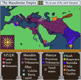
The Macedonian Empire, by CastilloVerde

I'm trying to start making WorldA maps with pixel art, so I thought it's best to start small with this map to get used to it. This took me some hours to do which was longer than I expected. Questions and comments are appreciated!
___________
The POD is that Alexander's close companion Hephaistion avoids his early death. Alexander thus avoids his Achilles-style actions in mourning Hephaistion and lives for many more years.
He abandons India as in OTL (where Chandragupta soon builds an empire there, forging friendly relations with Macedonia in the process) and builds a massive fleet for an Arabian campaign subjugating the coasts and installing pro-Macedonian tributaries there. After some time here, he campaigns in Magna Graecia. The various cities there proclaim him hegemon. He then goes to war with the Samnites, allying with Rome to take revenge on the people who killed his uncle. After some later action in Sicily doing the same, his large fleet sails to Carthage. After some skirmishes, the Carthaginians are intimidated so much they agree to accept Alexander as hegemon. The other Greek and Punic cities in the western Mediterranean eventually follow.
Finally, Alexander sails for the Pillars of Hercules, where he and his army weep, for now, there are no more worlds to conquer.
He spends the rest of his reign with administration and building various cities like the dual capitals of Babylon and Alexandria. By 288 B.C., Alexander dies, having achieved legendary success and is set to be deified during the reign of his adult son and successor. Alexander's long reign begins a melding of Greek and Persian and other cultures. A different Hellenistic era is on the horizon.
Why is the union of the Grand Duchies of Berg and Frankfurt shown as colored different from the rest? Does their having the Ruhr mean they are a bit more independent from, or bought up by, the French?View attachment 722614
This map of mine is inspired by an ASB web novel about Napoleon. The synopsis goes like this: "Napoleon Bonaparte, who defeated Austria, Prussia, Russia and Britain and became the true ruler of Europe. After the revolution, he stepped down as president, enjoying his retirement in Louisiana. One day, he opened his eyes… and was the Emperor? The story of Napoleon, who woke up in a parallel world just before the Russian campaign." I have only reached chapter 100+ so what happened after 1818 is mostly my imagination.
Although the premise is ASB, the other elements are realistic (me thinks) and well-researched. If you like epic French wanks, I suggest giving this a try. You can read the English version HERE.
Threadmarks
View all 131 threadmarks
Reader mode
Reader mode
Recent threadmarks
[50+ Likes] Sultanate of England, by Sārthākā Big Nations series, by Alex0505 A re-projection of Jean Lattre's 1762 world map, by Ashtagon [50+ Likes] The Russo-Ukrainian conflict in context, by NeonHydroxide Rose, Tulips, and Liberty, by Unkown00 Caliphate of Albion 1450, by Sārthākā 1932 Centauri-Human War, by Alex0505 Bharata is the World (part 3) by wildviper121- Status
- Not open for further replies.
Share: