It'd be one of @Qazaq2007's uberbams of the old world. Someone probably has it, given the wiki mentions it, but because the wiki was made with the purpose of never linking back to the main site we don't know where the original map would have been posted.Weird question but does anyone have the first ever completed QBAM? Like the oldest version of it, I was curious to see how far it’s come and I can’t seem to find it on this website (Or anywhere on the internet for that matter, granted I don’t know of any other place you would go for qbam stuff)
You are using an out of date browser. It may not display this or other websites correctly.
You should upgrade or use an alternative browser.
You should upgrade or use an alternative browser.
The Q-BAM Improvement and Core Thread
- Thread starter iori
- Start date
Portions of my 1914 map that I did that have georeferenced borders: Libya (all borders are georeferenced this includes a revised historical French-Libyan border and the borders in Cyrenaica with Jaghbub and etc) and the Urankhai Krai.
Attachments
Crazy Boris
Banned

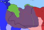
if anyone can alter the coasts on a q-bam base to have the Dutch coast like this?
if anyone can alter the coasts on a q-bam base to have the Dutch coast like this?
How's this?
Is there a 2021 version of the Physical/Topographic layer as well?
Here it is.

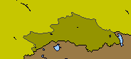
Australia looks pretty off in the current map, especially in South Australia. The eastern border of South Australia should run parallel to the Western Australian border and the border between Queensland and the Northern Territory.
Can anyone help?
I am trying to put together a small run of base-maps with the correct river courses and coastlines;-
This is my WIP of 1AD

My question is, does anyone have any patches for coastline or river changes over the years.
I've done the Caspian and Aral seas, found the patch for the Netherlands and am working on Chinese rivers and coasts.
If not patches, does anyone have any data on areas that have changed [eg Rann of Kutch or the Wash].
I'm not intending to go any further back than 1,000BC so not paeleological changes.
I thank you in anticipation of any patches, maps, links or data you can provide.
So it does not clog up this thread, can you post to my data collection thread;- Historically adjusted Q-BAMs
I am trying to put together a small run of base-maps with the correct river courses and coastlines;-
This is my WIP of 1AD
My question is, does anyone have any patches for coastline or river changes over the years.
I've done the Caspian and Aral seas, found the patch for the Netherlands and am working on Chinese rivers and coasts.
If not patches, does anyone have any data on areas that have changed [eg Rann of Kutch or the Wash].
I'm not intending to go any further back than 1,000BC so not paeleological changes.
I thank you in anticipation of any patches, maps, links or data you can provide.
So it does not clog up this thread, can you post to my data collection thread;- Historically adjusted Q-BAMs
Those Australian subdivisions are outdated, many of our councils have amalgamated or de-amalgamated in the past decade or so. I went through current maps of state/territory councils and made a map of the errors (pink/red line = incorrect border or has de-amalgamated; blue = has amalgamated; orange = couldn't understand the map). This is just a helpful guide for you guys, I don't know how to properly draw maps and don't want to mess with your project. It would be smart to double check this though.Here it is.
As of Nov 23 2021, both Sidama and the South West Ethiopia Peoples' Region are states of ethiopia
FYI the basemap for this is incredibly outdatedCan anyone help?
I am trying to put together a small run of base-maps with the correct river courses and coastlines;-
This is my WIP of 1AD
View attachment 705245
My question is, does anyone have any patches for coastline or river changes over the years.
I've done the Caspian and Aral seas, found the patch for the Netherlands and am working on Chinese rivers and coasts.
If not patches, does anyone have any data on areas that have changed [eg Rann of Kutch or the Wash].
I'm not intending to go any further back than 1,000BC so not paeleological changes.
I thank you in anticipation of any patches, maps, links or data you can provide.
So it does not clog up this thread, can you post to my data collection thread;- Historically adjusted Q-BAMs
Hey Drex, noticed whilst adapting my rivers for this map that some of the coastlines do not match the coastline colour [the biggest example is Eastern Australia].Here it is.
At least 3 different blacks seem to have been used [Borders, Coasts and the outer Frame].
For my own purposes I have re-created them in a single colour & this is for you so you can do the same if you choose [doesn't have to be red];
I have a new thread with base maps Bob Hope's [historically correct coasts and rivers] blank maps that are historically correct.
Coastlines and rivers have been adjusted where needed.
Coastlines and rivers have been adjusted where needed.
I actually think that's a great idea for a Q-BAM map. Especially if we use the ecoregions as defined on One Earth's website as a template. I'd take a more active role in doing that if I knew how to align their exact ecoregions to the Q-Bam map especially due to all of the maps that they use on their site being JPEGs compared to the PNGs used for the Q-BAM map . The most I can do at the moment is provide this link to their general bioregions overview page for more detail into the specific bioregions that could be used in the map due to my lack of knowledge on that front.What do you think about creating a Biome/Ecoregion map. With Ecoregions in the same Biome mapped with similar colours.

Does anyone have the absolute latest QBAM, with all the coastline and Australia patches?
Patch for Russo-Ukrainian War
Early February 26th, 2022 • Start of Kyiv Offensive

*PLEASE PLEASE PLEASE, I know that my claimed territory “dots” are off, I don’t understand quite how to make them. Also, if anyone can tell me an easier way to make occupation stripes than by hand that would be greatly appreciated, much thanks
Early February 26th, 2022 • Start of Kyiv Offensive
*PLEASE PLEASE PLEASE, I know that my claimed territory “dots” are off, I don’t understand quite how to make them. Also, if anyone can tell me an easier way to make occupation stripes than by hand that would be greatly appreciated, much thanks
Share: