You are using an out of date browser. It may not display this or other websites correctly.
You should upgrade or use an alternative browser.
You should upgrade or use an alternative browser.
Proposals and War Aims That Didn't Happen Map Thread
- Thread starter Beedok
- Start date
why do all these UFAR/Eastasia/Chinese Federation/SDC maps all look about the same?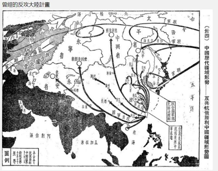
Supposedly this is an authentic and very ambitious Chinese war plans map. Found via Tumblr in the collection of the National Museum for Taiwanese History. If anyone can read traditional Chinese, maybe the notes for the four states/zones of expansion in the former Soviet Union might reveal some interesting details.

That's quite ambitious. Might be fun to use for a "Chiang joins the Axis" scenario.
Supposedly this is an authentic and very ambitious Chinese war plans map. Found via Tumblr in the collection of the National Museum for Taiwanese History. If anyone can read traditional Chinese, maybe the notes for the four states/zones of expansion in the former Soviet Union might reveal some interesting details.
"Quite ambitious" is a huge understatement.That's quite ambitious. Might be fun to use for a "Chiang joins the Axis" scenario.
Someone made a map a while back combining this with other proposals to radically expand China’s borders:
Supposedly this is an authentic and very ambitious Chinese war plans map. Found via Tumblr in the collection of the National Museum for Taiwanese History. If anyone can read traditional Chinese, maybe the notes for the four states/zones of expansion in the former Soviet Union might reveal some interesting details.
All the Chinese "National Humiliation" maps plus the Kuomintang's proposal to annex Siberia and Central Asia combined into one t h i c c China
View attachment 521298
Note: Had to create some provincial borders to make it more equal in size.
been looking for this one, and some of the other proposed "better" states, too--if nothing else, they'll be useful for some of the alternate state names that i'm trying to come up with for my ASB ATL
By the looks of it, this requires US nuking Moscow, after doing some loop-de-loops.
Supposedly this is an authentic and very ambitious Chinese war plans map. Found via Tumblr in the collection of the National Museum for Taiwanese History. If anyone can read traditional Chinese, maybe the notes for the four states/zones of expansion in the former Soviet Union might reveal some interesting details.
Interesting lake around Zambia. Anyone think they can read it? I am guessing it might be some floodplains or lagoons. Or maybe a slightly enlarged lake on the modern border with Congo that is a bit off center, given the age of the map.
Crazy Boris
Banned
I don’t think it would be a single colony, but it might get split between Angola and Mozambique down the middleWould the area in the middle of the Pink Map be administered as a separate colony or would the entire area from Angola to Mozambique be administered as one?
I expect there might be several large tributary states. Then again, the Portuguese suppressed their own centuries long allies in Angola, so maybe not. Probably depends on wheand where the Portuguese find out about the gold and diamonds in the areas, as well as their need for a free (as in unpaid) work force.Would the area in the middle of the Pink Map be administered as a separate colony or would the entire area from Angola to Mozambique be administered as one?
Hard to say, IRL, in the year(s) just before the ultimatum:Would the area in the middle of the Pink Map be administered as a separate colony or would the entire area from Angola to Mozambique be administered as one?
-The parts of central Zambia/Middle Zambezi upstream from mozambique were explored from the town of Zumbo, and more generally to the province of Tete
-The parts of Shonaland/eastern zimbabwe which were occupied at time by portugal (or its ally in the region, the warlord Manuel Antionio de Sousa) were part of a "Province of Manica" (modern Manica and Sofala)
-The parts of western Zambia in Barotseland were explored and contested from Moxico in Angola
I doubt the portuguese would consider any long term recognition of Indirect rule over Matabeleland and Barotseland and they will probably get invaded eventually - like the Gaza empire, which was nominally a vassal since 1885 was invaded a decade later.
Before 1910, control of the interior would be theoretical for the most part, after it...
Attitudes of the first republic favoured *some* level of autonomy (which was never achieved) and decentralisation of the colonies, but that policy was quickly inverted in the 20s, beside the revolution may never happen ITTL
The Eastern part of the Pink map will probably fall under the same concessionary regime as early colonial mozambique, especially since the british would still have interest there and they'd probably dividing part Portuguese africa into largely british owned companies, it isn't hard to imagine central and south eastern Zambia and parts of Malawi (if the british don't enforce some compromise for the scottish missions for the latter) fall under similar companies to the Zambezia company, and the "Province of Manica" (which would probably come to encompass much of Zimbabwe) was also envisioned by the portuguese as a colonial public company. Meanwhile "Barotseland" would be closer to angola and probably in it.
I don't see a third, central african, colony being made until the boom of mining in the copperbelt, which would probably happen later than IRL
I can only speak for my own state, but, while this might have been true in 1973 (and I don't think it really was), it definitely is not today.
Culturally and economically, Jacksonville and the area of what is now Florida north of a line from Jacksonville to the Gulf should be part of "Piedmont". The Tampa/Orlando metro area has more in common with Miami than Jacksonville or Georgia. It could even be argued that the Dade-Broward area could be a separate state (some might even suggest a separate country)
That's the problem with a map like this. People move. Economies change.
Around 1900-1902 the French had to draw a S T R A I G H T L I N E I N T H E D E S E R T between the Saharian territories of Algeria (which were ruled from the civilian gouvernment in Algiers, although the territories themselves were military ruled and still under conquest and barely controlled) and the Colonies of West Africa/French Sudan&Senegal which were ruled from Dakar, of course each administration wanted the most territory


The french in Dakar wanted the red line, The french in Algiers wanted the Black line, a comitee tried to come with a compromise (the green line), eventually they settled a border close to the compromise, and thus the Kel Adagh Tuaregs ended up in Mali, where they've been clashing with the Bamako gouvernment for the last 60 years in 3 revolts which displaced hundreds of thousands
Anyway moving onto other plans, "Une mer au Sahara. Mirages de la colonisation. Algérie et Tunisie (1869-1887)" says that the French considered flooding the Chott Melhrir and the Chott Merouane of Algeria and Tunisia, "The final project, as it was presented in 1883, included a lake of 8000 km2 and 24 m deep, at the location of the Melhrir and Merouane chotts, south of Biskra, connected to the sea by a canal of 240 km, 100 m wide and 10m deep." A french Qattara depression in a way, some argued it would have put additional pressure on Tunisia, but that became moot in 1881 when it was made into a protectorate, eventually the project cost prediction grew tenfold and the project was abandonned

And for last, turning into a plan that make the former seem sane, so back in the 1840s, when it became clear Algerians are, in fact, not french, and that a people you conquer and subdue will actually resist, and before a large settler population which needed a cheap workforce came, the administration and army was split into three way to deal with the "Indigenous question": "L'assimilation", "L'extermination" (see bugeaud or Cavaignac's plan, or the underlying ideology behind the gasing of algeria in the 1840s) and "Le Refoulement" (aka deporting arabs either to Tunisia/morocco or sending them in death marches in the sahara), but within the last two movements there was an... interesting... movement, spearheaded by Eugène Bodichon and Eugène Mathieu Subtil inspired by the Ottoman "Sürgün" (forced displacement of ethnic groups, infamously used during the Armenian genocide) to replace Arab Algerian labour with Subsaharian one
"Many French planners found this policy particularly intriguing (Aucapitaine 1859). In it they saw the chance to cut once and for all the Gordian knot of the indigenous question. It was a simple matter to combine the logic of the Ottoman sürgün with the discourses of extermination and expulsion. Might not the ultimate solution to the problem, they asked, be found the day when they had an Algeria without Algerians?
Some of the various plans involved buying over a hunderd thousand slaves, more than 5,000 a years, from the Trans-saharian trade, who would then be freed and used as auxiliaries in the colonial army, who would then be settled across Algeria, other involved directly using them as slave labour in Algeria.
"Subtil’s 1840 project shows that even as the French state had legally committed itself to ending the trade in African slaves, its highest agents were ready to build an Algerian colony with the labor of people purchased as slaves. More than just tolerating indigenous forms of slavery, in 1840 the French government approved buying slaves, a decision that had it been implemented would have involved the French state directly in the trans-Saharan slave trade and opened the possibility that Algeria might become some sort of slave colony. Rather than a stopgap labor fix, this project hinged upon resolving the indigenous question, a question embedded in the unique condition in Algeria, a settler colony in an already settled land. Its main thrust responded to the sort of ambitious projects military leaders like General Bugeaud envisioned to solve the indigenous question and the security crisis: namely, his military colonies could be built and populated by slaves. "
-Rethinking Abolition in Algeria. Slavery and the "Indigenous Question"
-Apostles of Modernity Saint-Simonians and the Civilizing Mission in Algeria
-Introduction : Un long moment colonial : pour une histoire de l’Algérie au XIXe siècle
The french in Dakar wanted the red line, The french in Algiers wanted the Black line, a comitee tried to come with a compromise (the green line), eventually they settled a border close to the compromise, and thus the Kel Adagh Tuaregs ended up in Mali, where they've been clashing with the Bamako gouvernment for the last 60 years in 3 revolts which displaced hundreds of thousands
Anyway moving onto other plans, "Une mer au Sahara. Mirages de la colonisation. Algérie et Tunisie (1869-1887)" says that the French considered flooding the Chott Melhrir and the Chott Merouane of Algeria and Tunisia, "The final project, as it was presented in 1883, included a lake of 8000 km2 and 24 m deep, at the location of the Melhrir and Merouane chotts, south of Biskra, connected to the sea by a canal of 240 km, 100 m wide and 10m deep." A french Qattara depression in a way, some argued it would have put additional pressure on Tunisia, but that became moot in 1881 when it was made into a protectorate, eventually the project cost prediction grew tenfold and the project was abandonned
And for last, turning into a plan that make the former seem sane, so back in the 1840s, when it became clear Algerians are, in fact, not french, and that a people you conquer and subdue will actually resist, and before a large settler population which needed a cheap workforce came, the administration and army was split into three way to deal with the "Indigenous question": "L'assimilation", "L'extermination" (see bugeaud or Cavaignac's plan, or the underlying ideology behind the gasing of algeria in the 1840s) and "Le Refoulement" (aka deporting arabs either to Tunisia/morocco or sending them in death marches in the sahara), but within the last two movements there was an... interesting... movement, spearheaded by Eugène Bodichon and Eugène Mathieu Subtil inspired by the Ottoman "Sürgün" (forced displacement of ethnic groups, infamously used during the Armenian genocide) to replace Arab Algerian labour with Subsaharian one
"Many French planners found this policy particularly intriguing (Aucapitaine 1859). In it they saw the chance to cut once and for all the Gordian knot of the indigenous question. It was a simple matter to combine the logic of the Ottoman sürgün with the discourses of extermination and expulsion. Might not the ultimate solution to the problem, they asked, be found the day when they had an Algeria without Algerians?
Some of the various plans involved buying over a hunderd thousand slaves, more than 5,000 a years, from the Trans-saharian trade, who would then be freed and used as auxiliaries in the colonial army, who would then be settled across Algeria, other involved directly using them as slave labour in Algeria.
"Subtil’s 1840 project shows that even as the French state had legally committed itself to ending the trade in African slaves, its highest agents were ready to build an Algerian colony with the labor of people purchased as slaves. More than just tolerating indigenous forms of slavery, in 1840 the French government approved buying slaves, a decision that had it been implemented would have involved the French state directly in the trans-Saharan slave trade and opened the possibility that Algeria might become some sort of slave colony. Rather than a stopgap labor fix, this project hinged upon resolving the indigenous question, a question embedded in the unique condition in Algeria, a settler colony in an already settled land. Its main thrust responded to the sort of ambitious projects military leaders like General Bugeaud envisioned to solve the indigenous question and the security crisis: namely, his military colonies could be built and populated by slaves. "
-Rethinking Abolition in Algeria. Slavery and the "Indigenous Question"
-Apostles of Modernity Saint-Simonians and the Civilizing Mission in Algeria
-Introduction : Un long moment colonial : pour une histoire de l’Algérie au XIXe siècle
Last edited:
good day for Africa worldas huhAround 1900-1902 the French had to draw a S T R A I G H T L I N E I N T H E D E S E R T between the Saharian territories of Algeria (which were ruled from the civilian gouvernment in Algiers, although the territories themselves were military ruled and still under conquest and barely controlled) and the Colonies of West Africa/French Sudan&Senegal which were ruled from Dakar, of course each administration wanted the most territory
The frogs in Dakar wanted the red line, The Frogs in Algiers wanted the Black line, a comitee of frogs tried to come with a compromise (the green line), eventually they settled a border close to the compromise, and thus the Kel Adagh Tuaregs ended up in Mali, where they've been clashing with the Bamako gouvernment for the last 60 years in 3 revolts which displaced hundreds of thousands
Anyway moving onto other plans, "Une mer au Sahara. Mirages de la colonisation. Algérie et Tunisie (1869-1887)" says that the French considered flooding the Chott Melhrir and the Chott Merouane of Algeria and Tunisia, "The final project, as it was presented in 1883, included a lake of 8000 km2 and 24 m deep, at the location of the Melhrir and Merouane chotts, south of Biskra, connected to the sea by a canal of 240 km, 100 m wide and 10m deep." A french Qattara depression in a way, some argued it would have put additional pressure on Tunisia, but that became moot in 1881 when it was made into a protectorate, eventually the project cost prediction grew tenfold and the project was abandonned
And for last, turning into a plan that make the former seem sane, so back in the 1840s, when it became clear Algerians are, in fact, not french, and that a people you conquer and subdue will actually resist, and before a large settler population which needed a cheap workforce came, the administration and army was split into three way to deal with the "Indigenous question": "L'assimilation", "L'extermination" (see bugeaud or Cavaignac's plan, or the underlying ideology behind the gasing of algeria in the 1840s) and "Le Refoulement" (aka deporting arabs either to Tunisia/morocco or sending them in death marches in the sahara), but within the last two movements there was an... interesting... movement, spearheaded by Eugène Bodichon and Eugène Mathieu Subtil inspired by the Ottoman "Sürgün" (forced displacement of ethnic groups, infamously used during the Armenian genocide) to replace Arab Algerian labour with Subsaharian one
"Many French planners found this policy particularly intriguing (Aucapitaine 1859). In it they saw the chance to cut once and for all the Gordian knot of the indigenous question. It was a simple matter to combine the logic of the Ottoman sürgün with the discourses of extermination and expulsion. Might not the ultimate solution to the problem, they asked, be found the day when they had an Algeria without Algerians?
Some of the various plans involved buying over a hunderd thousand slaves, more than 5,000 a years, from the Trans-saharian trade, who would then be freed and used as auxiliaries in the colonial army, who would then be settled across Algeria, other involved directly using them as slave labour in Algeria.
"Subtil’s 1840 project shows that even as the French state had legally committed itself to ending the trade in African slaves, its highest agents were ready to build an Algerian colony with the labor of people purchased as slaves. More than just tolerating indigenous forms of slavery, in 1840 the French government approved buying slaves, a decision that had it been implemented would have involved the French state directly in the trans-Saharan slave trade and opened the possibility that Algeria might become some sort of slave colony. Rather than a stopgap labor fix, this project hinged upon resolving the indigenous question, a question embedded in the unique condition in Algeria, a settler colony in an already settled land. Its main thrust responded to the sort of ambitious projects military leaders like General Bugeaud envisioned to solve the indigenous question and the security crisis: namely, his military colonies could be built and populated by slaves. "
-Rethinking Abolition in Algeria. Slavery and the "Indigenous Question"
-Apostles of Modernity Saint-Simonians and the Civilizing Mission in Algeria
-Introduction : Un long moment colonial : pour une histoire de l’Algérie au XIXe siècle
That's Lake Bangweulu in full flood.Interesting lake around Zambia. Anyone think they can read it? I am guessing it might be some floodplains or lagoons. Or maybe a slightly enlarged lake on the modern border with Congo that is a bit off center, given the age of the map.
Deleted member 90949
This particular map involves taking over the Asian parts of Russia, which are relatively sparsely populated and resource rich. It would seem like the logical areas of conquest for the Chinese.why do all these UFAR/Eastasia/Chinese Federation/SDC maps all look about the same?
Share: