Makes sense, though I imagine just the first name and the time period did it for most of us. Though if they are going with a Greek name, I wonder what they call those born to the reigning Emperor. Born in the White or Born in the Rose?I was considering TR, because "megaxylos" means, roughly, "a big piece of wood", or "a big stick".
You are using an out of date browser. It may not display this or other websites correctly.
You should upgrade or use an alternative browser.
You should upgrade or use an alternative browser.
Map Thread XX
- Thread starter Balkanized U.S.A
- Start date
- Status
- Not open for further replies.
I think that they mentioned on Reddit that 1. this may be a result of averaging as pointed out above, and 2. the separatists don't think of themselves as part of Spain, so asking "do you feel attachment to your region of Spain" would get "no, I don't live in a region of Spain" as a response.The fact that Spanish basque country is shown as having the lowest attachment to region is enough to prove this map is BS and should immediately be dismissed
I agree that it's ridiculous that the mapmaker would write "lowest attachment to region" next to the Basque Country and not stop to think "hmm, that doesn't seem right". There are definitely some problems with the survey.
I notice that Catalonia also has a markedly low attachment to region, probably for similar reasons.
Last edited:
I have my doubts about the regions and countries, but the attachment to the European Union does not seem to be controversial. 😂An interesting OTL map, courtesy of u/desfirsit from Reddit: what do Europeans feel most attached to, sorted by sub-national regions - Europe, their country, or their region?
Data sourced from the 2021 European Quality of Government Index, collected and analysed by the University of Guthenberg's Quality of Government Institute.
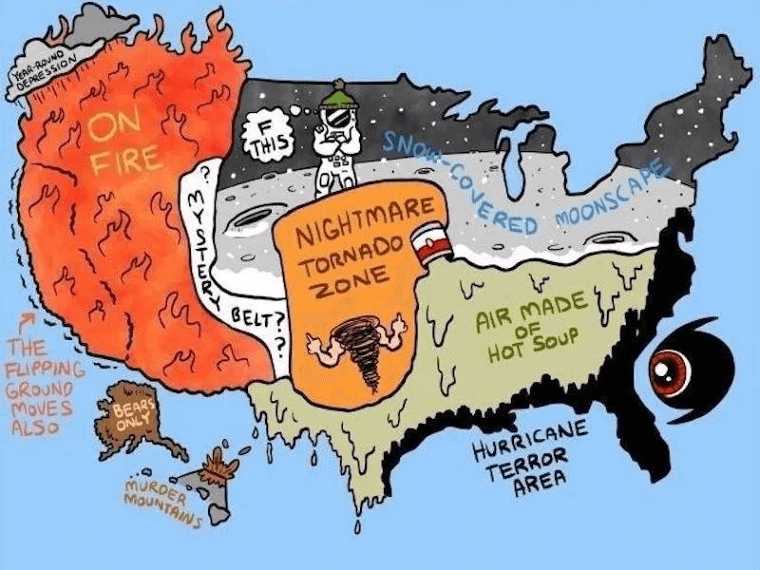
Couple more OTL maps (huh, I think Albuquerque is in the Mystery Belt)
Weather
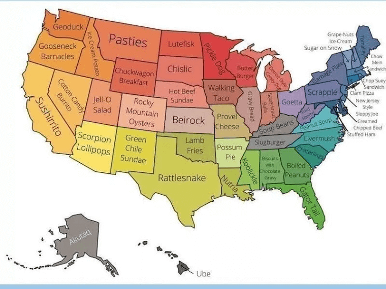
Dubious local foods

 en.wackojaco.com
Weather
Dubious local foods
Your Pet’s Happy Place | WackoJaco
WackoJaco is the place to find all things related to caring for your pets. We share tips and information about adopting, training, and caring for your furry friends
As a Kentuckian, I can't say I've ever heard of "soup beans" before. Weather map is accurate though, especially later into the summer.Couple more OTL maps (huh, I think Albuquerque is in the Mystery Belt)
Weather
Dubious local foods
Your Pet’s Happy Place | WackoJaco
WackoJaco is the place to find all things related to caring for your pets. We share tips and information about adopting, training, and caring for your furry friends
Rattlesnake, possum, squirrel, boiled peanuts, gator, Rocky Mountain oysters, and a chuckwagon breakfast are all goodDubious local foods
Extremely interesting scenario!
But would the geographical changes be enough to alter the general East Asian attitudes towards exploration? Without a significant change in their political and economic conditions, I don't see why they would cross the pacific even if it's considerably easier ITTL...
Malays and Indonesians maybe, but they didn't even make it to Australia until extremely late, or anything east of west papua...
Honestly, I think the biggest game changer will probably be the increased proximity between Polynesia and South America. There is no way you won't get significant intereaction between these cultures ITTL.
Perhaps, perhaps not. I pretty much started with the concept "China and East/Southeast Asia have an easier time colonizing" and went from there. The Polynesians would have a much easier time going to and from the New World, and this would make it more likely for the Malay and eventually the Chinese to hear about it. However, it's also still true that trade winds from China go west, not east.
Map of a federal UK, following the adoption of the Redcliffe-Maud Report, followed by a general shift towards devolution and soon federalism in the late 90s.
States are subdivided into counties (and are largely analogous to OTL regions), have a unicameral elected assembly, and are headed by a Chancellor. Municipalities are largely the same, only are subdivided into Boroughs, and headed by Mayors instead. These Municipalities cover all the major urban areas of the UK, and are similar to OTL metro-mayor areas.
Cornwall is the most recent federal addition, designated as a Municipality despite being largely rural, due to its small size. It was formerly part of Wessex.
Last edited:
You deleted the uploaded file.View attachment 657315
Map of a federal UK, following the adoption of the Redcliffe-Maud Report, followed by a general shift towards devolution and soon federalism in the late 90s.
States are subdivided into counties (and are largely analogous to OTL regions), have a unicameral elected assembly, and are headed by a Chancellor. Municipalities are largely the same, only are subdivided into Boroughs, and headed by Mayors instead. These Municipalities cover all the major urban areas of the UK, and are similar to OTL metro-mayor areas.
Cornwall is the most recent federal addition, designated as a Municipality despite being largely rural, due to its small size. It was formerly part of Wessex.
No plans at the moment, though it is likely that other supplemental materials from the game will be posted in this thread.Ok, this raises many questions. But the only one I'm going to ask is this: any plans to cross post the game on this forum, in it's own thread? (Because the game is being played not on this site, it wouldn't really count as something to go on Shared Worlds)
Yes, he is.Is the emperor Theodore Roosevelt?
This being a reverse mapgame we haven't fully determined the relationship between those two. The Roosevelts ITTL are an international dynasty and sit on the thrones of Britain and Liberia.If it is, I have to wonder on the relationship between the Imperial Family and the Kingdom of New York.
Yes, you got the translation right. ITTL Columbian Emperors have the tradition of taking on a Greek regnal name. Megaxylos is succeeded as Emperor by Atromitos.I was considering TR, because "megaxylos" means, roughly, "a big piece of wood", or "a big stick".
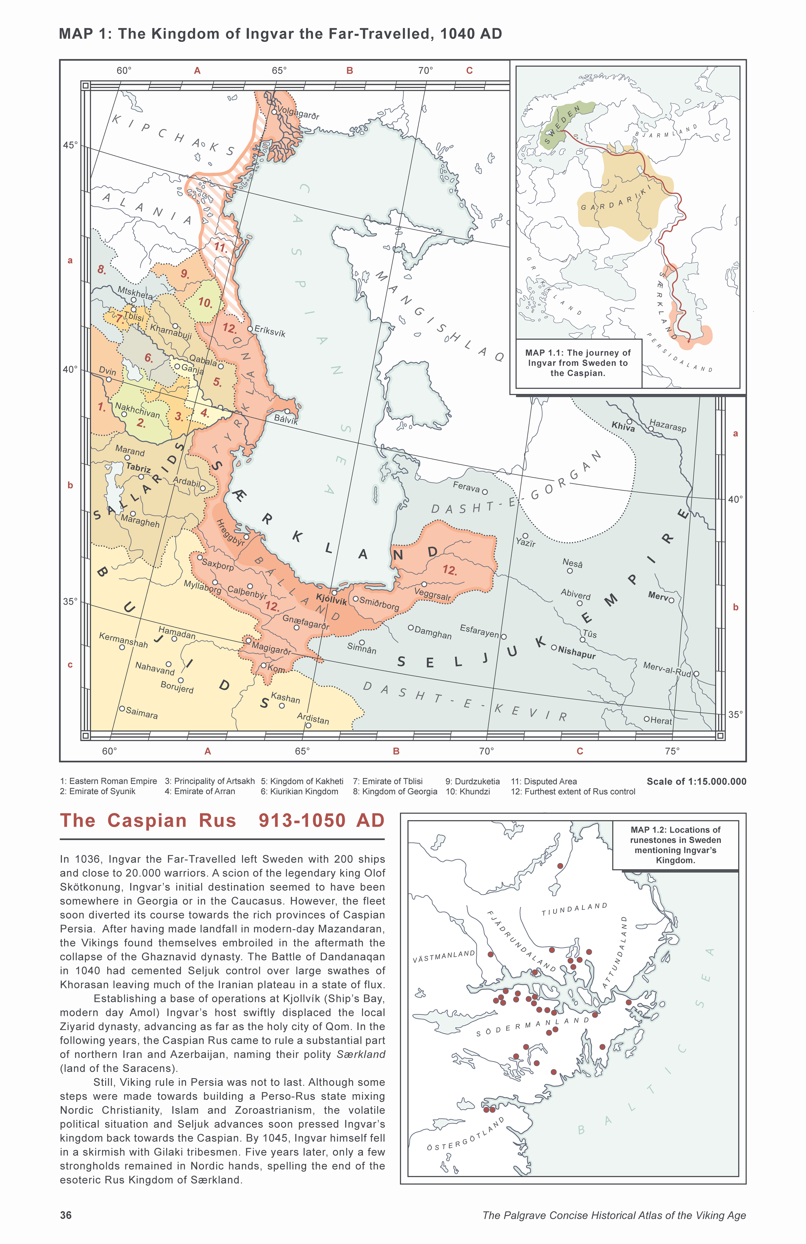
A fun albeit not entirely plausible map which I've been working on for a week or so.
Basically, the map presupposes what could have happened if Ingvar the Far-Travelled was marginally more successful, managing to carve out a shortlived Norse kingdom on the Caspian shore of Medieval Persia.
Excerpt from page 35 of the Palgrave Concise Historical Atlas of the Viking Age
Viking incursions into the Caspian Sea began when 500 Rus long-ships descended the Volga River in 913 AD. After plundering the unprepared coastal regions of Gilan and Mazandaran, the Rus expedition was set upon by Khazar war parties, which slaughtered the Vikings to a man. However, this did little to deter further incursions. Indeed, three decades later, another major raid was launched, which successfully captured the city of Barda’a in modern day Azerbaijan.[1] Although Barda’a was soon abandoned and put to the torch, the city’s capture proved that the Caspian region was ripe for invasion. The flood-gates of conquest were finally thrown completely open when Sviatoslav the Brave, Grand Prince of Kiev, destroyed the Khazar state in 965. With the Volga Delta in friendly hands, the Rus slowly but steadily established a base of operations on the river’s southern estuary, centred on the newly founded city of Volgagard.[2] Small-scale raids grew more frequent and larger in scope in the following decades, culminating with the famous expedition of Ingvar the Far-Travelled in 1036-1040.
The scion of a noble Swedish house related to the legendary King Olof Skötkonnung, Ingvar set out from the Lake Mälaren region with 200 ships and close to 20.000 men in early 1036. Although most historians argue that the original target of Ingvar’s expedition was the Caucasus, it is widely acknowledged that after a few years of raiding up and down the western banks of the Caspian, the riches and the chaotic state of affairs on the Iranian plateau finally convinced Ingvar to launch a concerted attempt at conquering the southern shores of the Caspian. Having secured the cities of Eriksvik (Derbent) and Bálvík (Baku), Ingvar made landfall close to Amol in 1040, which was quickly seized from its weak and inefficient Ziyarid governor and rebranded as Kjóllvík (ship’s bay). Politically speaking, the Viking Invasion occurred at an extremely fortuitous time. The dominant Ghaznavid dynasty had just suffered a crushing defeat at the hands of the invading Seljuk Turks at the Battle of Dandanaqan (near Merv), effectively shattering any chance of a coordinated Muslim counter-attack.
Allying with Zoroastrian remnants in the hills of Mazandaran and Tabarestan (evident in the Rus exonym for the region - Bálland, meaning Land of Bonfires), Ingvar’s men made stunning territorial gains over the course of the next five years. Attempts were made at ironing out some kind of Rus-Persian polity aimed at the permanent establishment of Viking settlements in Særkland (Land of the Saracens), but by then an indigenous reaction had already materialised. Tughril Beg, the leader of the Seljuks was adamantly opposed to the presence of a Christian principality within his claimed domains and soon turned the full might of the Turkoman military machine on the outnumbered Rus. Rebellions soon broke out, galvanised by the Seljuk offensive. It was in the course of fighting one of these insurrections that Ingvar fell in 1045 somewhere in Gilan. After his death, the Rus rallied around a captain named Baggi[3], who withdrew to Kjollvík. However, five years later the last Viking stronghold in Iran fell to one of Tughril’s commanders, who killed or enslaved most of the defenders. As the Gripsholm Runestone in modern-day Sweden sadly laments: “… They travelled valiantly far for gold, and in the east gave food to the eagle. They died in the south in Særkland.”[4]
[1] In OTL, this raid was unsuccessful, partly thanks to the outbreak of dysentery amongst the Vikings.
[2] An ATL city.
[3] The name of an actual ship’s captain in Ingvar’s expedition, mentioned on runestone U778
[4] From the OTL runestone
Notes:
I had a lot of fun coming up with alternate Norse names for Iranian cities. The translations are very literal and absolutely not meant to be taken as an authoritative interpretation of what Ingvar's expedition might have named the following cities.
Bálvík - Baku (Fire Bay, named after the Fire Temple of Baku)
Calþenbýr - Qazvin (Caspian Town, named as the chief city close to the Caspian)
Eríksvík - Derbent (Erik's Bay, named after St. Erik)
Gnæfagarðr - Rayy (Tower City, anachronistically named after the funeral tower of Tughrul Bey)
Hreggbýr - Rasht (Rain Town, named for the wet climate of the city)
Kjóllvík - Amol (Ship's Bay, where Ingvar's fleet landed in ATL)
Magigarðr - Saveh (Magi's City, in Iranian tradition the Three Magi set out from Saveh)
Myllaborg - Abhar (Mill's Castle, named for the agricultural produce)
Saxþorp - Shahin (Sword Settlement, named for the fine blades produced there OTL)
Smiðrborg - Sari (Smith's Castle, named for the city's supposed connection to Kaveh the Blacksmith)
Veggrsalr - Gorgan (Wall Place, named after the Walls of Gorgan)
Sources:
Map 1: Traced from "Die Länder von Islâm zur Zeit der Bujiden 945-1055" in Spruner, Karl & von Menke, Theodor: Hand-Atlas für die Geschichte des Mittelalters und der neueren Zeit (Gotha, 1880) with cross-reference to "Map 14: 1040 to the end of the 11th century: The Seljuks and Qarakhanids" in Bregel, Yuri: An Historical Atlas of Central Asia (Brill, 2005) as well as various maps on wikipedia.
Map 1.1: Generated in QGis by using data from projectlinework (Moriarty Hand) and finished in Adobe Illustrator.
Map 1.2: Traced from a Swedish historical atlas whose name sadly escapes me. Runestone placements from Larsson, Mats G.:"Ingvarstågets arkeologiska bakgrund" (The archaeological background of the "Ingvar expedition") in Forvännen: Journal of Swedish Antiquarian Research (1983): 98-113
Last edited:
waitDubious local foods
who's making fun of gravy bread and butterburgers?
Lutefisk can "ferment" in hell
Deleted member 139407
I've lived in New Jersey my entire life with the only exception being going to college in New York state... I've never even heard of a "New Jersey-style Sloppy Joe" until I looked it up today... a Sloppy Joe, since I've heard of the term, has always been ground beef and marinara sauce on some form of bread whether it be a bun or slices of whatever kind of bread tickled your fancy whereas this Sloppy Joe is some sort of deli meat (be it ham, pastrami, turkey, or what have you), Swiss cheese, coleslaw all between two pieces of rye bread...
Needless to say, I just want to try it just to see what's what...
As a Michiganian expat in Wisconsin, I miss a good chili cheese dog. The butter burger is good too.Couple more OTL maps (huh, I think Albuquerque is in the Mystery Belt)
Weather
Dubious local foods
Your Pet’s Happy Place | WackoJaco
WackoJaco is the place to find all things related to caring for your pets. We share tips and information about adopting, training, and caring for your furry friends
Butterburgers are amazing. Go to Culver's and experience the goodness.wait
who's making fun of gravy bread and butterburgers?
Lutefisk can "ferment" in hell
.
Burgers with even more calories added to them than you thought possible sounds like the most American thing ever.Butterburgers are amazing. Go to Culver's and experience the goodness.
.
definitelyButterburgers are amazing. Go to Culver's and experience the goodness.
.
wait no I'm supposed to hate wisconsin
butter burgers definitely do not taste amazing.
phew, that should hold up the fascade for a couple more months
Oh no no no. It's not because you add butter to the burger. Eww.Burgers with even more calories added to them than you thought possible sounds like the most American thing ever.
Butterburgers are called that because you butter the toasted bun.
.
My second map™
This map started on a project of mine thinking about how New France could have survived (and even thrive) with a POD after 1700. It quickly became pretty dark because of the state needed to survive the Anglo threat.

So New France survives and only loses periphery territory until the 7 years war, where they lose New Orleans and southern Louisiana. There is no American Revolution and the North and South become independent in the 1830s. There's still the French revolution and the monarchy flees to Canada/New France.
This New France/Canada is a deeply catholic society, where the church has a big role in colonization, education and healthcare. Every Canadian (except some natives) are forced to serve at least 3 years in the army and will be conscripted in the event of a war. These are 2 of the 3 pillars of Canadian society, the third being the King, but more recently the Legislative Assembly, or National Assembly has been gaining power over the King. There is a large Native and Metis population in Canada, as the government and church let the natives alone as long as they officially convert (and pay some taxes of course).
The American Republic is a republic based on the Roman Republic, having consuls and a powerful senate. They also are fervently anti-Catholic, making Catholics go to Canada or Columbia. The Columbian Confederation is a religiously tolerant nation compared to Canada and America, even if they are a slave owning stratified society. Mexico meanwhile is doing better than OTL.
There are tensions in this North America, from the now 2 century old conflict between the American Republic/Northern British America and Canada/New France, tension between Columbia, and well, everyone, from Mexico who hate them because of the Texas War and the Conquest of Cuba and America who hates them for being slavers . South America is as unstable as ever, with the Peruvian Kingdom, B I G P A R A G U A Y, Grenada, Argentina and others waiting for each opportunity to weaken their neighbors. The American Continent is a powder keg waiting to explode.
The population of Canada is 21 millions, that of the American Republic 32 millions, that of Columbia 28 millions, including the colonies and that of Mexico 14 millions. The 6 largest economy in the Americas are the American Republic, Columbia, Canada, Mexico, Brazil and Argentina
The flags of major powers at the bottom left can let you guess who the great powers of this world are. I'm currently working on a timeline that is going to be close to this map, so if there are positive reactions I am going to start to post it. Also do NOT try to take a closer look at the Argentinian flag , I beg you.
This map started on a project of mine thinking about how New France could have survived (and even thrive) with a POD after 1700. It quickly became pretty dark because of the state needed to survive the Anglo threat.
So New France survives and only loses periphery territory until the 7 years war, where they lose New Orleans and southern Louisiana. There is no American Revolution and the North and South become independent in the 1830s. There's still the French revolution and the monarchy flees to Canada/New France.
This New France/Canada is a deeply catholic society, where the church has a big role in colonization, education and healthcare. Every Canadian (except some natives) are forced to serve at least 3 years in the army and will be conscripted in the event of a war. These are 2 of the 3 pillars of Canadian society, the third being the King, but more recently the Legislative Assembly, or National Assembly has been gaining power over the King. There is a large Native and Metis population in Canada, as the government and church let the natives alone as long as they officially convert (and pay some taxes of course).
The American Republic is a republic based on the Roman Republic, having consuls and a powerful senate. They also are fervently anti-Catholic, making Catholics go to Canada or Columbia. The Columbian Confederation is a religiously tolerant nation compared to Canada and America, even if they are a slave owning stratified society. Mexico meanwhile is doing better than OTL.
There are tensions in this North America, from the now 2 century old conflict between the American Republic/Northern British America and Canada/New France, tension between Columbia, and well, everyone, from Mexico who hate them because of the Texas War and the Conquest of Cuba and America who hates them for being slavers . South America is as unstable as ever, with the Peruvian Kingdom, B I G P A R A G U A Y, Grenada, Argentina and others waiting for each opportunity to weaken their neighbors. The American Continent is a powder keg waiting to explode.
The population of Canada is 21 millions, that of the American Republic 32 millions, that of Columbia 28 millions, including the colonies and that of Mexico 14 millions. The 6 largest economy in the Americas are the American Republic, Columbia, Canada, Mexico, Brazil and Argentina
The flags of major powers at the bottom left can let you guess who the great powers of this world are. I'm currently working on a timeline that is going to be close to this map, so if there are positive reactions I am going to start to post it. Also do NOT try to take a closer look at the Argentinian flag , I beg you.
- Status
- Not open for further replies.
Share: