You are using an out of date browser. It may not display this or other websites correctly.
You should upgrade or use an alternative browser.
You should upgrade or use an alternative browser.
WIP Map Thread
- Thread starter B-29_Bomber
- Start date
-
- Tags
- work in progress

I have finished Africa and the Middle East, and done a lot of work on Eurasia! Once again, the borders in Portuguese Central Africa are inspired by Malê Rising's, and the borders in the Ottoman Empire are inspired by Moerby08's Federalised Ottoman Empire : https://www.deviantart.com/moerby08/art/Ottoman-Empire-federalised-825806481

And I have now finished the map! It's still here because I haven't added the numbers or notes in yet.I have finished Africa and the Middle East, and done a lot of work on Eurasia! Once again, the borders in Portuguese Central Africa are inspired by Malê Rising's, and the borders in the Ottoman Empire are inspired by Moerby08's Federalised Ottoman Empire : https://www.deviantart.com/moerby08/art/Ottoman-Empire-federalised-825806481
View attachment 649085
A WIP map of Martian colonies circa 2100, in an as yet unnamed future history TL.

The general situation on Earth takes heavy inspiration from futuretimeline.net. All Earth nations are trying their best to make the colonies self-sufficient, and should war break out on Earth (and if it did, by the time it finished there wouldn't be much of an Earth anymore), the colonies have all promised to immediately declare neutrality.
One hemisphere's borders and colours have been finished, with more details to be added later.
This is my first map so feedback would be appreciated!
which colonies belong to who?A WIP map of Martian colonies circa 2100, in an as yet unnamed future history TL. View attachment 649571
The general situation on Earth takes heavy inspiration from futuretimeline.net. All Earth nations are trying their best to make the colonies self-sufficient, and should war break out on Earth (and if it did, by the time it finished there wouldn't be much of an Earth anymore), the colonies have all promised to immediately declare neutrality.
One hemisphere's borders and colours have been finished, with more details to be added later.
This is my first map so feedback would be appreciated!
The two big green ones are composed of African and Arabian refugees in Europe, because there are no longer any spaceworthy states there, the vertical band left of that are European colonies, the vertical band left of that are English-speaking Americans, Portuguese-speaking Americans, and Spanish-speaking Americans, and the vertical band left of that are colonies designated to native Americans and Australians.which colonies belong to who?
Are you filling in the ocean by hand? If so, I can fill it in for you. Good work
The reason I'm only filling in parts of it at a time is because the method I used to make the coastline ends up with a lot of pixel-wide gaps, which I need to fix. Doing it this way is the best way I've found to do that efficiently.Are you filling in the ocean by hand? If so, I can fill it in for you. Good work
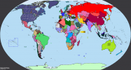
Your map makes me scared of your friends.An ironic and ASB "ideal world" based around the political views of my internet friends.
Need to come up with more ethinic wars and ideas for border-gore
An ironic and ASB "ideal world" based around the political views of my internet friends.
Need to come up with more ethinic wars and ideas for border-gore
Concerning
at least this world is prime-developing ground for tomboys thoYour map makes me scared of your friends.
")
Forget what I said before, This world is a utopia.at least this world is prime-developing ground for tomboys tho
Share: