Proposals and War Aims That Didn't Happen Map Thread

powellmap.jpg


This old classic, Powell's design of the Western arid states done around river basins/drainage basins, to minimize water conflict in the new states. Doubtless would need adjustments to be practical, but the general philosophy is useful, and we may be sorely wishing that Powell got his way in a few decades.

Does anyone have a WorldA of this layingaround? Or if not, would anyone be so kind as to make one?
 
Ooh, I remember that old thing. Tried to map itmyself using other watershed maps, but I didn't get too far. A WorldA or a Q-Bam would be appreciated.
 
powellmap.jpg


This old classic, Powell's design of the Western arid states done around river basins/drainage basins, to minimize water conflict in the new states. Doubtless would need adjustments to be practical, but the general philosophy is useful, and we may be sorely wishing that Powell got his way in a few decades.

Does anyone have a WorldA of this layingaround? Or if not, would anyone be so kind as to make one?
Did he also propose names for the states?
 
powellmap.jpg


This old classic, Powell's design of the Western arid states done around river basins/drainage basins, to minimize water conflict in the new states. Doubtless would need adjustments to be practical, but the general philosophy is useful, and we may be sorely wishing that Powell got his way in a few decades.

Does anyone have a WorldA of this layingaround? Or if not, would anyone be so kind as to make one?
Maybe I'm missing something here, but it doesn't look like anything in this map suggests that these are proposals for states. It's just a map from a USGS report showing "drainage districts." Is the map just to illustrate the concept? And who's this Powell?
 
Did he also propose names for the states?
I would presume that they would just be named for their respective watersheds, though I'm not sure.

Maybe I'm missing something here, but it doesn't look like anything in this map suggests that these are proposals for states. It's just a map from a USGS report showing "drainage districts." Is the map just to illustrate the concept? And who's this Powell?
In the report, Powell sites empirical evidence of rain patterns that contradict the theory that Rain follows the plow, which was widely propagated by politicians, scientists, railroad corporations, and proponents of Manifest destiny.[3][4] Powell also argued against many common practices and laws used to settle unclaimed lands in the Public Domain managed by the General Land Office. Powell discouraged the practice of dividing government land into arbitrary rectangular plots for settlement, arguing that this technique ran the risk of concentrating valuable water resources on single plots, leaving adjacent plots unable to be settled, farmed or used for pasturage.[1] He also pointed out the inadequacies of the Homestead Act of 1860 for settling the arid lands. The Act allowed individuals over the age of 21 to stake a claim for parcel of land of 160 acres.[5] Powell argued that while this was fitting for the humid and sub-humid regions of the country, 160 acres of dry, western land would be too little to support grazing due to sparse vegetation and also too little for agriculture without irrigation due to scarce water availability.[1]

As one of the central tenets of his strategy for developing the western United States, Powell proposed that settlements consist of cooperative communities, similar to those of the Mormons, Pueblos, and Hispanic New Mexicans.[2] This communal lifestyle would allow groups to pool the capital for the irrigation projects necessary to draw water from large rivers. This idea stemmed from the notion that smaller streams can often be diverted by individuals but irrigation projects from larger rivers require more work and capital than individual citizens can provide[1]

He proposed that collectives of 9 or more individuals be able to create their own irrigation or grazing districts with a maximum number of acres per person. The lands would be surveyed and classified primarily by the United States Geological Survey as irrigable lands, timber lands, pasturage lands, mineral lands, and coal lands.[1] These would have different regulations for communal settlement. Individuals and groups would then democratically determine their own allotments and hold other individuals accountable to prevent fraud[2]

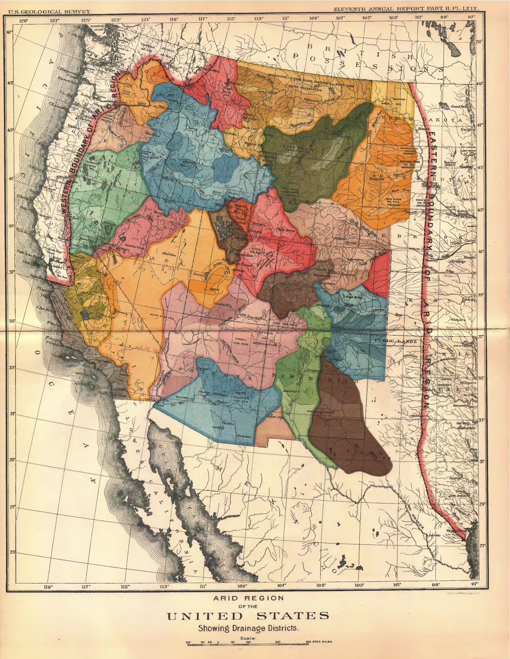
Political borders would be organized based on watershed boundaries, guaranteeing access to irrigation for a maximum number of individuals instead of allowing scarce water resources to be controlled by single allotments. In order to further ensure a democratic division of water, Powell was insistent in the report that water rights not be separated from land they irrigated on the basis that this would prevent developers from monopolizing water rights and extorting landowners.[1]
 
This is more a conspiracy theory* rather than a proposal but I still think that it fits here:

(For context this is Congo by David van Reybrouck, and this section is talking about the post-Mobutu era, right before the Second Congo War started).

It became widely accepted [by Congolese of the] idea that overpopulated Rwanda was longing for raw materials and lebensraum, and therefore had its eyes on Kivu, where so many Tutsis already lived. People believed that Rwanda was out to establish a Grande Republique des Volcanes (Great Volcanic Republic), a new state consisting of Rwanda and Kivu. It did not help any when a group of prominent Rwandans publicly called for a "second Berlin Conference"......

Here is the worlda:

crknmF8.png


Featuring the Great Volcanic Republic in blue and its allies Uganda and Burundi. What remains of the Democratic Republic of the Congo is a puppet state, presumably ruled by James Kabarebe who has gotten has his old job back as well as some more.

*Albeit not a particularly crazy one.
 
Last edited:

Crazy Boris

Banned
2fab72a68f3cc4b5279961564301acdc.jpg

apparently, these are the claims of the Black sovereign citizen movement the Washitaw Nation

From what I can gather from wiki... this is a group of black nationalists that claim to be Moors but also claim to be Moabites but also claim to be a native American tribe that already exists and that believe their “tribe” once ruled over around half of the continental USA and also believe they’re exempt from any state or federal laws?

i feel like this is the political equivalent of wearing a tinfoil hat to stop reptilian space Nazis from reading your mind.
I used to work as a Notary Public in Charlotte NC to pick up a little extra cash, and... we have a rather sizable "Moorish Nation" contingent here.... having read through some of their (somewhat questionable) documents, I'd say yes, your equivalency is very much on point :)
 
Nice of their ancient ancestors to stop at the border of what would one day become Canada.
I'd like to think that this is just the first step of their programme, and they're planning to negotiate with Canada for the rest of the Mississippi watershed further down the line.
 
This isn't quite what the thread title is asking for, but I think this might fit here.

This doesn't fit here at all. It most certainly doesn't belong in a thread about proposals or unfulfilled war aims map thread

Please go and post it in the Fandom AH where it belongs.
 
This doesn't fit here at all. It most certainly doesn't belong in a thread about proposals or unfulfilled war aims map thread

Please go and post it in the Fandom AH where it belongs.

Apologies a weird issue on my phone's part. Sorry.

Thought I fixed it before anyone saw it.
 
Apologies a weird issue on my phone's part. Sorry.

Thought I fixed it before anyone saw it.

Ah! No worries.

And yes, that video seems like it would belong even if it isn't quite what the thread is about. It does give context to the size of countries and in particular gives context to the size of things like Italy's WWII aims in relation to countries we are familar with from the modern day (like how Bolivia more or less seems to encompass what was essentially Italy's European empire during the 1940s). It also gives context to countries that Italy conquered in the lead up to WWII (i.e. Ethiopia)
 
Last edited:
Top