Inspired by B_Munro's
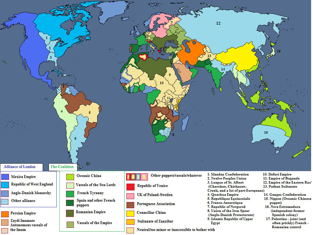
Reign of the Superpowers, I have created another ASB map with a different set of powers. I do not exactly followed the previous creations' profiles but here's the border sources:
- Great Britain from B_Munro's The Reign of George VI, 1900-1925
- Brazil from Isaac Beach and CyberPhoenix001's Brazilwank
- Sultanate of Egypt from Magnysovich's Teutonic Empire
- Sikh Empire from wildviper121's The Sikh Empire (Sarkar-i Khalsa), 1720-1912
- Chinese Tsarat from Comte de Dordogne's The Chinese Tsarat under Romanov rule
- The Netherlands and Dai Viet from B_Munro's Odd Superpowers
Obviously this map is also heavily Code Geass-ish, as you can see from the names. With that said, all of this started when Napoleonic France won the Battle of Trafalgar and successfully invaded the British Isles after that. Subsequent battles drove the British and the Portuguese off their motherlands and to settle down in the New World, though the British had to fight a bitter war to get rid of the US. In Europe, Napoleon started his conquest in Russia, captured Saint Petersburg and pursued the fleeing Romanovs up to the Urals. In the aftermath, European Russia was divided into 3 smaller nations, including a revived Novgorod Republic. The Ottomans would be Napoleon's next target, but before he moved in the Balkan, Mehmed Ali Pasha approached the Emperor and made a deal to divide the Turks' realm together. Meanwhile, the sizable Russian remnants approached the Chinese border at the time the Qing government was busy suppressing the Eight Trigrams Rebellion, and that was the start of the transition from Qing to Jirjak. The influx of Han refugees from the North and the vassalization of Souther China (Later Ming dynasty) bolstered Emperor Minh Mang to enter an alliance with Burma to destroy Siam once and for all. However, after Siam was down, the alliance now had to witness the rise of the Sikhs to the West and an encroaching Dutch Empire-in-Exile to the South.
P/S: I didn't calculate the GDP numbers seriously so please just take it for fun. Also this is the first time I tried out a different water color, it works for most except the French and the Swedish.
 View attachment 635872