It's not much but there were quite a de rivers missing from the old rivers map. The coastlines are circa 1900.
You are using an out of date browser. It may not display this or other websites correctly.
You should upgrade or use an alternative browser.
You should upgrade or use an alternative browser.
I have no knowledge of any other thread, but I'd love it if this could live on.Has there been any progress here, or has the subject moved on to a different thread?
I have no knowledge of any other thread, but I'd love it if this could live on.
Has there been any progress here, or has the subject moved on to a different thread?
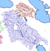
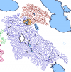
I have wanted to work on this map for a while but I can never find the time, but today's the day. I've amalgamated @Pressedflowers patch and the basin qbam from @endy776, and changed as little as I thought was necessary. Both maps align with one another very well except for the Maritsa and Drin Rivers (I kept the Pressed Flowers patch for the Maritsa and endy's for the Drin)
It's been updated with the most recently patched coastlines, Vardar, Struma, Nestos, and Maritsa rivers, as well as @OxSpace's Nile river patch with a few small edits with the delta region and around lake nasser.
A couple things that I'd like to address:
- I've decided to remove the basins and their territories just to make it easier to work on. They kinda get in the way and I would like to finish the primary part of the map, the rivers, before we do basins. But that's just my approach, and I still would like to have them in when the rest of the rivers get patched cuz it makes them look nice and are good for alternate history maps who might want to use them
- The maritsa river from Pressed Flower's patch doesn't line up with the modern greece/turkey boundary, but I did not touch it because I was not focused on border alignment and I am not sure if that means we need to patch the border or river
-I started working on all of this an hour ago so there's not too much patched at this point, but I'm still interested in patching the rivers and I want to see if anyone else wants to join in
Drex redrew all the rivers in the US and Mexico a while back. I think the patch should be added to this since it looks much more accurate than the current rivers to me.
This is cool, but I think it would be better if we had the borders of the basins too.View attachment 619173
I have wanted to work on this map for a while but I can never find the time, but today's the day. I've amalgamated @Pressedflowers patch and the basin qbam from @endy776, and changed as little as I thought was necessary. Both maps align with one another very well except for the Maritsa and Drin Rivers (I kept the Pressed Flowers patch for the Maritsa and endy's for the Drin)
It's been updated with the most recently patched coastlines, Vardar, Struma, Nestos, and Maritsa rivers, as well as @OxSpace's Nile river patch with a few small edits with the delta region and around lake nasser.
A couple things that I'd like to address:
- I've decided to remove the basins and their territories just to make it easier to work on. They kinda get in the way and I would like to finish the primary part of the map, the rivers, before we do basins. But that's just my approach, and I still would like to have them in when the rest of the rivers get patched cuz it makes them look nice and are good for alternate history maps who might want to use them
- The maritsa river from Pressed Flower's patch doesn't line up with the modern greece/turkey boundary, but I did not touch it because I was not focused on border alignment and I am not sure if that means we need to patch the border or river
-I started working on all of this an hour ago so there's not too much patched at this point, but I'm still interested in patching the rivers and I want to see if anyone else wants to join in
I know, I still want to add them in. They make it look very nice. But I think we should wait until we have the rivers patched, as there will be areas such as in the Balkans that will have rivers look as if they are touching and other such inaccuracies. We can actually make basins for rivers that have other basins or coastlines surrounding them so that they won't get in the way of other ones, like the Rhine and Elbe, but for the Volga and Dnieper we should wait.This is cool, but I think it would be better if we had the borders of the basins too.
I have no control over that though, so do as you feel
Indus River Patch. Added Mangla Dam Lake as well. Lemme know what yall think about the tributary colors bc major rivers end up just being tributaries of other major rivers, such as the Chenab, Ravi, Jhelum, etc.
Dude watershed borders please I beg you
About major rivers being tributaries of tributaries: I had the Platte river in Nebraska have the "major river/tributary" color despite being a tributary of the Missouri.View attachment 622850
Indus River Patch. Added Mangla Dam Lake as well. Lemme know what yall think about the tributary colors bc major rivers end up just being tributaries of other major rivers, such as the Chenab, Ravi, Jhelum, etc.
Quick FixDude watershed borders please I beg you
About major rivers being tributaries of tributaries: I had the Platte river in Nebraska have the "major river/tributary" color despite being a tributary of the Missouri.
Lower danube patch, and basin for the rest of the danube because it's surrounded on all sides. Also decided to do the basins for the rivers I patched a month month ago.
Also, @endy776 I've got an issue with the don-volga river, cuz of a tiny canal. If they're going to be separate basins, do we just wanna ignore it and patch anyway?

View attachment 625778
View attachment 625780
Lower danube patch, and basin for the rest of the danube because it's surrounded on all sides. Also decided to do the basins for the rivers I patched a month month ago.
Also, @endy776 I've got an issue with the don-volga river, cuz of a tiny canal. If they're going to be separate basins, do we just wanna ignore it and patch anyway
I think we can just use drex's colorscheme color for rivers for all the canals, thereby canals can be easily spotted by people looking at the map.
Also I feel like you should make a couple more rivers be "Major tributaries" cause rn you have too many small and big rivers as one color. Maybe make the rivers that exist on the "wikipedia map" that Wendell sent be major tributaries.
Otherwise...
HOLY SHIT THIS IS EPIC THIS IS WHAT I FUCKING DREAMED OF WHEN I STARTED THIS PROJECT
This good? Added a few extra ones in.
List as many changes as u feel r needed, I can fix them pretty quickly.
Yes, this is epic.View attachment 627031
This good? Added a few extra ones in.
List as many changes as u feel r needed, I can fix them pretty quickly.
A small update for the Orontes River, Al Nahral Kabir, Litani River, and the Jordan-Dead Sea river basin.
Didn't know lake Van was an endorheic basin. Otherwise cool map!Mesopotamia, Kura River, and the Van Lake
(Why are you this allergic to borders?
Share: