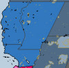
Page 9 of the Statecraft on the Eve of the Civil War:
View attachment 568680
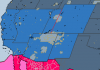
And for those interested here is a link for that article with more maps. Kind of a pity from a map mapmaking perspective we didn't get Colorado (OTL southern California) and Jefferson (OTL Colorado):


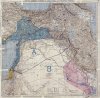
 ), but instead resettled with Cossacks and ethnic Russians, to form a permanent buffer between the Russian Empire and the "rump" Turkish state... sort of like the "Polish Border Strip" that Ludendorff et al were insisting upon in the old Congress Poland. Would sort of blow a hole in the "Wilsonian Armenia" concept...