For the case of Halifax and Dartmouth, their geography on their own looks rather similar to those of New York, New York and Sydney, Australia. All waterways of those three cases lead directly to oceans. So if the intention was to grow Halifax and Dartmouth bigger, there would not be shortage of experience in city management and development.Anyway, in Ontario, Hamilton, London and Windsor could have been bigger, and Halifax didn't grow as much as it possibly could have either. Two of those cities are separated from another reasonably large city by a narrow body of water -- Halifax and Dartmouth, and Hamilton and Burlington -- so there are possibilities to add those. Windsor and Detroit are also separated by a narrow body of water.
You are using an out of date browser. It may not display this or other websites correctly.
You should upgrade or use an alternative browser.
You should upgrade or use an alternative browser.
Cities that could have been much larger
- Thread starter Centralen
- Start date
-
- Tags
- cities urban urban development
- Status
- Not open for further replies.
In 1949, Beijing had a population of about 2 million, and Nanjing had a population of about 2.5 million. By 2010, Beijing's population had grown to about 20 million, but Nanjing's had only grown to 8 million.
Presumably, if the KMT had defeated the communists, Nanjing would have remained the capital, and would have experienced the growth Beijing did in OTL. Other cities on the Yangtze would benefit from this growth and would also be larger.
Presumably, if the KMT had defeated the communists, Nanjing would have remained the capital, and would have experienced the growth Beijing did in OTL. Other cities on the Yangtze would benefit from this growth and would also be larger.
Would you mind share some ideas how to make those cities bigger? A solution would be to provide a convenient and economical way to facilitate trade that is decentralized at its nature. Do merchandise need to be loaded collectively much like rail freight transport?It crossed my mind, too, but IDK how practical that is. The ice isn't quite Arctic, but it's going to be pretty thick.
I'd share ideas if I had anything beyond barge rather than rail. The main products will be potash & grain. Grain will mainly ship before the rivers freeze, I think, but potash needs to go out all year, & that means you need a way to deal with ice. I can't imagine icebreaking along the entire length of a river is practical, tho.Would you mind share some ideas how to make those cities bigger? A solution would be to provide a convenient and economical way to facilitate trade that is decentralized at its nature. Do merchandise need to be loaded collectively much like rail freight transport?
If you could turn, say, Saskatoon into a river transport hub, you could reasonably build grain elevators enough to keep barges filled for the shipping season, I think. I know nothing about storage of potash, so...
It occurs to me moving cattle out this way might work, too, so beef & dairy by barge.
Does the product need to be centrally loaded? I think that's the most reasonable approach, rather than pickup of grain or cattle, say, at individual elevator stops, like it is now. It does raise the question of who pays: do farmers still have to contract for the barges, & get them "as available" (like for railcars), or do they just pay a fee to the elevator operator, or what?
Finding a place on the riverbank suitable for a dock might be problematic, but I have to think someplace could just be dug out.
Prague, Vienna, Budapest and Trieste (among other cities) probably would've been larger and wealthier than OTL had Austria-Hungary survived.
A surviving USSR wouldn't have experienced the demographic disasters. Moscow would be smaller than IOTL as the Party would continue to restrict internal migration. Other cities, especially the industrial hubs, would still be thriving today.
Or, maybe not. Many industrials cities in the PRC went into decline after the market reforms and privatization of the 1990s and 2000s, so a reformed USSR could face a similar problem.
Or, maybe not. Many industrials cities in the PRC went into decline after the market reforms and privatization of the 1990s and 2000s, so a reformed USSR could face a similar problem.
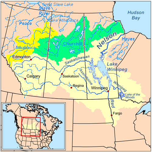
By geography the Saskatchewan River ends drains to the Lakes in Manitoba and then they drains to the Nelson River and eventually to the Hudson Bay.If you could turn, say, Saskatoon into a river transport hub, you could reasonably build grain elevators enough to keep barges filled for the shipping season, I think. I know nothing about storage of potash, so...
Using google map, from a random community in the south inside the city of Winnipeg to a river outlet into Lake Winnipeg, the distance is about 61km. Mapping the distance in Toronto from the CN Tower, the same direct distance covers all the way to a southern tip on the coast of Lake Simcoe. Therefore, if the river transport travels on the Saskatchewan river to a dock on that river outlet, the city of Winnipeg would need to be expand in organization to the extent of the Greater Toronto Area and its neighboring communities. It is a good wish...
They were operating in the past. Its presence in TB means grains were transported by rail to the city, load into the elevator and unload onto ships that traveled on the Great Lakes. However, that industry was much of the pastThunder Bay grain elevator advocates invite residents to celebrate 'Grain Days' CBC News · Posted: Jun 09, 2017 4:01 PM ET | Last Updated: June 9, 2017
worked at 7a car shed and annex in the mid 70's.
From Lake Winnipeg through Lake of the Woods to Thunder Bay, I'd say. (Thunder Bay didn't actually exist, yet, AFAIR.) I don't think Winnipeg would necessarily get larger (or not much). And would it need a canal from the Winnipeg River to Lake of the Woods?drains to the Lakes in Manitoba ...
the city of Winnipeg would need to be expand in organization to the extent of the Greater Toronto Area
 (Not a huge drawback.)
If this happens, you may need bulk Lakes freighters a lot sooner, & that means something like Edmund Fitzgerald sooner (& probably something akin the OTL accident a lot sooner). That also means a need for the St Lawrence Seaway a lot sooner (something that should have crossed my mind before now
).I should also confess I didn't look at the geography.
I presumed shipping out of Churchill, TBH; going south makes more sense.In essence, I also confess that there are two directions from Winnipeg, northeast by rail or lakes, canal plus river to Churchill, MB and southeast by canal and lakes, eventually to the Great Lakes and the St. Lawrence waterway. From Churchill, shipment to northeastern Asia and northern Europe would be shorter.From Lake Winnipeg through Lake of the Woods to Thunder Bay, I'd say. (Thunder Bay didn't actually exist, yet, AFAIR.) I don't think Winnipeg would necessarily get larger (or not much). And would it need a canal from the Winnipeg River to Lake of the Woods?
Main trade (export plus import) partners (total =200%) : USA 128.4%, EU 19.1%, China 16.2%, Japan 5.1%, Mexico 7.7%, Others 23.5%.
Within the EU, ports in northern Europe would benefit from Churchill, MB. Given its under-use port facility, could the port of Churchill, MB be transformed into handling specific cargos to specific locations? Plus, maybe there is no need for maritime shipment service to communities and cities in NWT, Yukon and Nunavut, but maybe Churchill, MB become the distribution hub for those subarctic and arctic areas due to proximity?
I'd say expanding the cities in the south in the Q-W Corridor that are part of the Great Lakes Megalopolis.
On the other hand, if maritime trade was paramount, why no town -- not even a ghost town -- was founded at the Saskatchewan River Forks, which is now a camping site.
🏕⛺🏕⛺🏕⛺🏕⛺. That dock facilities of that town could have shipped stuff upstream to Prince Albert, Edmonton, Calgary and Saskatoon and downstream to Winnipeg.
Last edited:
Shipping from Churchill only confers a marginal advantage on distance to many large ports at the cost of having to deal with the Arctic sea ice.In essence, I also confess that there are two directions from Winnipeg, northeast by rail or lakes, canal plus river to Churchill, MB and southeast by canal and lakes, eventually to the Great Lakes and the St. Lawrence waterway. From Churchill, shipment to northeastern Asia and northern Europe would be shorter.
It looks there were a few fur trading outposts nearby but otherwise nothing. I'm assuming it suffers the same problem as Cairo, IL in that the site is horribly vulnerable to flooding even by the standards of the region. Prince Albert to the west basically fulfills the role as the major city of that area. Speaking of Prince Albert, seems like it could've more or less replaced Saskatoon as the regional center in Saskatchewan.On the other hand, if maritime trade was paramount, why no town -- not even a ghost town -- was founded at the Saskatchewan River Forks, which is now a camping site.
It has two big drawbacks. Permafrost limits the usefulness of the rail line to/from it, & ice on Hudson Bay limits shipping out of it.Given its under-use port facility, could the port of Churchill, MB be transformed into handling specific cargos to specific locations? Plus, maybe there is no need for maritime shipment service to communities and cities in NWT, Yukon and Nunavut, but maybe Churchill, MB become the distribution hub for those subarctic and arctic areas due to proximity?
That I can't answer. Even without heavy river traffic, it would seem to be a good location.if maritime trade was paramount, why no town -- not even a ghost town -- was founded at the Saskatchewan River Forks
I suspect it has to do with when the Prairies were settled. The railway was already built well beforehand, so river traffic in was less important.
If flooding was a concern, could the site be dammed for hydroelectricity and allow small ship voyage miscellaneously. Then the electricity supplies Prince Albert. For the record, the direct distance from Prince Albert to Saskatchewan River Forks is about 45km.It looks there were a few fur trading outposts nearby but otherwise nothing. I'm assuming [Saskatchewan River Forks] suffers the same problem as Cairo, IL in that the site is horribly vulnerable to flooding even by the standards of the region. Prince Albert to the west basically fulfills the role as the major city of that area. Speaking of Prince Albert, seems like it could've more or less replaced Saskatoon as the regional center in Saskatchewan.
Also for the record, Khartoum the Sudanese national capital is located at the confluence of the White Nile, flowing north from Lake Victoria, and the Blue Nile, flowing west from Lake Tana in Ethiopia.I suspect it has to do with when the Prairies were settled. The railway was already built well beforehand, so river traffic in was less important.
Last edited:
I somehow missed this...Speaking of Prince Albert, seems like it could've more or less replaced Saskatoon as the regional center in Saskatchewan.
P.A.'s too far north. The railway OTL ran through Regina, though the original planned route came through here, Edmonton, & Jasper (Yellowhead Pass). It took years to even get Saskatoon on a spur line.
Speaking of Prince Albert, seems like it could've more or less replaced Saskatoon as the regional center in Saskatchewan.
So maybe an alternative history was relocating Prince Albert at the Fork and see if the relocation managed river traffic on the rivers well from Winnipeg to and from Calgary and Edmonton. Call the new location SRF. Would that SRF town be more at the centre of the province while looking at its map. I concur with what happened when the settlement took place.P.A.'s too far north. The railway OTL ran through Regina, though the original planned route came through here, Edmonton, & Jasper (Yellowhead Pass). It took years to even get Saskatoon on a spur line.
But.... if P.A.'s too far north, SRF is located on more or less that longitude. That means SRF would also be too far north for railway network to function for transportation. Could river traffic compensate for the loss in transport, not to mention maritime transport could be decentralized.... if a collection or uniin of business companies own a few ships, they could start shipment and not wait for cooperation from rail services.Saskatchewan Topography
Last edited:
For SRF to be built, IMO, you have to push river transport before rail, & there's really not much demand unless the HBC &/or NWC are bigger. You might get it as a product of a spur north, given the planned rail route runs as planned, which also means Regina probably isn't built (or is tiny); that also likely means Calgary is a bit smaller, since it starts with a spur south, & both Prince George & Prince Rupert are bigger.So maybe an alternative history was relocating Prince Albert at the Fork and see if the relocation managed river traffic on the rivers well from Winnipeg to and from Calgary and Edmonton. Call the new location SRF. Would that SRF town be more at the centre of the province while looking at its map. I concur with what happened when the settlement took place.
What might affect it all is a greater Canadian push for population expansion in the Prairies. Why that happens, I can only guess. If you could manage a gold rush in Manitoba or Western Ontario, it would help (& there is gold there).
I really do wonder why P.A. wasn't built at the forks to begin with. I can't figure the rapids at (near?) P.A. made the site more attractive.
Well, just in case my wording is straightforward, please tell me so my words are going to be appealing.
I in its essence agree with your assessment. As the fork is about 50km east of P.A., maybe a dam allowing river traffic could be built for hydroelectricity which supplies P.A.
In the future though, the map above shows that Edmonton, Calgary, Saskatoon, Winnipeg are connected by rivers. Then a
I confess IDK.
I in its essence agree with your assessment. As the fork is about 50km east of P.A., maybe a dam allowing river traffic could be built for hydroelectricity which supplies P.A.
In the future though, the map above shows that Edmonton, Calgary, Saskatoon, Winnipeg are connected by rivers. Then a
For example a ship from Edmonton goes to P.A., then into Lake Winnipeg, upstream to Winnipeg for rest, then upstream thru the Winnipeg River to the Lake of the Woods, then upstream thru Rainy River to Rainy Lake. Then how to connect from Rainy Lake to Lake Superior? Maybe a canal. Also all the rivers east of the City of Winnipeg may need to be widened....From Lake Winnipeg through Lake of the Woods to Thunder Bay, I'd say. (Thunder Bay didn't actually exist, yet, AFAIR.) I don't think Winnipeg would necessarily get larger (or not much). And would it need a canal from the Winnipeg River to Lake of the Woods?
I confess IDK.Another towns (cities) that could have been larger would be turning canoeing routes to river traffic... but is it worth it? In an alternative story, from Montreal, Quebec, canoeing was possible upstream and westward the Ottawa River--- essentially bypassing St. Lawrence ---and arriving at the capital city for rest, then going into Mattawa and the Mattawa River, then to North Bay on the shores of Lake Nipissing, then French River to the Georgian Bay. Near the Provincial Park was the ghost town. FWIW, the ghost town appears on some earlier Google map if my memory is right but it is no longer on. Maybe the marker is changed to the lighthouse... I confess IDK.
Much of the town site was disassembled shortly after that. A few ruins and the lighthouse still remain.
The rationale that comes to mind for me is defense. Perhaps if you have a more militaristic and anti-British United States there might be a push to try to settle the prairies and develop them in order to resist American attempts to seize them and to secure supply lines between eastern and western Canada. It would be similar to many other attempts to settle frontiers with hostile powers to provide some organic defense capability.What might affect it all is a greater Canadian push for population expansion in the Prairies. Why that happens, I can only guess. If you could manage a gold rush in Manitoba or Western Ontario, it would help (& there is gold there).
No, I'm saying bypass the City of Winnipeg, because that's a dead end. The goal is the Atlantic, via Great Lakes, so you leave Lake Winnipeg for LotWoods, from there to what's now Thunder Bay, & from there by Lakes freighter to wherever. It looks like there's a water connection from LotW to LWinnipeg, so no canal needed. Size of barge on Winnipeg R & Rainy R (from LotW to Superior) may be a limit.Well, just in case my wording is straightforward, please tell me so my words are going to be appealing.
I in its essence agree with your assessment. As the fork is about 50km east of P.A., maybe a dam allowing river traffic could be built for hydroelectricity which supplies P.A.
In the future though, the map above shows that Edmonton, Calgary, Saskatoon, Winnipeg are connected by rivers. Then a
For example a ship from Edmonton goes to P.A., then into Lake Winnipeg, upstream to Winnipeg for rest, then upstream thru the Winnipeg River to the Lake of the Woods, then upstream thru Rainy River to Rainy Lake. Then how to connect from Rainy Lake to Lake Superior? Maybe a canal. Also all the rivers east of the City of Winnipeg may need to be widened....
This covers all the Prairies, more/less, & even south into Minnesota (by Red River to Winnipeg, then north to the lake).
Winnipeg might be a staging point for barges or tugs, I'll agree, but not an ultimate end point; that's much more likely to be OTL Thunder Bay, maybe Banff & Jasper at the other end (which would hurt the National Parks...if they still happen).
That crossed my mind, too. Which seems to want a Black Hills Gold Rush sooner than OTL; otherwise, there's not big U.S. population pressure. The Cherry Creek Rush is a bit far south, but it might do the trick. If it does, you've created Canada sooner, IMO, because desire for population expansion probably means a rail line demand sooner, & that was BC's condition to join--if fear of the U.S. doesn't drive building the railway & creating *Canada no matter what BC wants.The rationale that comes to mind for me is defense. Perhaps if you have a more militaristic and anti-British United States there might be a push to try to settle the prairies and develop them in order to resist American attempts to seize them and to secure supply lines between eastern and western Canada. It would be similar to many other attempts to settle frontiers with hostile powers to provide some organic defense capability.
More U.S. "intrusion" still has to overcome the ice for river transport to be a Thing. I hate to be a party pooper about that, but I'm not seeing any way around it.
If you're prepared to go back farther, you could make the Prairies & BC a part of Canada with a purchase from HBC any time after about 1817, provided HMG would sign off. With a bit more attention on the HBC freight canoes, & the idea of steam propulsion... And, unfortunately, you hit ice as sure as Titanic.
Sorry, folks.
- Status
- Not open for further replies.
Share: