Map Thread XIX

Status
Not open for further replies.
dduzxi2-fb89a32c-f662-4777-a01c-6df910754beb.png

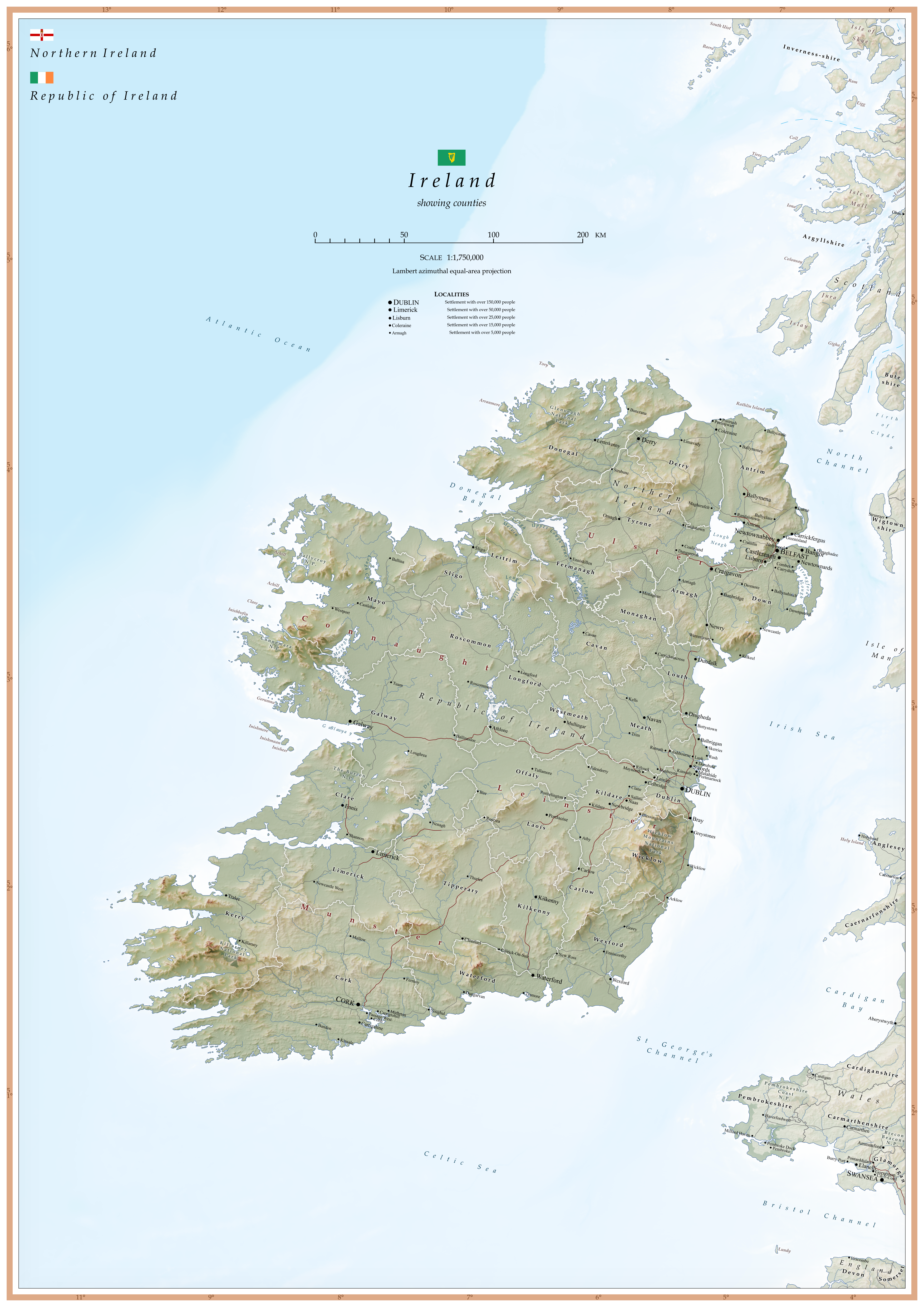
Another map from OTL! Same projection and scale as my Scottish map. Feedback is appreciated
:)


The name 'Derry' is chosen over 'Londonderry' because most people in the county and city refer to 'Derry' in casual conversation over 'Londonderry'.

Topographical data from…

EU-DEM v1.1, © European Union, Copernicus Land Monitoring Service 2019, European Environment Agency (EEA), available from land.copernicus.eu/imagery-in-… [Accessed December 2019]


Bathymetric data from…

The GEBCO Grid, GEBCO Compilation Group (2019) GEBCO 2019 Grid (doi:10.5285/836f016a-33be-6ddc-e053-6c86abc0788e), available from www.gebco.net/. [Accessed March 2020]


County boundaries from…

Ordnance Survey Northern Ireland, 2019, Open Data Largescale Boundaries – County Boundaries, available from osni-spatial-ni.opendata.arcgi…. [Accessed March 2020] Contains public sector information licensed under the terms of the Open Government Licence v3.0.

Ordnance Survey Ireland, 2019, Counties – OSi National Statutory Boundaries, available from data-osi.opendata.arcgis.com/d…. [Accessed March 2020]


Population of Northern Irish localities from…

Northern Ireland Statistics and Research Agency, 2011. Census 2011 Key Statistics: Usual Resident Population. [Online], available from www.ninis2.nisra.gov.uk/public…. [Accessed April 2020]


Population of Irish localities from…

Central Statistics Office, 2016. Census 2016 Small Area Population Statistics: Small Area Population Statistics (SAPS). [Online], available from www.cso.ie/en/census/census201…. [Accessed April 2020]


Motorways and principal roads from…

DIVA-GIS: Lizard Tech, Inc., the University of California, 1995-1998, available from www.diva-gis.org/gdata [Accessed April 2020]


National parks from…

Ordnance Survey Ireland, 2019, Counties – Park Areas, available from data-osi.opendata.arcgis.com/d…. [Accessed April 2020]


Welsh towns that do not fit on the map are…

· Gwaun-Cae-Gurwen

It looks very good. A small quibble, though: it could really use a more clearly different border line between Ulster and the Republic.
 

Deleted member 67076

Day 2X of quarantine: I have begin re sculpting the worlda basemap for what was original supposed to be a tabletop game with friends. Liberal use of copy/paste/splicing of many maps here on the site have been used.

This is nowhere near done but I thought it'd be fun to share and maybe get feedback.

fantasy al andalus.png
 
Last edited by a moderator:
Cross Posting from Map Telephone Game 4th Edition
LANDS OF TEMEK
http://fav.me/ddssg96 - Original Link HQ

ddssg96-c5947e71-d8fc-47b7-90e1-a41c46d756bd.png


After seeing the Kohoquia that CourageousLife created as a started I decided to make a precursor egypt-like civilization in the lower mississippi which would be conquered by the northern Kohoquian barbarians in years to come. This would be a mimic of Germanic tribes invading Rome.
I tried my hardest with interesting new style of fair since I'm usually boring with my frames and repeat the same style.
I'm super happy with how the telephone game went and would highly recommend everyone to check out the other entries here: https://www.alternatehistory.com/forum/threads/telephone-map-game-4th-edition.485040/page-5
 
pOnyTfm.png

Heres my turn in the Telephone game. Took me way too long to get all those tiny roads in so i had to cut back a bit on the military symbols and movements :p
 
ddsysby-200d337a-da7f-4183-b110-5443df76fd24.png

My quaint little map :) Very happy with all that I learnt in the process of construction.

Here's a write up explaining what I did/thoughts about the map:

Fantastic round team! I did a little recap of my map if you're interested:

My map was my first real attempt at using QGIS to speed up the border/river making process. I used various geodata vectors to get what I needed and then tried to export it as a SVG so I could work it in Inkscape. Unfortunately, the whole idea of the process being faster didn't come true because for some reason QGIS keeps exporting the entire world instead of the region I selected, even after I select to crop it in the export process. I'm still a total beginner when it comes to QGIS but it's exciting to learn and I can only get better! After I finished culling this huge svg file down to the tiny region I actually wanted (which took forever because inkscape couldn't handle the size), I got to work.

The reason I chose to focus on Iberia even though Cour's map was American was because initially I was going to do a Worlda map of trade routes in North America/the Caribbean, but decided against that because I felt it bought up too big of an area. I also played around with a QBAM map (I tend to be bad at focusing on one map hence the reason I always seem to be rushing them last minute lol).

szib36k.png

The remnants of that process.

Whilst making those maps I drew some border designs for Iberia that I really liked, and decided to focus there instead. I was stuck on the fact Cour had mentioned that mosques and churches still existed in his TL, which implied Islam and Christianity existed in some form. I also recently binged the Spanish TV show El Ministerio Del Tiempo (fantastic btw, time travelling government agency that prevents people from changing the past), so I'm on a bit of an Iberia kick. I would've and should've included more reference to the original map if I was aiming for cohesiveness but that's not necessarily the goal is it! KLX is derived from 'C/Kahokia' and LX, a name used for Lisbon. I had the head canon of a Europe with Native American treaty ports. The aesthetic of the map itself is directly ripped from The Economist, colours and all:

20160917_WOM982.png

I'm very bad at choosing a design by myself please help.

I'd be interested to read about your process/the head canons of the other maps!! Especially if you guys have any tips and tricks for better map making. I miss making topography but it's an absolute headache to do and I haven't found a way to speed it up. Also I always feel like the aesthetic side of my map isn't quite up to scratch in terms of colours and design, so inspirations and tips on making things look pretty would be great.
 

Aurantiacis

Gone Fishin'
FJsTvUL.png


"As the succession crisis of the Won Meu Dynasty grew out of Emperor Miya's control, the outer limits of the Zenusa-Kiki realm became more violent against their overlords, the goods that have flowed through the empire now ground to a complete stop. The end of the empire was abrupt when the king was assassinated by a Quimbaya gentleman, and coincided with the European exploration of the Occidentian continents." - The Pre-Vespuccian West: Volume D, 1300s to 1789
~
This is a map that I have submitted for the Telephone Map Game, V4, where the map I got was depicted a much more advanced pre-Columbian American continent and some colonization, so I decided to zero in on one minor region, which was Panama and was labelled as simply Panamanian peoples. I imagined where at the time the explorers came, many Native American empires have been collapsed, leaving the remnants easy to conquer, including a merchant hydraulic meritocracy in the Panama based region. This is a map of the successor states, many of whom will be conquered by mainly the Francians and Iberians.
 
Top
Status
Not open for further replies.
Top