Good call; I'll take a look at making adjustments in the Wallonian border. And while I know IRL there are linguistic reasons why, I'm also not married to keeping the two exclaves I have internally right now either.I like the internal borders, but the international borders follow OTL a bit too much to my tastes: the French-Belgian border is entirely political, there's no river and only small wooden hills or flat plains. You may want to consider different boundaries there.
You are using an out of date browser. It may not display this or other websites correctly.
You should upgrade or use an alternative browser.
You should upgrade or use an alternative browser.
Map Thread XIX
- Thread starter water123
- Start date
- Status
- Not open for further replies.
No its an independent Australia. Il change the color to make it look less greenI thought that was a Portuguese Australia
It would look better with a big lake in the middle. Several large rivers feed the basin.View attachment 538839
This monstrosity mess of a map is an ASB in which the Mediterranean sea never existed.
What happened to the Mediterranean? Is just the straight of Gibraltar closed, leaving behind a large endorheic bassin ~3 km below sea level? Or is the whole area filled up forming a large plain through which several large rivers (e.g. the Nile and the outflow of the black sea) flow?View attachment 538839
This monstrosity mess of a map is an ASB in which the Mediterranean sea never existed.
Yeah in this world straight of Gibraltar never reopen (IRL it closed but reopen a few million years later) and so the Mediterranean was never formed.What happened to the Mediterranean? Is just the straight of Gibraltar closed, leaving behind a large endorheic basin ~3 km below sea level?
It would look better with a big lake in the middle. Several large rivers feed the basin.
Thanks for the feedback. Il try to fix it
An improved version of the Golden America map I made.
This timeline may not be very realistic so bear with it.
The POD occurs in 1903 after the Venezuelan Crisis in which Britain begin placing large fortification on the Canadian border fearing an American invasion. This spark the US to get closer to the German Empire. After the fall of the Qing dynasty, China and the US also begin getting closer thanks to anti-British sentiment. Once WW1 begun the US begin trading with both sides of the war. However tension with Britain and the entente occur again after they begin sinking ships sent to Germany. Eventually, after many American ships begin sank and even the British attempting to convince the Mexican Government to attack the southern border of the US. soon the US declare war on the entente. China and Brazil also suffer from their ships from being sunk and so declared war on the entente. With brazil in the war, the UK made an agreement with Argentina to got to war with brazil and the Argentinians would gain the Falklands and so they go to war with Brazil. With the Americans on the central powers, Paris soon falls and France collapse into civil war. Canada and New Zealand soon fall to the US and china successfully invaded hong kong and Taiwan. Soon the entente surrenders ending the great war on March 3, 1919. The Bolsheviks would lose the Russian civil war thanks to the German intervention and the Russian Republic remain in power. The Fascist like Vichy party of France wins the civil war and a dictatorship is founded. China winning the war allow itself to stabilize and annex Mongolia and Tibet. The warlords of china become governors of their home province. Britain faces a revolution and a short civil war forcing the royal family to escape to Australia becoming its monarch. The British Union of fascists is established after they escape. The Indians would also revolt against the British and establish the republic of India The Austro-Hungarian empire would become the United States of the Danube allowing its ethics to calm down. The ottomans also create autonomous zones for the Arabs and Kurds. The world is now in an interwar with most of the world suffering from the great depression
Last edited:
Then there would likely be some salt lakes at the bottom of the bassin. For example the inflow into the black sea is larger than its evaporation, leading to an outflow of 9500 m^3/s through the bosporus - which is equivalent to the saint lawrence river, or about half of the mississipi river. So you would have a fairly large river flowing through the Agean.Yeah in this world straight of Gibraltar never reopen (IRL it closed but reopen a few million years later) and so the Mediterranean was never formed.
Doing a very rough calculation [1] the flow of these two rivers would be sufficient to sustain a lake with a surface of 390'000 square kilometers, or several smaller lakes with the same area - for comparison the great lakes have a total surface area of 244'000 square kilometers. It seems likely that the eastern mediterranean (between crete and cyprus) would be filled by a shallow lake. This lake may or may not have an outlet into the central mediterranean.
The western part (between Spain and Sicily) would be much drier as it is feed by much smaller rivers, and contain only very small salt lakes . The rhone is the largest river and could sustain a lake with a surface of only 55'000 square kilometers.
[1] Assuming that all of the evaporated water leaves the mediterranean bassin. This may not be true as the air would need to rise ~3 km at the edges of the bassin so there would be some rainfall feeding back into the lakes, allowing them to grow larger.
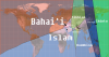
This is an intensely funny map. Thank you for posting it!This is my first attempt at a voronoi map. It is an attempt to show some major religions by Holy site, with each focal point representing a Holy site. I don't think it is perfectly accate, however.
Chris Wayan's Giant Bird Zone: Earth Edition![1] Assuming that all of the evaporated water leaves the mediterranean bassin. This may not be true as the air would need to rise ~3 km at the edges of the bassin so there would be some rainfall feeding back into the lakes, allowing them to grow larger.
(yes, I know "giant bird" is... a perpendicular understatement)
WorldRaj, but in VT-BAM?
*shivers*
(Also, this is quite clearly the English midlands and some Wales)
The Austrian Civil War of 1934
POD: Fighting between the Austro-Fascist State and the Social Democrats in 1934 Austria escalates into a full large scale civil war
Color-Scheme: THICC 2.2, Social Democrats and Austro-fascists are colored as ideologies (not countries)
Basemap used: VTBAM
A successful general strike and aggressive attacks by the "Republikanischer Schutzbund", the paramilitary of the Austrian Social Democratic Party, enables the Social Democrats to gain control over large parts of the country, and some of the larger cities. The Austrofascists maintain control over more rural regions and the West of the country.
Meanwhile Hungary intervenes to regain the Burgenland. The Kingdom of Yugoslavia tries to occupy parts of Carinthia. Czechoslovakia captures several villages around Bratislava as a security zone against the advancing Hungarians.
The Social Democrats in Austria used the Three Arrows as one of their symbols, meanwhile the "Kruckenkreuz" was heavily used by the Austro-Fascists.
Note: I haven't done enough research to develop a more realistic and plausible version of such a civil war. I also don't know which side would likely win such a conflict.
WorldRaj, but in VT-BAM?
*shivers*
Alex Richard's work on the world raj will get more and more detailed as it gets larger and larger, till he finally perishes many years from now, falling off a 40-foot map of feudal land divisions in central Worchestershire.
That reminds me of this video:Alex Richard's work on the world raj will get more and more detailed as it gets larger and larger, till he finally perishes many years from now, falling off a 40-foot map of feudal land divisions in central Worchestershire.
@Alex Richards, I hope you already have prepared for Alex Jr.s and Alex Jr. Jr.s!
WI: A more evangalizing Buddhism?
This map explores a world in which Buddhism, after its founding, is spread with more vigor and to even farther out places due to slight theological differences. It spreads far to the West, eventually piquing the interest of the Hellenics, particularly the small Stoic movement, which syncretized its beliefs with their own. From there, it spread, becoming known as the "Stoic Faith" in the Hellenic world. This map is around OTL 100 AD.
Also of note is "Aryabhatism," a relatively new branch of loosely Hindu thought based around the teachings of the holy man Aryabhatya, who is emphasizing the inherent "one-ness" of all the polytheistic pantheons as representations of one Divine God, an amoral deity who blesses those who follow his holy commands and curses those who do not. Aryabhatism is quickly gaining favor among the poor for its rejection of the caste system of the Magedyan Empire, a very decentralized empire which has managed to last more or less in its current form for the last 200 years.
In Europe, the Makedonians have managed to forge an empire, though a much smaller and more stable one than we saw IOTL. Time will only tell if they win in their struggle against the Etruscans. The Punic Kingdom is consolidating Hispania, and is looking to be a real naval power, but has lost its last four land wars and its prestige alongside them.
China is currently under the rule of a traditionalist Confucian emperor, the first in over a century, after the ruling Ma Dynasty, born of a peasant revolt, brutally overthrew the ruling Xianzhong Dynasty, liberal followers of Eoistic Stoicism (Buddhism.) “China” ITTL is not considered to include its Southern portion, which is largely ethnically, agriculturally, and culturally far different, and— more importantly— ruled by a powerful Viet Kingdom.
Let me know if there are any questions or if there is any interest in seeing a sequel map! There’s a lot of interesting ways a world like this can go.
.
Last edited:
Alex Richard's work on the world raj will get more and more detailed as it gets larger and larger, till he finally perishes many years from now, falling off a 40-foot map of feudal land divisions in central Worchestershire.
The World Raj will become a 1:1 model where we are the map and Alex Richard is King.
First time I a video on Jays channel I saw myself walking past him in the background kinda surreal.That reminds me of this video:
@Alex Richards, I hope you already have prepared for Alex Jr.s and Alex Jr. Jr.s!
Have you done Q-BAM and M-BAM?Slow going considering I'm still working.
- Status
- Not open for further replies.
Share: