Imitation is the sincerest form of flattery, is what they say.
I found his style of mapping was particularly useful for something like an ISOT map (it showed claimed boundaries and actual settled land well) and the color palettes were very harmonious, so I believed it was best to see how I can do it myself.
This took a while; but here is Christopher Scotese's Pangea Proxima as based on National Geographic's 2018 projection. The link has some cities and their locations which might interest you! Might make a sort of 'beginning of civilization timeline' out of it.
Waters definitely need improvement though, but i'll get to that at some point.
EDIT: Also just realised that i left some of the shallows a tad large in the far east there - i'll correct that at some point
The first map looks like the Southeastern US, Mexico and the Caribbean with a darker orange hue looking like a Dixie state, as someone already mentioned on here it could also be a Golden circle. Maybe the remnants of it after the CS collapsed, something among the lines of a Golden Circle EU?
The third map is reminiscent of Iberia. Could be simply Blueish Portugal and Spain with independent Aragon/Catalonia but there might also be Al-Andalus somewhere on this map. Plus whatever the white parts in the centre mean.
The second.... no idea. it might be rotated or have an "intentionally wrong/ancient" projection but I couldn't devipher it. It might be somewhat reminiscent of Italy but that's pretty much the only thing that comes to mind.
Hey all, given the amount of time I have right now, I decided it would be fun to put together an ISOT WI of a rather romanticized but really kinda unknown period, with massive amounts of inspiration taken from @XFE's fantastic ISOT works. It's my first time doing something like this and boy was it hard! Hope y'all enjoy.
~
Different eras, different places; no matter what happened, however happened, whats known is of nations and fleets have been simultaneously dropped on what appeared to be a virgin earth. Government duties slowed to a complete stop, ships arrived at places that didn’t exist anymore, and for a while it seemed the tumultuous relent of the sea was quiet and tranquil, if only for a moment.
1. The Eyalet of Tripolitania, the Regency of Algiers, the Beylik of Tunis, the Alouite Kingdom of Morocco, the Spanish territories of Melilla and Ceuta and all Barbary pirate fleets from 1715
2. The Republic of Pirates and all Caribbean pirate fleets from 1715
3. The Portuguese possession of Macau, the city of Canton, and Ching Shih's Pirate Confederacy from 1808
4. The Shiekhdoms of Abu Dhabi, Ajman, Dubai, Fujairah, Kalba, Ras al-Khaimah, Sharjah, Umm al-Quwain, the tribes in Qatar and Bahrain, and all Persian gulf pirate fleets from 1817
From the ends of the Atlas to the oasises of the Fezzan, the Barbary Coast covered a massive area and was a truly hard region to tame, with its melting pot of ethnicities, blazing climate, and of course, indomitable Sahara desert. However, even on the coast and in the seas where the mild Mediterranean climate breezed through came a new (and arguably worse) danger, and those of the Barbary corsairs. The endless razzias, raiding and campaigning against coastal settlements, made the pirates the Frenchman's hex and the Spaniard's bane.
When the Great Relocation (was what most people called it) happened, Morocco had been under a weak Alaouite Ismail bin Sharif, whose support of any Bedouin or Berber tribe he had none. It was dark times for Morocco for the first few decades; its said his rule was extinguished when a single Berber gentleman simply trotted to Fez and assassinated bin Sharif on the spot. His large slave population, the one that had supported his feeble rule, dispersed, and Morocco fell into factions of the once-again powerful tribes, and one man needed to stand up.
That man was Ahmed ben Abdellah ad-Dila'i. Being the grandson of a rival sultan of Ismail, he had been cast into exile into the Sahara Occidental, but came along with the Relocation. Seeing this as a godsend, ad-Dila'i and his already forged alliance of Sanhaja tribes painstakingly rallied other disparate tribes under his banner and became famous for brokering peace among hostile clans. Seeing how now bin Sharif's sons rivaled for the throne, ad-Dila'i decided to strike when the iron's hot. It came when Abdallah, the last son remaining, had shakily claimed title of Sultan with very little legitimacy, Ahmed stormed Fez what he had least expected it, and the conflict was qualmed. Ahmed knew to be more open-minded with the still-strong tribes and granted them large amounts of autonomy, a practice that still persists to this day.
Ahmed's reunification resonated with the other polities that had came along with the ride. Moroccoan pirates, now without villages to plunder, willingly joined as part of his navy to explore and see what else was there (though certainly not privateers, government employed pirates; there was no one else to raid but the Ottomans to the east, and the Ottoman territories that came along could swiftly crush Morocco still if they banded up). The Spanish cities of Melilla and Ceuta (the latter of which was in a month-long siege during the Relocation) heard reports of their home country vanishing, and the Spaniards, along with the Spanish armada stationed at Ceuta, fled north to try to create an emergency government. Ahmed, being still the renowned peace-broker, allowed the Spanish to take refuge near the northern Iberian coast, while the rest of Iberia would be under Moroccoan nominal control.
Things were quite different in the Ottoman realms. For one, the disappearance of the Ottoman Empire proper was very concerning for the Ottoman officials, and whats more now they were at the mercy of three large and very unforgiving states that was still barely under Ottoman control. Even so, life continued; the remaining Turks, now very paranoid of their legitimacy in the realms, called for a reconstruction of Istanbul. However, the economy dipped hard as the corsairs began came back empty-handed with empty shackles and no slaves to count.
Algiers, whose economy depended on this lucrative trade, began to implode as overworked European slave revolts became common. Warlords began to fester on the edges of Algiers, and about six years into the Relocation saw the Ottoman presence in Algiers ejected. However, with their own Ahmed-figure, Algiers would be slowly pieced together in isolation, though to this day Algiers still sorely misses the abundance of the enslavable population in the past.
Tunis fared better than Algiers, even though part of its economy still depended on the previous cargo the corsairs bought back. A re-integration program for the former Barbary pirates was created, and numerous religious madrasas, places of religious study, was erected to preserve the word of Islam. Al-Husayn I ibn Ali, the bey of Tunis at the time, ruled until his death, and many enterprising beys came after.
Tripolitania also had its own slump, but it was by far the better place to go. Most of the administration left the southern portions of the eyalet to the tribes, who would be semi-independent under the eyalet's control. Tripolitania became the Ottoman's pet project, and was soon bolstered to be the most stable and successful. However, under the watchful and steely surveillance of Karamanli Dynasty that took more control of the eyalet, Tripoli shook away Ottoman control violently in four decades and became a fundamentalist watchful state that was mostly authoritarian in all but name.
As Tunis finally overthrew the now barely-clinging Ottoman overlords in sixty years, all the former states signed a pact with the now rump Ottoman Empire in Istanbul that a checks and balances system would now be imposed on the successor states, and Morocco had its hand forced to agree to it as well. This method, though very simple and a bit unorthodox for the realms, would work very well and stave off any civil war in any state for the forseeable future. Many of the remaining pirate corsairs were recruited into large colonization efforts coordinated by the three states (though individual colonization is still something to be figured out by the states themselves), including a massive funneling revenue into rebuilding Mecca, and one Sultanate of Egypt (created by a joint effort by the three states), who is now independent but was a great investment for merchants and farmers alike. Now as the prosperous international center for trade with the other states around the world, with the cities of Fez, Tunis, Algiers, and Tripoli boasting massive populations and becoming a central hub for commerce. Maybe like what Ahmed had first thought of when they were thrown onto this unforgiving world with vast potential, the Relocation really was a godsend.
In 1715 in the Bahamas had a most peculiar state: The Republic of Pirates, an anarchist confederation with its main stronghold in Nassau with some remarkable democratic tendencies. While an enterprising idea and ahead of its time, its relevance dramatically dropped following the Relocation. When the magistrate of the republic, Edward Teach, realized that the Spanish city of Havana was gone when he sailed there, immediately called for a return to Nassau as fast as possible. Relief had taken over Edward when he realized his nurtured state continued to be there, but Nassau was in chaos from the sighting of what appeared to be Spanish and British ships spontaneously vanishing in the horizon, and a small crew of scouts reported Florida was filled with lush vegetation with no traces of human activity.
Without any external pressures on the republic, the barely suppressed rivalry between Benjamin Hornigold and Henry Jennings, two powerful pirates (the former of which having been Edward's mentor), had flared up almost immediately, and it took all of Edward's effort to mend the relations together. He proclaimed in Nassau that a civil war would indeed be the last thing the men of New Providence needed, and that new changes had to be made to how the Republic would be run. In five years, the Pirate Republic would be transformed into the Brethren's Confederacy, a loose polity that worked as a link to the various individual fleets. The once informal Code of Conduct was remolded into an Articles of Confederation-esque Constitution, majority rule for the pirate captains at the time was imposed (though Edward continued to be the loudest voice within it until his death), and a colonization program was set forth to settle the surrounding lands as their precious foreign cargo ships was no more.
More than a few fleets deserted upon hearing the new reforms, including that of Benjamin Hornigold. Hornigold still held the grudge with Jennings and had a soft spot with the British navy, something his comrades didn't share. He, along with a portion of his crew, decided to sail back to England to see if any activity was there, and if not he will start a new reign of Britain. He and his two ships and crew of 400 men left Nassau one and a half years into the Relocation, and they were never heard from again. Some say a typhoon had swept him overboard, others say rogue Barbary pirates overwhelmed and captured the ships. No matter what, there was substantial evidence that Hornigold's men never made it to Britain, and Britain itself would remain untouched until a settlement of British slave escapees is founded roughly seventy years after the Relocation near the site of London.
What followed was a slow transition from sea to land. Coastal villages are founded across the former lands of Cuba, Hispaniola, and Florida. Slavery became a general taboo slowly with descendants of African and mulatto pirates becoming equal with the whites. Some of the Jacobites within the fleets rose to leadership statuses and centralized authority. The ones who were more zealous founded colonies further inland, many of which collapsed and the survivors becoming semi-nomadic herdsmen. Some who wished to retain their old lifestyle began to loot Barbary ships coming from the east, something the Brethren's Confederacy fiercely denied had any connection with.
Today, in the diplomatic arenas, the Brethren's Confederacy is a more minor player compared to the giants of Islam in the Old World, and maybe it preferred to stay that way. The ways of life would be unrecognizable to the pirate who had ruled the seas before the Relocation; the Brethren's Confederacy now had trading and tourism as large pillars of the economy, something that would have been unheard of in the olden days. Only the eldest of men now would sit in a hookah bar or pub in Nassau or Waynetown and talk about the exploits of their ancestors. It was a much more simpler time for sure; but between trading/fishing and plundering/looting, by now most of the Caribbean could almost agree the former is the better case...
The Trucial Coast, formerly known as the Pirate Coast, found itself in a very strange situation following the Relocation. This was a time where the eternally divided emirates and tribes of the Middle East were at each other's throats and ruthless pirates, some of the worst the world has seen until the modern era, truly ruled the Persian Gulf. The British, already exasperated from dealing with depleted supplies by the the pirates, now found themselves cut off from the nucleus of operations in Bombay, and even worse, Britain. Their plans to broker a treaty with the dueling royal families of the Trucial Coast had to be done fast, but without any legitimacy now, the situation just reverted into the status quo, except with no foreign threats it turned to be much worse then before the Relocation.
It would be thirty years without any central administration in these dark times for the Trucial Coast. It was known as the "Eternal Follies" by the remaining British, who was forced to retreat into India where they built a settlement with what remained, and became a name that stuck. Now with the valuable resource-laden British ships gone, Saqr al-Qasimi, Sheikh of Ras al-Khaimah and Sharjah, ordered his privateer fleets to turn against the other emirates. From what was once skirmishes, now was full out war. No foreigner wanted to participate in the bloodshed that was the Trucial Coast; sheikhs could rise and be deposed in up to six times in a year.
This perpetual state of conflict meant mass migration out of the emirates. Many left to find more peaceful prospects near the Egyptian heartland, where potential was plenty. Others travelled south into the regions of Muscat and Oman which once occupied the one enemy all the emirates had, and some went into the Orient, hoping to make a fortune by starting the spice trade. This made the Arab diaspora massive, with some pirates drafted by foreign navies as mercenaries. Their traces can be found all over the world, from the Wahhabi merchant colonies in the Borneo to the notorious slave-dealers of Humaida, descendants from a powerful Qatari-Saud tribe, stationed in former Sao Tome and Principe.
A "Peacemaker" era followed as foreign embassies decided "enough was enough" and came to attempt to stop the fighting that otherwise impeded a region with much potential. At this point, only three of the original royal families remained, with the rest either completely exterminated or absorbed: Abu Dhabi, ruled by the merchant-driven and wealthy al-Nahyan dynasty; Ajman, though de-facto by the al-Nuaimi but really had the various scatterings of tribal leaders doing the work for them; and Ras al-Khaimah-Sharjah, where at this point the ruthless al-Qasimi and their dreaded pirates ruled supreme. Most of the army reserves have gone depleted for years, and the remaining royal families had planned for an armistice anyway. A series of truces followed, calling for an end to hostility and for an effort to lessen the unprecedented maritime lawlessness that defined this region. Over the years, more of the newer royal families (often breakoffs of the original dynasties or successful leaders for a well off settlement) would sign these truces, leading to a period of rather well-deserved peace within the region. Reconstruction followed, albeit painstakingly; cities like Dubai and Umm al Quwain, battered by torrents of shells, was rebuilt, and infrastructure slowly rebuilt.
Nowadays, the fruits of the reconstruction can be seen in the bustling streets of a rebuilt Dubai and other cities. Many of the al-Qasimi pirates who refused to the agreements of the truces were pacified by the other powers, and in over two centuries can ships pass the Strait of Hormuz relatively safely. From western India onward, the Emirates held the monopoly of spices and trading, bought over by the Cantonese and the Arabs. As a major stopping point for traders coming from the East, the Arab emirates have been blessed with a robust flow of goods. The dune cities of Arabia have now becoming some of the fastest growing cities in the world, and the people look hopefully for the Emirates of the Trucial Coast.
Having been an extremely important geopolitical location for trade and sea lanes, there was no doubt pirates would have taken advantage of the South China Sea. As a result, some of the world's most successful pirates have risen here, including Cheng I and his much more known bride Ching Shih, or Cheng I Sao of the Qing Dynasty. The Relocation had happened when Ching Shih was at the apex of her power, but also where she had the farthest to fall.
The presence of the then-Qing held city of Canton and the Portuguese lease on Macau was a double-edged sword; while this meant their lifeline for foreign ships could be continued for a bit longer, but the lack of the Qing dynasty in general meant the lucrative salt tax imposed on by Ching Shih was now nothing more. Adding to the friction that the Black and the Red Fleets had, times looked hopeless for Shih's Pirate Confederacy. She decided the best course of action was to offer amnesty to the Portuguese governor Bernardo Aleixo de Lemos e Faria before something like a mutiny implodes her fleet completely.
For Macau, Bernardo was not doing well with his formerly quiet possession turned inside out. Food was running out fast, and no further ships, Portuguese or otherwise, came to supply. An emergency lockdown over the city was declared by the Municipal. Canton fared even worse; the Qing mandarins had been overthrown by a very disgruntled Cantonese militia, and Macau needed as much people as possible to grow food and feed their rising population, and by this point any treaty with the rump Qing had been all but thrown out of the window. In about five years, Canton was substantially part of Macau, albeit the most unstable part of it.
Bernando next had to figure out the tricky situation of Ching Shih and her entire fleet offering sudden peace, though not without some terms that'd benefit the confederacy. At the end of the peace talks, Macau's ship armada more than doubled, and while most of the pirates joined the navy, the rest Bernando sent further inland to farm, seeing how most of them came from farming backgrounds and promised benefits that may or may not come. Some complied, but most were furious at the sudden riches to rags situation and displacement. Many of these Cantonese founded small shantytowns outside of Macau proper, and to this day their descendants live in the "Assentamentos", or the Settlements, showing the large financial inequality in Macau today. Disease followed, when a strain of the bubonic plague began spreading through the slums of Bela Vista and Adolfo Loureiro, where the smell of the death of people would characterize those neighborhoods to this day. It was barely stopped through the use of inoculation (Ching Shih had proposed the idea), but by the time it was barely stopped, 5% of people in Macau had passed, and smaller outbreaks would plague the city due to infrequent administration. The emergency lockdown would be lifted after three years, but it would remain in a substantial period of tension until reach with the outside world was made approximately fourty years after the Relocation. In this time, loose administration allowed for three polities to rise in Asia:
The Dàhǎi méngyuē (大海盟约), or the League of the Seas, was a molding of the descendants of three fleets from Ching Shih's confederacy and number of prospective traders. They are a strange reflection of the pirate confederation, but had no interest in looting and plundering and existed as a loose confederacy of coastal city-states that facilitated trade that came through the eastern hemisphere. It's ruled by a Maritime Council of Oligarchs, and is more interested in establishing trade posts across the world then penetrating further inland. There are rumors that some pirates of Chinese descent in some ports to this day are possibly connected to them, though.
The Baaifong Republic, located on the island of Ceylon, was an informal colony by Cantonese merchants following first contact with the Emirates. Almost the entirety of Macau's almost minuscule Indian population is located here, but as a stopping point for trade in the Indian sea, has made it extremely wealthy.
The Kingdom of Viet Nam was the product of the Vietnamese corsairs in the confederacy and the ethnic minority in Macau. The state is rather poor and most of its population practices sustenance farming, but it still exists from the amount of trading that goes through its ports, though its more or less propped up and under the larger Macanese umbrella.
Now, Macau has become a gem of the world, boasting over 500,000 residents and has an urban sprawl that stretches from Shangchuan Island to Pinghai Point, and is one of and perhaps the most diverse cities in the world. Some of the world's major financial headquarters is stationed here, along with numerous smaller trade cantons and guilds that have backgrounds from French to Arab. Despite its location as the farthest corner of a major human civilization, it is truly a rewarding place should one take the time to reach it, and is and continues to be one of the largest cogs for this strange but promising world.
With the roughest of the decades over, humans has learned to pick itself back up and cope with each other for survival. There was still so much out there to explore, and now perhaps humanity has been blessed another chance to start anew. As this collection of states slowly reintegrate themselves as the sole proprietors of the world's economy, many see themselves finally having a breather and finally settle down. However, with the turn of a century brings yet other changes. In Tripolitania, a more open-minded younger population begins to challenge the Karamanli who have sat on their thrones for as long as they have remembered; in Macau-held Cingapura, a large populist revolt threatens Macau's only overseas territory and the safety of the Strait of Malacca; and in the deserts of Arabia, a group of miners break open a stone wall in a cave, only to find a massive rush of slick black liquid shoot at the astonished miners, perhaps a fitting metaphor for whats to come with the dawn of the new century.
I don't know this type of map, what does it consist of?
I made this map on Paint of Windows (which explains the time I had to take to make it 🤔). 6 years ago with Paint I had deformed a map of Europe into a RP world. Then I reproduced the result on paper.
Then two or three years ago I decided to scan this drawing to make it more detailed and "clean". Redoing all the lines was the longest part of the job but I'm quite proud of the result.
Do you have any advice to give me so that I can redo the map at the Worlda scale ?
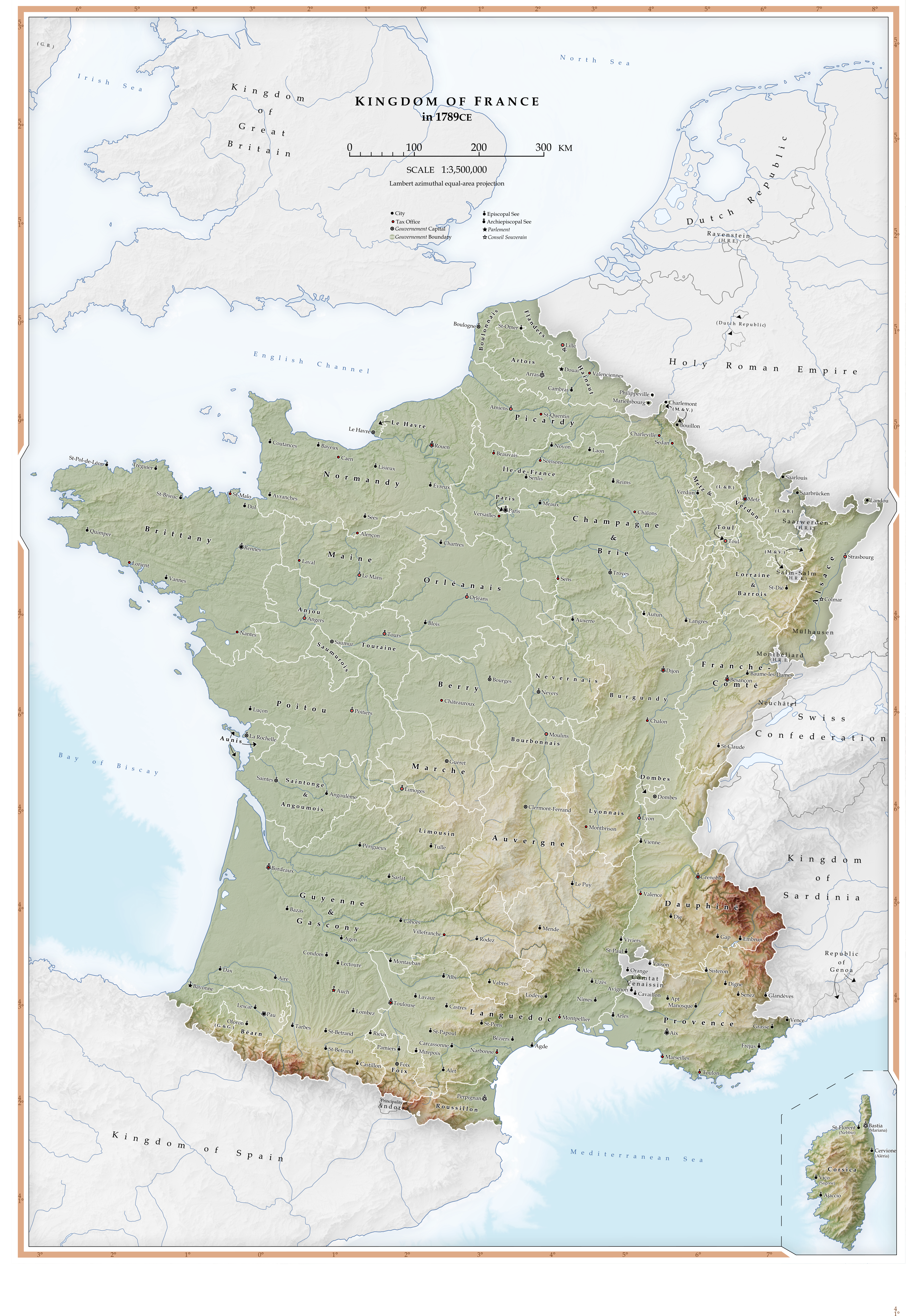
Map I've been making in quarantine of Revolutionary France, while my country is in lockdown. Playing around with different styles, and settled on this one. With most my maps, I aim to make my maps both legible and aesthetically pleasing. I think this style manages both, giving huge amounts of information regarding individual cities in France in 1789 without sacrificing topographical data and clear boundaries for both internal and external divisions.
EDIT: Once again, let me know if you have any feedback
Shaded relief from…
Jarvis A., H.I. Reuter, A. Nelson, E. Guevara, 2008, Hole-filled seamless SRTM data V4, International Centre for Tropical Agriculture (CIAT), available from http://srtm.csi.cgiar.org [Accessed March 2020]
Bathymetry from…
The GEBCO Grid, GEBCO Compilation Group (2019) GEBCO 2019 Grid (doi:10.5285/836f016a-33be-6ddc-e053-6c86abc0788e), available from https://www.gebco.net/. [Accessed March 2020]
Darby, H. C. & Fullard, H., 1970. The New Cambridge Modern History: Volume XIV Atlas. Cambridge University Press ed. Cambridge: Cambridge. p. 110
Boundaries of France from…
Darby, H. C. & Fullard, H., 1970. The New Cambridge Modern History: Volume XIV Atlas. Cambridge University Press ed. Cambridge: Cambridge. pp. 111, 115
Boundaries of German, Swiss, and Italian states from…
Darby, H. C. & Fullard, H., 1970. The New Cambridge Modern History: Volume XIV Atlas. Cambridge University Press ed. Cambridge: Cambridge. p. 132
Tax Offices from…
Darby, H. C. & Fullard, H., 1970. The New Cambridge Modern History: Volume XIV Atlas. Cambridge University Press ed. Cambridge: Cambridge. p. 112
Parlements and Conseil Souverains from…
Darby, H. C. & Fullard, H., 1970. The New Cambridge Modern History: Volume XIV Atlas. Cambridge University Press ed. Cambridge: Cambridge. p. 113
Episcopal and Archiepiscopal Sees from…
Darby, H. C. & Fullard, H., 1970. The New Cambridge Modern History: Volume XIV Atlas. Cambridge University Press ed. Cambridge: Cambridge. p. 114
Detail of Northern and Eastern Frontiers from…
Darby, H. C. & Fullard, H., 1970. The New Cambridge Modern History: Volume XIV Atlas. Cambridge University Press ed. Cambridge: Cambridge. pp. 108-109
Programmes used…
QGIS (Reference, Generating TIFF and Hypsometric tint to import into Blender)
Map I've been making in quarantine of Revolutionary France, while my country is in lockdown. Playing around with different styles, and settled on this one. With most my maps, I aim to make my maps both legible and aesthetically pleasing. I think this style manages both, giving huge amounts of information regarding individual cities in France in 1789 without sacrificing topographical data and clear boundaries for both internal and external divisions.
EDIT: Once again, let me know if you have any feedback
Beautiful map,
Bouillon was it's own thing and not part of the Three Bishoprics however and the boundaries of said Three Bishopric are a bit exaggerated
Ok, so, I'm sorry for the late reply, I haven't had time to write things up for a while. Before I start answering your questions, I want to remind you that this isn't super well thought out, so if you see anything that doesn't make sense, please don't judge me, but do tell me so I can try to fix it.
The general gist of the POD is that Prussia's boycott of the meeting of German Princes in 1863 does sort of the opposite of what it did IOTL, or rather, that Austrian diplomats are able to frame it in a way that benefits them. So, instead of Prussia's presence delegitimizing both the meeting and the idea of Grossedeutschland, it "proves" to the other German rulers that Prussia is not willing to let Germany unite unless it is in charge. Austria also presents its continued desire for a more decentralized confederation not as it resisting German unification, but rather as them "supporting the autonomy of the smaller German states".
This leads to the formation of a sort of "South German Confederation" (not officially called that, just centered in Southern Germany). Austria begins to improve relations with France as both share a fear of Prussia (Territorial disputes with Italy were pointed out as another potential reason for the alliance by @Comte de Dordogne in Explain the Alternate History map). Prussia also goes ahead with its North German Confederation more or less as IOTL.
The Prussians eventually go to war with Austria, who is aided by France and Prussia is defeated, though not too catastrophically. They lose Silesia to Austria but gain Upper Hesse. The Danes join later on on Austria's side and gain Schleswig, with the exception of Kiel, which goes to Austria. Austrian Holstein later gains independence. No Franco Prussian war means a prolonged life for the French Empire. Silesia is made into an independent state under a secondary Hapsburg branch to avoid an image of Austrian expansionism.
As Austria begins to further integrate with the German states, Hungary, Banat and Galicia go into revolt for fear of being dominated by a larger German population. The Austrians are unable to stop them and eventually accept this state of affairs, as it removes the main roadblock to German unification under Austria: their large minority populations. Hungary goes its own way, Galicia becomes the Polish Republic, and Banat joins Serbia (Austria supports this to weaken the independent Hungary). Croatia is kept by either the Austrian royals or another Hapsburg branch as a separate kingdom, outside of the federation, as is Venice. Southern Germany integrates more and more, until eventually, a united, federal state is formed, the German Empire.
Bosnia is not annexed, so the first world war is not over the Balkans (I haven't figured out much here yet but I was thinking Prussia and Russia might ally with each other). By the '20s though, Croatia forms a union with Serbia and Montenegro (maybe resembling the German Empire, wherein regional monarchies are maintained though more likely, the Hapsburg monarchs are deposed). Pan Slavism and particularly Yugoslavism was hugely popular at the time, and is unlikely to be stopped, even if in the long term its results would be unstable. Congress Poland also eventually gains independence and unites with Galicia a similar thing happens in the Poznan region. I'm strongly considering getting rid of the Polish corridor because it's to o convergent and unlikely to happen ITTL unless Prussia loses big in a war (this would mean I need to figure out how European tensions explode ITTL, which takes time that I currently don't have). Poland just has too large of a population and too strong of a separate identity from its occupiers for it to not break off once nationalism got to where it was. By the 1860s, there's no stopping Polish Independence without constant war.
[edit: There is also a minor POD during the Belgian revolution because I like me a nice greater Luxembourg]
I'm glad you like the map. Thank you for the complements.
Venetia should not be a duchy, that was a mistake on my part. It may or may not eventually be corrected.
Hanover is an independent German state, but has good relations with Britain and ok relations with Prussia.
Poland came from rebellions, though if you mean "why does the western border look so much like interwar Poland", like I said, I intend to rework that bit. The east is less convergent though, albeit not visible.
You have Austrian Silesia as a part of Moravia here. I expect it would either be united or reunited with Silesia here. Though perhaps Silesia would also be split into Upper and Lower for administrative reasons. I see it had some one other than the Austrian Emperor in charge there, so does make sense it would be as you show, even if having everything down there united in one country would seem somewhat ridiculous. The House of Liechtenstein is probably not happy about losing their autonomy, even if Vaduz and the neighboring area was just so they officially were Princes. I do not see Oldenburg working as the way you show it for a couple of reasons. It has lost its land around Lubeck, The main portion of the Grand Duchy is colored so as to look like it is wholly Prussian, yet it is both not connected by land to it as well as the remaining portion of Oldenburg, the one near the Bavarian Palantine, is shown as a member of the German Confederation. Also the issue of who the members of the Grand Ducal family are related to. The Danish, Russian, and a Greek royal families. They also had claim Holstein, with a bit of land swapping in the past with Denmark to clear up the borders. The Prussians expanded Oldenburg’s land in the area to connect their enclaves for not putting forth their claim to the land after the Prussians occupied the area. I can see a small storyline being made just on the subject of Holstein and Oldenburg, really.
Ahhh, and Hanover. It doesn’t have its southern portion here, yet that area is shown as being a member of the NGC. More likely to give that status to Brunswick. The Duke of it at one point (after the Prussians had occupied both) a claim to Hanover. One of the Princes came over for a funeral, fell in love with the Kaiser’s only daughter, and then married her after his dad abdicated all his titles and when he personally renounced all claims to Hanover. And then there is the fun dynastic stuff with the the House of Oranj-Nassau or how the Prince of Wales once was almost the Duke of Coburg-Saxe-Gotha.
Also, up in the north you might want to work in the borders between the small cities. Wishing the NGC. I can see the borders faintly, but they are very blurred and mellow.
Oldenburg: The contrast with neighboring colors just makes it look like it's in the Prussian colour, it is not. That does need to get fixed though, thanks for pointing it out.
Oldenburg and Holstein: I got nothing. Sorry.
Hanover: It just kind of stayed independent because I liked the look TBH, and the loss of the south was just to reduce border gore, I will eventually try to either explain or get rid of this, but rn I don't have time.
One of the nations of my "realistic fantasy" universe (you can find the blank map on the previous pages). I haven't finished the map, e.g. the regions with numbers don't all have names. But anyway!
Let me introduce you to the Consulate of Minerva, a state that unified the continent not by war but by ""democracy"". But the southern states reproached a monopoly by the northern states and quickly sought independence. A five-year war followed, in which the southern states were crushed by the "Unified Consulate of Minerva" and its two-legged tanks: the Laspalles. The defeat was as humiliating as the state of Petroce abandoned its brothers to join the Consulate by opening its cities and ports to the armies of the north. At the end of the conflict, the southern states were put under military occupation (except Petroce) and the last uprisings are about to be crushed.
The regions in dark blue are those under military rule. The regions in blue are fully integrated into the Consulate, the light blue regions are light protectorates of the Consulate. Grey areas are claimed by the Consulate of Jure but are not de facto owned by the Consulate. The number "4" corresponds to the regions taken from the southern states. Roman numerals are the old southern states reintegrated.
If I had to compare the Consulate to an OTL state, it would be the messed-up mix of Napoleon's Consulate with a US touch of "federalism", all sprinkled with a "slightly Nazi" ideology on the edges ("the guys in the south are lazy, we should put them in camps to make them work better 🤪 ").
This is the beginning of my universe where the hero was an petrocian soldier crushing the last rebels of the south on behalf of the Consulate in a mecha. Do you have any questions?
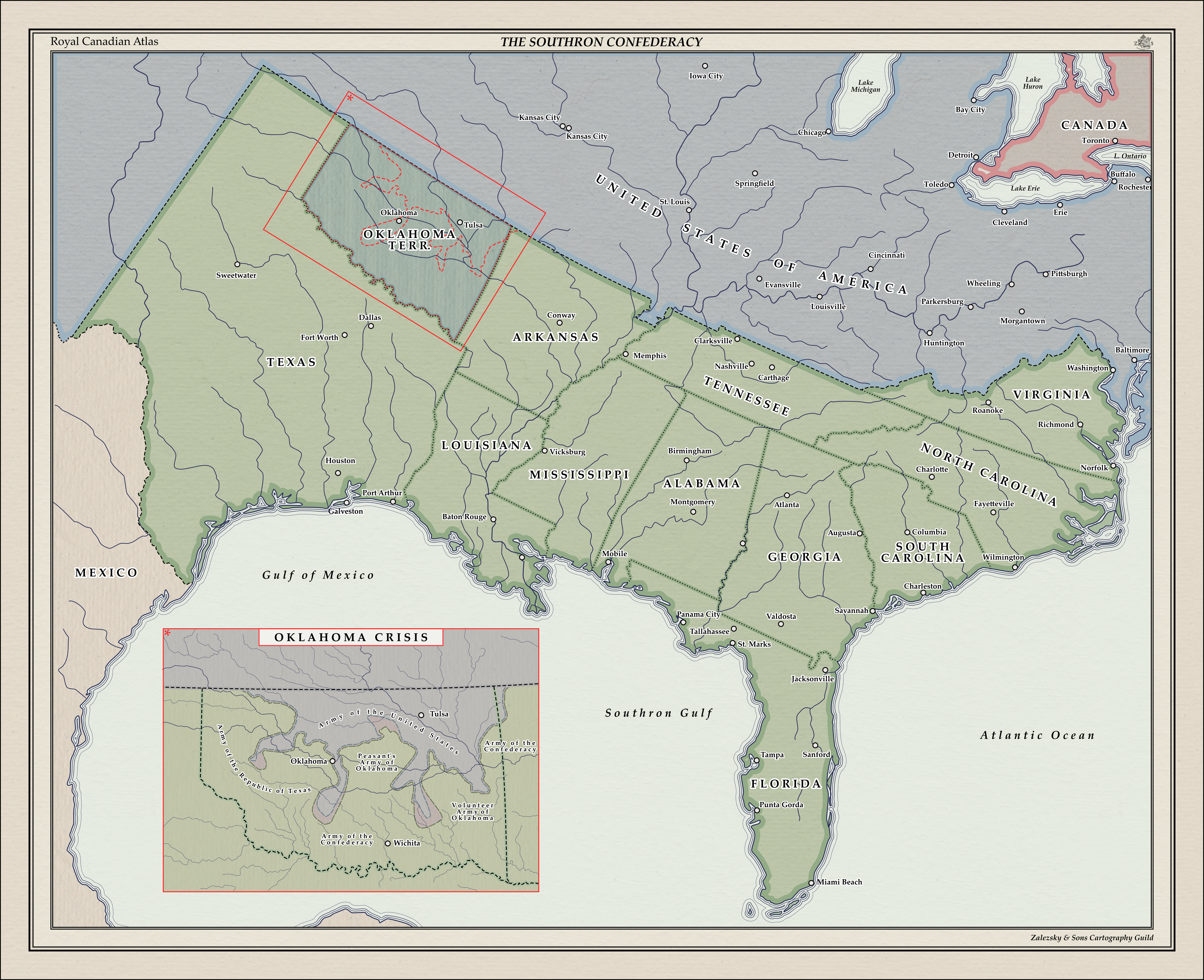
Southron Republic: Oklahoma Crisis
Inspired by and her recent work Southern System
This was mostly a test of style. If you wish to write a backstory for this scenario in the comments I will be more than happy to add it to the description and credit you.
If asked, probably no one in either Yankeedom or Dixie would have guessed that it would have started up again over a bunch of poor whites in Oklahoma. And yet, that just goes to show you how much sense people have.
When a series of bad harvests combined with a particularly poorly-timed lowering of wheat tariffs led to a bunch of farmers' uprisings out in the ass-end of nowhere, Richmond's reaction was to hem and haw and state's rights and then do nothing. Some elements of the Oklahoma State Assembly tried to fix things through introduction of price guarantees, but the cattle lobby stopped those bills dead, and so the people just got hungrier and angrier.
On the Fourth of July, just as the wheat harvest was coming to an end, the "Peasant's Assembly of Oklahoma" sent a letter to Richmond declaring their independence from the CSA, as well as 12 more: one for each state capital, and an extra for Oklahoma City.
Richmond's response, unsurprisingly, was to call up the regiments and as well as immediately deploying the Army of the Confederacy itself, which was intended to either frighten the "peasants" into submission, or to form the nucleus for the states' regiments to form around. By mid-August, much of central Oklahoma was under the control of the Peasants' Army, and the Texans had just dug in outside of Oklahoma City to wait for support from the rest of the South before they made their push to retake the town.
That opportunity would have to wait, as August 17 saw the first Bluecoats cross the Missouri Line. The propaganda from Washington said something about how "the rightful government of these United States cannot ignore the voice of any American crying for freedom", but somehow they ignored those voices quick enough when the Oklahomans told the Yankees to pack up their carpetbags and go back home. But if there's anything Yankees are good at, it's putting their nose where it isn't needed and not listening to others, and so they just pushed forward, grabbing most of the north of Oklahoma and taking care to grab OK City before pushing south, mostly leaving the central portions under Peasant control.
It surprised everyone (but the true, proud Oklahomans!) when the Peasants' Army woke up one morning and took 15,000 sleeping Yankees prisoner, as well as cutting a hole in the middle of their lines.
By this time, the Army of the Confederacy was well and truly forming up, and between them, the Texans, the Peasants, and the Oklahoman Volunteers that had originally been raised to combat the uprising, they'd brought more guns to bear than the Yankees' small "expeditionary force".
Christmas Day, 1899 finds Southron lines overlooking Yankee trenches and staring down the latest generation of Yankee automatic gatling, as recruits bang their drums all across the United States and Congress holds a special emergency session in Washington to try and declare a war. Elsewhere, Southron diplomats and merchants wine and dine European arms manufacturers while quiet conversations are held in London, Paris, and Berlin.
1900 is going to be one hell of a new year.
The Oklahoma crisis 1909 after winning their independence in the American Civil War the South trying to take Oklahoma off of the Union. This is not the first crisis that the union the South have had after the collapse of the front and the fall of Washington to the South and 1862 there have been calls for the South to own all of Oklahoma but the calls would have been answered until 1909 when Confederate president Woodrow Wilson called for a referendum in Oklahoma. Do you know of course didn't not want to read them what's the part of Great Britain had to kneel. The referendum results turned out mixed with half the state wanting to go to Confederates and the other half wanted to stay with the Union. tensions and more and more troops for pushed into the state the crisis. People called for war against the South for trying to take their state the US Congress look through the is options option one have a two front war with Great Britain and the South option 2 give the Confederates Oklahoma. More tension fired. Fighting broke out in the streets over there over the opinion of what Oklahoma should do. It all ended up what the Confederates sending an ultimatum supported by the Confederate Congress Woodrow Wilson sent the ultimatum. Did the United States of America Oklahoma or War which one will they choose.
The Oklahoma Crisis was an international crisis between the newly-independent CSA and the United States, featuring brief intermittent active warfare.
The Crisis stemmed from the disputed status of Oklahoma; a territory at the time of the civil war, the state never officially issued a declaration of secession, but the Confederate States Congress nonetheless admitted the entire Indian Territory as the State of Oklahoma in 1871. After the Peace at Huntsville, the United States continued to claim the state as its own territory due to its lack of declaration.
Early mediation failed due to a combination of noncooperation and ongoing tensions elsewhere, leading to border skirmishes in 1873, which rapidly escalated until they more resembled an invasion, held off by a ragtag assembly of Confederate armies. Confederate President Stephens successfully reached out to Britain to act as mediator in October 1873, leading to the Guthrie Conference of 1874.
Whilst the Conference led to the USA officially ceding Oklahoma to the CSA, it is widely regarded as a strategic victory for the US; the Arizona Territory and western portions of Texas, which had long expressed animosity towards Richmond, were granted the right to secede from the Confederacy at their pleasure - as they indeed did several years later, joining the US as Arizona and El Paso respectively. It is considered an early contributor to the collapse of the CSA, as funding for Oklahoma armies significantly drained the already depressed treasury and the loss of western territories caused widespread morale loss.
Known in the north as the Oklahoma war or in the south the sequoyah war was fought between the United States and the Confederate States over the indian territory from April 30th 1881 to March 1886. The results were the USA occupied the Oklahoma territory for 10 years as well as annex the Arizona territory and the el Paso region of texas
This map is supposed to be roughly in the same timeline as my last India map,
In this timeline, slight differences in the French Navy by the time of the war of austrian succession result, beside a slightly more succesful first carnatic war as shown in the previous map, in the Duke of Anville's expedition not being delayed, and thus not being struck by storms. The Expedition, the largest transatlantic one ever launched at the time succeeded in retaking Louisbourg, but the Duke had... special orders from the Kingtelling him to deport the Acadian who wouldn't pledge aliegance to him to "the english colonies", in this timeline Acadian, who by that point had to be neutral to survive in the contested regions, are not so enthusiastic to see such a large occupation force led by an admiral who isn't the most diplomatic, and a bar fight quickly snowballs into a small scale insurgency in Louisburg, the over zealous Duke did not hesitate and applied the king's order to deport most acadians, which were of little use to the crown, around louisbourg, leading to a general revolt as most of the other inhabitant feared for their lives, alas the large expedition force broke them and, on their way to bombard Boston, deported many to the nearest British colony, the part of Western Main administered by Massachussets. The disposessed Acadians soon had to flee Massachussetsian who were extremely angry at the loss of Louisburg, whose taking was a soure of pride, and the devastation of Boston by the French Navy and pursued them, the Acadian then fled inland, to the north and then the west, they soon faced Iroquois who for the most part were not too happy of this intrusion, as their numbers were dwindling the Acadian had no choice but to continue their "Grande Traversée" westward, until they reached the Niagara falls, there they found Seneca Iroquois, the westernmost people of the Haudenosaunee, in an almost miraculous battle the Acadian managed to defeat them and cross the Falls. What they found beyond were a destroyed people, descendant of the Neutral Nation who were defeated by the Seneca a century before. The Ataouandron (Neutral) as they were called were grateful to the Acadian as they defeated their long-standing enemy, and they displayed generosity and hospitality to the Acadian, whose numbers had been reduce to a little more than a couple thousands, from over 15,000 a year before. From this meeting of two separate people a new nation would eventually be born, Onhetsa, from the name the Ataouandron gave to their land.