Proposals and War Aims That Didn't Happen Map Thread

Crazy Boris

Banned
In 1945-1947 as States/Lander were being formed within the various occupation zones in Germany, the future Minister-President of the State of Hanover (formed in August 1946 and precursor to the State of Lower Saxony), Hinrich Wilhelm Kopf, had been suggesting (based off of a 1920s reform plan for the administration within the German Empire) from June 1945 through to April 1946 that a State of Lower Saxony be formed incorporating Hannover, Brunswick, Oldenburg, Schaumburg-Lippe (which are the areas that formed the current State/Land of Lower Saxony) as well as the former Prussian district of Minden-Ravensberg, the district of Tecklenburg and the state of Lippe. These latter territories ended up in what is now North Rhine-Westphalia, but had they been incorporated into Lower Saxony it would have looked like this:

View attachment 531541

Dark Red - State of Hannover

Light Red - Brunswick, Oldenburg, and Schaumburg-Lippe later added to form Lower Saxony with the State of Hannover

Light purple - Minden-Ravensberg, Tecklenburg and Lippe


A counter-proposal by politicians from Oldenburg and Brunswick would have seen what is now Lower Saxony divided into roughly 3 equal states:

Weser-Ems (brown on the map below), Hannover (mustard on the map), and an enlarged Brunswick (gold on the map)

View attachment 531542

I have to wonder, why was Bremen not included in these proposals? Was it just because it was in the US occupation zone instead of the UK occupation zone?
 
I have to wonder, why was Bremen not included in these proposals? Was it just because it was in the US occupation zone instead of the UK occupation zone?
I think it was/still is its own state/district?

Yup, it was because it was part of the US zone. Modern proposals for merging Lower Saxony and Bremen exist, but pre-1949 there were no proposals to merge areas which weren't part of the same occupation zone, with the one exception of Bremerhaven, which actually got added from Lower Saxony to Bremen in 1947 after having been detached from it in 1939 (though it was also slightly expanded by merging with a few additional towns).
 
I have to wonder, why was Bremen not included in these proposals? Was it just because it was in the US occupation zone instead of the UK occupation zone?

Actually the second proposal was supposed to have Bremen as part of Weser Ems. Good catch. I'll fix it now.
 

Skallagrim

Banned
That is true, but it's not as though there weren't already borders, however contrived, for a Tajik polity.
Remember, this is a plan from the desk of Alfred Rosenberg. You know, Alfred "Aryans may have descended from an advanced Antediluvian civilisation, and also something-something Holy Grail hidden by the Cathars, you guys!" Rosenberg. That guy. Even Himmler didn't read his book.

His understanding of how ethnic groups related to each other was... limited.

When even Himmler thinks you are too weird...
We are reaching levels of crazy that should be impossible.
 
Fair.

Though the Tajiks lived in the region commonly referred to as Turkistan, despite not being Turks to begin with.

Didn't the Nazis also classified Bulgarians as Turks as an excuse of cooperating with Slavs who they perceived as sub-human? they did the same with the Croats, saying that they were Germanic.
 
1585067245652.png

Partially the successor of the Chechen Republic of Ichkeria, The Caucasus Emirate was the aim of the jihadist group of the same name, who wished to expel Russian influence from the region and establish an Islamic state in the region. The group existed from 2007 until 2015, when all but two very small remnant factions joined up with ISIL.
 
Partially the successor of the Chechen Republic of Ichkeria, The Caucasus Emirate was the aim of the jihadist group of the same name, who wished to expel Russian influence from the region and establish an Islamic state in the region. The group existed from 2007 until 2015, when all but two very small remnant factions joined up with ISIL.
Can we acknowledge Islamic State's laughable plans to conquer everything from Iberia to Indonesia? Baghdadi was insane with his ideas.
 
Can we acknowledge Islamic State's laughable plans to conquer everything from Iberia to Indonesia? Baghdadi was insane with his ideas.

Didn't ISIS just want a worldwide caliphate as a world government? just paint the entire map in black and we're done.

Also, did the real Chechen Republic of Ichkeria also include Ingushetia, or just Chechnya?
 
Didn't ISIS just want a worldwide caliphate as a world government? just paint the entire map in black and we're done.

Also, did the real Chechen Republic of Ichkeria also include Ingushetia, or just Chechnya?
Just Chechnya as far as I know, but the emirate just decided "Hey, let's take everything and redraw the borders!"
 
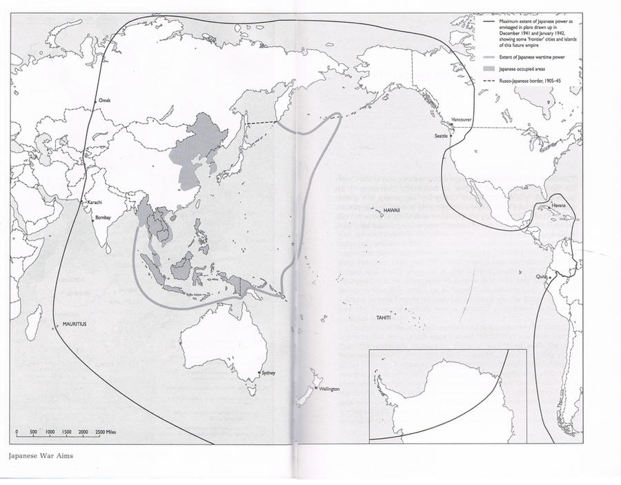
About Imperial Japan's extremely optimistic plans, does anyone knows what is the source of Japan's "Government-General of Central America"? most ASB Axis Victory maps portray all of Central America and the Caribbean as Japanese-controlled territories, but I have a hard time believing this even by WWII Japan standards, did they actually plan that?

Is this mentioned somewhere in Visions of Victory by Gerhard Weinberg? I do not have the book yet but it is apparently a great book to see the plans of the Axis for use in fictional worldbuilding and mapmaking.

greater-east-asia-co-prosperity-sphere-i-png.109143


The only source that mentions it is this museum website straight from 2008: http://pwencycl.kgbudge.com/G/r/Greater_East_Asia_Co-Prosperity_Sphere.htm

There is also this interesting map from a 2010 DeviantArt post mentioned on a thread here also from 2010, it doesn't seems to be fanart to me, so not sure of which source it comes from, the only other internet site featuring this map is some sketchy Korean website, but I obviously don't speak Korean.


Last edited:
View attachment 532843
Partially the successor of the Chechen Republic of Ichkeria, The Caucasus Emirate was the aim of the jihadist group of the same name, who wished to expel Russian influence from the region and establish an Islamic state in the region. The group existed from 2007 until 2015, when all but two very small remnant factions joined up with ISIL.
Looks an awful lot like the Mountainous Republic of the Northern Caucasus
 
According to reddit this was Atatürk's vision what Turkey's borders should be...
seems similar to the Misak-ı Millî, the last six decisions made by the Ottoman Parliament which set out what they wanted to happen to the state's remaining unoccupied territories and border territories with Turkish populations. notably this doesn't include nearly as much of the Balkans but does at least keep the posibility of retaining a lot more of the Levant and Arabia (in the map from Wikipedia below, the hatched areas' status was to be determined by referendum).
Misak-i_milli.png


I believe I actually made a WorldA recreation of this a while ago. should take another look at that, see if it should be revised at all.
 

ST15RM

Banned
About Imperial Japan's extremely optimistic plans, does anyone knows what is the source of Japan's "Government-General of Central America"? most ASB Axis Victory maps portray all of Central America and the Caribbean as Japanese-controlled territories, but I have a hard time believing this even by WWII Japan standards, did they actually plan that?

Is this mentioned somewhere in Visions of Victory by Gerhard Weinberg? I do not have the book yet but it is apparently a great book to see the plans of the Axis for use in fictional worldbuilding and mapmaking.

greater-east-asia-co-prosperity-sphere-i-png.109143


The only source that mentions it is this museum website straight from 2008: http://pwencycl.kgbudge.com/G/r/Greater_East_Asia_Co-Prosperity_Sphere.htm

There is also this interesting map from a 2010 DeviantArt post mentioned on a thread here also from 2010, it doesn't seems to be fanart to me, so not sure of which source it comes from, the only other internet site featuring this map is some sketchy Korean website, but I obviously don't speak Korean.


the wikipedia article on the geacps mentions it.
 
Top