Thande
Donor
As noted below, I used to do this a lot. Check out my old thread here for more (I'm not bumping it as it hasn't been active for 2 years).
As periodically happens about 14 months, possibly driven by the fact that US states count their votes so damn slowly I can't finish all the Super Tuesday primary maps yet, I woke up this morning with an idea of how to fiddle with old US elections in an ASB way to produce some interesting results.
The US Electoral College and Senate are frequently criticised for a number of reasons. While the US founding fathers certainly regarded their new country as being a confederation of sovereign states, and thus it should be expected that states should have less than absolutely proportional representation by population, the deviation between the largest and smallest states in 2020 has drastically increased from where it lay in 1788. California has a population (and economy) larger than most countries and, based on the 2010 census, has a staggering 66 times more people than the smallest state, Wyoming. Yet each state has two Senators. Those Senators and each state's Governor are frequently treated as having equal credibility and experience when running for president or being appointed to a presidential cabinet or ambassadorship. Which is like treating the job of Prime Minister of Canada or Spain as being equivalent to the job of Prime Minister of Montenegro or the Solomon Islands.
This inequality of population is not the only reason why the current US constitutional arrangements are frequently criticised, but I'd argue it's often the root of the others. In this thread I propose a completely ridiculous and unworkable solution to this - which is no less likely to be adopted as any of the 'serious' proposals for reforming the electoral college etc made,as you can't have a probability lower than zero. So let's have a bit of fun, shall we?
Based on the 2010 census, California has a population of about 37 million; a big gap follows before we get to number 2, Texas, at 25 million; another big gap to number 3, New York (which has now been overtaken by Florida, but I'm using 2010 numbers) at 19 million; Florida 18 million...and then we start the slow fall down to the minnows. The mean average for a US state's population is just 6.1 million and the median just 4.4 million, illustrating how many more smaller states there are and just how top-heavy this list is. If we want to get rid of that ridiculous 66 to 1 ratio between California and Wyoming, we're going to have to do something about this. What ratio should we consider tolerable? For the sake of argument, let's say 2 to 1. My plan outlined below achieves this goal, just; the ratio from the biggest to the smallest state is 1.99 to 1.
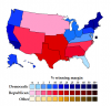
How to do this? Merge smaller states into bigger ones, and make one (1) partition of an existing state, because California is absurdly big. The biggest population we'll allow is just over 25 million (Texas) and the smallest is 12.6 million. Of course, you can't just use the mathematically most pleasing method of merging states to get as close to an average population as possible, because that would link up states on opposite sides of the map. Instead, I've used a combination of geographic closeness and historical cultural regions to try to produce slightly more sensible combos. Emphasis on 'slightly'. The US does have recognisable cultural regions but they don't neatly follow state boundaries, and there are many states, such as Oklahoma and Missouri, which fall into several regions or have internal divisions themselves. The goal here is to avoid dividing any state (except California) so I have not done this. So some of these combos are a bit arbitrary, and also many of them have silly and arbitrary names - which is fine because that's how a lot of the original states got their names anyway.
Here's a rundown of the state combos from largest to smallest, followed by a map. I have also apportioned electoral votes based on the House total of 435 plus 2 senators each (thanks to @Ares96 for his help with this).
Texas (25,145,561, 37 EVs): Unchanged from OTL. Well, they're the biggest state now, that should make them happy.
South California (23,933,989, 36 EVs): Yes, even after you chainsaw California in half, it still almost makes it to the top spot. This is the most common definition of SoCal, taking in the ten counties of Imperial, Kern, Los Angeles, Orange, Riverside, San Bernardino, San Diego, Santa Barbara, San Luis Obispo and Ventura.
Atlantea (21,494,273, 32 EVs): Pennsylvania + New Jersey. Look, Pennsylvania and New Jersey have an ideal combo name - the river that forms their border. The river which is called the...Delaware. So shut up, it was this or "Pennjersey".
Erie (21,420,144, 32 EVs): Michigan + Ohio Yes, I know Michigan and Ohio hate each other and have a sports rivalry and a border war. So do England and Scotland, but we've stayed together for 300 years, so shut up. Another one where I couldn't come up with a very good name.
Roanoake (20,864,871, 31 EVs): Virginia + West Virginia + Kentucky + Maryland + Delaware. Named for the first English colony in the New World, that one which ties with the Marie Celeste for 'alleged spooky mystery which is not even slightly mysterious if you actually read to the end of the article'. Partly based on the old Virginian claims to what became Kentucky.
Carolina (20,506,952, 31 EVs): North Carolina + South Carolina + Tennessee. Self-explanatory; again, partly based on the old North Carolinian claim to what became Tennessee.
New Germany (20,471,001, 31 EVs): Idaho + Wyoming + Montana + North Dakota + South Dakota + Nebraska + Iowa + Minnesota + Wisconsin. OK, this is probably the weirdest one. But the Plains are so un-populous that you're inevitably going to end up with something huge or silly or both. These states do loosely share a lot of German ancestry (and Scandinavian) so there's the origin for the name. Yes I know you could also put Wisconsin with Illinois or Michigan, but those don't work so well for getting equal-ish numbers.
LaSalle (20,042,686, 30 EVs): Named for that French explorer what explored things, this is essentially the 'South Central' region minus Texas. A bit of a mish-mash but, as I said above, Oklahoma and Missouri are two of the most debatable region-wise so might as well kill two birds with one stone.
New York (19,378,102, 29 EVs): Unchanged from OTL.
Wabash (19,314,434, 29 EVs): Illinois + Indiana. There are lots of good river or tribal names for the area, but annoyingly most of them stick neatly within the state boundaries.
Apachea (18,944,828, 29 EVs): Colorado + Nevada + Utah + Arizona + New Mexico. Isn't it weird how everyone agrees the 'South West' is one of the better-defined regions of the country culturally, yet nobody has a good name for it? This is based on the Apachean native language family (including the Navajo and so on), not just the Apache tribe.
Florida (18,801,310, 28 EVs): Unchanged from OTL.
Yazoo (17,434,686, 28 EVs): Georgia + Alabama + Mississippi. Named ultimately for the Yazoo tribe formerly occupying these areas, who lent their name to the 'Yazoo Land Scandal' which was the original reason for Alabama and Mississippi being split off from Georgia.
North California (15,602,664, 24 EVs): The remainder of California minus the 10 southern counties.
New England (14,444,865, 22 EVs): Massachusetts + Rhode Island + Connecticut + Vermont + Maine. Too much of a recognisable cultural region to avoid, even though it's on the titchy side, and there's no geographic way to link it to anywhere else anyway as New York gets in the way.
Pacifica (12,626,146, 20 EVs): Washington state + Oregon + Alaska + Hawaii. I definitely thought Washington was bigger than this, incidentally. Even with the two non-CONUS states stuck on (look, they definitely both have Pacific coastlines, alright) the Pacific Northwest is a much tinier slice of the US population than I thought it was. But oh well.
(...and the District of Columbia is unchanged because this may be a silly ASB WI but we have to have some standards for plausibility)
This leaves us with a situation where we have no more than a 2 to 1 ratio of inequality between the population of the biggest and smallest states, with an average state size of 19.4 million and an average electoral vote of 29.2, with relatively little deviation from these. Each state's Governor and Senators now have roughly equivalent and comparable jobs.

Does this solve all of America's political problems? NOW READ ON...
As periodically happens about 14 months, possibly driven by the fact that US states count their votes so damn slowly I can't finish all the Super Tuesday primary maps yet, I woke up this morning with an idea of how to fiddle with old US elections in an ASB way to produce some interesting results.
The US Electoral College and Senate are frequently criticised for a number of reasons. While the US founding fathers certainly regarded their new country as being a confederation of sovereign states, and thus it should be expected that states should have less than absolutely proportional representation by population, the deviation between the largest and smallest states in 2020 has drastically increased from where it lay in 1788. California has a population (and economy) larger than most countries and, based on the 2010 census, has a staggering 66 times more people than the smallest state, Wyoming. Yet each state has two Senators. Those Senators and each state's Governor are frequently treated as having equal credibility and experience when running for president or being appointed to a presidential cabinet or ambassadorship. Which is like treating the job of Prime Minister of Canada or Spain as being equivalent to the job of Prime Minister of Montenegro or the Solomon Islands.
This inequality of population is not the only reason why the current US constitutional arrangements are frequently criticised, but I'd argue it's often the root of the others. In this thread I propose a completely ridiculous and unworkable solution to this - which is no less likely to be adopted as any of the 'serious' proposals for reforming the electoral college etc made,as you can't have a probability lower than zero. So let's have a bit of fun, shall we?
Based on the 2010 census, California has a population of about 37 million; a big gap follows before we get to number 2, Texas, at 25 million; another big gap to number 3, New York (which has now been overtaken by Florida, but I'm using 2010 numbers) at 19 million; Florida 18 million...and then we start the slow fall down to the minnows. The mean average for a US state's population is just 6.1 million and the median just 4.4 million, illustrating how many more smaller states there are and just how top-heavy this list is. If we want to get rid of that ridiculous 66 to 1 ratio between California and Wyoming, we're going to have to do something about this. What ratio should we consider tolerable? For the sake of argument, let's say 2 to 1. My plan outlined below achieves this goal, just; the ratio from the biggest to the smallest state is 1.99 to 1.
How to do this? Merge smaller states into bigger ones, and make one (1) partition of an existing state, because California is absurdly big. The biggest population we'll allow is just over 25 million (Texas) and the smallest is 12.6 million. Of course, you can't just use the mathematically most pleasing method of merging states to get as close to an average population as possible, because that would link up states on opposite sides of the map. Instead, I've used a combination of geographic closeness and historical cultural regions to try to produce slightly more sensible combos. Emphasis on 'slightly'. The US does have recognisable cultural regions but they don't neatly follow state boundaries, and there are many states, such as Oklahoma and Missouri, which fall into several regions or have internal divisions themselves. The goal here is to avoid dividing any state (except California) so I have not done this. So some of these combos are a bit arbitrary, and also many of them have silly and arbitrary names - which is fine because that's how a lot of the original states got their names anyway.
Here's a rundown of the state combos from largest to smallest, followed by a map. I have also apportioned electoral votes based on the House total of 435 plus 2 senators each (thanks to @Ares96 for his help with this).
Texas (25,145,561, 37 EVs): Unchanged from OTL. Well, they're the biggest state now, that should make them happy.
South California (23,933,989, 36 EVs): Yes, even after you chainsaw California in half, it still almost makes it to the top spot. This is the most common definition of SoCal, taking in the ten counties of Imperial, Kern, Los Angeles, Orange, Riverside, San Bernardino, San Diego, Santa Barbara, San Luis Obispo and Ventura.
Atlantea (21,494,273, 32 EVs): Pennsylvania + New Jersey. Look, Pennsylvania and New Jersey have an ideal combo name - the river that forms their border. The river which is called the...Delaware. So shut up, it was this or "Pennjersey".
Erie (21,420,144, 32 EVs): Michigan + Ohio Yes, I know Michigan and Ohio hate each other and have a sports rivalry and a border war. So do England and Scotland, but we've stayed together for 300 years, so shut up. Another one where I couldn't come up with a very good name.
Roanoake (20,864,871, 31 EVs): Virginia + West Virginia + Kentucky + Maryland + Delaware. Named for the first English colony in the New World, that one which ties with the Marie Celeste for 'alleged spooky mystery which is not even slightly mysterious if you actually read to the end of the article'. Partly based on the old Virginian claims to what became Kentucky.
Carolina (20,506,952, 31 EVs): North Carolina + South Carolina + Tennessee. Self-explanatory; again, partly based on the old North Carolinian claim to what became Tennessee.
New Germany (20,471,001, 31 EVs): Idaho + Wyoming + Montana + North Dakota + South Dakota + Nebraska + Iowa + Minnesota + Wisconsin. OK, this is probably the weirdest one. But the Plains are so un-populous that you're inevitably going to end up with something huge or silly or both. These states do loosely share a lot of German ancestry (and Scandinavian) so there's the origin for the name. Yes I know you could also put Wisconsin with Illinois or Michigan, but those don't work so well for getting equal-ish numbers.
LaSalle (20,042,686, 30 EVs): Named for that French explorer what explored things, this is essentially the 'South Central' region minus Texas. A bit of a mish-mash but, as I said above, Oklahoma and Missouri are two of the most debatable region-wise so might as well kill two birds with one stone.
New York (19,378,102, 29 EVs): Unchanged from OTL.
Wabash (19,314,434, 29 EVs): Illinois + Indiana. There are lots of good river or tribal names for the area, but annoyingly most of them stick neatly within the state boundaries.
Apachea (18,944,828, 29 EVs): Colorado + Nevada + Utah + Arizona + New Mexico. Isn't it weird how everyone agrees the 'South West' is one of the better-defined regions of the country culturally, yet nobody has a good name for it? This is based on the Apachean native language family (including the Navajo and so on), not just the Apache tribe.
Florida (18,801,310, 28 EVs): Unchanged from OTL.
Yazoo (17,434,686, 28 EVs): Georgia + Alabama + Mississippi. Named ultimately for the Yazoo tribe formerly occupying these areas, who lent their name to the 'Yazoo Land Scandal' which was the original reason for Alabama and Mississippi being split off from Georgia.
North California (15,602,664, 24 EVs): The remainder of California minus the 10 southern counties.
New England (14,444,865, 22 EVs): Massachusetts + Rhode Island + Connecticut + Vermont + Maine. Too much of a recognisable cultural region to avoid, even though it's on the titchy side, and there's no geographic way to link it to anywhere else anyway as New York gets in the way.
Pacifica (12,626,146, 20 EVs): Washington state + Oregon + Alaska + Hawaii. I definitely thought Washington was bigger than this, incidentally. Even with the two non-CONUS states stuck on (look, they definitely both have Pacific coastlines, alright) the Pacific Northwest is a much tinier slice of the US population than I thought it was. But oh well.
(...and the District of Columbia is unchanged because this may be a silly ASB WI but we have to have some standards for plausibility)
This leaves us with a situation where we have no more than a 2 to 1 ratio of inequality between the population of the biggest and smallest states, with an average state size of 19.4 million and an average electoral vote of 29.2, with relatively little deviation from these. Each state's Governor and Senators now have roughly equivalent and comparable jobs.
Does this solve all of America's political problems? NOW READ ON...
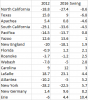
 b) I'm trying for as roughly equal a division by population as possible and adding more counties to SoCal would create an even bigger imbalance and c) I only want to add the votes in 10 counties every time, which is the most time-consuming part of this process.