What font do you use for the map legend?View attachment 526620
The Great Eurasian Revolution:
This is a map of an ATL of my 1914-Timeline (I have several names but haven't decided yet. Current front-runner is "The Springtime Revolution") in which the Entente (France, British Empire, Belgium, Hungary) won WW1 instead of the Allies (Germany, Russia, Bohemia-Galicia, South Slavia, Romania, Afghanistan and Iran (last two very nominally mostly just allowing Russian armies to cross into British India)). This is 20 years after the end of WW1.
Some other things not on this map:
1. Austria-Hungary was partitioned by Russia and Germany in 1914 before WW1. Italy annexed Dalmatia and South Tyrol. Czechia and Galicia-Lodomeria were united under a Romanov monarch, Hungary (Hungary proper and Slovakia) became independent (still under Hapsburgs), Austria proper and Slovenia were annexed into Germany (under Hapsburgs), Romania gained Transylvania while Serbia annexed Bosnia, Vojvodina and Croatia.
Therefore in WW1 (1915-1918) Hungary would join the Entente.
2. In the timeline of this map there was Danubia which fell to communist revolution soon after it was established. It was as established a "weird zombie reverse Austria Hungary", which did not include Galicia and Included Hungary, Austria, Bohemia and Illyria as nominally equal members. As it existed it was Hungarian dominated.
3. Notes 7 and 13 might have been clear enough but I wish to spell it out. The Chinese Provisional Government replaced the Chinese military "governor" warlords with governors who were from Japan, Britain and France who were military officers of their home nations and commanded various expeditionary forces also have basically unlimited authority in their specific province, regarding its governance/administration, combat against communists and raising+commanding of various troops.
4. If it was not clear the blurb below USCR refers to a possible World War 2.
You are using an out of date browser. It may not display this or other websites correctly.
You should upgrade or use an alternative browser.
You should upgrade or use an alternative browser.
Map Thread XIX
- Thread starter water123
- Start date
- Status
- Not open for further replies.
What font do you use for the map legend?
MS Paint, Courier, size 8
Well, this is my very first alternate history map, so here we go:

This is another Central Powers victory in WW1, but with some unique details:
-Spain joined the war the first months of 1919, just in time because the germans were getting exhausted on the frontlines.
-Greece never joined any team, they remained neutral thus the Balkan Front was finished as early as 1916, when Romania and Montenegro surrendered.
-This time the german officials persuaded Afghanistan to join the war, although all they did was cut the british supplies from Raj to Mesopotamia and support Iran against the allied ocupation.
-The Ottomans managed to capture the Suez Canal, and then the germans had the opportunity to get supplies thus they don't have to try a contra-blockade of the UK.
The map corresponds to the year 1920 (nothe that some remnants of the white forces exist in SIberia and south Turkestan); the war finished in summer 1919 and the treaties were signed in late 1919. Because of the anti-colonialist support that the Ottomans gave to african rebels, their Senussi allies get the libyan territory (except urban and coastal areas), the Darfur state is restored and italian colonies are partitioned between native states and Abisynnia.
The British Empire is dismantled: their african colonies get annexed by Germany, the Ottoman vilayets that were occupied by the UK in the late 19th century became ottoman puppets and their arabian protectorates became independent with Ottoman supervision.
The Raj dissolves and some states are created from it, (such as Hynderabad and Kashmir) Nepal, Bhutan, Iran and Afghanistan all get territories from India, the independence of Burma is restored. Then, Malaya was occupied by Germany and North Borneo is awarded to the Netherlands (remember that they had an alliance with the Kaiser); Spain exchanged their Rio Muni colony for the complete protectorate over Morocco and some Mauritanian territory.
The treaty of Brest-Litovsk still ocurres, but with the war lasting longer, both the Allies and CP failed to support the whites and the bolsheviks had nearly win by this point., with the support of the french syndicalists that rose to power after the armistice.
Then, central europe:
Austria-Hungary annexed Veneto but failed to achieve national unity, thus they became a confederation of different states (Austria, Hungary, Bosnia and Galitzia) with the same Royal Family, the one that was put in power too on their new protectorates, Serbia and Romania.
Italy nearly dissolves but the communists along with the syndicalists rose to power in the north, and a coalition of moderates and german-style autoritarian monarchists regained control over Rome and the south.
Bonus: China is still a mess, with the bolsheviks controlling the Manchurian Railways and Japan influencing some warlords.
I'm a beginner so I don't think I got the correct colours, I'm sorry about that
Has @B_Munro ever produced a map tutorial? I’m interested in producing a ‘Munroist’ map. Thank you in advance!
Well, this is my very first alternate history map, so here we go:
This is another Central Powers victory in WW1, but with some unique details:
I'm a beginner so I don't think I got the correct colours, I'm sorry about that
First of all, welcome. Always nice to get some fresh new people on the site.
Second, I don't think anyone cares that much if you use a specific color scheme or not. It can be useful, but it does get kind of repetitive, so it's actually kind of nice to see different colors every once in a while.
Third, and finally, what's going on with all of the former British colonies? India, I'm assuming was forcibly taken away or revolted after seeing the British lose. Is Bangladesh still British, Independent, or a dominion? What's going on with South Africa? Independent? British Influenced? German Influenced? Syndicalist?
Ephraim Ben Raphael
Banned
View attachment 526929
Proposed peace map for Israel-Palestine as part of a Bosnia-esque state. Needless to say, this is never happening and would be unfeasible. I made it in 2017.
Whoa. Ramallah in Israel and Eilat in Palestine? I'm pretty sure that the majority of the Arab population of Israel/Palestine is located in Israel on that map, while at least a third of the population of that Palestine is going to be Jewish. That neutral zone also looks a bit far south to have Jerusalem, but maybe I'm just misjudging it.
Nice little map though, when it comes to the technical side of things!
A very quick scenario I made to rest from finals and warm up to write my other TLs like Pachamama Awakens. Pulled it together on a couple hours from an old abandoned map so don't expect too much.

Unthinkable:
Basically, Wiston Churchill goes ahead with Operation Unthinkable in 1946.
Things go VERY bad for the Allies. Morale drops below the floor as soldiers are asked to fight yet ANOTHER war, this time against their former allies and with Nazis at their side. The logistic train never reaches far beyond Poland, even with all the resources of the US and the British Empire. Not even the power of the atomic bomb was able to stop the Soviet steamroller (not that the Allies could have consistent air superiority anyways), and the waves of deserting soldiers and uncooperative civilians unwilling to fight another war. In fact, the mere proposal of bombing Paris as the Soviets advanced broke down the US-UK alliance, and soon, the United Nations started their long and painful retreat from Europe.
On the other side of the curtain, an enraged Stalin orders the Red Army to "Not to stop until you plant a red flag over Gibraltar Rock".
Only two years later, his words become reality, as partisans of the Iberian People's Republic take over the besieged British garrison.
It is 1955 today. The USSR is the undisputed master of Europe.
While the Red Army also experienced desertion and mutinies, the unwillingless of the Soviets to bear yet ANOTHER Nazi invasion took them all the way to the Atlantic shores, assisted by communist partisans on the way. Eastern Europe was annexed, with only a note of protest from the United Nations. Germany was also annexed and dismantled; Stalin took a cue from Roosvelt and divided it on several states, but as far as the Soviet Union is concerned, Germany no longer exists or will ever exist again as a nation; instead, education there forces the identity of Bavaria, Saxony, Rhineland, Hannover, Brandenburg..., and most importantly, an absolute hate of Fascism, love for peaceful agrarian living, and a sense of duty to the Soviet Union. Or else. The rest of Europe retains a nominal independence, though it's difficult to say that with Red Army garrisons in every capital. The Soviet Union has imposed taxing reparations from most of its conquered territories, and Stalin has consolidated power to a terrifying degree. Relations with the West are completely frozen; as far as Stalin is (or rather, was) concerned, the United Nations are a fascicapitalist alliance plotting for the fall of the USSR. Soviet citizens are taught so, too. The most brutal decisions have been taken with that mentality.
The United Nations almost dissolved after Unthinkable, and just saying the name "Winston Churchill" provokes bar fights everywhere in the Anglosphere. However, at the end they stayed together out of fear of the Soviet juggernaut. The United States, with the largest remaining army and navy, provide most of its military muscle and economic power. UN protectorates have been established on the former colonies of occupied Europe, and it retains bastions in the Mediterranean, much to the lacking Soviet Navy's frustration. In Asia, the USA has cobbled together a United States of Asia from Japan, South Korea, the Philipines and the Republic of China, which retains Hainan. Something of a phyrric victory, of course, and Soviet propagandists are quick to call it a revived Japanese Empire. The USA has a cold alliance with the UK and France. The UK, of course, dropped the ball so hard that US generals see little reason to help them prop their falling empire, beyond the need of cooperation against a common empire. Free France still clings to the fantasy of returning to the mainland, and while the US is more sympathetic towards them, but they can't ignore the fact that their colonial subjects aren't very willing to being governed from a phantom Paris anymore.
The Third World is quickly becoming independent, no matter what the goverments in exile might want. India and the Middle East aren't very friendly to the United Nations, being members only in principle: India has deep sectarian issues, but sees itself as an emerging power, mobilizing its huge population towards industralization. Poor Turkey is stuck in a situation similar to Finland OTL; too hard for the Soviets to conquer, but basically surrounded by them. Israel and Palestine are still dealing with their painful partition. The US looks towards the conservative governments and dictatorships of Latin America for more "reliable allies", but not all are convinced, and Argentina and Brazil wish to persue armed neutrality. The colonies in Africa and Southeast Asia seem to become the next battleground in this Cold War.
Not that the USSR has it any better. It has created one of the largest empires of history, covering countless nationalities, in just a few short years, and has kept it together by force of arms, repression, and political indoctrination. From uprisings in Iran to tensions in Korea to unruly European allies and of course the big Panda Bear in the room that is China, something is gotta give one of these days...
And just a few hours ago, Stalin was pronounced dead...
Last edited:
Here's the world from Code Geass, as described at the very start of the series. Spurred on by Japan's refusal to capitulate to the demands of the Holy Britannian Empire's desire for the precious material Sakuradite, heavily strained diplomatic tensions eventually gave way and lead to a declaration of war on August 10, 2010 ATB. While Europia United and the Chinese Federation protested the invasion, there was little they could do to intervene. Britannian forces introduced into combat the autonomous armored robotic knights, known as Knightmare Frames, which obliterated Japanese forces on the mainland with little effort.
Japan fell in less than a month and became a dominion of the empire. The country was stripped of its freedom, rights, culture, dignity, and even its name- renamed Area 11, marking another conquest by Britannia.
(2010 in A.T.B. would actually be 1955 A.D.)
Last edited:
Man, I really think the British took decolonization too seriously ITTL.View attachment 526999
This is something I did back in 2016(?) or so for a Civilization V custom civ. I was never really that good, but I'd like to share this (even though it isn't that alternate) as I'm pretty proud of it, and I didn't know where to post it.
How come the Soviets ignored walking into South Korea, the US had little troops there.
Technically not alternate history but I'll move back onto doing that, just experiementing with styles. Been a while since I last posted a map. During this time, I've been learning QGIS and Blender to create better maps. Let me know if you have any feedback!
____________________________________________________________________________________________________
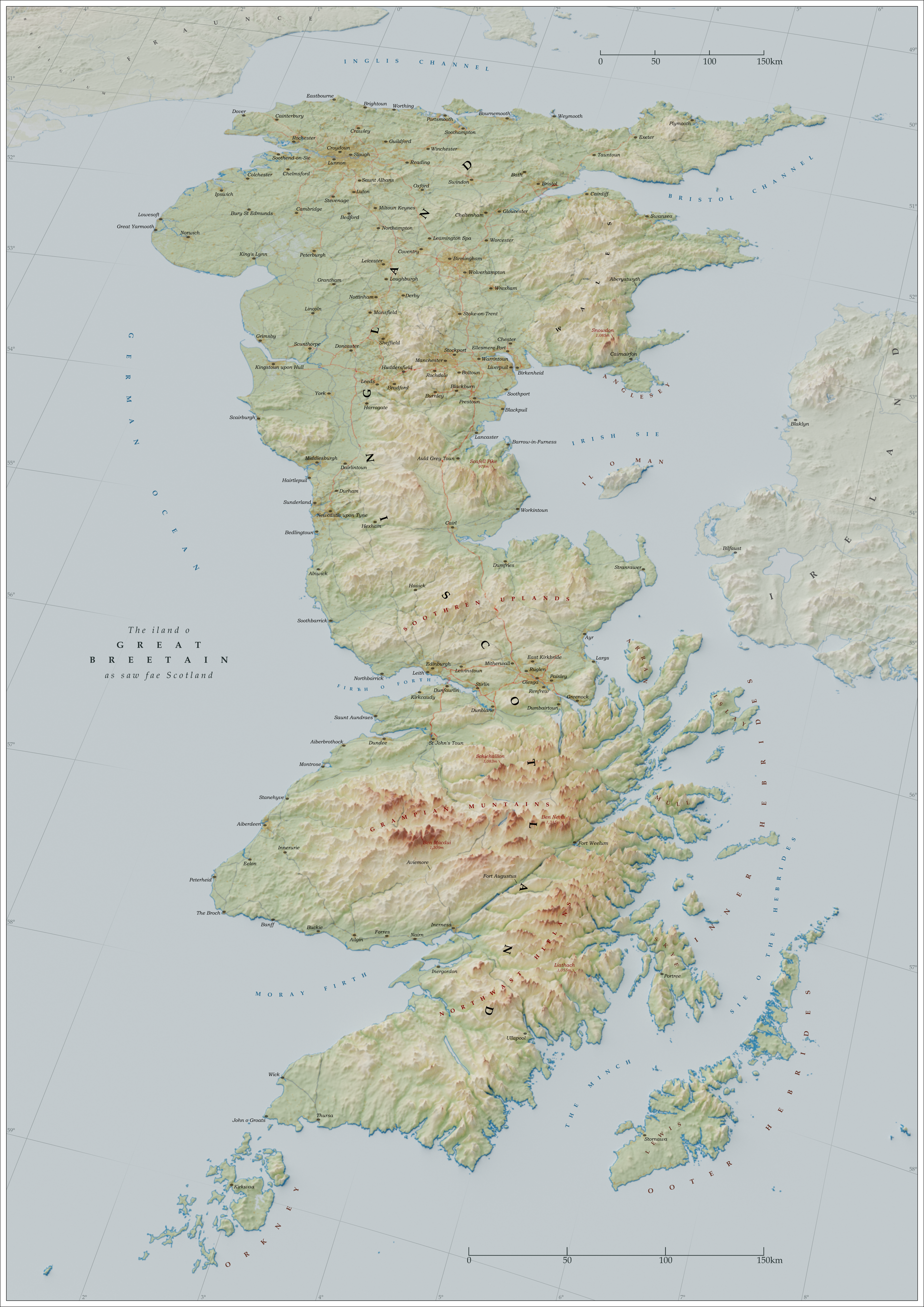
This map’s purpose is to provide a Scottish perspective of the isle of Great Britain. This is achieved through the use of Scots language, a south-east orientation, and a perspective at an angle of 35°.
Method…
1. Generating TIFF
a. Download relief data and merge into one file covering area.
b. Reproject TIFF and clip by extent.
c. Resample TIFF to a lower resolution to avoid noise when rendering.
d. Rescale TIFF to a much greater scale to avoid terracing.
i. Formula: “ReSampled TIFF” / 1250 x 65535
e. Translate TIFF to Unt16.
2. Generate High Resolution Base Image.
3. Import Base Image as the base colour of a plane and Translated TIFF into Blender with its colour corresponding to the displacement height of the plane’s material output (Midlevel 0.5 and Scale 0.1).
a. Angle camera at 35° for perspective.
4. Import rendered image into Inkscape to label.
5. Export as final image.
Shaded relief from…
Jarvis A., H.I. Reuter, A. Nelson, E. Guevara, 2008, Hole-filled seamless SRTM data V4, International Centre for Tropical Agriculture (CIAT), available from srtm.csi.cgiar.org.
British coastline, Roads and motorways from…
Ordnance Survey Strategi: Contains OS data © Crown copyright and database right 2018, available from www.ordnancesurvey.co.uk/busin…
Major rivers and inland water from…
Made with Natural Earth. Free vector and raster map data, available from www.naturalearthdata.com/downl…
Other coastlines from…
GADM v3.6 © 2018 GADM, available from gadm.org/data.html
If it has one, a town in Britain will use its Scots placename. If not, it will be Scots-icised through this process…
· Placenames with the suffix ‘-ton’ changed to ‘-toun.’
· Placenames with the suffix ‘-pool’ changed to ‘-puil.’
· Placenames with the suffix ‘-ing’ changed to ‘-in.’
· Placenames with the suffix ‘-brough’ or ‘-borough’ changed to ‘-burgh.’
· Placenames with the ‘ar’ sound (i.e. Carlisle, Scarborough) changed to an ‘air’ sound.
· Placenames with the ‘ou’ sound (i.e. Plymouth, Portsmouth) changed to an ‘oo’ sound.
…going with the theme of the map of inversing the process of Anglicisation done in cartography by Scots-icising English placenames just as England-orientated maps Anglicise Scottish placenames. (All placenames in Scotland use their Scots placenames.)
Awesome map, it vaguely reminds me of my "The Pale Continent" map because of the south-up map orientation - but your map looks so much better!
During Cornelia's first appearance at the beginning of the series she fights in a desert region resembling the Middle East and talks about "the end of the government of area 13" (I'm not sure of the number of the area). Where do you place this area?View attachment 527011
Here's the world from Code Geass, as described at the very start of the series. Spurred on by Japan's refusal to capitulate to the demands of the Holy Britannian Empire's desire for the precious material Sakuradite, heavily strained diplomatic tensions eventually gave way and lead to a declaration of war on August 10, 2010 ATB. While Europia United and the Chinese Federation protested the invasion, there was little they could do to intervene. Britannian forces introduced into combat the autonomous armored robotic knights, known as Knightmare Frames, which obliterated Japanese forces on the mainland with little effort.
Japan fell in less than a month and became a dominion of the empire. The country was stripped of its freedom, rights, culture, dignity, and even its name- renamed Area 11, marking another conquest by Britannia.
(2010 in A.T.B. would actually be 1955 A.D.)
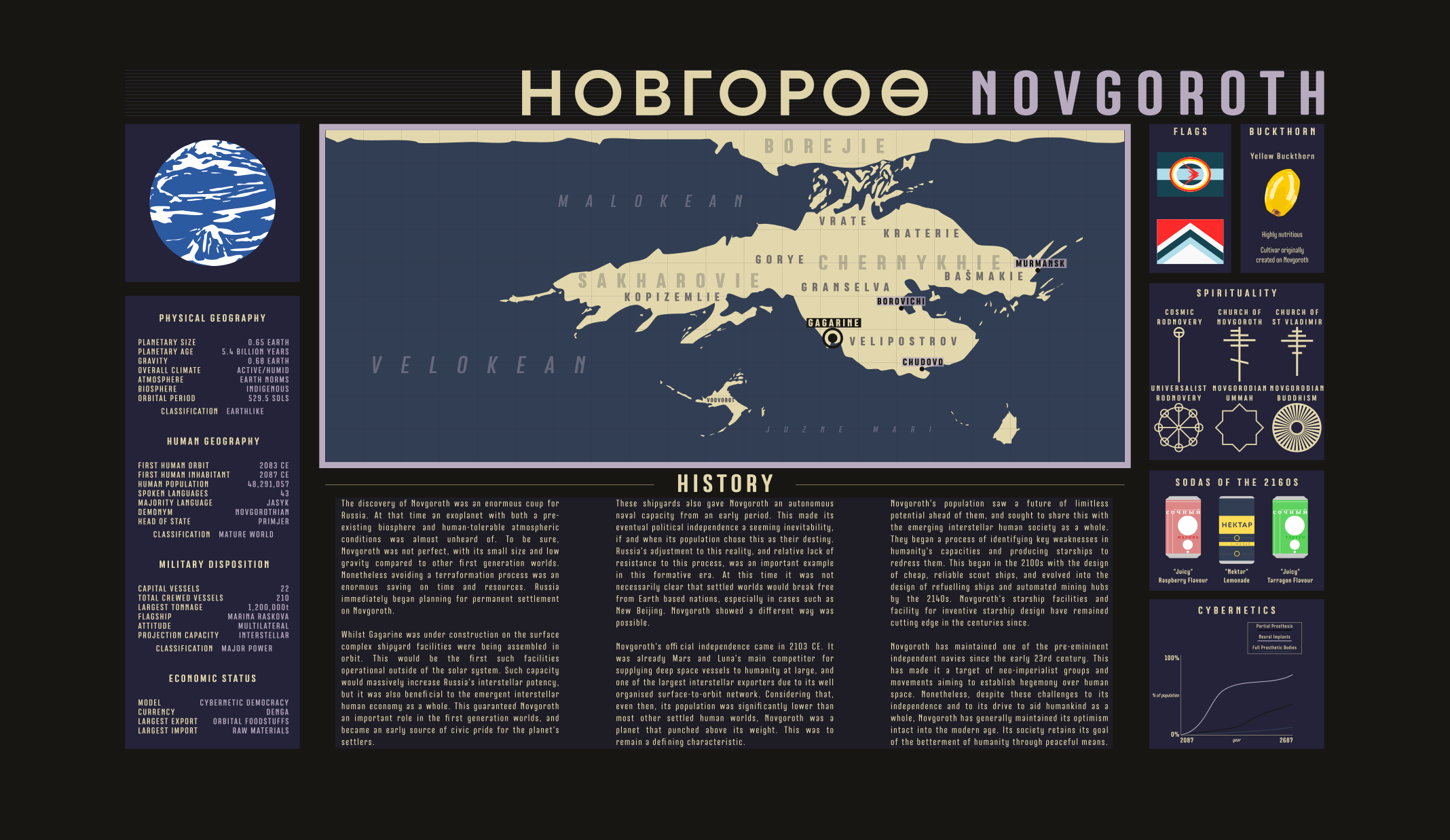
It's that Crumpleverse time once again. This time starring our friend Novgoroth, a Russian-founded first generation world. Deviantart link for those in need.
The Megali Idea looks a lot like what happened to Czechoslovakia in 1938.
The Megali Idea looks a lot like what happened to Czechoslovakia in 1938.
This is what happens when one group lives along the edges, and the other group lives in the interior. It's much, much more complicated than that, though.
I know, because even back then it was highly unlikely there were more Greeks than Turks in such a large chunk of Anatolia. At least as far language, religion and customs are concerned, genetically Greece would only start tapering off near the Kurd border.This is what happens when one group lives along the edges, and the other group lives in the interior. It's much, much more complicated than that, though.
View attachment 527073
Since a lot of y'all like to split up Turkey in your timelines (and in light of recent events in Syria), I decided to make this handy chart/guide for anyone who it could be useful for.
Honesty, Turkey is lucky beyond luck it survived in it current state given almost everyone long before, and after wanted to tear it apart. (The only reason why the Ottoman Empire survive into the 20th century was because none of the Great Powers could not agree to who gets what in such a dismantlement. If they had, and carried it out, the Ottomans and in turn, the Turks, would have been history at any point after the Napoleonic Wars.)
Last edited:
- Status
- Not open for further replies.
Share: