A similar thing to yesterday's post, this one is the Lieutenant Governor primary as an election between the two parties by county (although the votes for Dominique Block in the Republican primary are omitted because the source for the data I found didn't tell me them, and since that only means cutting 20,262 votes it doesn't change the outcome). This would be a Republican victory with 52.21% of the vote to 47.79% for the Democrats.

You are using an out of date browser. It may not display this or other websites correctly.
You should upgrade or use an alternative browser.
You should upgrade or use an alternative browser.
Alternate Electoral Maps III
- Thread starter killertahu22
- Start date
A similar thing to yesterday's post, this one is the Lieutenant Governor primary as an election between the two parties by county (although the votes for Dominique Block in the Republican primary are omitted because the source for the data I found didn't tell me them, and since that only means cutting 20,262 votes it doesn't change the outcome). This would be a Republican victory with 52.21% of the vote to 47.79% for the Democrats.
View attachment 498093
Bizarre to see a Democrat doing that well in Little Dixie + winning Oklahoma County and still losing statewide by a clear margin.
The Confederal Assembly holds elections every six years. The most recent election occurred in 2016, and the results were as follows:
Governing Coalition: (322/500)
- Liberal Alliance for Prosperity: 231
- United Workers Front: 87
- Pan-Realm Centralist Movement: 4
Opposition Groups: (178/500)
- Coalition for the Advancement of Liberty: 95
- Confederalist Coalition: 53
- Socialist Popular Front: 17
- Native American Front: 8
- Pan-Green Alliance: 4
- Democracy Now!: 1
As a reminder, these don't represent singular parties, but rather coalitions at the Confederal level of likeminded individuals. The Confederalist Coalition's members have varying ideological positions and are simply united in their support of realmism (nationalism for their respective realm) and a weak confederal government. This means members of the Confederalist Coalition often vote very different on matters outside of expanding or limiting the confederal government.- Liberal Alliance for Prosperity: 231
- United Workers Front: 87
- Pan-Realm Centralist Movement: 4
Opposition Groups: (178/500)
- Coalition for the Advancement of Liberty: 95
- Confederalist Coalition: 53
- Socialist Popular Front: 17
- Native American Front: 8
- Pan-Green Alliance: 4
- Democracy Now!: 1
Last edited:
All people fictional
2004

Governor Henry Lasalle (D-LA)/Attorney General Audrey Silva (D-NY) 276 EVS, 41.22%
Senator Patrick Sheehan (R-IL)/Representative Harry Zheng (R-CA) 254 EVS, 42.98%
Governor Ronald Heiffer (CDUSA-UT)/State Senator Johanna Milligan (CDUSA-ID) 5 EVS, 2.01%
Mayor Hank Wharton (G-MO)/State Representative Harriet Hammond (G-AK) 3 EVS, 8.23%
Televangelist Xavier Carris (C-PA)/Former Representative Daniel Swoon (D-AL) 0 EVS, 3.10%
Former State Treasurer Eli Karakoff (P-NY)/Maria Shawdelle (P-MA) 0 EVS, 1.20%
Superintendent Rufus Jackobee (I-NY)/Songwriter Melliane Molloe (I-GA) 0 EVS, 1.12%
Others 0 EVS, 0.14%
2004
Governor Henry Lasalle (D-LA)/Attorney General Audrey Silva (D-NY) 276 EVS, 41.22%
Senator Patrick Sheehan (R-IL)/Representative Harry Zheng (R-CA) 254 EVS, 42.98%
Governor Ronald Heiffer (CDUSA-UT)/State Senator Johanna Milligan (CDUSA-ID) 5 EVS, 2.01%
Mayor Hank Wharton (G-MO)/State Representative Harriet Hammond (G-AK) 3 EVS, 8.23%
Televangelist Xavier Carris (C-PA)/Former Representative Daniel Swoon (D-AL) 0 EVS, 3.10%
Former State Treasurer Eli Karakoff (P-NY)/Maria Shawdelle (P-MA) 0 EVS, 1.20%
Superintendent Rufus Jackobee (I-NY)/Songwriter Melliane Molloe (I-GA) 0 EVS, 1.12%
Others 0 EVS, 0.14%
Map of the States, Republics, Territories, and the Distrito Federal During the last governor elections (Territories, Except for the Seward Joint Protection Zone, are directly ruled from Pittsburg)
Republican Unity Party - Your standard conservative party, you know, except for the mildly racist parts. The main platform is Mandatory Military service, and more expansion to combat the "Canadian Liberation Force" (A terrorist organization that's in control of most of the prairies, and the red river area)
Democratic-Green Party - Wants to improve Nature rights, whatever's left at least, and to find a solution for the major flood (all parties want this, but the DG's want this the most)
Libertarian-Worker's Union - A mainly Farmer based party, they want a form of socio-capitalism, where the workers control the factories, but they elect a manager to do the finances. Surprisingly, they actually get most of their goals done, which is why they're the fastest growing party.
Independent - Missouri and Chicagoland requires that their governors be independent, as they see the fall of the usa (and some fringe politicians also see the flood as caused by) caused by Political Parties, although their congresses can be whatever party.
What's the backstory?View attachment 500049
Map of the States, Republics, Territories, and the Distrito Federal During the last governor elections (Territories, Except for the Seward Joint Protection Zone, are directly ruled from Pittsburg)
Republican Unity Party - Your standard conservative party, you know, except for the mildly racist parts. The main platform is Mandatory Military service, and more expansion to combat the "Canadian Liberation Force" (A terrorist organization that's in control of most of the prairies, and the red river area)
Democratic-Green Party - Wants to improve Nature rights, whatever's left at least, and to find a solution for the major flood (all parties want this, but the DG's want this the most)
Libertarian-Worker's Union - A mainly Farmer based party, they want a form of socio-capitalism, where the workers control the factories, but they elect a manager to do the finances. Surprisingly, they actually get most of their goals done, which is why they're the fastest growing party.
Independent - Missouri and Chicagoland requires that their governors be independent, as they see the fall of the usa (and some fringe politicians also see the flood as caused by) caused by Political Parties, although their congresses can be whatever party.
Currently, there's none, except for that there's was a giant flood.What's the backstory?

The final results of the 2016 United States Senate election in Balboa. Senator John McCain, a native Zonian and key advocate for Canal Zone (and later Balboan) statehood, would be reelected by a margin of nearly 2 thirds over Colon Mayor Federico Policani.
However, despite a resounding defeat, Policani would come back two years later to win the 2018 Special Election held after Senator McCain's death in January of that year due to brain cancer.
It does unless it's very, very different. So it can't involve any relevant OTL figures.Does anyone know if alternate 2016 elections count as current politics at this point?
It's still the most recent U.S. presidential election, so yesDoes anyone know if alternate 2016 elections count as current politics at this point?
I got bored and decided to make a sort-of proportional UK election map.

Similar to the German Zweitsimme in some ways,* the regional constituencies of the UK are a new part of elections introduced for the 2015 election, created at the behest of the Liberal Democrats for their participation in the coalition government and as a counterbalance to the reduction in seats of the boundary review conducted at the behest of the Tories. They are used to elect an additional 115 MPs to the House of Commons, assigned at a rate of roughly 1 member per 500,000 residents, with members basically added by rounding up or down. Also like the Zweitsimme, votes are cast at the same time as the regular vote for one's House of Commons constituency, with roughly proportional vote-to-seat calculations.
In their inaugural election, it was not the Lib Dems who most benefitted as one might expect, but UKIP, who won 16 of their 17 seats in Parliament through the regional constituencies. However, the Lib Dems did manage to win twice as many seats due to the regional seats, and the Greens won three additional seats to the Brighton seat they held. Despite the Tories winning over 100 FPTP seats more than Labour, they tied with Labour in the regional constituency members, although they still won 370 seats, enough for an overall majority.
*This has nothing to do with anything, but I find it amusing how much Farage would probably hate that he has to switch to a system inspired by Germany to make much leeway in Parliament.
Last edited:
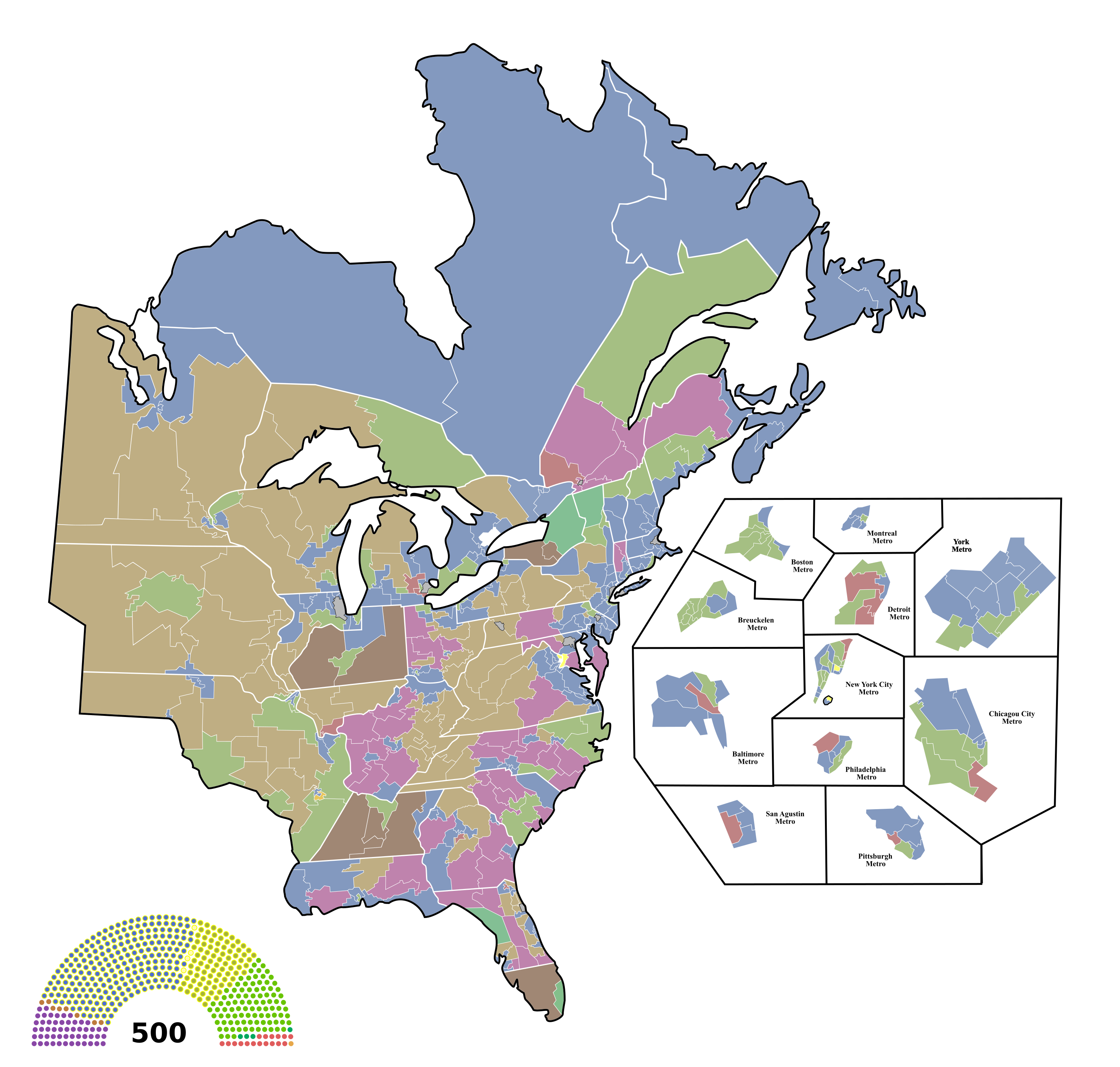
Here's a map of New England with Canadian parties and apportionment based on 2010 census data, I tried my best to combine Canadian and New England voting patterns but I'm no expert on Canadian political geography, so there might be some errors. If New England was in Canada. it would have a heavy influence on the country and Parliament. The population would jump by nearly fifteen million, and assuming the House of Commons simply absorbs all of the seats in this New England map, it would balloon in size from 338 MPs to 468.
Here's a map of the same 'nation' as my other electoral map, just after another asb put them onto (and the rest of the world, minus chaos and unsettled zones) an alt 2019 (much like our own, minus some changes) Alaska, Deseret, and Sonora have large minorities in the voting process, much more than the other states. New Connecticut is CN, in order to differentiate between North Carolina, which both it and SC are in the process of leaving the union (let's see how this turns out), as the provisional state of Carolina (formed from the former Appalachian Republic's land in the Carolinas) refuse to remove itself from voting, which the other 'free' states (Dixie, Florida, Delaware, and New Jersey) are supporting NC and SC with.


Nazi Space Spy
Banned
Are you thinking of doing more American states as part of ATL Canada?View attachment 501582
Here's a map of New England with Canadian parties and apportionment based on 2010 census data, I tried my best to combine Canadian and New England voting patterns but I'm no expert on Canadian political geography, so there might be some errors. If New England was in Canada. it would have a heavy influence on the country and Parliament. The population would jump by nearly fifteen million, and assuming the House of Commons simply absorbs all of the seats in this New England map, it would balloon in size from 338 MPs to 468.
You should do the reverse, with canada only having like 4 parties (republican, democrat, green, and independent)View attachment 501582
Here's a map of New England with Canadian parties and apportionment based on 2010 census data, I tried my best to combine Canadian and New England voting patterns but I'm no expert on Canadian political geography, so there might be some errors. If New England was in Canada. it would have a heavy influence on the country and Parliament. The population would jump by nearly fifteen million, and assuming the House of Commons simply absorbs all of the seats in this New England map, it would balloon in size from 338 MPs to 468.
Last edited:
2000 election if the Lewinsky Scandal have never broke:
Helpful hint: Use the Snipping tool if you're posting your images in this way. You'll avoid the extra unneeded clutter around your image.
.
Share: