You are using an out of date browser. It may not display this or other websites correctly.
You should upgrade or use an alternative browser.
You should upgrade or use an alternative browser.
The Q-BAM Improvement and Core Thread
- Thread starter iori
- Start date
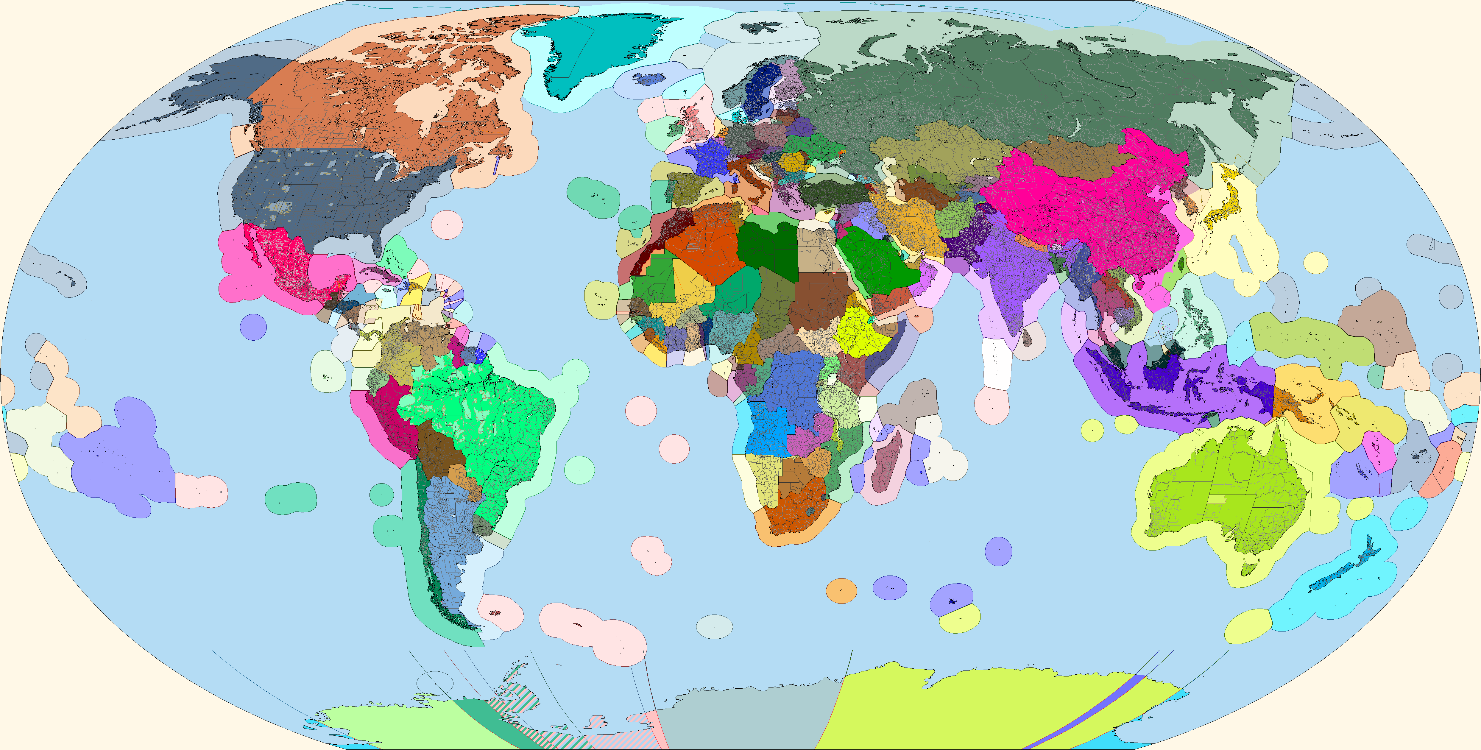
It seems Turkmenistan invaded Uzbekistan.Fin. Do note that Peter I Island, the western Hawaiian Islands, Wake Island, and the Balleny Islands were in the wrong place and were thus moved in this map.
And indeed so. That territory is the Surxondaryo Region of Uzbekistan.It seems Turkmenistan invaded Uzbekistan.
Uzbekistan: I cannot into sea, can give access to the Amu Darya?
Neneveh!Turkmenistan: No
Fin. Do note that Peter I Island, the western Hawaiian Islands, Wake Island, and the Balleny Islands were in the wrong place and were thus moved in this map.
Wow ! I really thank you because this world map with EEZ is wonderful !
It seems Turkmenistan invaded Uzbekistan.
Oops! Well, I'll fix that later this evening, but if it's my only major mistake, then I'm happy. Thanks for pointing that out. I do know that at least one area still needs more work: Turkey's claims in the Mediterranean.
Kafia Kingi is de facto South Sudan, and Blue Nile state in Sudan should be BrownFin. Do note that Peter I Island, the western Hawaiian Islands, Wake Island, and the Balleny Islands were in the wrong place and were thus moved in this map.

EDIT: Fixed the Turkmen-Uzbek border snafu.
Are we going to add de facto controlled boundaries onto the wham? There were for a few of them but idk if people want to bring that back
Kafia Kingi is de facto South Sudan, and Blue Nile state in Sudan should be Brown
One, Kafia Kingi, and in fact that whole southwestern chunk of disputed land, is controlled and claimed by Sudan but internationally recognized as part of South Sudan. Two, I am using the X2/3 color scheme.
I'm referring that Kafia should be South sudan's colour and that state of Sudan should be Sudan's colourOne, Kafia Kingi, and in fact that whole southwestern chunk of disputed land, is controlled and claimed by Sudan but internationally recognized as part of South Sudan. Two, I am using the X2/3 color scheme.
I'm referring that Kafia should be South sudan's colour and that state of Sudan should be Sudan's colour
South Sudan does not control Kafia Kingi. Sudan does. Whomever controls a territory is given primacy over disputes. So this region remains Sudan's color, which on the X2/3 is RGB 135-80-49.
What about the Blue Nile state of Sudan then?South Sudan does not control Kafia Kingi. Sudan does. Whomever controls a territory is given primacy over disputes. So this region remains Sudan's color, which on the X2/3 is RGB 135-80-49.
What about the Blue Nile state of Sudan then?
Ah, okay. I see what you mean now. You gotta explain things like that a bit better. If you say "Blue Nile state is wrong color" what I think is that there is supposed to a country along the Blue Nile, or that Sudan or South Sudan is another color on a different color scheme.
Hey, could someone kindly make a map of Europe and northern Africa in 1796 using the SUCK color key? I'm currently making an election game starting in 1796, and I need an in-depth map of Europe at the time (roughly January 1, 1796). I'd greatly appreciate it!
You might want to request this in the “QBAM Historical Map Thread” - this one is largely for developing the basemap itself and modern borders/subdivisions
Erm, I believe Canada might need some extra working to do, particularly along the Prairies:
https://upload.wikimedia.org/wikipedia/commons/7/72/Alberta's_Municipal_Districts.png (https://upload.wikimedia.org/wikipedia/commons/8/8f/Alberta_municipal_districts.png)
https://upload.wikimedia.org/wikipedia/commons/5/57/Saskatchewan_Rural_Municipalities.png
https://upload.wikimedia.org/wikipedia/commons/c/ca/Manitoba_municipalities_2015.png
Of these, Alberta seems readily doable, and is completed in the case of Census Divisions 15, 16, and 19.
Saskatchewan and Manitoba are about as difficult as Norway.
Also, perhaps we could draw the Whitehorse Census Subdivision of Yukon (that big territory in the southern part of the map)?
http://www.sewp.gov.yk.ca/dbimg?imageid=164
Last edited:
I don’t think anyone has touched Antarctica besides glaciers. It probably is capable of being added.Has anyone touched on Antarctica in recent? Also, I was thinking about some past QBAM maps that featured ocean floor topography, and I'm wondering if that is compatible with the current version.
The current version doesn't have rivers, unfortunately. You have to draw on your own. Alternatively, you can ask the historical maps thread.Sorry to ask this dumb question, but I don't have the time to search through this thread. Does anyone know if there's a QBam map with the Arno and Rubicon rivers on it? I'm pretty sure I saw it once before.
Share: