How long did this map take to make?BIG map time
I posted this map on r/IM like three hours ago and it only has twenty upvotes, so now I'm posting it here too in the hopes that it'll get some more of the attention that I desperately crave.
This map is a remake of an old map I made about a year and a half ago. The main point of divergence is the Romans winning the Battle of Yarmouk and killing Khalid ibn al-Walid, resulting in the Caliphate expanding eastward and Persia being split between an islamic part south of the Zagros Range and the Byzantines conquering, converting, and quickly loosing control of the part north of the Zagros. Islam then spreads through India to China (Serica).
Another sub-PoD is Otto II conquering half of West Francia, creating a much bigger and badder Empire of the Germans. Fun ensues.
Also I accidentally made the Incas way bigger than they should be. This map was initially meant to depict 1500 AD, but I changed it midway through to be 1300 AD in stead, so there might be a few mistakes that seem like they shouldn't be on a map this early. That's why.
You are using an out of date browser. It may not display this or other websites correctly.
You should upgrade or use an alternative browser.
You should upgrade or use an alternative browser.
Map Thread XIX
- Thread starter water123
- Start date
- Status
- Not open for further replies.
Goddamn I love everything about this, i really love all multicultural Alaska, and I love this flag.
What’s the history of the name of order fifteen city?
Field Order 15 is the field order where General Sherman granted land to freedmen in Southern Georgia '40 acres and a mule'. There was pushback after the US Civil War, but with radical Republicans in the White House and Congress, Reconstruction was significantly better funded. Southern Georgia for instance saw construction of significantly more black institutions like colleges and churches. Order Fifteen City was started by what we would call an HBC trying animal husbandry in the colder climate, which quickly blossomed into a major regional capital as fisheries and gold began to be exploited. It gained the name as a nod to both the University's founding thanks to the Field Order, and to its agricultural history (mules are a common symbol for the city, their sports mascots, etc.).
Last edited:
I had a random thought. IOTL, Germany lost a lot of land to Poland after WW2. What if instead it lost land to a different country?
Here's one possibility.
The Allied powers, faced with a dire situation following the Soviet Union's collapse in 1943, successfully persuaded the Italian government to switch sides in the war, in return for Italy being promised a large amount of German territory up to the Danube (i.e. the old northern boundary of the Roman Empire).
Note that ITTL, the Allies didn't treat Austria as an occupied country, instead just treating it as another part of Nazi Germany. However, following the war East Prussia is made its own country (known as simply "Prussia") and forbidden to reunite with Germany, in a similar role to OTL Austria.
How long did this map take to make?
I've been working on since like July. To be fair, I work very slowly and sporadically.
Idk if it's the colors, the borders, or both, but this looks very natural and it's very pleasing to look at. Good work!BIG map time
I posted this map on r/IM like three hours ago and it only has twenty upvotes, so now I'm posting it here too in the hopes that it'll get some more of the attention that I desperately crave.
This map is a remake of an old map I made about a year and a half ago. The main point of divergence is the Romans winning the Battle of Yarmouk and killing Khalid ibn al-Walid, resulting in the Caliphate expanding eastward and Persia being split between an islamic part south of the Zagros Range and the Byzantines conquering, converting, and quickly loosing control of the part north of the Zagros. Islam then spreads through India to China (Serica).
Another sub-PoD is Otto II conquering half of West Francia, creating a much bigger and badder Empire of the Germans. Fun ensues.
Also I accidentally made the Incas way bigger than they should be. This map was initially meant to depict 1500 AD, but I changed it midway through to be 1300 AD in stead, so there might be a few mistakes that seem like they shouldn't be on a map this early. That's why.
I can actually imagine hanging this on my bedroom wall. Love it.BIG map time
I posted this map on r/IM like three hours ago and it only has twenty upvotes, so now I'm posting it here too in the hopes that it'll get some more of the attention that I desperately crave.
This map is a remake of an old map I made about a year and a half ago. The main point of divergence is the Romans winning the Battle of Yarmouk and killing Khalid ibn al-Walid, resulting in the Caliphate expanding eastward and Persia being split between an islamic part south of the Zagros Range and the Byzantines conquering, converting, and quickly loosing control of the part north of the Zagros. Islam then spreads through India to China (Serica).
Another sub-PoD is Otto II conquering half of West Francia, creating a much bigger and badder Empire of the Germans. Fun ensues.
Also I accidentally made the Incas way bigger than they should be. This map was initially meant to depict 1500 AD, but I changed it midway through to be 1300 AD in stead, so there might be a few mistakes that seem like they shouldn't be on a map this early. That's why.
This here is the Triumvirate, the resident empire and main setting of a sci-fi story I've been planning out.
The gist of it is that the Triumvirate is a confederation between three principal planets; Earth(the blue dot), Kal Doneer(the orange dot), and Shuknaj(the green dot). The dominate species of Kal Doneer are the Sho jef, bird people accustomed to warm and wet climates. The dominate species of Shuknaj are the Delkaji, reptile people accustomed to hot and dry climates.
The capital city is located on the world of Capite Magno(the yellow dot), and the Triumvirate's calendar is based of it's orbit; 433 days divided into 16 months with 27 days each, and the day of the Triumvirate's founding set aside from the other months as a holiday, and a leap year occurs every 8 years.
The Triumvirate's attitude towards other species is similar to the attitude of imperial Europeans to the indigenous peoples of the colonies; they are second class citizens with not as many political or economic freedoms as the three ruling species.
I think this is the first time that I've seen the galactic basemap actually be used and turn out looking nice--good job!View attachment 491665
This here is the Triumvirate, the resident empire and main setting of a sci-fi story I've been planning out.
The gist of it is that the Triumvirate is a confederation between three principal planets; Earth(the blue dot), Kal Doneer(the orange dot), and Shuknaj(the green dot). The dominate species of Kal Doneer are the Sho jef, bird people accustomed to warm and wet climates. The dominate species of Shuknaj are the Delkaji, reptile people accustomed to hot and dry climates.
The capital city is located on the world of Capite Magno(the yellow dot), and the Triumvirate's calendar is based of it's orbit; 433 days divided into 16 months with 27 days each, and the day of the Triumvirate's founding set aside from the other months as a holiday, and a leap year occurs every 8 years.
The Triumvirate's attitude towards other species is similar to the attitude of imperial Europeans to the indigenous peoples of the colonies; they are second class citizens with not as many political or economic freedoms as the three ruling species.
Why thank you.I think this is the first time that I've seen the galactic basemap actually be used and turn out looking nice--good job!
*Squeals for Islamic China.BIG map time
I posted this map on r/IM like three hours ago and it only has twenty upvotes, so now I'm posting it here too in the hopes that it'll get some more of the attention that I desperately crave.
This map is a remake of an old map I made about a year and a half ago. The main point of divergence is the Romans winning the Battle of Yarmouk and killing Khalid ibn al-Walid, resulting in the Caliphate expanding eastward and Persia being split between an islamic part south of the Zagros Range and the Byzantines conquering, converting, and quickly loosing control of the part north of the Zagros. Islam then spreads through India to China (Serica).
Another sub-PoD is Otto II conquering half of West Francia, creating a much bigger and badder Empire of the Germans. Fun ensues.
Also I accidentally made the Incas way bigger than they should be. This map was initially meant to depict 1500 AD, but I changed it midway through to be 1300 AD in stead, so there might be a few mistakes that seem like they shouldn't be on a map this early. That's why.
Omg 83 likes! Has anyone gotten higher?The Hundred Kingdoms: An Alternate Britain
"While the British Isles are home to seven kingdoms that have survived into the modern day as sovereign nation-states, when that number is added to that of the counties and provinces that were traditionally kingdoms in ancient times the sum total of “kingdoms” in the isles reaches nearly fifty. Add the number of ancient kingdoms that have since faded into history to that number and it is easy to forgive the famously proud inhabitants of these isles for their poetic license in rounding up and nicknaming their homelands the ‘Hundred Kingdoms’...”
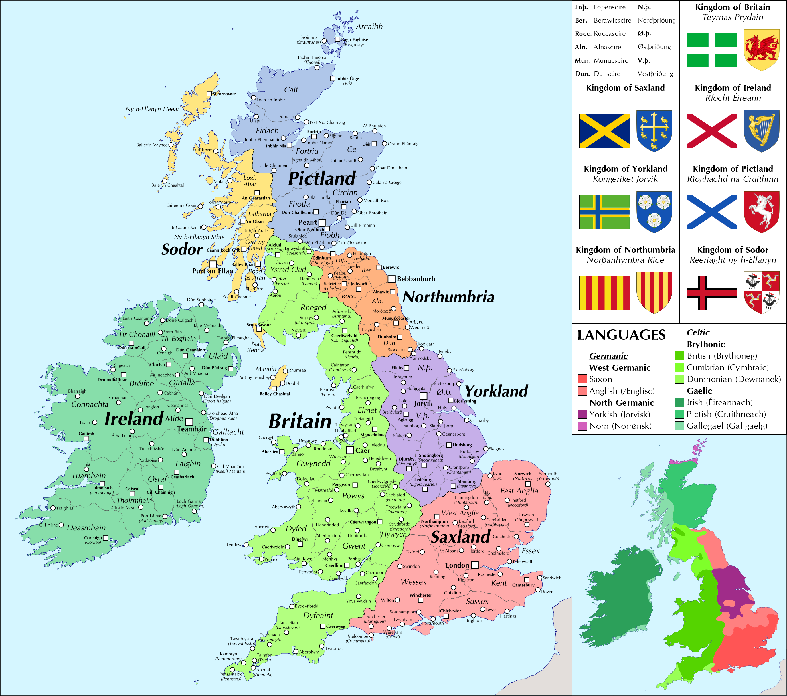
I've seen a number of maps with similar Dark Ages Britain themes lately so I was inspired to try my own hand at it.
Native Britons do a better job of holding their own against the Saxons and are eventually able to turn the tides and gain some lands back, then eventually unite to become the strongest power in the isles. Vikings are more successful at establishing themselves in York as well as in the Isles and Ireland (where they start speaking Gaelic as in OTL but still remain a distinct ethnic group). The Picts become Gaelicized as in OTL but don't merge with Dal Riata due to the stronger Norse in Sudreyjar and so maintain a Pictish identity rather than forming a new identity of Alba/Scotland.
The Angles and Saxons are united politically but still distinct ethnic groups with different languages, the Saxons being more French-influenced and looking across the Channel at least as often as they do to their closer neighbors while the Angles maintain a heavier Germanic influence due to being under Viking rule for considerably longer; Anglish minorities also exist in the Five Boroughs in Yorkland and Hwicce in Britain and there is a movement for unification and independence (Northumbria also speaks Anglish, but Northumbrians have come to be considered a distinct people from the southern Angles). Similar linguistic nationalist movements are also emerging in Britain for speakers of Cumbrian and Dumnonian, which for much of history were dismissed as merely dialects of British but are now enjoying a renaissance. The Norn speakers and erstwhile Norwegian subjects of Orkney likewise feel more kinship to their cousins still under Norwegian rule in the Shetlands and Faroes than they do to their fellow Pictish subjects.
Saxland and Yorkland follow the Catholic Church of Rome, while the Celtic nations plus Northumbria follow the Celtic Church of Iona, which in addition to having a distinct hierarchy headed by the Patriarch of Iona rather than the Pope also follows different customs such as observing the Celtic Rite, dating Easter differently, and placing a greater emphasis on monasticism, though actual theological differences are minor. Small pockets of both Celtic and Germanic paganism (including hybrid forms) still persist in some remote islands and mountain valleys, especially in the north.
Saxon = Modern English
Anglish = Old English
Yorkish = somewhere between Old Norse and Modern Danish
Norn = somewhere between Old Norse and Modern Norwegian
British = Modern Welsh
Cumbrian = Old Welsh / Common Brittonic
Dumnonian = Cornish
Pictish = Scottish Gaelic
Gallogael = Manx Gaelic
IcyCaspian
Banned
I really wish there was an easy way to check this, but I have school tomorrow, so i only checked the one I posted in this thread and it's at 73. So I can say that you are probably in the top 10 at least.Omg 83 likes! Has anyone gotten higher?
Edit: no https://www.alternatehistory.com/forum/threads/map-thread-xix.470444/page-98#post-19427973
Send me the template please, also maybe a Pygmy compilation would work out. As I said before, I'm officially announcing a project to do a 12 States compilation for every officially recognized country with more than 2 million people in reverse alphabetical order. Then maybe I could go to stateless cultures...
That's over 1500 maps! And I thought _my_ project was overly ambitious...

Omg 83 likes! Has anyone gotten higher?
83 is quite a lot, but I've definitely seen some reach into the hundreds. The People's Socialist Atlas is the most liked post I can recall, sitting at 162 likes.
Used to be thing where people listed the most liked of the previous thread when a new thread opened, as a sort of 'best of', but it was quite a lot of effort to trawl through all 500 pages.
View attachment 491665
This here is the Triumvirate, the resident empire and main setting of a sci-fi story I've been planning out.
The gist of it is that the Triumvirate is a confederation between three principal planets; Earth(the blue dot), Kal Doneer(the orange dot), and Shuknaj(the green dot). The dominate species of Kal Doneer are the Sho jef, bird people accustomed to warm and wet climates. The dominate species of Shuknaj are the Delkaji, reptile people accustomed to hot and dry climates.
The capital city is located on the world of Capite Magno(the yellow dot), and the Triumvirate's calendar is based of it's orbit; 433 days divided into 16 months with 27 days each, and the day of the Triumvirate's founding set aside from the other months as a holiday, and a leap year occurs every 8 years.
The Triumvirate's attitude towards other species is similar to the attitude of imperial Europeans to the indigenous peoples of the colonies; they are second class citizens with not as many political or economic freedoms as the three ruling species.
I think this is the first time that I've seen the galactic basemap actually be used and turn out looking nice--good job!
I didn't even know we have a galactic basemap. Mind sharing the source? :3
https://www.alternatehistory.com/forum/threads/map-thread-xviii.448574/page-477I didn't even know we have a galactic basemap. Mind sharing the source? :3
Here you are.
Thank you, brave resistor of Roman imperialism. :3
Hi All,
I have been away for quite a while and I'll probably take some time to get back up to speed;-
Meantime, no map but here is a list of Failed US States.
These are real world failed states that may give someone an idea.
NB. I have taken this info from various web-pages but it has never before all been seen in one place.
Absaroka[1939]
In 1939, portions of Wyoming, Montana, and South Dakota attempted to secede and form their own state called Absaroka, named after the Absaroka Range of the Rocky Mountains. While they never actually came to Congress to propose statehood, they did make Absaroka license plates and even held a 1939 Miss Absaroka beauty pageant.
Sheridan, Wyoming street commissioner A. R. Swickard was the leading force behind the movement. He declared himself governor of Absaroka and began hearing grievances from the local populace. With the start of World War II, however, the populace lost interest in the idea and it eventually disappeared altogether.
Delmarva
Similar to the Michigan Upper Peninsula statehood efforts, Delmarva’s attempts at self-government are persistent. Delmarva is the small peninsula off the east coast of Maryland that is split between three states: Delaware, Maryland, and Virginia. Hence, Delmarva.
The entirety of Delaware is located on the peninsula, but only portions belong to Maryland and Virginia. Most proposals call for Maryland and Virginia to cede their lands, Delaware to absorb them, and for the new state to be dubbed Delmarva (though some alternate plans call for the name to remain Delaware).
Some others want Delaware to remain an independent state and cede only a few counties to Delmarva, and others still insist that Maryland’s eastern shore also be included. No formal attempts have ever been made, but considering the odd borders currently present on the peninsula, a single government does sort of make sense.
Deseret[1849]
The vast State of Deseret was proposed in 1849 by members of the Church of the Latter Day Saints in what is now Utah and Nevada, as well as large parts of California and Arizona, and smaller areas of modern-day Colorado, New Mexico, Wyoming, Idaho and Oregon.
Named after the Mormon Bible word for a honeybee, the colossal provisional state existed until 1850.
Their statehood request was denied by Congress in 1849 and they were given the much smaller Utah Territory instead. The laws and regulations drafted by Deseret were quickly re-enacted under Utah Territory’s government.
However, a shadow government of Mormon elders were hopeful to one day resurrect the Deseret idea. They secretly met after each legislative session for the next twenty years and rewrote the day’s new laws under the “State of Deseret” name.
Franklin[1784]
After the Revolutionary War, it became common for states to gift their westernmost lands to the newly-founded (but broke) American government to repackage and sell to westbound pioneers. A conspiracy in North Carolina led to its western lands being sold to high-ranking members of the state government instead, then ceded to the U.S. Government under an agreement that ensured that those officials got a portion of the profits.
After the plan was discovered, a new government was elected and the deal was nullified, but the damage was already done. As a result of the shady land deals, in 1784, counties in what's now eastern Tennessee distanced themselves from North Carolina, which they viewed as corrupt, and formed the provisional State of Franklin, installing Tennessee founding father John Sevier as governor.
Unfortunately, Franklin was a mere two votes shy of the 2/3 majority vote needed to become the 14th state. Franklin’s government collapsed shortly after and North Carolina took back control of Franklin in 1789. The territory that formed the bulk of Franklin was handed over to the federal government and eventually became the State of Tennessee.
Forgottonia[1971]
This tongue-in-cheek attempt at secession may have escaped your radar, which would be fitting given the proposed state's name. Forgottonia was dreamt up in 1971 as a protest to raise awareness about 14 notoriously overlooked and neglected counties in western Illinois.
The brainchild of university student Neil Gamm, who was appointed first governor, Forgottonia never did achieve statehood but the campaign achieved its aim of drawing attention to the region, which regained its Amtrak service as a result and enjoyed increased investment across the board.
Muskogee[1799]
Not just a state, Muskogee was a self-proclaimed nation that was established in 1799 by adventurer William Augustus Bowles in parts of what is now Florida. The flamboyant American Revolutionary War veteran created the nation as a haven for Native American tribes.
Bolstered by the support of the local Miccosukee and Muscogee tribes, Bowles tried in vain to get his nation recognised but Spanish forces eventually arrested the adventurer and threw him in prison, where he died, along with the idea of Muskogee, in 1805.
Nickajack[1861]
Much like the Free and Independent State of Scott, many in the South during the Civil War, namely those who weren’t rich enough to own large tracts of land or slaves, were unhappy with the idea of seceding. One such region where this sentiment was widely held was the mountainous lands found in eastern Tennessee and northern Alabama, which attempted to merge together and form the state of Nickajack.
Instead of simply declaring themselves a new state like Scott, however, non-secessionist politicians attempted to break apart legally. While Tennessee struggled with its decision on joining the Confederacy, northern Alabama lawmakers were left attempting to block secession in their state, if not actively seceding themselves.
Unfortunately, the rules of the secession convention stated that delegates and their votes were determined by total population of their jurisdiction. Since slaves counted toward the total population, the southern and central regional delegates far outnumbered those of the north. Therefore, the slave owners were allowed to vote on behalf of their own slaves and the secession passed. A short time later, Tennesseans voted in favor of the Confederacy as well. Leaving the CSA was considered too dangerous for Nickajack, and the idea was dropped.
Scott[1861]
You may be surprised to discover that there was a lost state as recently as 1986. In fact, it existed for 125 years, but you wouldn’t have found it on any U.S. Maps.
Fiercely loyal to the Union, Scott County broke away from the State of Tennessee in 1861 and declared itself independent following Tennessee's secession and alignment with the Confederacy. Citizens of Scott, who weren’t plantation holders or slave owners, had no interest in joining the CSA and so remained a Union state. Scott became a Union Enclave during the Civil War that followed.
Tennessee ignored the proclamation and did nothing to stop them and was never officially recognised, so the tiny State of Scott was mostly forgotten about until its 125th anniversary, when it finally formally requested re-admittance to Tennessee.
Sequoyah[1905]
A Native American state was proposed by members of the five co-called 'civilised' tribes. Native Americans sought to create a part of the U.S. that had their interests in mind. In 1905, the State of Sequoyah (named after the same Sequoyah who invented the Cherokee written language) was conceptualized.
Based out of Indian Territory (present day eastern Oklahoma), a tract of land where Native Americans had been relocated by the U.S. Government, the state design would have counties for all of the major tribes and allow their system of tribal government to continue unabated.
The five tribes, who named their proposed state after a famous Cherokee leader, petitioned Congress in 1905.
When presented with their constitution and plans for statehood, Congress was hesitant due to a desire to keep the number of states between the eastern and western U.S. balanced. In the end, President Teddy Roosevelt decided that Sequoyah should be merged with the existing Oklahoma statehood proposal, creating the state as we know it today.
The Territory of Oklahoma joined the Union in 1907 as the State of Oklahoma but it could very well have ended up being the State of Sequoyah.
Superior
As one of the only non-island U.S. states with two distinct landmasses, it makes sense that citizens of the Upper Peninsula of Michigan (frequently referred to as “yoopers”) would consider splitting off from the "mainland" part of the state.
It has been proposed on a number of occasions, usually with the proposed state being called “Superior” (for Lake Superior), though other names such as Sylvania (preferred by Thomas Jefferson) and Ontonagon have also been mentioned.
In fact, the idea has been brought forth in recent years, when murmurs of upper peninsula secession bubbled up once again after debates over Michigan tax laws.
Tri-Insula[1861]
While Scott County was loyal to the Union, Fernando Wood, the slavery-supporting mayor of New York, aligned with the Confederate South, and announced in January 1861 that the boroughs of Manhattan, Long Island and Staten Island would secede to form the Free City of Tri-Insula.
The plans to secede drew some support from the New York elites who were cashing in on the slave trade, but wider support was lacking, particularly after the brutal Confederate bombing of Fort Sumter in April 1861, and Wood's secession project was ditched later that year.
Transylvania[1775]
Transylvania (over 100 years before Bram Stoker made that name scary) was made up of modern-day western and south-eastern Kentucky and northern Tennessee.
Nothing to do with Dracula or vampires, this proto-state was a colony set up by pioneer and land speculator Richard Henderson in 1775.
Purchased from Cherokee Indians by the Transylvania Company, the hope was that the British would recognize the land and allow the Transylvania Company’s owner, Richard Henderson, to rule it as an autonomous territory, like William Penn and Pennsylvania.
Unfortunately the plan unraveled when it was discovered that the purchase was illegal under British law and that the lands had already been claimed by Virginia and North Carolina. For less than a year, the land existed as an extralegal colony. Shortly before the formation of the U.S., Virginia declared the Transylvania Purchase void and officially re-claimed the lands.
The acquisition was voided the following year.
Westsylvania[1776]
In 1776, the failed colony of Vandalia (modern day West Virginia, western Pennsylvania, and eastern Kentucky) tried to reform itself the State of Westsylvania.
Westsylvania was proposed around the time of the American Revolution and would have been the 14th state in the union had it been accepted.
Feeling ignored by their political representatives, settlers in the western portions of the states of Pennsylvania and Virginia teamed up and proclaimed their independence in the summer of 1776.
The states of Pennsylvania and Virginia had no intention of recognising the breakaway state of Westsylvania.
Westsylvania’s bid never even went up for a vote. Congress ignored the petition and when the lands were taken up by the surrounding states, former Westsylvanians bristled and threatened to secede anyway.
Shortly afterward, Pennsylvania (which then owned most of the former Westsylvania lands) passed a law declaring talk of secession and the Westsylvania movement to be treasonous and punishable by execution. Threatened with treason if they carried on with their secessionist movement, the Westsylvanians eventually gave up their fight for independence.
West Texas[1845]
Texas has been the subject of several secession attempts since Congress requested a division of the state into four territories back in 1845. A number of plans to split Texas into east and west territories have been floated.
The first proposal came in 1847 but won little support and further attempts in the latter half of the 19th century came to nothing too. Other potential secession states suggested include Jacinto, Matagorda and Texlahoma.
Lincoln
There have been multiple attempts to create a State of Lincoln.
Founding Father Thomas Jefferson has inspired four proposed states at various times.
I have been away for quite a while and I'll probably take some time to get back up to speed;-
Meantime, no map but here is a list of Failed US States.
These are real world failed states that may give someone an idea.
NB. I have taken this info from various web-pages but it has never before all been seen in one place.
Absaroka[1939]
In 1939, portions of Wyoming, Montana, and South Dakota attempted to secede and form their own state called Absaroka, named after the Absaroka Range of the Rocky Mountains. While they never actually came to Congress to propose statehood, they did make Absaroka license plates and even held a 1939 Miss Absaroka beauty pageant.
Sheridan, Wyoming street commissioner A. R. Swickard was the leading force behind the movement. He declared himself governor of Absaroka and began hearing grievances from the local populace. With the start of World War II, however, the populace lost interest in the idea and it eventually disappeared altogether.
Delmarva
Similar to the Michigan Upper Peninsula statehood efforts, Delmarva’s attempts at self-government are persistent. Delmarva is the small peninsula off the east coast of Maryland that is split between three states: Delaware, Maryland, and Virginia. Hence, Delmarva.
The entirety of Delaware is located on the peninsula, but only portions belong to Maryland and Virginia. Most proposals call for Maryland and Virginia to cede their lands, Delaware to absorb them, and for the new state to be dubbed Delmarva (though some alternate plans call for the name to remain Delaware).
Some others want Delaware to remain an independent state and cede only a few counties to Delmarva, and others still insist that Maryland’s eastern shore also be included. No formal attempts have ever been made, but considering the odd borders currently present on the peninsula, a single government does sort of make sense.
Deseret[1849]
The vast State of Deseret was proposed in 1849 by members of the Church of the Latter Day Saints in what is now Utah and Nevada, as well as large parts of California and Arizona, and smaller areas of modern-day Colorado, New Mexico, Wyoming, Idaho and Oregon.
Named after the Mormon Bible word for a honeybee, the colossal provisional state existed until 1850.
Their statehood request was denied by Congress in 1849 and they were given the much smaller Utah Territory instead. The laws and regulations drafted by Deseret were quickly re-enacted under Utah Territory’s government.
However, a shadow government of Mormon elders were hopeful to one day resurrect the Deseret idea. They secretly met after each legislative session for the next twenty years and rewrote the day’s new laws under the “State of Deseret” name.
Franklin[1784]
After the Revolutionary War, it became common for states to gift their westernmost lands to the newly-founded (but broke) American government to repackage and sell to westbound pioneers. A conspiracy in North Carolina led to its western lands being sold to high-ranking members of the state government instead, then ceded to the U.S. Government under an agreement that ensured that those officials got a portion of the profits.
After the plan was discovered, a new government was elected and the deal was nullified, but the damage was already done. As a result of the shady land deals, in 1784, counties in what's now eastern Tennessee distanced themselves from North Carolina, which they viewed as corrupt, and formed the provisional State of Franklin, installing Tennessee founding father John Sevier as governor.
Unfortunately, Franklin was a mere two votes shy of the 2/3 majority vote needed to become the 14th state. Franklin’s government collapsed shortly after and North Carolina took back control of Franklin in 1789. The territory that formed the bulk of Franklin was handed over to the federal government and eventually became the State of Tennessee.
Forgottonia[1971]
This tongue-in-cheek attempt at secession may have escaped your radar, which would be fitting given the proposed state's name. Forgottonia was dreamt up in 1971 as a protest to raise awareness about 14 notoriously overlooked and neglected counties in western Illinois.
The brainchild of university student Neil Gamm, who was appointed first governor, Forgottonia never did achieve statehood but the campaign achieved its aim of drawing attention to the region, which regained its Amtrak service as a result and enjoyed increased investment across the board.
Muskogee[1799]
Not just a state, Muskogee was a self-proclaimed nation that was established in 1799 by adventurer William Augustus Bowles in parts of what is now Florida. The flamboyant American Revolutionary War veteran created the nation as a haven for Native American tribes.
Bolstered by the support of the local Miccosukee and Muscogee tribes, Bowles tried in vain to get his nation recognised but Spanish forces eventually arrested the adventurer and threw him in prison, where he died, along with the idea of Muskogee, in 1805.
Nickajack[1861]
Much like the Free and Independent State of Scott, many in the South during the Civil War, namely those who weren’t rich enough to own large tracts of land or slaves, were unhappy with the idea of seceding. One such region where this sentiment was widely held was the mountainous lands found in eastern Tennessee and northern Alabama, which attempted to merge together and form the state of Nickajack.
Instead of simply declaring themselves a new state like Scott, however, non-secessionist politicians attempted to break apart legally. While Tennessee struggled with its decision on joining the Confederacy, northern Alabama lawmakers were left attempting to block secession in their state, if not actively seceding themselves.
Unfortunately, the rules of the secession convention stated that delegates and their votes were determined by total population of their jurisdiction. Since slaves counted toward the total population, the southern and central regional delegates far outnumbered those of the north. Therefore, the slave owners were allowed to vote on behalf of their own slaves and the secession passed. A short time later, Tennesseans voted in favor of the Confederacy as well. Leaving the CSA was considered too dangerous for Nickajack, and the idea was dropped.
Scott[1861]
You may be surprised to discover that there was a lost state as recently as 1986. In fact, it existed for 125 years, but you wouldn’t have found it on any U.S. Maps.
Fiercely loyal to the Union, Scott County broke away from the State of Tennessee in 1861 and declared itself independent following Tennessee's secession and alignment with the Confederacy. Citizens of Scott, who weren’t plantation holders or slave owners, had no interest in joining the CSA and so remained a Union state. Scott became a Union Enclave during the Civil War that followed.
Tennessee ignored the proclamation and did nothing to stop them and was never officially recognised, so the tiny State of Scott was mostly forgotten about until its 125th anniversary, when it finally formally requested re-admittance to Tennessee.
Sequoyah[1905]
A Native American state was proposed by members of the five co-called 'civilised' tribes. Native Americans sought to create a part of the U.S. that had their interests in mind. In 1905, the State of Sequoyah (named after the same Sequoyah who invented the Cherokee written language) was conceptualized.
Based out of Indian Territory (present day eastern Oklahoma), a tract of land where Native Americans had been relocated by the U.S. Government, the state design would have counties for all of the major tribes and allow their system of tribal government to continue unabated.
The five tribes, who named their proposed state after a famous Cherokee leader, petitioned Congress in 1905.
When presented with their constitution and plans for statehood, Congress was hesitant due to a desire to keep the number of states between the eastern and western U.S. balanced. In the end, President Teddy Roosevelt decided that Sequoyah should be merged with the existing Oklahoma statehood proposal, creating the state as we know it today.
The Territory of Oklahoma joined the Union in 1907 as the State of Oklahoma but it could very well have ended up being the State of Sequoyah.
Superior
As one of the only non-island U.S. states with two distinct landmasses, it makes sense that citizens of the Upper Peninsula of Michigan (frequently referred to as “yoopers”) would consider splitting off from the "mainland" part of the state.
It has been proposed on a number of occasions, usually with the proposed state being called “Superior” (for Lake Superior), though other names such as Sylvania (preferred by Thomas Jefferson) and Ontonagon have also been mentioned.
In fact, the idea has been brought forth in recent years, when murmurs of upper peninsula secession bubbled up once again after debates over Michigan tax laws.
Tri-Insula[1861]
While Scott County was loyal to the Union, Fernando Wood, the slavery-supporting mayor of New York, aligned with the Confederate South, and announced in January 1861 that the boroughs of Manhattan, Long Island and Staten Island would secede to form the Free City of Tri-Insula.
The plans to secede drew some support from the New York elites who were cashing in on the slave trade, but wider support was lacking, particularly after the brutal Confederate bombing of Fort Sumter in April 1861, and Wood's secession project was ditched later that year.
Transylvania[1775]
Transylvania (over 100 years before Bram Stoker made that name scary) was made up of modern-day western and south-eastern Kentucky and northern Tennessee.
Nothing to do with Dracula or vampires, this proto-state was a colony set up by pioneer and land speculator Richard Henderson in 1775.
Purchased from Cherokee Indians by the Transylvania Company, the hope was that the British would recognize the land and allow the Transylvania Company’s owner, Richard Henderson, to rule it as an autonomous territory, like William Penn and Pennsylvania.
Unfortunately the plan unraveled when it was discovered that the purchase was illegal under British law and that the lands had already been claimed by Virginia and North Carolina. For less than a year, the land existed as an extralegal colony. Shortly before the formation of the U.S., Virginia declared the Transylvania Purchase void and officially re-claimed the lands.
The acquisition was voided the following year.
Westsylvania[1776]
In 1776, the failed colony of Vandalia (modern day West Virginia, western Pennsylvania, and eastern Kentucky) tried to reform itself the State of Westsylvania.
Westsylvania was proposed around the time of the American Revolution and would have been the 14th state in the union had it been accepted.
Feeling ignored by their political representatives, settlers in the western portions of the states of Pennsylvania and Virginia teamed up and proclaimed their independence in the summer of 1776.
The states of Pennsylvania and Virginia had no intention of recognising the breakaway state of Westsylvania.
Westsylvania’s bid never even went up for a vote. Congress ignored the petition and when the lands were taken up by the surrounding states, former Westsylvanians bristled and threatened to secede anyway.
Shortly afterward, Pennsylvania (which then owned most of the former Westsylvania lands) passed a law declaring talk of secession and the Westsylvania movement to be treasonous and punishable by execution. Threatened with treason if they carried on with their secessionist movement, the Westsylvanians eventually gave up their fight for independence.
West Texas[1845]
Texas has been the subject of several secession attempts since Congress requested a division of the state into four territories back in 1845. A number of plans to split Texas into east and west territories have been floated.
The first proposal came in 1847 but won little support and further attempts in the latter half of the 19th century came to nothing too. Other potential secession states suggested include Jacinto, Matagorda and Texlahoma.
Lincoln
There have been multiple attempts to create a State of Lincoln.
- [Texas 1860's?] The first has an origin similar to one of the many Jeffersons. A clause in Texas’s admission to the U.S. allowed it to be split into multiple entities. One of these proposed spinoffs, the State of Lincoln, would have taken up anything south and west of the Colorado River. Just like the state of Jefferson that would have been found in East Texas, the idea never came to fruition.
- [North-West 1864] After the crafting of the Washington, Idaho, and Montana Territories in 1864, it was briefly unclear if what is now known as the Idaho Panhandle would become a part of Idaho or Montana. In the meantime, the Panhandle led a petition to become a state called Lincoln.
- [North-West 1900's] When this failed, the idea was re-proposed in the early 1900s and included Eastern Washington, thus splitting the existing state in two. Again, the idea failed, but it has perpetually recurred since that time. The most recent proposition for the idea was made in 2005.
Founding Father Thomas Jefferson has inspired four proposed states at various times.
- [1859] The first was west of Kansas Territory in 1859. Mining communities in the Rocky Mountains came together and requested the formation of their own potential state, called Jefferson. The Kansas government agreed, setting its proposed borders east of Jefferson’s. Citizens of Jefferson could not agree on a constitution, however, so it became Jefferson Territory (later Colorado Territory) instead.
- [1870+1915] The second and third were proposed in 1870 and 1915 respectively by secessionists in Texas. As part of its admittance into the United States, Texas could agree to split itself into as many as four states. In 1870, southeastern Texas, from the San Antonio River onward, was proposed as Jefferson, with other region-states to follow. The idea was never taken very seriously. Later, in 1915, Jefferson plans re-emerged, but in western Texas instead. Only six state senators approved of the idea, and it, too, failed.
- [1941] Jefferson was put forward as the name for a new state the fourth time in 1941 when secessionists from a mix of counties from northern California and southern Oregon mounted a short-lived independence campaign that was eventually drowned out by World War II. Supporters in the area marched with guns, passing out flyers proclaiming secession. Their movement was overshadowed by the attacks on Pearl Harbor and mostly faded away. Some, however, still propose an expanded Jefferson even today.
People have definitely got higher. In an old thread somebody made a list of maps with the most likes and there were several with more than 100 in that list. The highest in that was https://www.alternatehistory.com/forum/threads/map-thread-xvii.426654/page-154#post-16231814 with 164 likes.Omg 83 likes! Has anyone gotten higher?
People have definitely got higher. In an old thread somebody made a list of maps with the most likes and there were several with more than 100 in that list. The highest in that was https://www.alternatehistory.com/forum/threads/map-thread-xvii.426654/page-154#post-16231814 with 164 likes.
Really sad that the print version of the People’s socialist atlas ended up worse than the web version....
- Status
- Not open for further replies.
Share: