Around 4 million, but I use a weird kind of largest remainder method. It is regional, so Lesotho and eSwatsi "steals" seats from South Africa.Nice! Approximately how many people does one seat represent in the countries where they are proportional instead of having one seat by guarantee?
You are using an out of date browser. It may not display this or other websites correctly.
You should upgrade or use an alternative browser.
You should upgrade or use an alternative browser.
Map Thread XIX
- Thread starter water123
- Start date
- Status
- Not open for further replies.
Crossposting! This is my first MOTF entry, so please let me know what you all think!In the late 19th century, after centuries of division, the five Celtic nations of Britain finally began to come together again through the establishment of a treaty system that placed them in perpetual military alliance and set the stage for the adoption of a single currency. Now, nearly 150 years later, the British Confederation functions practically as a single state, and has become a proper Western European economic and military power to rival Éire, Jaille, and Portugal-Llión on the international stage. England and Seaxland, the island of Britain's two Germanic nations, eye its success hungrily, and the factions in both countries in favor of applying for membership in the Confederation grow louder and louder each day. The question has now become whether the BC will abandon its roots as a Brythonic nationalist project (Gaelic and Norse minorities aside) and let them in, or if it will remain a union for Brythons and Brythons alone.
Last edited:
Please.... allow me my dignity.... Old English /æɑ̯/ usually developed into /eː/ ⟨ea⟩, and from there to /iː/....You absolute coward, you didn't have Saxon England be called Sexland. Disgusting.
Last edited:
Honestly I think that just breaks the writing of a timeline. I'm immature as all hell, so I can't help but to break down laughing whenever someone brings up Sexland.You absolute coward, you didn't have Saxon England be called Sexland. Disgusting.
Where does everyone find these maps again? I ask for the plans regarding my greater USA TL.
Wait until we discover alternate timelines. I'll go to a world that has Sexland and rat you out to every Sexish man in earshot.Honestly I think that just breaks the writing of a timeline. I'm immature as all hell, so I can't help but to break down laughing whenever someone brings up Sexland.
There's a pinned list of resources in the main M&G forum, you can find the basemaps people use there.Where does everyone find these maps again? I ask for the plans regarding my greater USA TL.
So, is this Sexland heavily populated?Wait until we discover alternate timelines. I'll go to a world that has Sexland and rat you out to every Sexish man in earshot.
OK. Thanks.There's a pinned list of resources in the main M&G forum, you can find the basemaps people use there.
I will likely post more of my USA TL plans here. With the actual details elsewhere.
Of course. They even created a Pretani hegemony that colonized the New World (sometimes called Sex-NuVelt).So, is this Sexland heavily populated?
This is the first map of a series I plan on doing of the Reach, with all of the place names in native languages. The southern Reach, of which this area is the northern part, speaks an analogue of Dutch; of course, there are regional dialects over such a large area, which I tried to represent on the map (kuip in the north vs kiep in the south for example). As for the map itself, it's about 500 km by 300 km, which I got from making the Reach roughly the size of France. There's around 3.5 million people living in this area, with an urbanization level of 10-12%, which is between medieval French and Belgian levels. The Reach as a whole has a population of ~14 million at the present moment (75 AC), which would decline to around ~12 million in canon by 300 AC; the majority of the population is located in this area and the country immediately south of it, which will be featured in the next map (Hen Eenijwen oom Boom Suid).
Planet of Hats
Donor
I've been working on another map alongside the one from before.
This isn't from a specific timeline. It's actually from an old shared world, in which France held on to Quebec and Upper Canada ended up in American hands, but Britain held on to her claims in the Pacific. The remaining territory in North America wound up rolled together into a so-called Dominion of New Albion, which has become, basically, a Pacific Canada, including the Pacific Northwest but excluding the Maritimes. The country has a more British feel than OTL Canada, and in parts of the country, Chinook Jargon is still widely spoken.
For the curious, the Line and Pitcairn Islands were sold off to Albion following a certain big old war in which Albion was the only member of the Allied Powers with a Pacific seaboard. They ended up building up Kiritimati as a military waystation with British consent, then swung to buy it off of London on a lark.
View attachment 486538
-Khmer Rogue like rogue state Great Britain
-Great Britain in Exile
-Leaked Jacobin France & batavia
Usually it's rogue that gets misspelled as rouge, isn't it?

(I'm guessing you got some contamination from the rogue next to it)
I feel you should just call it England.View attachment 486538
-Khmer Rogue like rogue state Great Britain
-Great Britain in Exile
-Leaked Jacobin France & batavia
Made this map for a competition on the r/imaginarymaps subreddit and i thought i would share it here.
DeviantArt post
------------
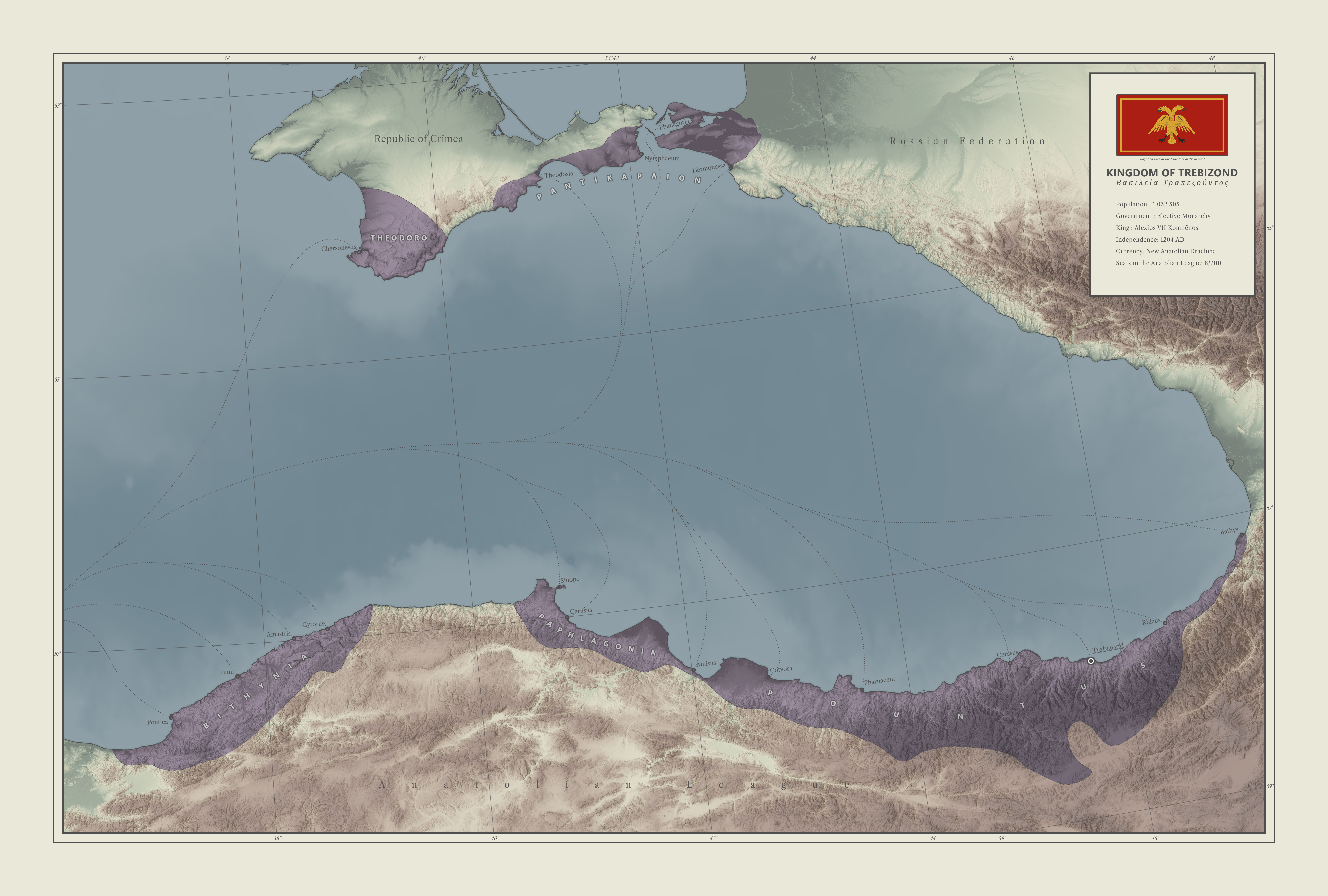
After a much more successful fourth crusade, the Crusaders managed to topple both the Byzantine and Seljuk empires creating a large power vacuum in Asia Minor. Wanting to avoid the inefficiency and failures of the former eastern Christian empire they set up a kind of Anatolian EU almost 800 years before the EU of our era.
The idea was to combat corruption by having several small governments making sure that the bureaucratic distance between the tax collectors and the government was as small as possible, while still allowing for a large central army to be raised in times of need.
The union has survived up until our very own day preserving the Greek Orthodox tradition in Anatolia.
While most nations in the Union have abolished monarchism in favor of republicanism, the small Kingdom of Trebizond still clings on to its monarchist past.
yeah it doesnt deserve to be called great britian after all of the mass genocides and gassingsI feel you should just call it England.
Skallagrim
Banned
This is the first map of a series I plan on doing of the Reach, with all of the place names in native languages. The southern Reach, of which this area is the northern part, speaks an analogue of Dutch; of course, there are regional dialects over such a large area, which I tried to represent on the map (kuip in the north vs kiep in the south for example).
This is very interesting. It really does sound like some uncanny valley version of Dutch.
If you'll allow the criticism, my only "objections" are to Hijgaarden and the use of Kiep/Kuip. Those both stand out because they are obviously incongruent Anglo-influences. Using 'hij' references 'high', but in Dutch, it is 'hoog' (compare German 'hoch'). There's actually a place called Hoegaarden in Belgium (and also a brewery/beer with that name). That or Hoogaarden would be a realistic take on "Highgarden". (In the official Dutch translation, the alternative Hooggaarde is used.)
In Dutch, kiepen is a verb that roughly means "to toss" or "to tip (over)". Meanwhile, kuip means "tub" (as in bathtub). Neither has anything to do with a stronghold. The English verb "to keep" as an alternative to "to hold" isn't used. The Dutch equivalent to English place-names including "keep" is something ending in "burg", "burcht" or "veste". For instance, Brijtwaterveste. (Technically the 'brijt' in that name is obviously from un-Dutch and exclusively English 'bright', so that stands out as well, but it could realistically be a pseudo-Dutch word meaning something else.) If you intend to make dialects different, you can use 'burg'/'burcht' in one region, and 'veste' in another region.
I was thinking more about the ethnic cleansing aspect, though perhaps they would call it Britai, if they go Arthurian and such. It depends on which groups the rulers here deem as foreign. Really, one of the biggest not issues is if they go after those classified as capitalists or intellectuals by Pol Pot standards, which is nearly the entirety of the population. Also a lot more likely the Monarchy would go to the Channel Islands, like they did during the English Civil War.yeah it doesnt deserve to be called great britian after all of the mass genocides and gassings
- Status
- Not open for further replies.
Share: