Deleted member 107125
How is Japan partitioned?Largely the same, with some minor differences (united Korea, partitioned Japan, independent Hyderabad, independent Andaman and Nicobar Islands, China without Xinjiang, Tibet, and Yunnan)
How is Japan partitioned?Largely the same, with some minor differences (united Korea, partitioned Japan, independent Hyderabad, independent Andaman and Nicobar Islands, China without Xinjiang, Tibet, and Yunnan)
How is Japan partitioned?
@Etruscan-enthusiast35 Did you miss this?I would like to request a map of Bulgaria in the same style as the Germany map.
It should consist of the territory of Bulgaria before the end of WW1:
View attachment 478038
Plus the Edirne and Kırklareli Sanjaks of the Edirne Vilayet (ie northern East Thrace), Southern Dobruja, and the Bulgarian majority parts of OTL North Macedonia on this map:
View attachment 478039
Give the Albanian majority portions of Kosovo and North Macedonia to Albania.
Lastly, the southern half of East Thrace + Gallipoli should be part of Greece. Essentially, give the parts of Adrianople Vilayet that weren't given to Bulgaria to Greece. This results in the Greek parts of East Thrace being an exclave, cut off from the rest of Greece by Bulgaria.
@Etruscan-enthusiast35 Can you do this?
I would like to request a map of Bulgaria in the same style as the Germany map.
It should consist of the territory of Bulgaria before the end of WW1:
View attachment 478038
Plus the Edirne and Kırklareli Sanjaks of the Edirne Vilayet (ie northern East Thrace), Southern Dobruja, and the Bulgarian majority parts of OTL North Macedonia on this map:
View attachment 478039
Give the Albanian majority portions of Kosovo and North Macedonia to Albania.
Lastly, the southern half of East Thrace + Gallipoli should be part of Greece. Essentially, give the parts of Adrianople Vilayet that weren't given to Bulgaria to Greece. This results in the Greek parts of East Thrace being an exclave, cut off from the rest of Greece by Bulgaria.
@Etruscan-enthusiast35 Can you do this?
Greece should have Smyrna. Montenegro should have the borders of the Kingdom of Montenegro before WW1. Bosnia, Romania, and Serbia don't need border changes other than giving parts of Serbia to Montenegro, so they can be colored in. Color in Turkey too.View attachment 479336
I left the other nations uncolored due to you not specifying any real changes for them besides territorial losses.
Greece should have Smyrna. Montenegro should have the borders of the Kingdom of Montenegro before WW1. Bosnia, Romania, and Serbia don't need border changes other than giving parts of Serbia to Montenegro, so they can be colored in. Color in Turkey too.
Can you make the Constantinople region an independent city-state in between Greece and Turkey? Use the borders of the Zone of the Straits but without Gallipoli and East Thrace (so only the pink area).
Can you make the Constantinople region an independent city-state in between Greece and Turkey? Use the borders of the Zone of the Straits but without Gallipoli and East Thrace (so only the pink area).
View attachment 479495
You forgot to give the European part of Constantinople to the independent Constantinople. It's the pink part west of the Bosphorus.
You forgot to give the European part of Constantinople to the independent Constantinople. It's the pink part west of the Bosphorus.
Can you give the rest of North Macedonia that's not part of Albania to Bulgaria?
Can you give the rest of North Macedonia that's not part of Albania to Bulgaria?
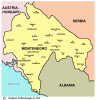
One final thing - give the area surrounding Gusinje (but NOT Plav), plus the area around Ulcinj (but NOT Bar), and the parts of Kosovo IOTL that were Montenegrin on this map (Istok, Pec, Decani, Dakovica, etc) to Albania.
One final thing - give the area surrounding Gusinje (but NOT Plav), plus the area around Ulcinj (but NOT Bar), and the parts of Kosovo IOTL that were Montenegrin on this map (Istok, Pec, Decani, Dakovica, etc) to Albania.
View attachment 479543
so what I was thinking was a French-type tricolour with saffron on the right, a starry green background with a crescent over it, and whiteP
this is the lion and sun from the Persian flag, the Mughal one was a little different, maybe dont use the current Indian flag please coz it’s rather recent
thank you anyways mate
hope i’m not sounding rude
so what I was thinking was a French-type tricolour with saffron on the right, a starry green background with a crescent over it, and white
nice flag