Map Thread XVIII

Status
Not open for further replies.
The most wild maps I saw included Idaho in the Midwest so I figure that's entirely reasonable. Of course, I'm neither Midwestern nor a New Yorker (though I am Pennsylvanian, if only by birth!) so I don't know how inflammatory such a statement might be.

Naw, I think Idaho is wild too, it's Mountain West through and through.

I'd like to ideally slap Upper Michigan, Wisconsin north of the namesake and Fox Rivers, and Minnesota into its own "Northwoods/Upper Midwest" region and slap Iowa, northern Missouri, and the Dakotas in with the Great Plains region, so that the remainder of the Midwest in your map plus my additions can be an overall "Great Lakes/Midwest Proper" region. Minneapolis and Duluth and Marquette different, from Fargo and Des Moines and Bismarck different, from Chicago and Columbus and Pittsburgh, and all that. No worse than the Northeast being safely divided into New England and the Mid-Atlantic.

American regions would be far easier to classify if people could accept different parts of states being parts of different regions.
 

Crazy Boris

Banned
Acadia.png


A little one-off of a hypothetical country made of Canada's Maritime Provinces.

In the leadup to Canada's Confederation in OTL, a faction called the Anti-Confederates, who opposed the whole thing, were fairly strong in Nova Scotia. They even won the province in the first-ever Canadian federal election.

What if the Anti-Confederates got their way, not just in Nova Scotia, but in the whole Maritime region, leaving just Ontario and Quebec to form Canada in TTL.

In this scenario, the three colonies of New Brunswick, Prince Edward Island, and Nova Scotia keep the status quo for another 19 years, until they decide to make their own confederation (with blackjack and lobsters). And so, the Acadian Confederation is born, taking it's name from the French colony that was once there, despite being a British dominion. Even so, the dominion begins to embrace the Acadian past, even adopting the Acadian flag as it's national flag on the 45th anniversary of its founding, probably replacing some red ensign type-deal, and renaming it's currency from Dollar to Franc.

The statistics for area, population, GDP, ethnic groups, and religion are the combined OTL stats for the three provinces. Antoinette Perry is the current Lieutenant Governor of PEI, and Stephen McNiel is the current premier of Nova Scotia.

The parliament diagram is my first time ever making one, and has 68 seats, two for each county of the three provinces. The political parties and makeup aren't really based too much in real life, except for the Liberals and Conservatives being the two major parties.
 
The map/infobox is well-done. But it looks like you added the GDP per capita numbers for the provinces, but GDP per capita is an average. $124k per capita would make this Acadia one of the top 2 or 3 richest countries per capita, while in reality it is likely closer to 40k (with the exact number being found by adding up the population and gdp of all three provinces and dividing gdp by population)
 
Here is some more progress on my French HRE map. Almost finished Western Europe. I tried to keep things fairly detailed but avoid too much clutter. I still need to do Eastern Europe but the basemap I used seems to have sparse information on that.

Big fan of your work! It looks very nice.
 
Acadia.png


A little one-off of a hypothetical country made of Canada's Maritime Provinces.

In the leadup to Canada's Confederation in OTL, a faction called the Anti-Confederates, who opposed the whole thing, were fairly strong in Nova Scotia. They even won the province in the first-ever Canadian federal election.

What if the Anti-Confederates got their way, not just in Nova Scotia, but in the whole Maritime region, leaving just Ontario and Quebec to form Canada in TTL.

In this scenario, the three colonies of New Brunswick, Prince Edward Island, and Nova Scotia keep the status quo for another 19 years, until they decide to make their own confederation (with blackjack and lobsters). And so, the Acadian Confederation is born, taking it's name from the French colony that was once there, despite being a British dominion. Even so, the dominion begins to embrace the Acadian past, even adopting the Acadian flag as it's national flag on the 45th anniversary of its founding, probably replacing some red ensign type-deal, and renaming it's currency from Dollar to Franc.

The statistics for area, population, GDP, ethnic groups, and religion are the combined OTL stats for the three provinces. Antoinette Perry is the current Lieutenant Governor of PEI, and Stephen McNiel is the current premier of Nova Scotia.

The parliament diagram is my first time ever making one, and has 68 seats, two for each county of the three provinces. The political parties and makeup aren't really based too much in real life, except for the Liberals and Conservatives being the two major parties.

Kind of shocked Gaelic isn't a bigger deal in an independent Acadia, given it played a major role in regional identity.
 
Acadia.png


A little one-off of a hypothetical country made of Canada's Maritime Provinces.
I can't help but feel that if they were reaching back to make their own culture and identity they might have started by renamining some counties., given there are three Kings, three Queens, and two Victorias. I also feel that having American, British, Scots-Irish, or Crown Royalist (who knows, people might make it a thing) as ethnicities. I expect a lot of people who went there originally came from the Thirteen Colonies and the United States. Also, African-American probably isn't the best term to use. And there are a lot of people here claiming to be French. Unless they are new arrivals, I would have expected them to claim the Acadian ethnicity. Similar in the United States, where twenty one million people claimed American as their ethnicity in the 2017 census. I also can't see that flag being used. Yes, some people claimed it as their flag, but the other French communities rightfully wanted nothing to do with the Tricolor. And here it is with anglophonics using it.
 
Here's a map of a rather scary scenario: the US expands a lot more, and the balance between free states and slave states consequently remains.

Map of the USA in 1900. Green=free, yellow=slave.

usa6.png
 
Here's a map of a rather scary scenario: the US expands a lot more, and the balance between free states and slave states consequently remains.
Of course. Always need to make sure thigns are gerrymandered so Slavocrats get at least half of the Senate. Seriously, I can't see the North being extremely supportive of this, Mexico had slavery abolished and they would be moving south into heavily populated areas. That, and the North was simply getting the poorer land. No offense, but it seems like a lot of the states were made first, and moved backwards, I just feel the green could and should do with four states less, given how useless or impassible not much of the land was a century back.

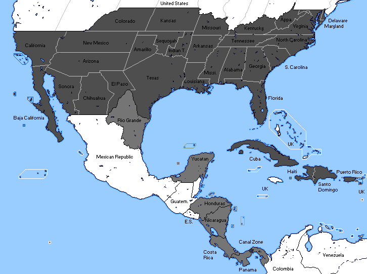
Just another CSA victory (with butterflied slave Kansas and South California) and further expansion map.
dd938zf-417dcf5e-1f4b-4a80-8813-c1afabd3e918.png
What is going on with Sequoyah and the Indian Territory? And I imagine the Planters wouldn't want to be giving so many Senators to Western States. Also the issue about virtually everyone on Hispaniola being either Black or 'High Yellow'. The Dominican Republic kicked out the Spanish a second time around the American Civil War, because they suspected they would try reestablishing slavery. And, as Spanish laws of casta had it that even one drop of 'Negro' blood in you made your spouse unable to get political office at the very least... Yah, they won't be having a good time. I feel the Confederates would just avoid the island entirely.
 
Last edited:
Map 2.png


Map of the Federated States of Dixie

After the French-and-Indian War, Great Britain takes possession of France's territories west of the Mississippi (which are much more populated than in OTL) instead of Spain. GBR then reorganizes the entirety of their North American colonies into North and South with the Ohio River, the Maxon-Dixon, and the Potomac being the main demarcation lines.

The American Revolution happens but is put down eventually as the North and the South are reluctant to join forces. The French Revolution still takes place and Napoleon still comes to power. During the Napoleonic Wars, the stress put on the colonies by the British causes the rebellion to start anew (largely spurned on the the sizable French minorities in both the North and the South), but it is put down in the North. In the South however the rebels have much more success and are eventually able to win their independence under General Andrew Jackson.

Now the South is an independent presidential republic while the North (which includes most of modern day Canada) forms the Commonwealth of America.
 
View attachment 464991

Map of the Federated States of Dixie

After the French-and-Indian War, Great Britain takes possession of France's territories west of the Mississippi (which are much more populated than in OTL) instead of Spain. GBR then reorganizes the entirety of their North American colonies into North and South with the Ohio River, the Maxon-Dixon, and the Potomac being the main demarcation lines.

The American Revolution happens but is put down eventually as the North and the South are reluctant to join forces. The French Revolution still takes place and Napoleon still comes to power. During the Napoleonic Wars, the stress put on the colonies by the British causes the rebellion to start anew (largely spurned on the the sizable French minorities in both the North and the South), but it is put down in the North. In the South however the rebels have much more success and are eventually able to win their independence under General Andrew Jackson.

Now the South is an independent presidential republic while the North (which includes most of modern day Canada) forms the Commonwealth of America.
I feel that East Florida would also be a thing here. And possibly that West Florida goes further north, so it is a viable state. And I imagine there will be legal issues due to the mouth of the Mississippi now being near two states, rather than solely in one.
 
Top
Status
Not open for further replies.
Top