It was not formerly Russian. Hell, Russian Poland was basically what the Austrians and Prussians have them after the Napoleonic Wars. Trans-Carpathian Ruthenia had nothing to do with Russia territorial up until WWII, even if they did call themselves Rusyn and want to join the them,A certain amount of interwar Czechoslovakia was former Russian territory (Carpathia), as well as the issue with its northern border having taken a chunk of Poland in this map.
You are using an out of date browser. It may not display this or other websites correctly.
You should upgrade or use an alternative browser.
You should upgrade or use an alternative browser.
Return of Horrible Educational Maps
- Thread starter Westphalian
- Start date
Well, yes, that too. Mercator projection itself already kinda qualifies as educationally bad, no matter how well all other map aspects might be. Unrelated, according to reddit this was from a video about the Spanish Civil war:
Looks like a giant blue lobster claw is coming out of the Black Sea.
They made North Macedonia look oddly testicular.Is this real, man, what the fuck, how do you even get those borders?
Also popular: Messing up the Eastern Mediterranean
Looks like Europe farted and North America is slowly taking a step back lest he smell the fumes.
The distribution partners of True Scale Miniatures ltd.
Seems they're using the old ROC's claimed borders for China.
On account of submerging, according to reddit this is on a school wall (though they didn't specify which school)
Looks like the "Is Europe a continent?" debate has been settled for good.
Just found this in the portuguese-speaking wikipedia about my home-state of São Paulo:
Well, anthropomorphized Brazil's sure enjoying slurping up them spaghetti noodles.
Last edited:
Judging from how the Arctic Circle line jumps at Iceland and the White Sea (and if you dare to look closer it also has fits in Greenland and Siberia) the segments of this globe were glued together rather sloppily.

Although to be fair a sloppy assembly wasn't what made this globe horribly bad.

Personal "favourite": The French-Austrian border.
Luckily I'm old enough for booze, so I'll now be drinking until I've forgotten that.
Although to be fair a sloppy assembly wasn't what made this globe horribly bad.
Personal "favourite": The French-Austrian border.
Luckily I'm old enough for booze, so I'll now be drinking until I've forgotten that.
AAAAAAAAAAAAAAAAAAAAAAAAAAAAAAAAAAAAAAAAAAAAAAAAAAAAAAAAAAAAAAAAAAAAAAAAAAAAAAAAAAAAAJudging from how the Arctic Circle line jumps at Iceland and the White Sea (and if you dare to look closer it also has fits in Greenland and Siberia) the segments of this globe were glued together rather sloppily.
View attachment 459609
Although to be fair a sloppy assembly wasn't what made this globe horribly bad.
View attachment 459610
Personal "favourite": The French-Austrian border.
Luckily I'm old enough for booze, so I'll now be drinking until I've forgotten that.

After WWII a conference was held in San Francisco that contemplated a Kurdistan from the Mediterranean to the Persian Gulf. The notion was quickly abandoned but not by everyone. Some Kurdish people still envision a huge Greater Kurdistan like the one outlined on the map above.
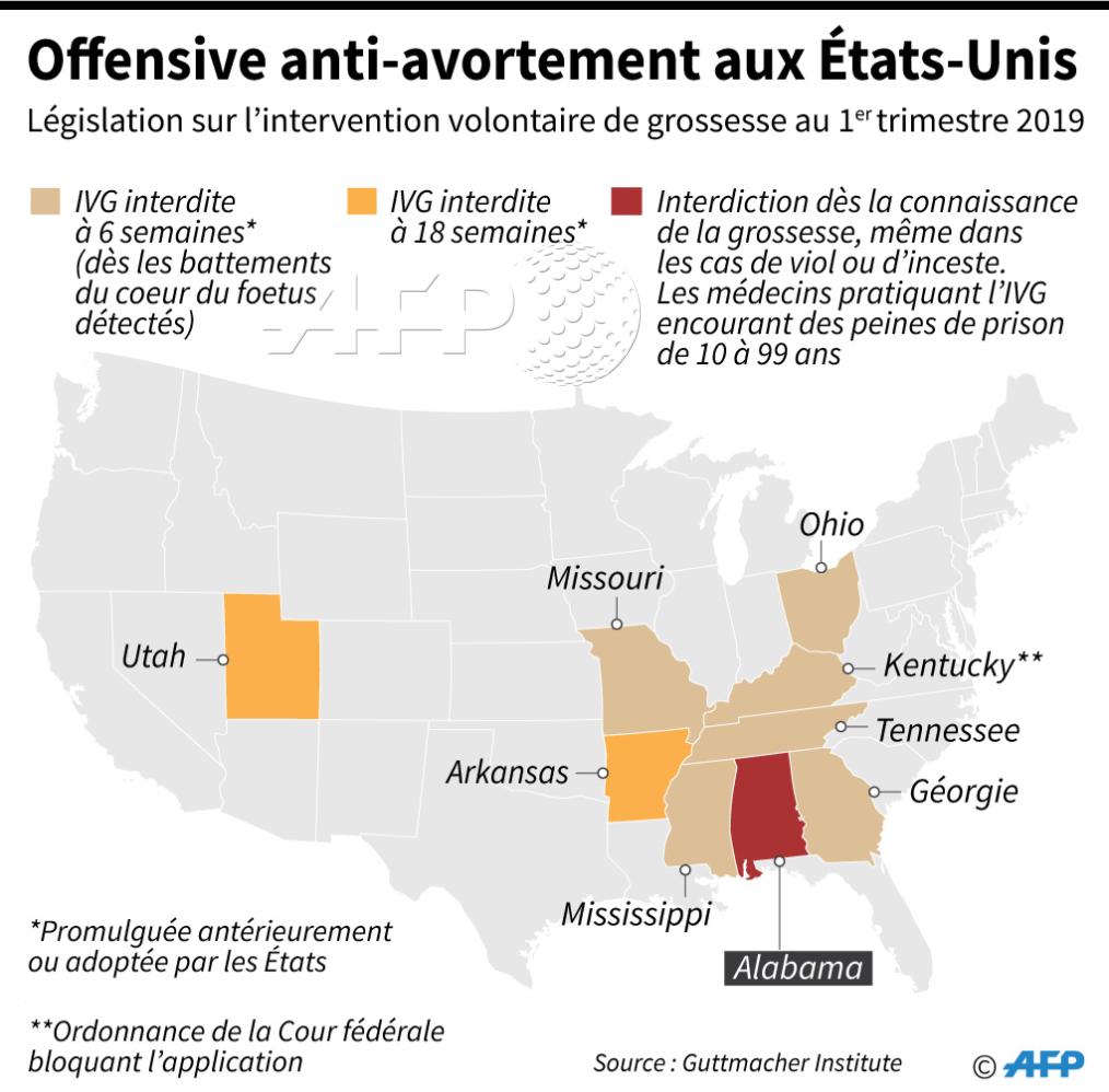
This isn't *that* bad, but this map from AFP about recent abortion laws in the US features some... strange... state shapes
https://twitter.com/afpfr/status/1128948202579718146
https://twitter.com/afpfr/status/1128948202579718146
This isn't *that* bad, but this map from AFP about recent abortion laws in the US features some... strange... state shapes
It looks like the US is made out of jelly.
Crazy Boris
Banned
This isn't *that* bad, but this map from AFP about recent abortion laws in the US features some... strange... state shapes
https://twitter.com/afpfr/status/1128948202579718146
Missouri lookin' thicc af
Apologies if this has been posted before.

Those land bridges might be excusable (they didn't want to attach those islands separately to the wall) but then you notice Alaska and Central America (digging the Panama Canal must have been quite the task there)
Crazy Boris
Banned

I wonder whatever happened to this airline.
Went bankrupt from lawsuits after a plane headed to Guangzhou ended up landing in ISIS-held territory in eastern Syria. Pilots blamed it on some sort of faulty maps hindering navigation or something.
Ahhh, everyone of a certain age remembers the day East Prussia sank into the sea.
Though it didn't make the news in the Netherlands, due to that sinking at the same time... apart from Texel and a couple of bits of Zeeland, apparently.Ahhh, everyone of a certain age remembers the day East Prussia sank into the sea.
Complete with Israel and additionally an Iran on the Tigris (And Finland with post continuation war borders, no Arctic coast)Though it didn't make the news in the Netherlands, due to that sinking at the same time... apart from Texel and a couple of bits of Zeeland, apparently.
Not to mention that the countries are visibly labeled in German (admittedly it claims that it's a German map) but they made quite some errors with that as well.
Not only the the lack of the Umlaute, whoever typed those labels wasn't very accurate when typing the names (Litaueh, Letyland, Griecheniand and Alberien have obviously missed to hit the right key, not sure what is was with Tunio; oh and I just noticed Frannreich)
Not only the the lack of the Umlaute, whoever typed those labels wasn't very accurate when typing the names (Litaueh, Letyland, Griecheniand and Alberien have obviously missed to hit the right key, not sure what is was with Tunio; oh and I just noticed Frannreich)
Considering the titles on the books, the unfashionable typewrighter, and whatever stand the laptop is on, I doubt anything in this room is meant for anything more than a photo shoot or making someplace look fancy and suitable for gentlemen. What do you call people who move into gentrified areas! Anyways, even the plant seems to have wires. Fortunately there is a backup globe here. And you have to admit, they have a good reason for connecting Islands to continents by way of thick landbriges. Otherwise they loose the islands, like they did with Iceland, the Caribbean, and my, they moved Japan to a weird spot. At least We know these weren't made in China, or they would have shown Taiwan connected to the mainland like Hainan is.Apologies if this has been posted before.
Louyan
Banned
But they do show her. Just to the right and a bit up than Hainan.At least We know these weren't made in China, or they would have shown Taiwan connected to the mainland like Hainan is.

Share: