I’ve got a couple of maps for people to do if they could: one of Europe and one of the Middle East. The TL is one where (for a bunch of reasons) Germany and Turkey get partitioned at the end of the Second World War. Some of the changes might be a bit fiddly so just PM me if you’d like more information or explainers. It would be great if the maps could have name labels but that’s not vital.
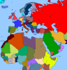
Europe
· All of the borders are the same unless specified below.
· UK and Ireland are united.
· Belgium, Luxembourg and the Netherlands are the ‘Benelux Union’.
· France also includes the OTL Saarland Province.
· OTL Catalonia province is independent.
· Italy doesn’t include OTL South Tyrol and Friuli Venezia Giulia provinces.
· Austria is made up of OTL Austria, Slovenia and the above Italian provinces.
· OTL Saxony is independent, called ‘Saxony’.
· OTL Bavaria is independent, called ‘Bavaria’.
· OTL Baden-Wurttemberg is independent, called ‘Baden-Wurttemberg’.
· OTL Hesse is independent, called ‘Hesse’.
· OTL Rhineland-Palatinate and North Rhine-Westphalia are independent, called the ‘Rhineland’.
· OTL Schleswig-Holstein, Lower Saxony, Bremen and Hamburg are independent, called ‘Hanover’.
· OTL Czech Republic is called ‘Czechia’.
· OTL Mecklenburg-Vorpommen, Berlin, Brandenburg, Saxony-Anhalt and Thuringia are independent, called ‘Brandenburg’.
· OTL Kaliningrad Oblast and Warmian-Masurian Voivodeship are independent, called ‘Prussia’.
· OTL Slovakia and Poland (minus Warmian-Masurian Voivodeship) are independent, called ‘Poland-Slovakia’.
· OTL Serbia, Kosovo, Albania Croatia and Bosnia are independent, called ‘Yugoslavia’.
· OTL Greece, Macedonia, and the Istanbul, West Marmara, Aegean and East Marmara regions of Turkey are independent, called ‘Greece’.
· Soviet borders are as in OTL minus the Kaliningrad Oblast.
Middle East
· As above, borders are the same unless specified below.
· All ‘regions’ are references to the NUTS statistical regions of Turkey, unless otherwise specified.
· TTL’s Greece is as above.
· OTL Iraq, Syria, Lebanon, Israel, Palestine, Saudi Arabia and the Hadhramaut, Al Mahrah, Shabwah Governates of Yemen are independent, called Arabia.
· OTL Mediterranean, Central Anatolia, West Anatolia, West Black Sea Regions are independent, called Turkey.
· OTL Southeast Anatolia Region is independent, called Kurdistan.
· OTL Armenia and Central East Anatolia, Northeast Anatolia, East Black Sea Regions are independent, called Armenia.
· OTL U.A.E., Bahrain, Qatar are united as the ‘U.A.E.’.
· OTL Dhale, Lahij, Abyan, Aden Governates of Yemen are independent, called ‘Aden’.
· OTL Yemen (minus the bits in Arabia and Aden) are independent, called ‘Yemen’.
· If they fit in the map, Sudan and Egypt are one country (called ‘Egypt’) and Ethiopia, Eritrea and Italian Somaliland are one country (called ‘Ethiopia’).
· Soviet borders are as in OTL minus Armenia.
I understand that that’s a lot of work but I’d be really grateful if somebody could see what they can do with that.
Thanks!
")
