Map Thread XVIII

Status
Not open for further replies.
Apex Earth: 2200 - sea level -100m, New Ice Age effects, and the old fashioned Mediterranean remains, with a lot of historical artifacts and sites still intact (starting to get tourists again!) while everywhere else had them inundated for seventy-five years.

N9Obu9m.png


I think I'll add notes to this one for each mega-engineering or geo-engineering project, and the major climate or local conditions that have changed, and then work on political boundaries again later, when I have a better idea of how they mesh with geography.
 
Apex Earth: 2080 - Sea Level +10m and places that remain dry and protected below sea level in grey-pink. So far it's just the Mediterranean that has this.

2Dx9FCD.png


The Mediterranean was dammed to protect these coastlines, with estimates for the costs far lower than protecting each individual city or port. There were many investors, the European Union, the North African States, Israel, Turkey, and Russia.

Next step is showing the 'Dammed Cities', places that were protected in smaller projects (New York, Singapore, London, Paris, Tokyo), the 'Sunken Cities', places that were abandoned (Hamburg, New Orleans, a few more) and figuring out where else we'd actually change the world map in the next sixty years. It looks like something could be done in northeast China, near Shandong, and maybe something to protect the Delaware Bay, Delmarva, area. I was also thinking about a failed project to protect the Baltic Sea coast, not sure how to depict it on the map yet.

In this setting, 2080 is fifteen years after hyperspace technology is discovered, and five years before first contact / alien invasion.

Paris is pretty far inland...
 
Paris is pretty far inland...

I had read somewhere that it would be vulnerable to regular flooding from a +10m rise in sea levels. Internet is telling me Paris itself is 35m above sea level, on average, so maybe.

It's on a river, no? That could lead to flooding.

Weather in the global warming world will suck, so that could be the main factor. How ever often the Seine floods right now, I'd guess it will be ten times that with rising sea levels.
 
Apex Earth: 2200 - The difference in coastlines and ice-caps from 2080 to 2200. Greenish areas were inundated and later revealed. Light blue is ice shelf or ice cap. Darker blue are places that were only flooded after the ice age.


HTkw8sn.png


Last one for today, just a simple overlay that turned out to be quite informative.
 
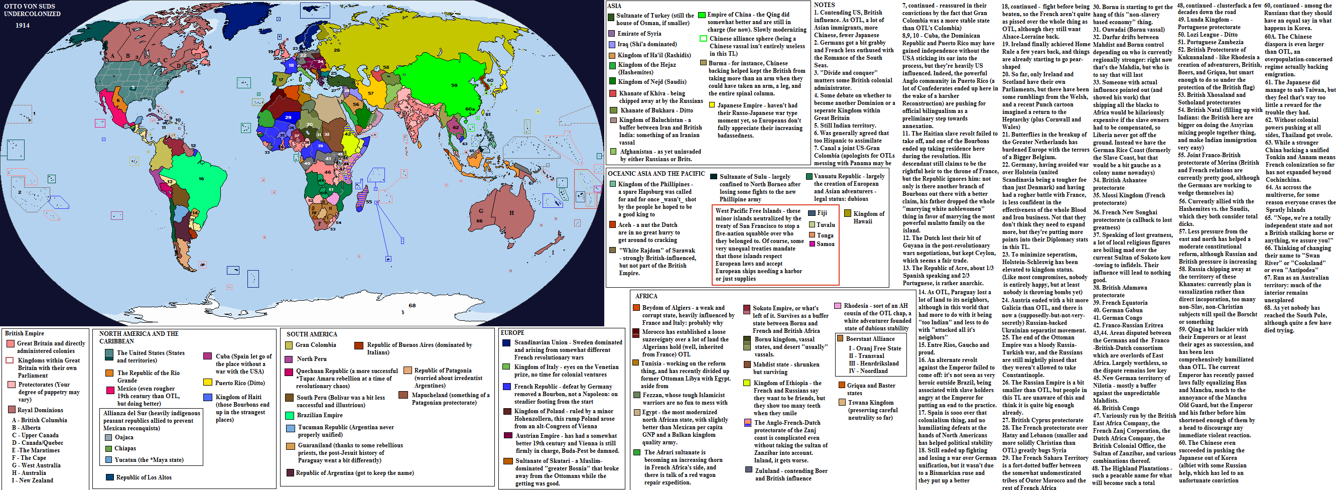
A (relatively) easy map, mainly so I can put off doing work on commissions I need to finish. :coldsweat: Based on Travel Guide #9 by OttoVonSuds. Some extra changes, because I'm cuckoo for cocoa puffs butterflies. Ideas for Africa taken from the excellent Male Rising timeline by Jonathan Edelstein.

If I have (almost inevitably) made some errors, let me know.

dd2559x-999f17e6-a445-4a86-a868-87455987e292.png


Oh, a few extra details - won't put them on the map since I've already edited and reposted this here and on Deviantart three times. :confounded:

That big "Kashmir" is the Sikh Empire. Put up a hard enough fight that it ended up a British vassal rather than being broken up as OTL, and it's a useful buffer: takes care of the occasional Afghan invasion rather than the British having to dirty their hands themselves.

The wee state above it is Balti.

Egypt managed to secure Palestine in the general collapse of the ottoman Empire and makes beaucoup bucks (or piastres) off the Pilgrim trade. It has also held onto an equal number of shares in the Sinai canal to the French.

Haiti (responding to a comment from @Historyman 14 ) has been slavery-free for a while, but it is still dominated economically and politically by an elite of whites and light-skinned, French-speaking blacks. (There is also a sizable Asian immigrant population: there are more Indians, etc. in the British Caribbean, and more Chinese everywhere)
 
Last edited:
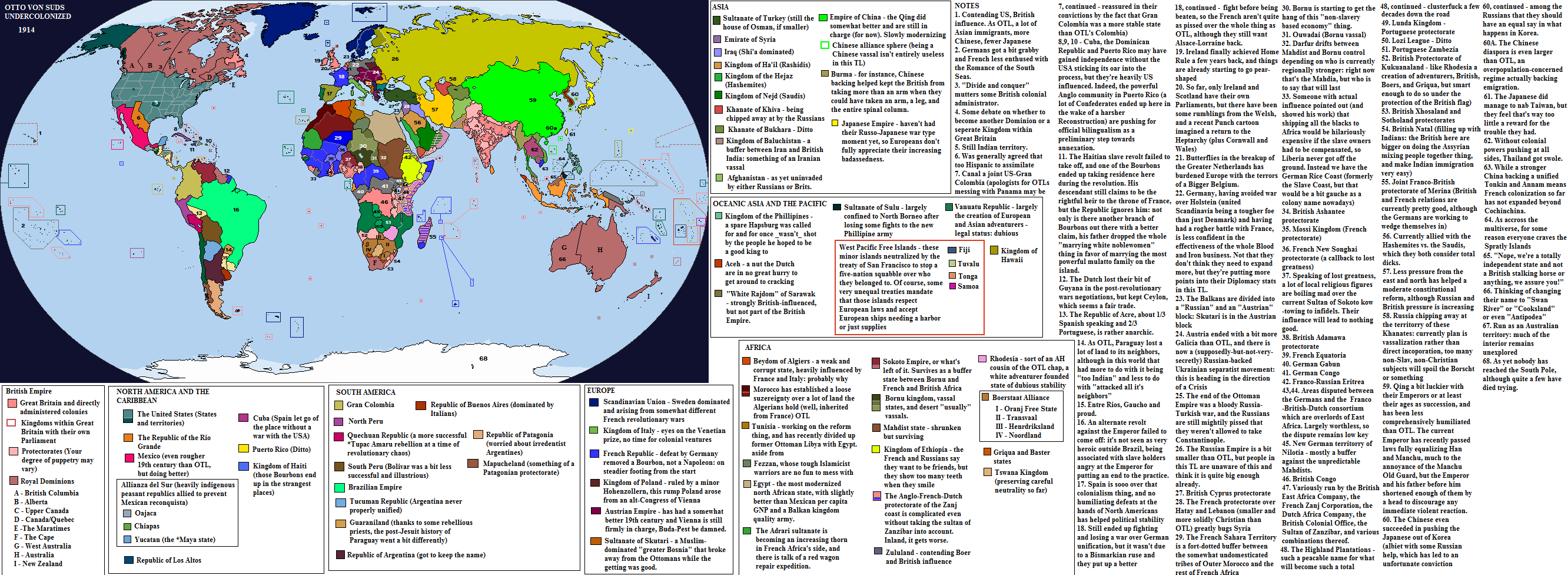
A (relatively) easy map, mainly so I can put off doing work on commissions I need to finish. :coldsweat: Based on Travel Guide #9 by OttoVonSuds. Some extra changes, because I'm cuckoo for cocoa puffs butterflies. Ideas for Africa taken from the excellent Male Rising timeline by Jonathan Edelstein.

If I have (almost inevitably) made some errors, let me know.

You have two 33s. Nice scenario though!
 
A (relatively) easy map, mainly so I can put off doing work on commissions I need to finish. :coldsweat: Based on Travel Guide #9 by OttoVonSuds. Some extra changes, because I'm cuckoo for cocoa puffs butterflies. Ideas for Africa taken from the excellent Male Rising timeline by Jonathan Edelstein.

If I have (almost inevitably) made some errors, let me know.
The Southern Cone also taken from Male Rising?
 
A (relatively) easy map, mainly so I can put off doing work on commissions I need to finish. :coldsweat: Based on Travel Guide #9 by OttoVonSuds. Some extra changes, because I'm cuckoo for cocoa puffs butterflies. Ideas for Africa taken from the excellent Male Rising timeline by Jonathan Edelstein.

If I have (almost inevitably) made some errors, let me know.

dd2559x-9c9a91db-4762-47dd-8d0b-43f5a4aa9aa8.png
There seem to be two #33's
 
Influenced by, especially in the borders of the Mapuche state, although all the states are mentioned in Otto's scenario.
Ahh yes, just realized their aren't independent states in southern Brazil here. A shame, as it would have meant even more places with loads of Italians. Did he specify a Gran Colombia? I feel that as they still have Ecuador they would just be considered Colombia.
 
Ahh yes, just realized their aren't independent states in southern Brazil here. A shame, as it would have meant even more places with loads of Italians. Did he specify a Gran Colombia? I feel that as they still have Ecuador they would just be considered Colombia.

No he didn't: I just wanted to mix it up by making one of the Latin American nations bigger than OTL. And you're right, Gran Colombia is a retrospective name, not what they called themselves at the time. Perhaps they lost and later regained Ecuador?
 
A (relatively) easy map, mainly so I can put off doing work on commissions I need to finish. :coldsweat: Based on Travel Guide #9 by OttoVonSuds. Some extra changes, because I'm cuckoo for cocoa puffs butterflies. Ideas for Africa taken from the excellent Male Rising timeline by Jonathan Edelstein.

Hard to get alternate U.S. state borders look so nice while also avoiding cliches- good work there!
 
A (relatively) easy map, mainly so I can put off doing work on commissions I need to finish. :coldsweat: Based on Travel Guide #9 by OttoVonSuds. Some extra changes, because I'm cuckoo for cocoa puffs butterflies. Ideas for Africa taken from the excellent Male Rising timeline by Jonathan Edelstein.

If I have (almost inevitably) made some errors, let me know.

dd2559x-999f17e6-a445-4a86-a868-87455987e292.png

Tell us more about Haiti. If the slave rebellion failed to take off, and the Bourbon rule it, how does it look like? I mean, when did slavery end and the white/black population?

Next World War?

What would happen to Qing if the Qing screws everything up still and is booted out of power. (Republican!China is an must.)
 
Top
Status
Not open for further replies.
Top