Crazy Boris
Banned
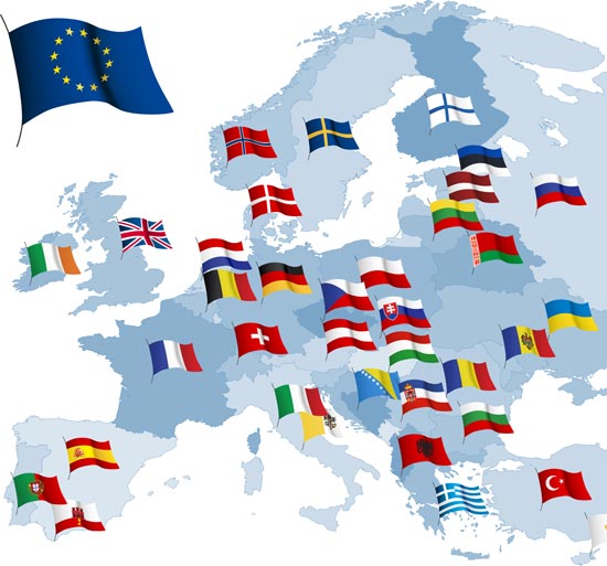
Spot the mistakes.
Montenegro, Slovenia, San Marino, Luxembourg, Kosovo, Andorra, Monaco, Malta, and Liectenstein aren’t important enough to get their own flags but Gibraltar is?
Spot the mistakes.
Better yet is snagging the design from the Union Jack.You're not a real Celtic nationalist until you demand everything from Gaul to Anatolia!
I'm guessing the issue may be how Turkey, Bosnia-Herzegovine, Switzerland, Norway, Russia, and others are not in the EU. Also, the Greeks were such poor sports that they bribes someone to have the Albania flag blot out Macedonia.Montenegro, Slovenia, San Marino, Luxembourg, Kosovo, Andorra, Monaco, Malta, and Liectenstein aren’t important enough to get their own flags but Gibraltar is?
Well, it could be the European Council, who invented the flag, but than Belarus, Gibraltar and the Vatican (and the missing ones) are wrong.I'm guessing the issue may be how Turkey, Bosnia-Herzegovine, Switzerland, Norway, Russia, and others are not in the EU.
but of course! we had to get them back for sinking Tasmania!We have always been at war with...um, greater Malaysia, Hong Kongese Hainan, Lesser Indonesia, China-Korea, Taiwan and Japan-Sakhalin?
but of course! we had to get them back for sinking Tasmania!
Asians bought it up. Apparently to fill in Tokyo Bay and a far bit of the Japanese coast. I am unsure if Hong Kong got what remained of Tasmania to expand themselves to Hainan levels, or if it instead went to help make the Thai Canal now impossible beyond any doubts.r/mapswithoutTasmania
We have always been at war with...um, greater Malaysia, Hong Kongese Hainan, Lesser Indonesia, China-Korea, Taiwan and Japan-Sakhalin?
For WW2, they had an animation about Nazi German conquest. They used the post-1946 borders to represent Germany in 1939. Boy are they lazy with making some maps.Maybe it was more important to them where Hitler was born and decided to act accordingly, who knows...
But speaking of World Wars, one of the PragerU (not sure about the name but meh) videos seems to have tackled WWI...
View attachment 441511
They can't go into the fullest of detail or it will look weird, and if they go halfway we would still find something to pick out.
Hey, notice something wrong?
View attachment 442492
This is actually the main image at the Wikipedia page on the Caribbean plate, the North Americans plate image also contains the split. Unfortunately, the uploader hasn't been active since 2015. I'm still trying to get help on it.That was some earthquake that hit Hispaniola...
Of course its wrong! This is the correct map!Hey, notice something wrong?
View attachment 442492
Speaking of corporate maps have here the next one (though I dunno from which company that one is)
View attachment 442447

Just stumbled over this at reddit. According to them it was from a school library textbook, so it was really meant to be educational.
This time I'll only put the thumbnail here, enlarge it at your own risk. In the meantime I'll go and prepare forks and disinfectant, in case any eye-gouging might be needed...
View attachment 443570
Saxoczechoslovakia? German Courland? Soviet East Finnmark? Romania-Hungary? Enlarged Ulster? Sounds like a new member's timeline to me!Just stumbled over this at reddit. According to them it was from a school library textbook, so it was really meant to be educational.
This time I'll only put the thumbnail here, enlarge it at your own risk. In the meantime I'll go and prepare forks and disinfectant, in case any eye-gouging might be needed...
View attachment 443570