You're not a real Celtic nationalist until you demand everything from Gaul to Anatolia!Please enjoy this dreadful Celtic ultranationalist map (with absolutely horrible flag included at no extra charge). New and magically Celtic 9-county Ulster (which even the DUP have given up as a pipe dream), another massive Cornwall with some of Gloucestershire attached, Celtic Lancashire and Cumbria, Brittany (which is, funnily enough, the only constituent country not massively wanked) and all sorts of other Anglophobic fun.
You are using an out of date browser. It may not display this or other websites correctly.
You should upgrade or use an alternative browser.
You should upgrade or use an alternative browser.
Return of Horrible Educational Maps
- Thread starter Westphalian
- Start date
You're not a real Celtic nationalist until you demand everything from Gaul to Anatolia!
From Iberia to Anatolia...And the entire United States and Canada and Australia and...
I tracked down the source of the "alternate" Europe map:
It was found in a batch of "pictures for Simple German" by the "Office for Simple German" of the Lebenshilfe Bremen (an organisation for the mentally challenged and handicapped based in Bremen):

It was found in a batch of "pictures for Simple German" by the "Office for Simple German" of the Lebenshilfe Bremen (an organisation for the mentally challenged and handicapped based in Bremen):
Because in a perfect world, there would not be a singular monarch with their head attached to their neck /sWhy must it be a vile, heretical republic?
Middlesex_Toffeeman
Banned
I just noticed this; independent Kaliningrad.I tracked down the source of the "alternate" Europe map:
It was found in a batch of "pictures for Simple German" by the "Office for Simple German" of the Lebenshilfe Bremen (an organisation for the mentally challenged and handicapped based in Bremen):
View attachment 441204
Middlesex_Toffeeman
Banned
I agree! Long live Bonnie Prince Charlie!Why must it be a vile, heretical republic?
On another note, why are we not talking about that flag? It looks like a Tesco Value Union Jack with a triskelion thrown in for good measure.
At least they managed to connect their lands.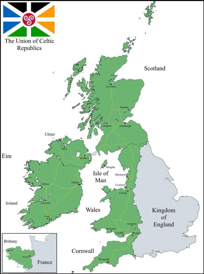
Please enjoy this dreadful Celtic ultranationalist map (with absolutely horrible flag included at no extra charge). New and magically Celtic 9-county Ulster (which even the DUP have given up as a pipe dream), another massive Cornwall with some of Gloucestershire attached, Celtic Lancashire and Cumbria, Brittany (which is, funnily enough, the only constituent country not massively wanked) and all sorts of other Anglophobic fun.
Middlesex_Toffeeman
Banned
Which is probably the reason for Gloucestershire and Lancashire being Celtic.At least they managed to connect their lands.
Yeah, getting those to leave would be hard.Which is probably the reason for Gloucestershire and Lancashire being Celtic.
Those cyka in Bremen are Russophobes for not including Russia in Europe!I tracked down the source of the "alternate" Europe map:
It was found in a batch of "pictures for Simple German" by the "Office for Simple German" of the Lebenshilfe Bremen (an organisation for the mentally challenged and handicapped based in Bremen):
View attachment 441204
Mainly because it's not that bad. Sure it has yellow next to white but if that fades it just gives an appearance of tail.I agree! Long live Bonnie Prince Charlie!
On another note, why are we not talking about that flag? It looks like a Tesco Value Union Jack with a triskelion thrown in for good measure.
It lacks the spanish Galicia to be completely celtic
Please enjoy this dreadful Celtic ultranationalist map (with absolutely horrible flag included at no extra charge). New and magically Celtic 9-county Ulster (which even the DUP have given up as a pipe dream), another massive Cornwall with some of Gloucestershire attached, Celtic Lancashire and Cumbria, Brittany (which is, funnily enough, the only constituent country not massively wanked) and all sorts of other Anglophobic fun.
Middlesex_Toffeeman
Banned
What about the Basques?It lacks the spanish Galicia to be completely celtic
The basques arent even Indoeuropean.What about the Basques?
I just noticed this; independent Kaliningrad.
At least they didn't change it into the Kaliningrad Bay like so many other maps have done. And for losing Kaliningrad Russia did get Belorussia AND Ukraine.
Also: unified Ireland, independent Scotland, Sicily and Sardinia both independent as well, European Turkey also separate (though that might be due to the map being about Europe), but foremost:
West Austria and East Austria.
.
I'm guessing in this timeline Austria started WW2 and the Allies divided Austria into West Austria and East Austria, similarly to Germany IOTLAt least they didn't change it into the Kaliningrad Bay like so many other maps have done. And for losing Kaliningrad Russia did get Belorussia AND Ukraine.
Also: unified Ireland, independent Scotland, Sicily and Sardinia both independent as well, European Turkey also separate (though that might be due to the map being about Europe), but foremost:
West Austria and East Austria.
I'm guessing in this timeline Austria started WW2 and the Allies divided Austria into West Austria and East Austria, similarly to Germany IOTL
Maybe it was more important to them where Hitler was born and decided to act accordingly, who knows...
But speaking of World Wars, one of the PragerU (not sure about the name but meh) videos seems to have tackled WWI...
Don Quijote
Banned
Ulster does have nine counties. My objection is that the border on that map gives it something more like seven and a half.
Please enjoy this dreadful Celtic ultranationalist map (with absolutely horrible flag included at no extra charge). New and magically Celtic 9-county Ulster (which even the DUP have given up as a pipe dream), another massive Cornwall with some of Gloucestershire attached, Celtic Lancashire and Cumbria, Brittany (which is, funnily enough, the only constituent country not massively wanked) and all sorts of other Anglophobic fun.
ST15RM
Banned
Maybe it was more important to them where Hitler was born and decided to act accordingly, who knows...
But speaking of World Wars, one of the PragerU (not sure about the name but meh) videos seems to have tackled WWI...
View attachment 441511

Share: