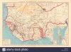
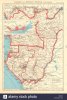
I know it's not what we are accustomed to see but since they are from the official french colonial atlas, i think french should know the best about their territories, but im not sure how long that arrangement lasted.
Our sources are almost always anglocentric so there can be mistakes, like the famous empty blop in eastern libya that in almost every pre-world war I map of colonial Africa has. It was never empty, it was controlled by the senussi emirate, under ottoman protection and ottomans had military outposts in northern chad until their war with italy over libya in 1912, but since french and britain didn't want to acknowledge ottoman claims there they just ignored it, and everbody else just copied those maps.
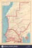
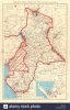
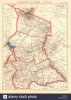
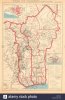
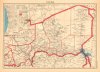
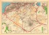
Edit: I did some quick research, French wikipedia page of Territoire d'Aïn-Sefra of western Algeria mentions its borders changed in 1920, 1938 and 1947 and gives links to offical french goverment decrees about them in French Gallica, as far as i can understand with my non existent french, 1938 decree mentions pacifying southern morrocco and establishing a new military territory for that purpose, so we can assume those borders were legit between 1938-1947.I will do some more research later too but we need a french speaker i think
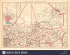
") https://gallica.bnf.fr/ark:/12148/bpt6k65510144/f16.item.zoom
https://gallica.bnf.fr/ark:/12148/bpt6k65510144/f16.item.zoom