You are using an out of date browser. It may not display this or other websites correctly.
You should upgrade or use an alternative browser.
You should upgrade or use an alternative browser.
Q-Bam Historical Map Thread
- Thread starter The Alternative
- Start date
-
- Tags
- historical maps q-bam
I'm almost done with the Americas and Africa.
Anyone got a (clear) map of the divisions of Iran, Southern Rhod., Chile, Nicaragua, Turkey, UK, or the Soviet Union around 1942?
This article on Wikipedia includes a list of former provinces of Iran, though no maps.Anyone got a (clear) map of the divisions of Iran, Southern Rhod., Chile, Nicaragua, Turkey, UK, or the Soviet Union around 1942?
Map of Turkey in 1927:

And, as for Nicaragua, the Spanish article for her departments lists out the history.
Here is a map of the provinces of Turkey in 1942.
https://exhibits.stanford.edu/oss-maps/catalog/nv744yq8514
Counties of England 1890-1965
https://upload.wikimedia.org/wikipe...ng/800px-England_Admin_Counties_1890-1965.png
I have some maps of the USSR's administrative divisions. I'll try to find those when I am home later.
https://exhibits.stanford.edu/oss-maps/catalog/nv744yq8514
Counties of England 1890-1965
https://upload.wikimedia.org/wikipe...ng/800px-England_Admin_Counties_1890-1965.png
I have some maps of the USSR's administrative divisions. I'll try to find those when I am home later.
Last edited:
Here is a map of the administrative divisions of Mongolia and Tuva
https://exhibits.stanford.edu/oss-maps/catalog/dq375fg7674
Here are maps from 1944. There were quite few changes between 1942 and 1944, especially in western Russia and the Caucasus,which I will try to track down.


https://exhibits.stanford.edu/oss-maps/catalog/dq375fg7674
Here are maps from 1944. There were quite few changes between 1942 and 1944, especially in western Russia and the Caucasus,which I will try to track down.
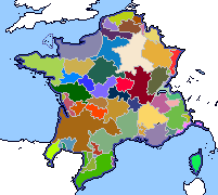
Does anybody have a map of Lotharingia / Francia post the treaty of Verdun?
I'm almost done with the Americas and Africa.
Anyone got a (clear) map of the divisions of Iran, Southern Rhod., Chile, Nicaragua, Turkey, UK, or the Soviet Union around 1942?
If you still need maps of the USSR, I've found an atlas from 1941 which might be useful.
http://istmat.info/node/44869
I think the only major change between 1941 and 1942 would have been the abolishment of the Volga German ASSR.
Last edited:
We all wish there was.Does anyone happen to have a biome map for Q-bam?
Updated the historical changelog with the recent coastal, lake, and dry lake patches
Last edited:
1942 Progress
For whatever reason the file size for this is too large (I don't know why), so I used imgur.
I really need to work on the rest of Indonesia and Mongolia patches for the main qbam thread, so if I could get some of y'all to patch China's provinces (Manchuria included), Finland's provinces, Romania's provinces, the rest of the borders for Nazi Germany, and maybe a coastline or two that's missing, that'd be swell
No love for Lake Cahuilla?View attachment 433612
Updated the historical changelog with the recent coastal, lake, and dry lake patches
If you mean the Salton sea, the lake is only 110 years oldNo love for Lake Cahuilla?
Ah but it's theorized that it was a larger(around 2x), naturally occurring lake up until the 13th or 14th century, presumably when the Colorado River changed paths and stopped feeding into it. That is to my knowledge anyway, unfortunately it's not a very thoroughly researched topic.If you mean the Salton sea, the lake is only 110 years old
yeah but it dried out in and out of time until its disappearance before the Spanish arrival in the region, so its geographical borders will have to change numerous timesAh but it's theorized that it was a larger(around 2x), naturally occurring lake up until the 13th or 14th century, presumably when the Colorado River changed paths and stopped feeding into it. That is to my knowledge anyway, unfortunately it's not a very thoroughly researched topic.
Share: